
Poimen
-
Posts
2,148 -
Joined
-
Last visited
Content Type
Profiles
Blogs
Forums
American Weather
Media Demo
Store
Gallery
Everything posted by Poimen
-
ICON finally brings down some snow over the Piedmont Sunday morning. It also never really gets the precip into VA (Through the daylight hours Sunday).
-
The ICON is coming in really mild for Saturday...no snow to speak of. This with a southerly track, mind you. I'd like to see this model jump on board.
-
I'd include the NW/N Piedmont, too.
-
At this point, I feel fairly confident in a front-end snow for the favored climo areas of NC Saturday afternoon/night, yielding at least a few inches...beyond that confidence is low.
-
Bear in mind that in years past, a reduction of at least 50 percent in the clown maps ends up closer to reality around here. But even with that, there is still a reasonable shot of a widespread 6-12" storm for some on this board (if things remain as they are). Those numbers also seem much more realistic and in line with past events.
-
Still a good thump for many here, per the FV 3. However, those amounts SE of the I 85 corridor are suspect.
-
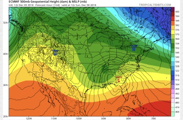
FV3 ends up climbing the coast and smacking the MA. It looks like a front-end snow for the CAD/favored climo areas of NC, transitioning to freezing rain/sleet, then perhaps rain.
-
Perhaps both, but in general I think they're picking up on colder surface temps. The GFS soundings for our area looked considerably colder this run than previous runs through the entire column.
-
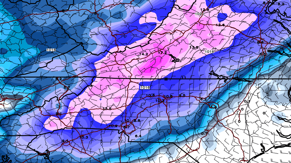
Here's the Kuchera map for the 6Z GFS. Again, widespread 16"-20"+ amounts.
-
I think the models are beginning to sniff the colder CAD air mass. Within the last two model cycles (0Z AND 6z), the EC, GFS, and ICON have all turned colder compared to previous runs. So far, the FV 3 has been leading the way. With that said, don't be surprised if the snow ends up being largely confined to the northern Piedmont/Foothills/Mountains.
-
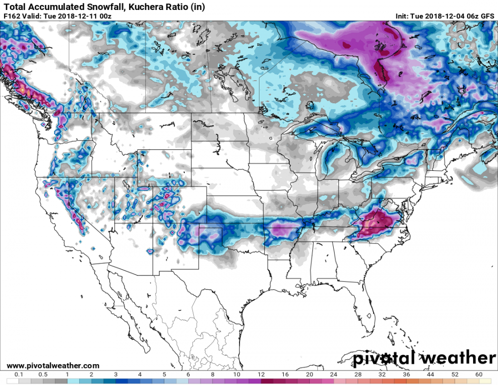
See if this link will work for you: http://www.pivotalweather.com/model.php?m=gfs&p=snku_acc&rh=2018120400&fh=168&r=conus&dpdt=
-
Kuchera map for GFS is widespread 16-22" for much of the NC Piedmont.
-
Not sure how that map is generated, but there really shouldn't be much if any snow outside of the western/northern piedmont (aside from some at the beginning), based off a quick glance of the modeled 850 temps.
-
Looks like a lot of sleet in the Triad Saturday night, per this run.
-
Yeah...1039 high is a bit stronger than previous runs. Let's see where she goes from here.
-
I’m always leary of questioning Dr. No, but is this a classic case of the model underestimating the depth of cold/CAD airmass at this range, or is that just my inner weenie talking?
-
If I had to guess, I’d say this setup produces significant snow for large portions of NC 9 times out of 10.
-
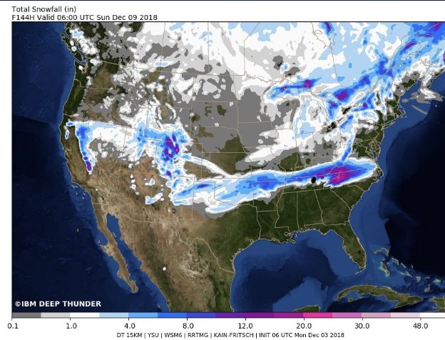
Deep Thunder is on board:
-
Just to clarify: we are now about 120 hours from the front end of the storm...so we are getting pretty close to having a good handle on that part of the storm at least.
-
Yeah...me thinks the old GFS is just playing to its old bias of being too suppressed at this range. The FV3 is a beaut, Clark, with snow arriving in WRN NC mid-day Saturday.
-
Looks like the 6Z FV3 is going to be another winner for many of us. Edit: it snows on the FV3 across much of the upstate and a good deal of NC from mid-day Saturday through late Sunday night. The clown map should be fun.
-
Man...I don't recall ever reading such LR confidence in a RAH discussion as I just read (in regards to a potential winter storm). Reading between the lines, the forecaster seemed bullish. On to the 12Z suite. In-short: A winter storm is expected to impact portions of central NC next weekend. While uncertainty on specific local impacts remains highly dependent on overall track, strength, and arrival time of said system, confidence continues to grow that some sort of wintry mix will occur across the northwestern piedmont of NC. Now is the time to triple check your winter weather supplies and emergency kits, and continue to check back in on the forecast for further updates.
-
y'all have fun staying up for the EURO. I'll catch the update in the a.m. Good luck and good night!
-
Raging rain storm on the GFS for pretty much all of NC. ICON/GGEM similar as well.
-
0Z ICON looked similar, FWIW.


