Poimen
-
Posts
2,148 -
Joined
-
Last visited
Content Type
Profiles
Blogs
Forums
American Weather
Media Demo
Store
Gallery
Everything posted by Poimen
-
who would have ever thought that people in this sub forum would be flipping out for having their 24" clown maps downsized to 15"???
-

-
Based on the crude black and white maps, it looks like the Canadian is finally joining the party, too.
-
The 850s cool as the precip/lift moves in from the SW. All the models have been showing this. The atmosphere is literally cooling from the top down. Its impressive. I don't know that I've ever seen this modeled before.
-
NAM is now running on TT...BTW.
-
(5 Dec 2018): Due to dataflow issues from NCEP, data may be delayed for some American models (NAM, GFS, etc.) this evenin
-
I took a quick glance at the FV 3 on the NCEP site and it looked cold for the NC Piedmont for the duration of the storm, plus it looked like it had the back side deform band on Monday too.
-
RAH shut it down after it dropped more than 1-2" in the Triad.
-
GGEM is kinda on its own. The ICON has a similar look to the others, just too warm.
-
Reeling in these storms in the south is never an easy deal. We just need to be patient, and refuse to freak out over every small model oscillation. Keep in mind that the overall big-picture has remained remarkably steady on the models for several days. Hopefully we'll be preparing for glory come this time Friday.
-
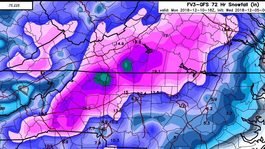
FV 3 Kuchera...not as robust as the GFS but still a good storm (thank you, captain obvious!)
-
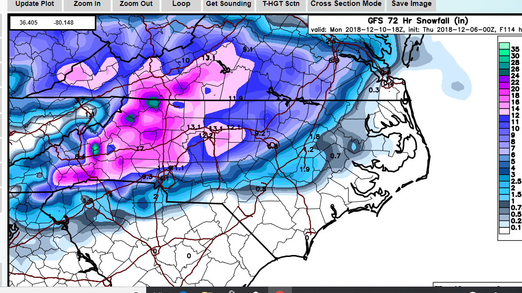
The 12Z GEFS snow mean looks virtually identical to previous runs to me. 10-15" on the means from I 85 west in NC.
-
The UKMET tracks low south along the Gulf coast and then fairly far offshore the SE coast thereafter.
-
The FV 3 is handing off to the coastal low at hour 96. It's a hybrid Miller A/B. I bet you there's a low off the SC coast on the next frame.
-
The Canadian is phasing the northern stream wave into the southern stream wave early--causing a more northward motion of the surface low and warm air overwhelming the CAD. The GFS has no such phasing so early.
-
A close up view of the GFS with Kuchera method:
-
The soundings in the Triad from the GFS are pure snow until 0Z Mon. That's a good 12-16 hours of snow if true.
-
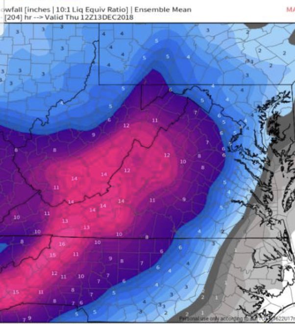
Yeah, the GEFS mean snowfall still focuses the highest totals over WRN NC/SW VA. Widespread 10-15" amounts from I-85 west.
-
I'm hearing a lot of talk about the EURO moving "north" overnight. From what I can tell, it takes the same basic southerly track along the Gulf Coast to off the SE coast as before. Any northward adjustment seems to be in relation to how far north it climbs the coast before exiting out to sea, which should have little bearing on the Saturday night/Sunday portion of the storm. So long as the track remains off the SE coast to Hatteras, I don't really care what it does thereafter. Just my 2 cent.
-
Stole this EPS map from the MA forum.
-
Neither model is as cold as the NAM at the outset, but they're cold enough to get the job done. We're still going to need to wait a few cycles before we can confirm if the NAM's thermal profile is closer to reality.
-
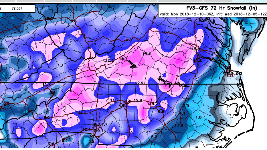
6Z FV 3 does it again. Just like the GFS, it's a classic Miller A. Should be big totals on those clown maps.
-
Waiting on the FV 3 to load is like waiting for my wife at the mall...lol. This thing is slower than molasses going uphill in the middle of January.
-
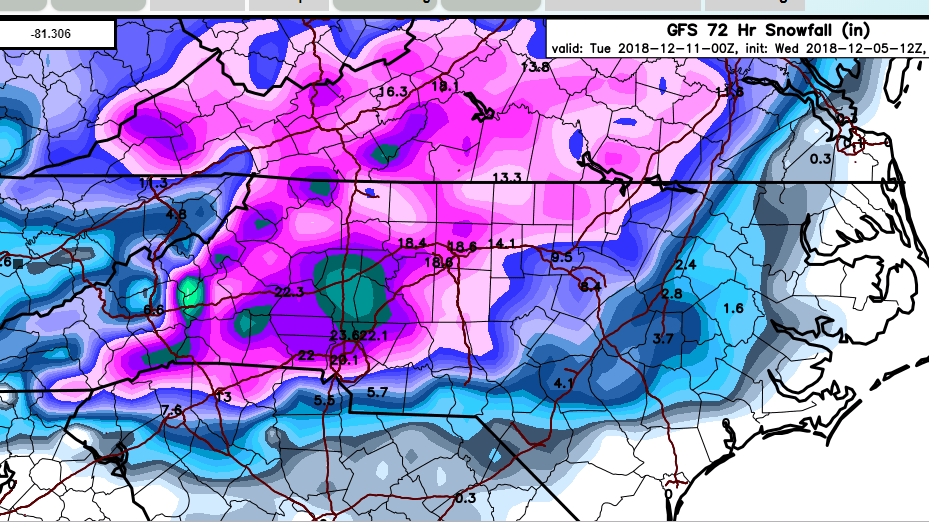
Keep in mind, the GFS is considerably warmer compared to the NAM at the outset and yet it still produces a great storm.