Poimen
-
Posts
2,148 -
Joined
-
Last visited
Content Type
Profiles
Blogs
Forums
American Weather
Media Demo
Store
Gallery
Everything posted by Poimen
-
@lilj4425
-
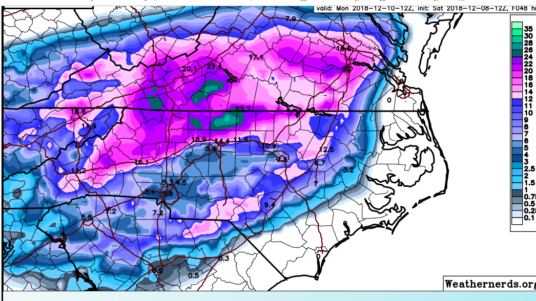
Another 2" qpf run for the RAP with 18" snow totals in the Triad. HRRR isn't far behind.
-
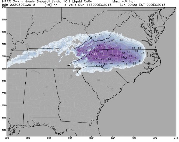
2” per hour rates in the Triad at 9am per the HRRR
-
The 22Z RAP has 2" qpf amounts just south of the Triad and 17" snow totals in the Triad.
-
RAH doubling down in the Triad
-
Holy crap GFS. 1.8" QPF here by tomorrow afternoon.
-
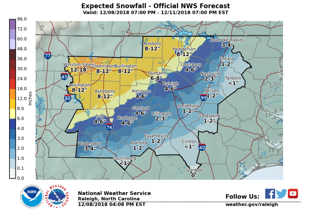
For the Triad, there is more or less a consensus for snow beginning around 1 am and continuing as all snow through 11am-noon, before mixing with and changing to sleet. We'd have to pull 1" per hour rates just to get 10-11". Experience says that is unlikely. So we're probably looking more like 7-9" on the high end, with some sleet on top. That's my call, but I'm of course hoping for more.
-
Got an mPing of snow in Clemmons (near Winston). I'm not expecting it, but it would be nice if we could get things started earlier than ~1am here.
-
SREF snow mean for GSO is just under 10".
-
Here's the HRRR through 18z:
-
Literally, the 18Z HRRR is snow from the Triad to RDU from roughly 1am to 10am. After 10, it transitions to sleet at RDU before rain around noon. It does bring sleet into the Triad by 11-noon,but by then 12 or more inches of snow has fallen.
-
The RAP...FWIW...through 15Z tomorrow has nearly 1" qpf in the Triad, all of which should be snow per model soundings. It does have the 700 and 850 mb warm nose, but it keeps it confined to the SW Mountains, over to Charlotte, and then NE toward the Triangle.
-
Same as above, this time at 850mb:
-
Top image is the last frame from the most recent HRRR at 700mb. You can see the warm nose very clearly. Bottom image is from the 12Z NAM at the same time. Both models have it, but the NAM is more pronounced.
-
Bet it was the 700mb temps on the EURO.
-
A question: I'm wondering if the last few cases of warm noses winning out occurred in conjunction with a similar well-placed CAD?
-
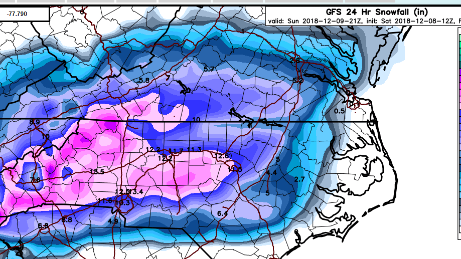
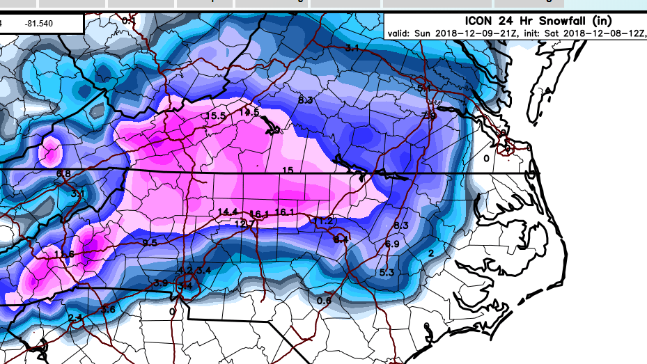
GFS and ICON clowns:
-
Actually...looking at the RGEM charts, it is blow torching at 850 by 12Z tomorrow. This is way warmer at this level than any other guidance and makes me a bit suspicious.
-
The upper level low is really a non-factor for our snow chances, in my opinion. It's all coming down to how the models resolve the 700mb low as it approaches and passes through the SE. The NAMs/RGEM have a pronounced warming at this level, whereas the RAP/HRRR are, for the time being, limiting the amount of warming over NC. Who will win? Only time will tell.
-
Looks like the RGEM is going to follow suit on previous runs with sleet well into the mountains and Triad. It probably has the same 700mb warm nose as the NAMs and is a huge red flag in my opinion.
-
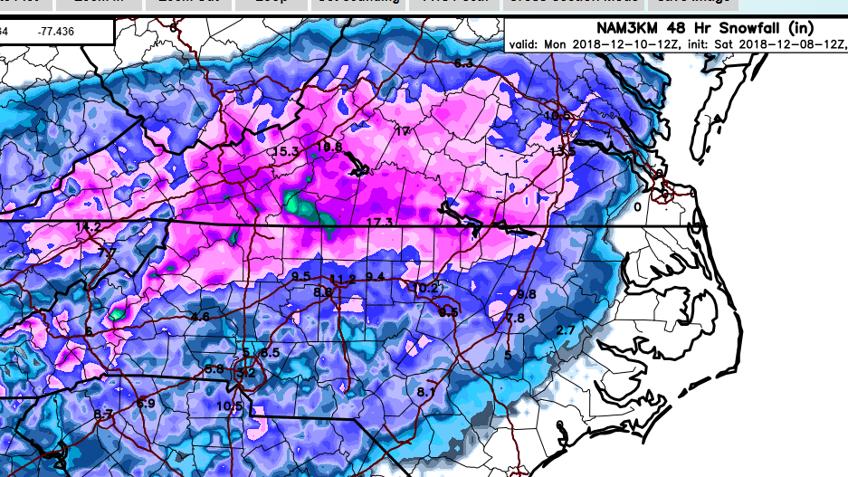
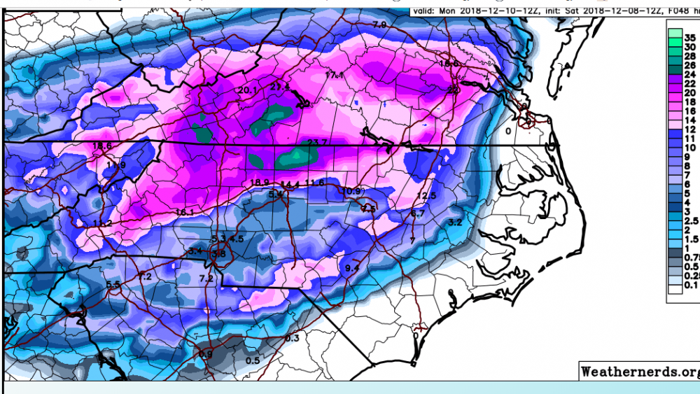
3K and 12K NAM respectively:
-
I'm riding the 12Z HRRR until it tells me otherwise:
-
3K NAM much more of a warm nose up into the Triad. A lot of sleet after about 15Z.
-
10 of the SREF members are between 12-17" for GSO. This is a big jump.