Spartman
-
Posts
1,039 -
Joined
-
Last visited
Content Type
Profiles
Blogs
Forums
American Weather
Media Demo
Store
Gallery
Everything posted by Spartman
-
Not only a September ending with below-normal temperatures is overdue, but a September without a 90 is also overdue. The last time DAY went without a 90-degree day in September was in 2012. With also a wet start to the month expected, Septembers 2011 and 2012 would be matching analogs.
-
Made it to 91 today, the first 90-degree day in nearly a month. Have one more shot at hitting 90 again tomorrow. It's not going to be much of the heatwave that was expected this week. August 2013 seems to be a matching analog for this now.
-
89'd today, highest temperature for this month.
-
Looks like we're going to get an early Fall this year.
-
Heading into the long range, Indianapolis and Dayton are some of those areas that very well usher in September without any 90s this month since late July. The last time Indianapolis didn't reach 90 in August was in 2015 while the last time Dayton didn't was in 2017.
-
Already wetter than normal for this August as of Friday. The current rainfall total for this month is at 3.14 inches.
-
Topped out at 88. Likely going to be the highest it's going to get for this month, even based on one of Judah's tweets. The end of today's 18z GFS run shows highs in the upper-50s on the 29th, but it would be an easy toss for that run. Neither Dayton or Columbus have never had a day when high temperatures failed to even reach 60 degrees in August since the record all-time lowest daily maximum temperature was 60 degrees on August 30, 1915 at those two climate sites. Cincinnati, on the other hand, has only once failed to reach even 60 degrees with the all-time lowest daily maximum August temperature of 58 degrees on August 30, 1915.
-
Again, another day temps underperformed. Hit 87 again today with the forecast high being 88. So far, 87 is the highest temperature reached this month, currently tying the coldest August maximum temperature set back in 2015 and 1915. TWC is now hinting a day with highs in the mid-70s earlier next week.
-
The 00z Euro is hinting a cutoff low by the upcoming weekend. The latest Euro is even showing a blocking pattern to follow early next week
-
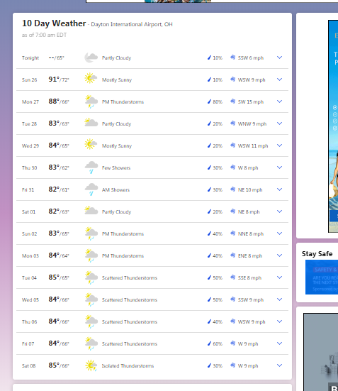
Temps underperformed again, only hitting 87 with today's forecasted high of 89 by the NWS and the NBM models. If the endless stretch of underperforming high temperatures keep continuing, we may very well get an early Fall this year. Looks like it would be the highest you would get for this month. August is 100% done. If there's another real chance of hitting 90 again this year, it wouldn't be until sometime in September. NWS caved to TWC today, regarding tomorrow's forecast high. NWS and TWC both say 88. Highs mainly in the mid-80s for the upcoming week. TWC is even hinting at highs in the lower 80s and lows in the upper 50s to lower 60s taking place in just over a week from now, correlating to CPC's 6-10 day and 8-14 day outlooks.
-
Again, another day in a row temps underperformed. Only reached 83 with the forecast high of 86, even on a mostly sunny day. Yesterday, temps underperformed by only hitting 81 with that forecast high for yesterday being 83. The NBM model has been running a bit too warm lately. #FallIsComing Bring on the August 2017, 2015, 2013, 2009, 2004, 2000, 1997, and 1992 analogs. NWS is hinting at only one chance at hitting 90 early next week, but TWC has none. If TWC nails this, and based on the models, we may be writing off August unless we repeat August 2013 when the heat did not come back until near the end of that month.
-
-
Looking more of a fall-like frontal system happening today. Going to end up being the first day in over a month to fail to reach 80 degrees.
-
Yesterday's 6z, 12z, and 18z GFS runs were advertising a fall-like storm system during the first weekend of August with at least one day with highs in the mid-to-upper 60s.
-
Heat wave cancel. 89'd everywhere today. Only expecting 1 or 2 chances of hitting 90 over the next few days. After that, no more in the foreseeable future.
-
It's over. Got 89'd after a 9-day streak.
-
Hit 90 before the first round of storms came. Received 1.11" of rain so far today. May very well break the daily maximum rainfall record of 1.62" set in 1942.
-
Hit 90 for the first time this year.
-
Spring/Summer 2020 Medium & Long Range Discussion
Spartman replied to Geoboy645's topic in Lakes/Ohio Valley
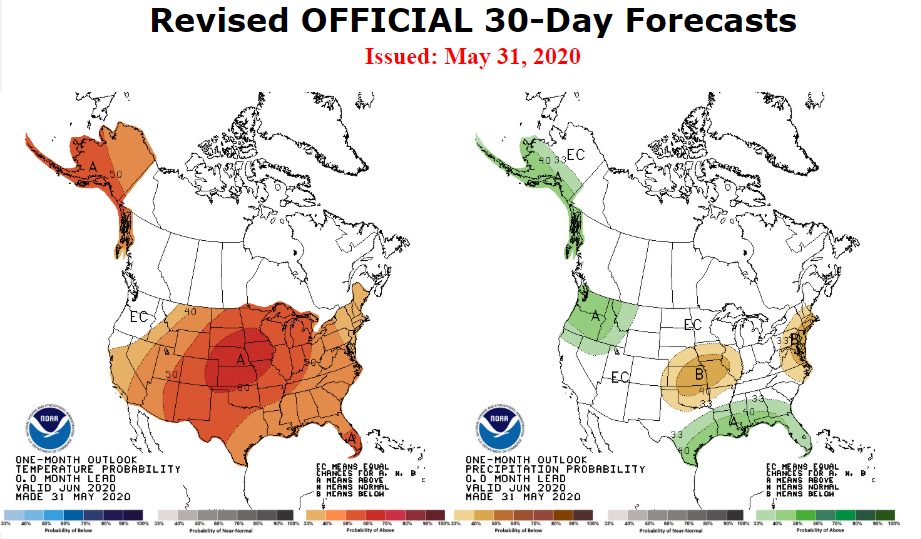
If the Euro holds, we'll be writing off this Month and even July. -
Topped out at 88, highest it'll get for this month.
-
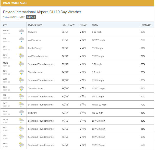
Even TWC is hinting almost no dry days the rest of the month heading into June. This was the 11th day with measurable precipitation for Cincinnati, the 12th day with measurable precipitation for Dayton, and the 13th day with measurable precipitation for Columbus. Cincinnati's record for the most number of days with measurable precipitation in May is 22 days in May 1892. Dayton's record for the most number of days with measurable precipitation in May is 21 days in May 2003. Columbus' record for the most number of days with measurable precipitation in May is 22 days in May 2004, which is also the all-time record for the most number of days with measurable precipitation in a calendar month. The all-time record for the most number of days with measurable precipitation in a calendar month for both Cincinnati and Dayton is 23 days in July 1992.
-
May 13-19 Severe/Heavy Rain threats
Spartman replied to Tim from Springfield (IL)'s topic in Lakes/Ohio Valley
Tweet from yesterday: -
Even in the long range, looks like the second half of this May is going to be a washout.
-
Spring/Summer 2020 Medium & Long Range Discussion
Spartman replied to Geoboy645's topic in Lakes/Ohio Valley
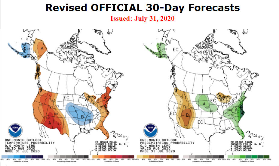
If not July. Just one of those years.