

dilly84
-
Posts
4,076 -
Joined
-
Last visited
Content Type
Profiles
Blogs
Forums
American Weather
Media Demo
Store
Gallery
Everything posted by dilly84
-
0z Hrrr has me switching to snow at 6am see how accurate that is. I'm also curious if it'll be one of those deals where it's snows for an hour then sleets for an hour then snows etc.
-
I have cleveland in 12-18"
-
Who's staying up to track it? I'll be up til at least 3a
-
No but it's still a weak system with a pressing high. Idk. We'll see. I'm sticking with my sleet line lol
-
My map was for 6-8 for us.
-
I know, but we've never gotten to the modeled temps today, and I just dont think that waa is string enough to overcome that cold front. I think it'll be close and the sleet line will be around eastern coshocton/Guernsey county and southwest from there.
-
It was better than 12z.
-
21z rap and 18z gfs both showing over a foot now.
-
Only model to be consistent. I went with a lowered version of the gfs. Wont be surprised if it's not more. We've not even gotten close to the modeled high.
-
Sref plumes have several over 8"
-
Nam has finally came around. What is cod?
-
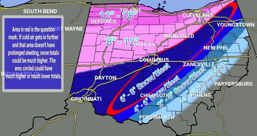
My call
-
I dont care to get dragged lol
-
2hrs late on that one lol
-
The heavy amount at bottom isn't taking into account sleet.
-
Rap model has the freezing rain/snow line running through Guernsey County. So quite a bit se of many others.
-
Gfs and ukie have been the only 2 models that's remained consistent for the last 3 days. I think I'm gonna ride with the gfs.
-
Shouldn't need dynamic cooling. That high should have no issue getting cold air in against the weak low. Low has perfect placement, and the setup in general is perfect. Each meso run creeps further southeast. Idk what I'm going with yet. I'm watching a bit more than doing my final.
-
Rgem definitely moved south this run. Still puts us on the line of sleetfest. A line from stark to franklin.
-
6z Nam small bump south. 6z HRRR didn't look good.
-
Canadian still horrible. Worst modeling I've seen. There's not much consensus in any of em.
-
Ashamed to admit I just use accuwx's
-
Again, perfect placement. Low through Eastern KY to near Morgantown or so, yet keeps us sleet the entire time. Sigh. It appears no model is going to cave, so apparently it's take your pick. Unless... GFS caves 0z.
-
Low was doing all kinds of weird stuff but was still in a good spot when it wasn't moving all around.
-
Looks the same in the end.


