dilly84
-
Posts
4,076 -
Joined
-
Last visited
Content Type
Profiles
Blogs
Forums
American Weather
Media Demo
Store
Gallery
Everything posted by dilly84
-
Something that isn't being discussed much is that many models are showing windchills of up to -30 in the wake of the storm. So throwing this up here
-
Same here. 3-7" playing it safe with the wide spread amount
-
18z NAM doesn't look bad, never really deepens but gives a solid 8"
-
Yea you're correct. Wasn't taking into account the Friday. But that also means euro is giving from i70 west basically 2-3" Saturday
-
Yea but you're like me. I'd rather take the risk of amped up than not at all. In your case, you look good according to wxbell snow map for close to a foot. I'd take that in a heartbeat. The older I get the less I could care about 4 or 5 inches lol.
-
I'm different lol. It gives me around 5". I'd rather have nothing. Give me something big with this setup or nothing at all. 4-5" is what I call hassle snow. Enough to have to go shovel but nothing to really be impressed with
-
I mean from the 10-12" it quickly drops off.
-
Take your pick. 3 models epic storm, euro, decent but nothing special.
-
Edit:buckeye is right about 25: miles south of last nights. Nearly takes cmh out of heavy snow. Takes me out of it for sure. Line from Cincinnati to Pitt down to Athens 10-12". North of that it quickly drops off.
-
Hr 84 has a 997mb low in south central TN. Definitely should be a good run for us for sure.
-
As well as the ptype issues considering most models has the low from tn/ky to wv while redeveloping. Can't say I've seen that too often
-
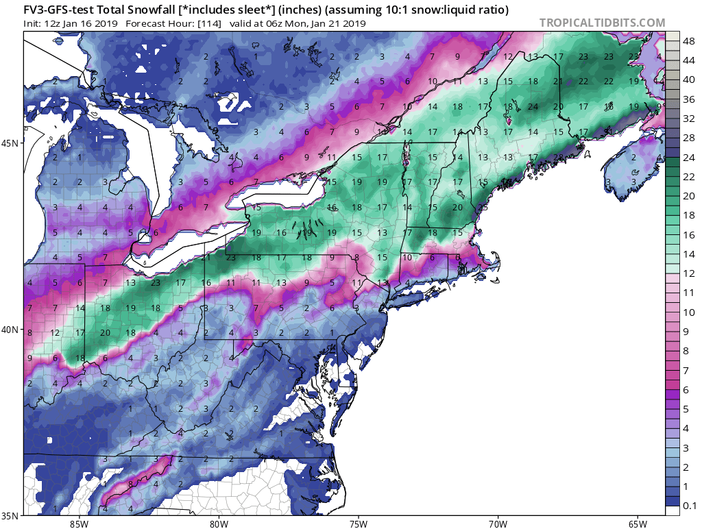
FV3 puts the hammer down fellas.

-
I said tomorrow's 12z runs SHOULD start to have the general track. However, today's runs have been great if you're in the i70 corridor.
-
It just updated. Low goes from Central ky to around Athens. Just need 25 miles SE and we're golden with the gem
-
What site are you using that models update so fast. Using tidbits to hr 66 looks like it may be another perfect track for us.
-
GFS same scenario. Great track. Ptypes screwed up. Has the low go from TN to eastern Kentucky but shows zr and rain for i70 south. Guess we're throwing out the ptype maps
-
Thursday system is a tad weaker and a tick south on GFS, could spell a bit stronger weekend system.
-
Most aren't making sense to me though. Perfect track but ptypes messed up on all of em. It takes the low from southern ky to WV, so why it wouldn't be laying down 12" of snow for us I don't understand.
-
Icon looks nice. Real nice thunderstorms across central Ohio all the way past Mansfield.
-
NAM still digging down into Mexico. Maybe it won't be a bad thing, should definitely be juicier I'd think lol.
-
Euro perfect track for us central Ohio crew.
-
Yea I was. Was looking at day 4 type. Mean looks like operational. Many have it well north of i70 though. Idk tonight's runs were a mess, and I agree with you its nonsense to have had the consensus we've had for days for any consensus to fall apart 4 days out.
-
Idk. Look north to me. Quite a few have most of Ohio with rain
-
Yea well, still waiting on fv3 after 90hrs. May still do okay.
-
Fv3 looks a tick south but the rain is further north. Makes no sense to me. What a mess on the 0z runs