

dilly84
-
Posts
4,076 -
Joined
-
Last visited
Content Type
Profiles
Blogs
Forums
American Weather
Media Demo
Store
Gallery
Everything posted by dilly84
-
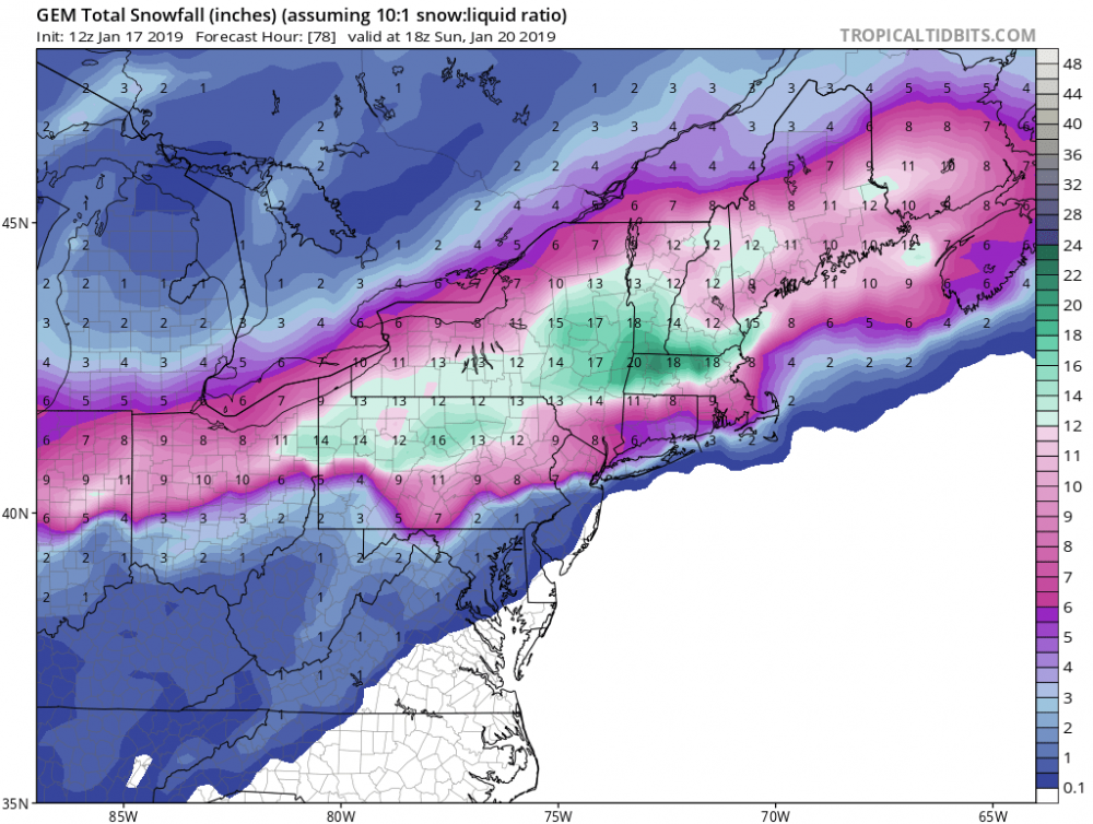
The low made it further north into WV, but not really any further north into Ohio. Just brings the rain maybe 20 miles further north. Snow location is pretty much the same just less moisture. Still has a swath of 10" todays: last nights

-
CLE did the same lol
-
Icon highest snow total in Ohio is 6". That also makes little sense
-
Yea and seems to be lacking moisture I thought.
-
Yep edited. Its actually a better run.
-
12z gfs looks further north. Dont appear its craving today. Edit: actually a better run... or not.. seems to be lacking qpf considering the strength.
-
Apparently the snow maps dont wanna load for the icon either....
-
I noticed that. Doesn't make much sense from 60-66 lol. Kinda just redevelops twice maybe? Lol
-
Still brings the r/s line up to cmh. I'd assume, because like the NAM, it reaches 996mb. But the surface low doesn't get as far north as it did on the nam. So id take the rs line 25 miles southeast due to icon being icon.
-
Yes, but the 3k was about 2mb weaker and the low is in south central KY. Because of that I'd guess the 12k was overly ramped. BUT, I'd rather have the 12k where it is 3 days out than the low to be cutting through Columbus lol
-
any predictions on the gfs? Does it cave this afternoon or does it stay north?
-
Im not too concerned with the NAM. Biggest thing is that it was significantly stronger. A couple mb higher and r/s line is less likely to reach i70. Still appeared to be near a perfect run. And the storm is being sampled now. Hope we dont see too many wobbles after today's runs.
-
People ask me all the time why I didnt go to meteorology school, I always tell them look at the Mets that struggle to find jobs as it is. Great field if you can find work in it. Unfortunately its not an easy task.
-
6z was pretty much perfect. I kinda like 12z better. More risk better rewards lol
-
It definitely puts you on the line, but it does the same with Columbus and Cincinnati here as well.
-
6z
-
Makes it to southern Franklin and licking. That's it.
-
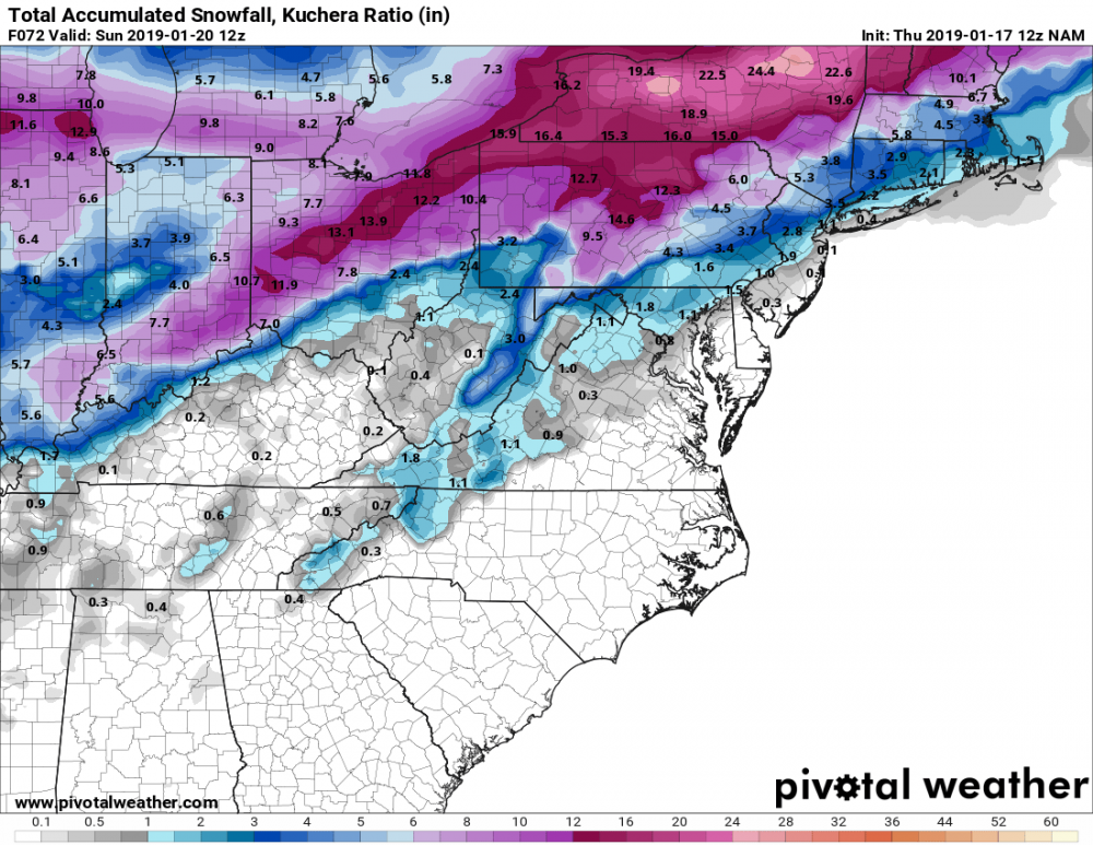
Not much. .2 for you, but had you with a brief period of rain. So the strength got the rain snow line to licking county never any further north as noted by the snow total map I'll post.
-
Perfect track. Low goes from central KY to the tip of southern Ohio then over to near Morgantown. Can't ask for a better run than that.
-
Puts a nice band of 10-12" all across Ohio from Cincinnati to Steubenville and north. Curious though about ratios with that cold air coming in.
-
You work for any field offices?
-
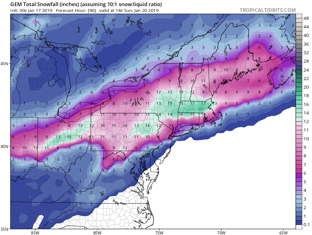
Very tiny tick. But the rain/snow line makes it closer to i70 but never gets there. Exhale lol. It's also much stronger. 996mb in central KY this run compared to 1001mb on 6z
-
12z NAM is around 25 miles south with the surface low at 48. Good sign. Rather it be a tick south than moving north.
-
I think we're all collectively holding our breaths for today's runs knowing the storm is now being sampled lol. I know I'm a tad nervous.
-
6z nam sure is a thing of beauty
.thumb.png.c6376782112b472b4aca1cac55d0c230.png)


.png.42f7f32b6a8b87f4eb1cd54e34a40a0b.png)