The 4 Seasons
-
Posts
7,985 -
Joined
-
Last visited
Content Type
Profiles
Blogs
Forums
American Weather
Media Demo
Store
Gallery
Everything posted by The 4 Seasons
-
i think i've heard that figure skater analogy over 100 times in college met classes. lives in my head rent free
-
probably the first solid significant (>0.75") rainer all winter, at least since Jan 1. Dec had a couple.
-
any reports in N MA? nothing is plotted yet on the interactive map...im guessing there was about 1-3 N of RT2?
-
no. 18.
-
I'm sayin'
-
Get in the Basement!
-
Never never had a chance here. Always looked like mostly a mixed mess nop with a couple/few well north
-
That's our chance, mid month time period. After that it starts getting really dicey climo wise around our area
-
Tell me about it
-
Thrilling stuff lmk how much you get
-
-
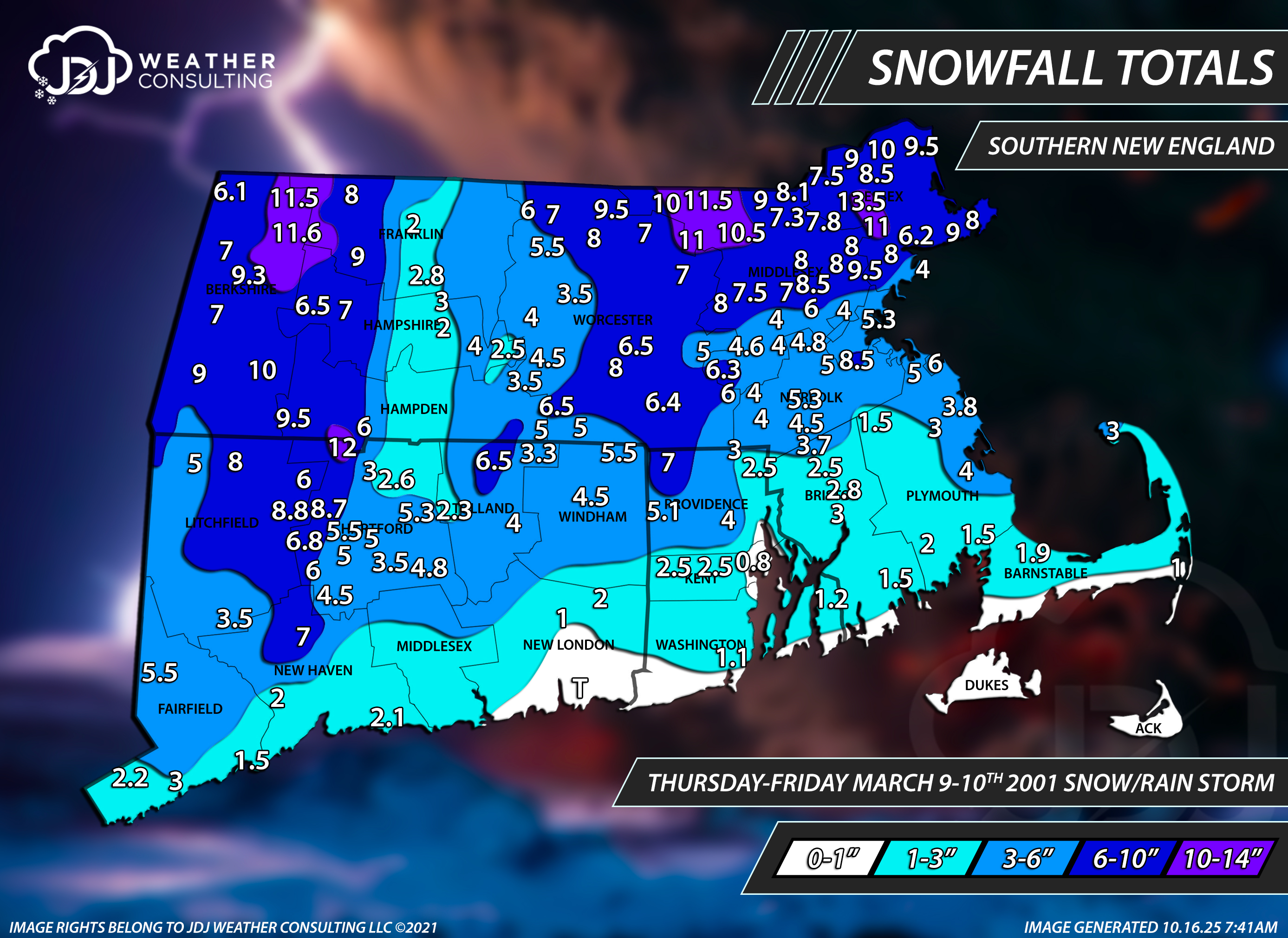
https://www.jdjweatherconsulting.com/mar-9-10-2001

-
OKX Upton COOP must not because they are always coming in low like central park. look at this event they are the only <20 around them so i had to put a hole there.
-
He said to Commercial Traffic. Meaning out of state trucks couldn't pass through the state, commercial vehicles/tractor trailers were banned from the highway. I remember this specifically happening for this storm its happened many times in CT, no commercial traffic so out of state trucks had to turn around or get pulled over and fined.
-
yea that sounds about right, for me it was always the (top end +200% of bottom) or X-2X. and cap it around 12. I see weird ranges like 4-12" all the time but its usually in high elevation change situations. The hysteria was pretty off the charts, even for back then. Imagine if that was 2026.. based on strictly snowfall forecasts from the NWS it actually wasn't a bust here since the WSW/Zones were like 10-18 for coastal CT and 13-23 for interior southern zones.
-
It was all a dream, i used to read Word Up! magazine
-
1-3 FEET of accumulation is such a weird and kind of a cop out range if you think about it. 12-36". Having a range where your highest end is double the lowest end is the most you should do (with the exception being 1-3") other than that the high end of the range should be 200% or less of the bottom. 12-36" is kinda ridiculous. I saw BOX did 20-36" for the worcester hills. just my take
-
Yeah i remember TWC graphics going from an all snow icon to the wintry mix icon knew we were about to get screwed. But it wasn't that bad after all. Kocin was nervous as hell on air. Even with the "meh" snowfall totals and shitty accumulations near the coast it was still truly a beast superstorm that completely stalled for days
-
lol ive never seen 20" from a single storm (except 96 but i dont remember that) i thoroughly enjoyed that storm, despite only getting 16" ish inches. And the fact we got a full on snow and sleet blizzard for nearly 65 hours was pretty unique and memorable. Plus we got like 3 days off from school which never happened from a snowstorm. It was always a day off and maybe a delay the second if you're lucky. I do feel like if that repeated in 2026 there would be a lot of meltdowns on this forum. Not knowing anything about models and forecasting back then i think saved me a bit from being overly invested in huge amounts.
-
Just like Dec 2020.
-
im doubting they ever will... i always wondered if Mar 2023 should be on there too, as like a Cat 1. I know it was interior but it was an absolute nuke with 30-45" amounts. None of the big cities really got in on that but niether did Mar 1-3, 2018 and that is a NESIS level event. though im way more confident that Jan 2026 should def be on there than that storm
-
The V5 is much more tame and its going operational soon to replace the current one
-
its weighs a lot of the hi res garbage models like WRFs, SREFs, HIRESW, 3K, RAP etc and those were super amped and inside BM for a while pummeling all of SNE so it was no surprise it was very high until the end. It was also way too high for Jan 25-26 until the end it came to reality, kept showing 20-30 for most of CT with ridiculous ratios
-
definitely for there and NYC, dont even mention it to them. @MJO812favorite storm ever! he might block me now
-
they love the NBM, and guess what the NBM looks like that, so no surprise i just posted your fav storm btw, a new thread