The 4 Seasons
-
Posts
7,985 -
Joined
-
Last visited
Content Type
Profiles
Blogs
Forums
American Weather
Media Demo
Store
Gallery
Everything posted by The 4 Seasons
-
Yeah and don't forget 21" during the blizzard
-
Thanks lotta strange names in there i don't recognize..16 years ago
-
https://www.jdjweatherconsulting.com/storm-archive
-
That was the only widespread adv snowfall that season
-
? It's there not sure how you could miss it It's in the main archive and all the snowfall maps pages
-
I did. I used that as a guide back to 2008 and also used the F6 for EWR BDR BDL and ORH. And then checked pns and coop/cocorahs for those dates that showed snow and my memory as well. Oh and Ray's winter storm archive I think i just didn't include it in the main archive bc it didn't affect CT with any snow >3". I am going back and filling in all the missing storms in the SNE snowfall maps pages (every N MA, E MA, S NJ only storm). There's a lot.
-
Yup looks like it was separated into two parts on the 20-21st and the 23rd. The pns lists it as two separate events even though it was part of the same system. https://arctic.som.ou.edu/tburg/products/realtime/models/?model=era5&base=ptype&background=plain&state=states_brown&country=countries_brown&proj=conus&archive=false&run=2010121100
-
Maybe they moved from Canada and think it's CM? I don't see any other way you come up with that number
-
Didn't realize i missed a very large coastal storm that clipped SE MA before Boxing Day 2010. I didn't know about that one. I'll have to do that one and add it
-
Looks like a general C-2 for most of franklin, worcester, middlesex and essex counties
-
After thinking about it I don't think we've had a winter this well rounded with cold, snow pack and storms every month since 95-96. Maybe 10-11 or 13-14 but even those didn't have a march... we'll see how march works out this time. I guess 02-03 was wall to wall but not this much snow pack and Jan was dead
-
What did you end up getting? This event always looked like dung to me the little I delved into it
-
I'd sign in second for that. 8-10" storm in March would make this winter an easy A. 4 months in a row with a warning event. It's not like it's historic for SE mass, just more. I don't care what my neighbors get as long as I'm expecting it.
-
Lmao 21-24" MEAN on the geps?? What's wxbell like 6"? Weenievista
-
Once i get all these for the season for SNE and tri state i can plot them on a map.
-
yea i wont be using that station, i knew after the blizzard it was terrible. Most of these other ones seem reasonable so far.
-
I'm fully caught up on the archive for this current season with 12 3"+ events and every single event mapped out in the snowfall maps sections if it didn't make the main archive. I set up a dedicated page for Winter 25-26. The SNE snowfall maps page has 23 events so far that required a map (>1" for an area) Also all the season to date stuff is on that page as well, probably do one more final update to that in April or early May. https://www.jdjweatherconsulting.com/winter-25-26
-
i can see being a few tenths off or a few inches during the blizzard but how they came up with 21 when surrounding areas had like 10-15 still baffles me. Also in this event, if there was say 1.5-2, how do you even get close to 4? I have someone like that in my town that'll report nearly 1.5X to double me sometimes.
-
which one
-
i missed that reference
-
it's the same cocorahs station that reported 21" in the blizzard that i tossed violently away. All the surrounding totals were far less. So that seems like its possibly a slanter/over measurer. Of course thats the highest report so far in that area. So i woulnd't trust it personally...
-
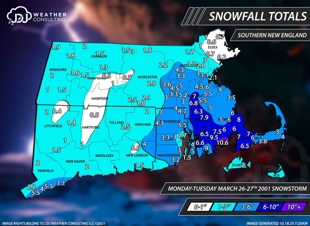
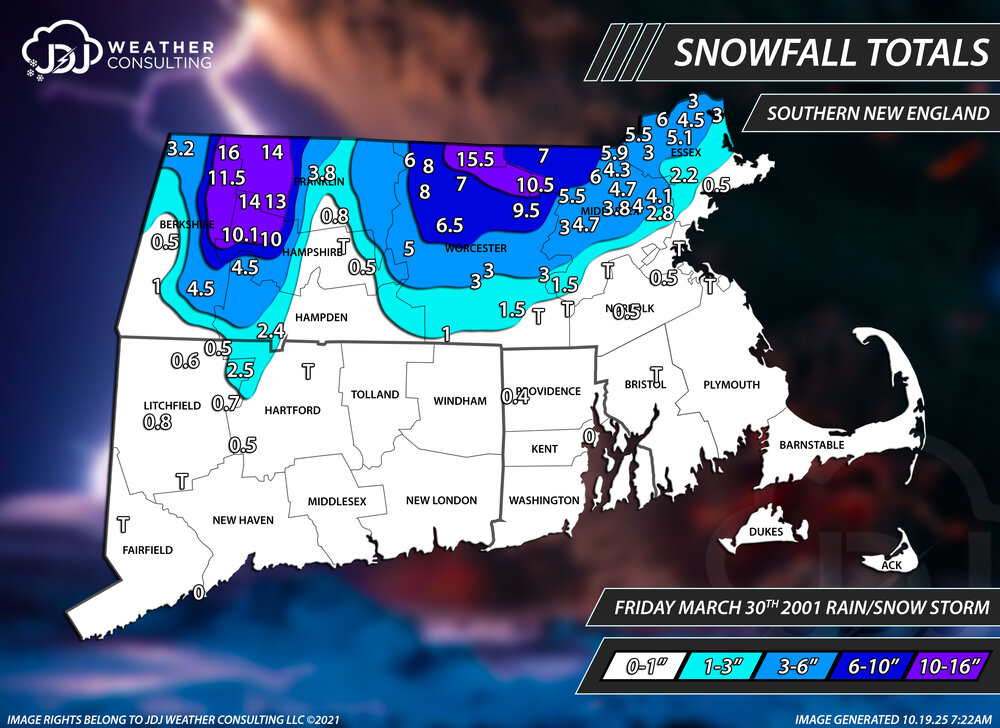
What was that late March storm like, i barely remember anything about it here but it looks like it whacked the SE MA area pretty good? I remember you said March went gangbusters in another thread a while ago. I counted 4 storms for March 2001 that i could find, i dont think i missed any bc i look over all the PNS and F6 data. There was obviously March 4-6th, and then March 9-10th, March 26-27th and March 30th
-
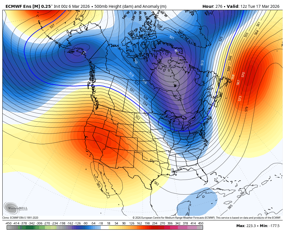
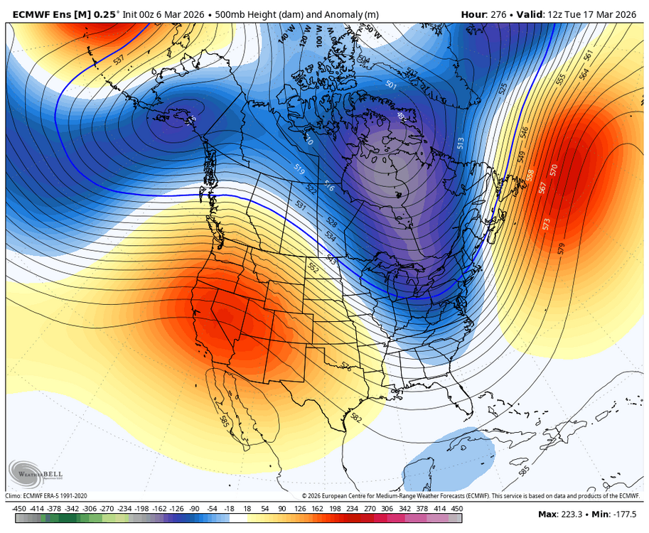
Weathergeek has some nice charts he can make for you. But yea the Euro/EPS/AI has a nice look with wstrn ridge around the 16-19th time period. GEFS is more zonal and hasn't been that great looking overall compared to the EPS/AIEPS. Thats right about the time period that storm pops on the 00Z EC OP. Good solid HP to our north with a lot of cold air to work with as well. GEPS is definitely more euro like
-
Andover 4.0 Ashburnham 3.2 Lowell 1.0 Westminster 0.8
-
never. ineedsnow would lose his shit. plus it's adorable. this one on the other hand...