The 4 Seasons
-
Posts
6,342 -
Joined
-
Last visited
Content Type
Profiles
Blogs
Forums
American Weather
Media Demo
Store
Gallery
Everything posted by The 4 Seasons
-
what in the world does no access to PR/OT mean?
-
Totally agree. But with Super Dark Mode you can just click the extension button to swap it back and forth between light and dark mode. So when you go to amwx just click the button for dark and then click it again when you want it off. Its pretty much the same as a site specific, just with the added step of clicking the extension button.
-
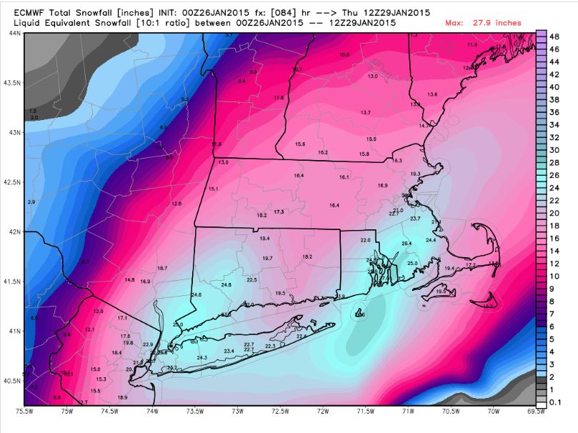
Brutal... That BOX map was pretty insane. Forecasting a widespread 27-40" over CT and MA, a much larger area than Feb 2013 PDII


-
Yeah, i would like native support as well. For now i use an extension called Super Dark Mode in the chrome web store for Brave. There's a bunch of them in there. It's far from perfect and there can be some weird formatting issues but you can easily toggle it on and off.


-
Kind of reminds me of the Oct 11 stat in New England. More snow at climo sites from that one storm then all the years combined, on all the dates added together through Oct 30th.
-
Dr. Dews, he's just here to "learn and post obs" You have him blocked but he still lives in your head rent free. let it go, he is a troll you're right but whats the #1 rule on the internet? dont feed the trolls. its just words on a screen and emojis. let him be.
-
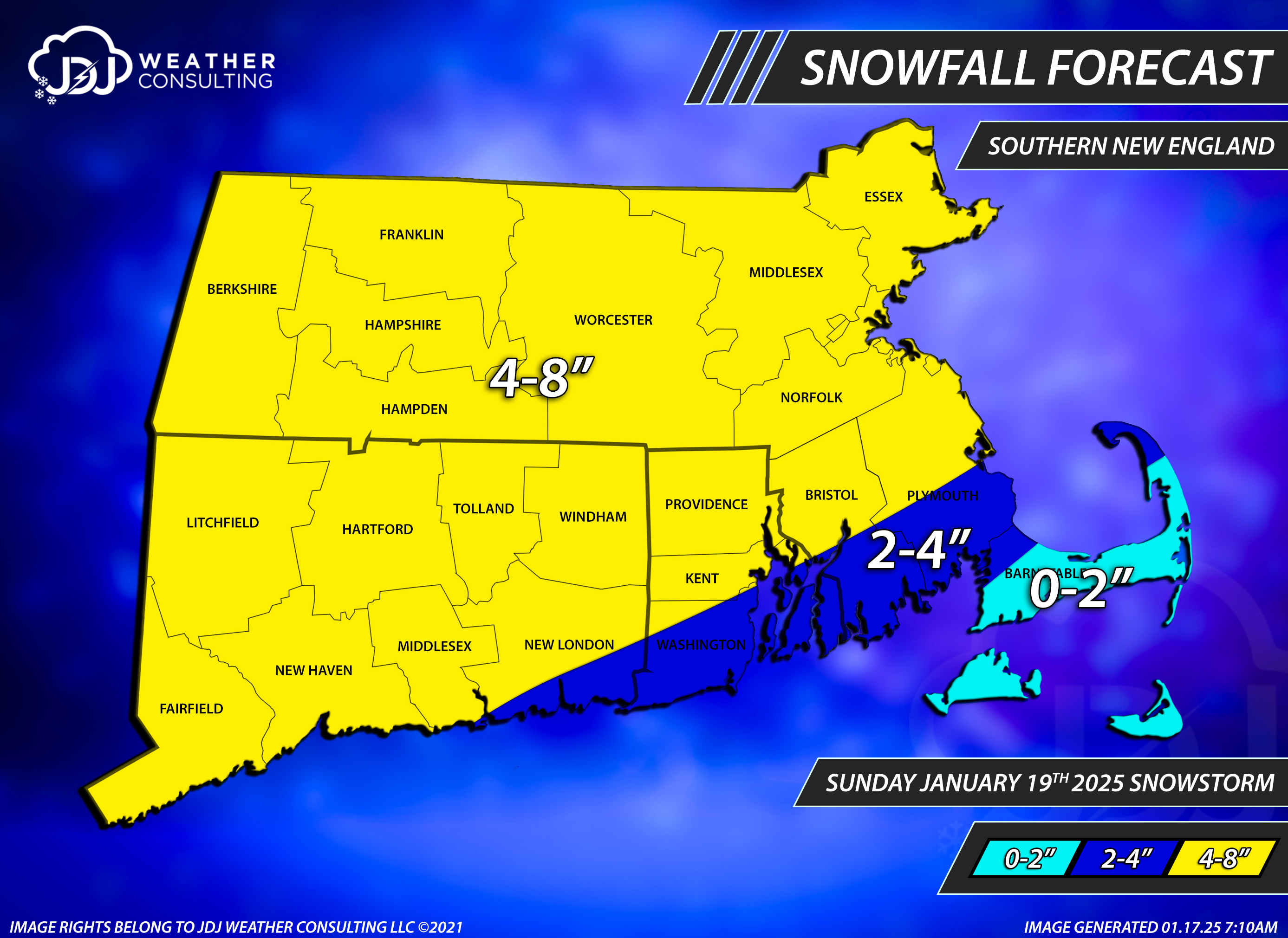
 The last map i saw from you was 5-10 across the state and 4-8 SE corner? That was pretty bad. For CT alone id give the grade a D/D+. Warnings were probably not even waranted anywhere in CT, advisories would have done it. It was pretty a much a 3-6 statewide, 1-3 south and SE CT and 0-1 far SE corner and shore.
 -
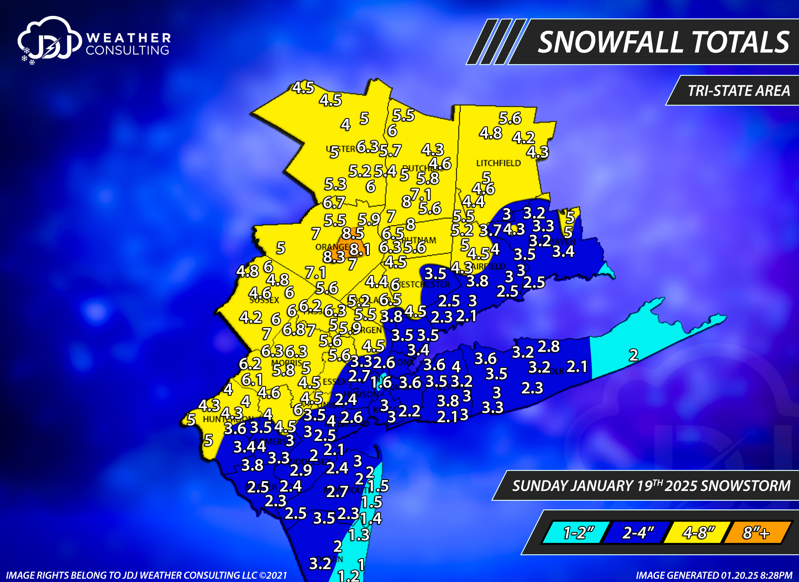
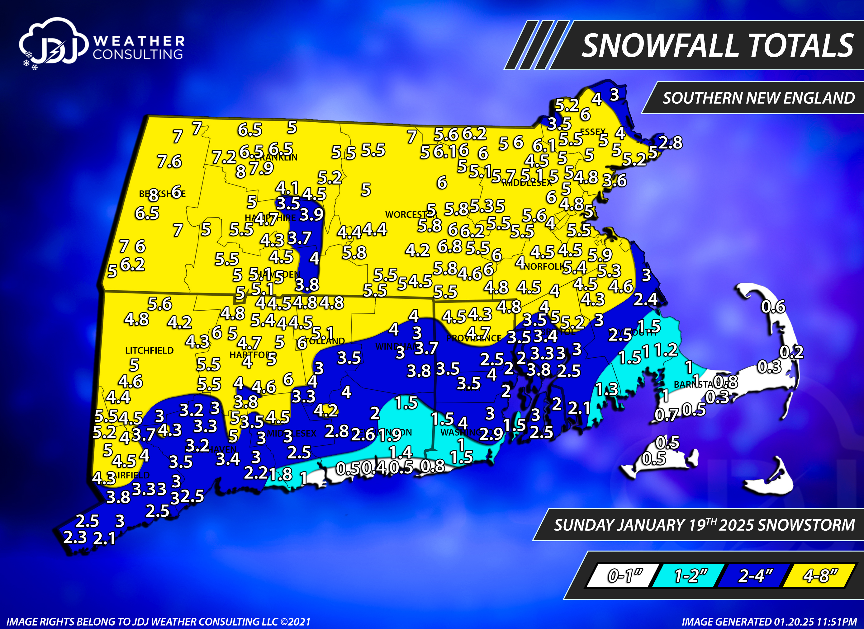
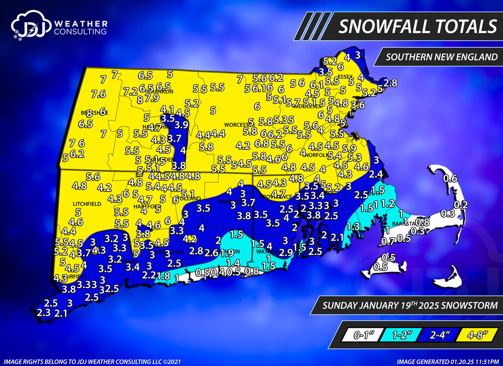
Snowfall totals maps for CT, SNE and the Tri-state area. Reports are from here, COOP, CoCoRaHs and NWS PNS. I think the forecast overall was OK. Most of the area fell within the 4-8" except for the southern portion which a good deal of the population lives. I can't give it a great grade but at the same time it was far from a bust overall. https://www.jdjweatherconsulting.com/past-storms-24-25 Grade: C


-
Yep. I noticed that and was just going to leave it out, but its an official OB so i included it but im sure its too low
-
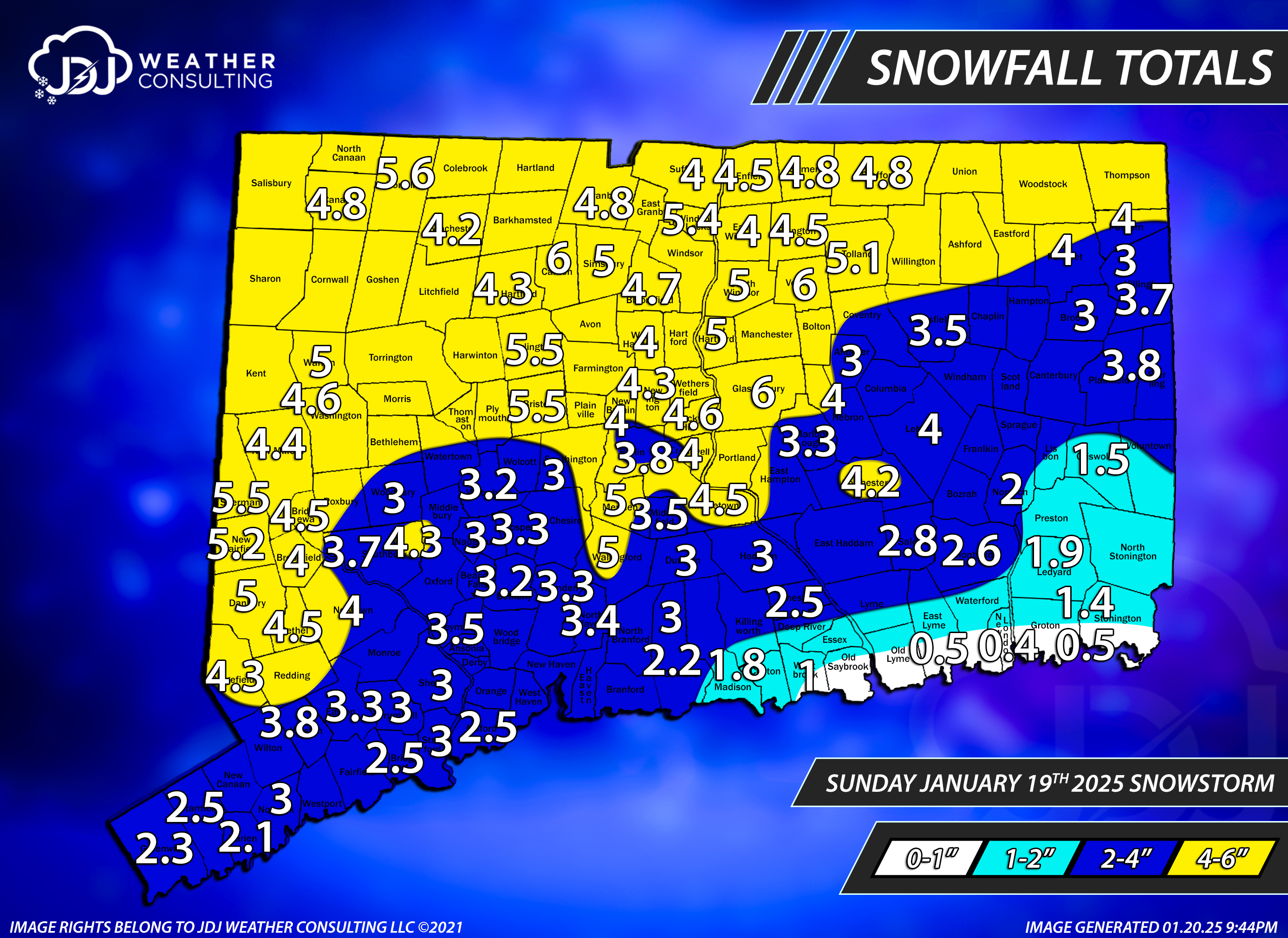
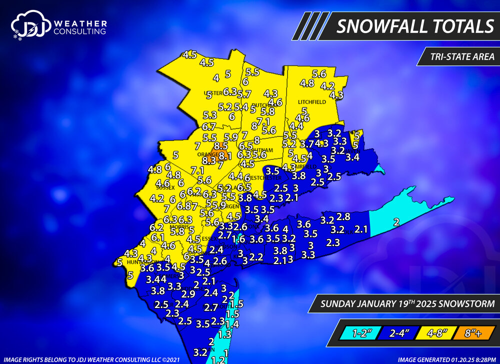
Tri-state snowfall totals for this event. Reports from COOP, CoCoRaHs, and NWS PNS reports.
-
Finally. A KU. Maybe in the 2020s we just have to start measuring in cm. You got over 12! congrats
-
As underwhelming as this was...and not by much, just under 4" on a 4-8FX expectation. It's still a welcome and pleasant surprise given the pretty intense cold thats coming to keep all the snow around coupled with the fact this looked like a nothing burger-whiff 4 or 5 days ago. If anyone has an final totals for the event anywhere let me know. ill be doing maps for the tri-state area, CT and SNE, thanks.
-
3.2 but still snowing lightly, maybe a couple more tenths. still well below 10" on the season.
-
what do you think youll end up with
-
Heavy snow here, pounding dem aggies too. 0.7" in 20 minutes
-
I dont see how you verify 4-8, the back end is fast approaching you
-
Snow is getting heavy in south/SW CT. Large dendrites piling up quickly, i got an inch just like that. Wind is picking up as well.
-
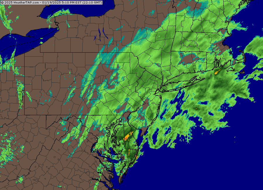
Running 72 hour snowfall map, you can use the slider to adjust time increments https://www.weather.gov/source/crh/snowmap.html Snowfall analysis map, uses those totals to create a graphical display of contours of snowfall without individual totals, usually lags behind a little bit https://www.weather.gov/crh/snowfall Gridded snowfall analysis from NOHRSC, you can see 6-72 hours here as well and seasonal back to 2008 https://www.nohrsc.noaa.gov/snowfall/ On weathertap? if you are on the radar home page just click on the northeast and then click again and youll get that zoom. use the left side panel to pan to adjcent images. ill text you shortly but here is the exact link https://www.weathertap.com/radar/state/nj/normal Totals really starting to pile up in NJ
-
weathertap you have to pay for it
-
Some pretty good totals so far in NNJ already in the 3-5 range
-
Yeah i thought the AI def did better than the OP was pretty consistent all along with the track and qpf...for the most part
-
The black ice is crazy out there this morning. Even main roads had ice, i saw cars sliding everywhere, it was bad
-
I saw, good to see. The NAMs and HRRR are pretty paltry.