The 4 Seasons
-
Posts
6,363 -
Joined
-
Last visited
Content Type
Profiles
Blogs
Forums
American Weather
Media Demo
Store
Gallery
Everything posted by The 4 Seasons
-

Winter 2024-2025 All Tri-State Snowfall Totals Maps
The 4 Seasons replied to The 4 Seasons's topic in New York City Metro
If anyone has any seasonal snowfall totals that have changed since March 10th let me know what your current season snowfall total is. Especially looking for anyone in Sussex, Orange, Putnam, Rockland, Westchester, Dutchess and Ulster counties. I'll be doing a final season snowfall map probably this week. -
Winter 2024-2025 All Tri-State Snowfall Totals Maps
The 4 Seasons replied to The 4 Seasons's topic in New York City Metro
No probably just 2000. But that's already up on the historical section with maps https://www.jdjweatherconsulting.com/jan-1996 -
Winter 2024-2025 All Tri-State Snowfall Totals Maps
The 4 Seasons replied to The 4 Seasons's topic in New York City Metro
Yeah his site is really something else. After working on this i have a unique appreciation for how much time went into doing something like that. For example he has 127 storms listed from 1993-2013 and each storm has 15 individual pages for different levels, radar, sfc, etc making for a total of about 1,905 unique web pages. Something like that takes years to put together. Not to mention he did a snowfall map for NJ for every storm. I tried to email him but got no reply, that was about a month ago. I feel like a lot of what is up on his site was done in coordination with someone at the NWS and CIPS because for example, you can't find any of those snow maps on the CIPS site. If i could post all the maps like he did, i would...but every reference link he has up is dead, like every single link. However, what we will have that is different from his site is a full radar loop of the entire event as well as surface and H5 animated loops. Since you're in New Jersey, we do have a tri-state map for every event that covers most of New Jersey. I just finished adding most of the 21-22 season this week. Working on the final event today and then 20-21. -
I remember that day. Serious back door. I dont think ive ever seen mid 30s and mid 80s at the same time in CT, that was wild. We were only in the 50s here with a forecast of 70
-
Made it up to 72 here what a great day easily the best of the year so far. Finally feels like Spring.
-
Phoenicia, NY in ulster county, 830FT. It's a report from COOP
-
thats rough, already 65 here
-
Winter 2024-2025 All Tri-State Snowfall Totals Maps
The 4 Seasons replied to The 4 Seasons's topic in New York City Metro
There is a new Winter Storm Archive i am working on to be an alternative to Ray's Winter Storm Archive that ended at the 2012-2013 season. Right now our site mostly just has snowfall maps and is more focused on CT. With this new archive i will be going backward and creating snowfall maps for every moderate event (3"+) for all of Southern New England and the Tri-State Area. Each page will not only have the snowfall maps but a full radar loop of the entire event, a surface map loop of the Northeast, daily surface weather map loop of the US and a H5 US loop. So far i've completed back to 2021-2022 so you can see the first 4 seasons. I will be working on this continually throughout the spring summer and fall and hopefully get back to 2000 by the start of next season. Check back continually because the site will be updated every week going forward. I'll probably do a post explaining everything and all the changes at the start of the 25-26 season.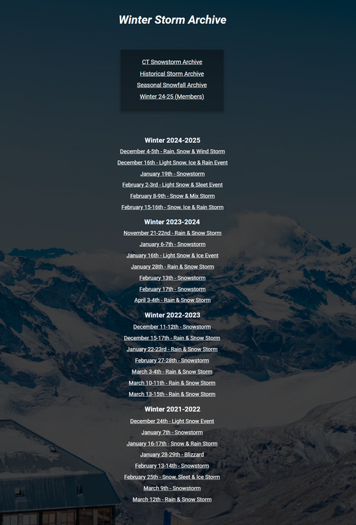
-
and a half inch i saw when i scrolled the pages from Friday night? I didn't see the 1.2 but i saw the 0.5
-
Winter 2024-2025 All Snowfall Totals Maps (CT/SNE)
The 4 Seasons replied to The 4 Seasons's topic in New England
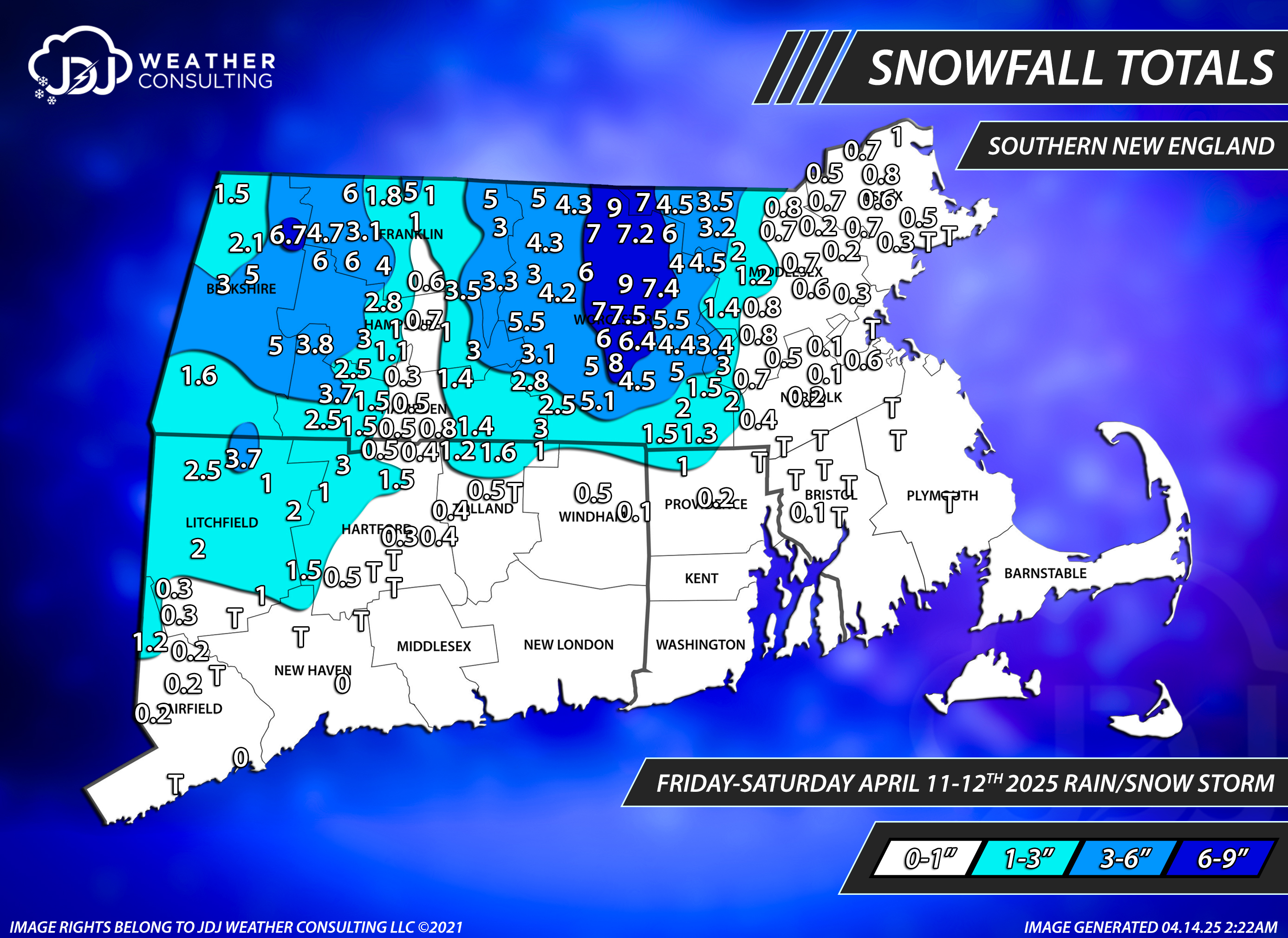
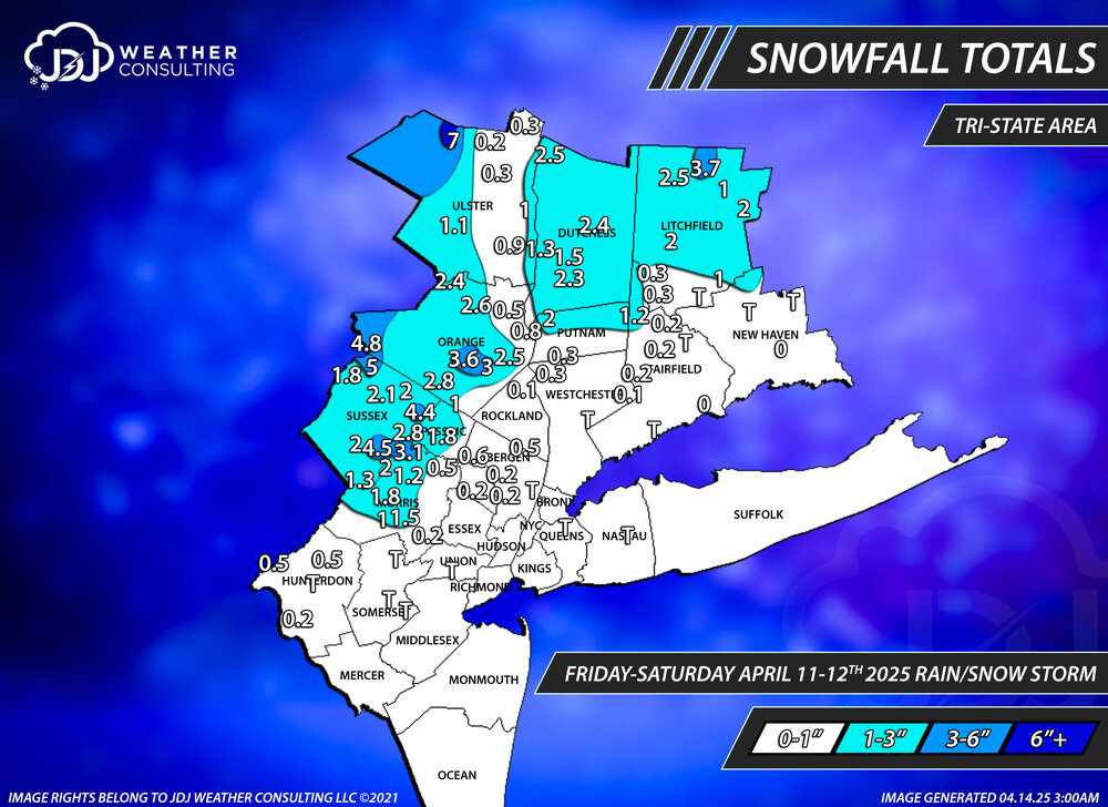
I updated this page to add the Apr 10-11th and Apr 11-12th storms as well as fix some stuff. The latest update to the seasonal snowfall map is there and i will be doing a final update in late April to finish the season off (just in case there is some sneaky elevation event or something). Our website is also update incase these ever get deleted or removed for space. -
Winter 2024-2025 All Tri-State Snowfall Totals Maps
The 4 Seasons replied to The 4 Seasons's topic in New York City Metro
I updated this page with the latest map for April 11-12th and fixed some other stuff. I'll be doing a final seasonal snowfall map for the 24-25 season probably at the end of April just in case there is any more sneaky events. Our website is also updated with all snowfall maps if ever i have to delete these for space. -
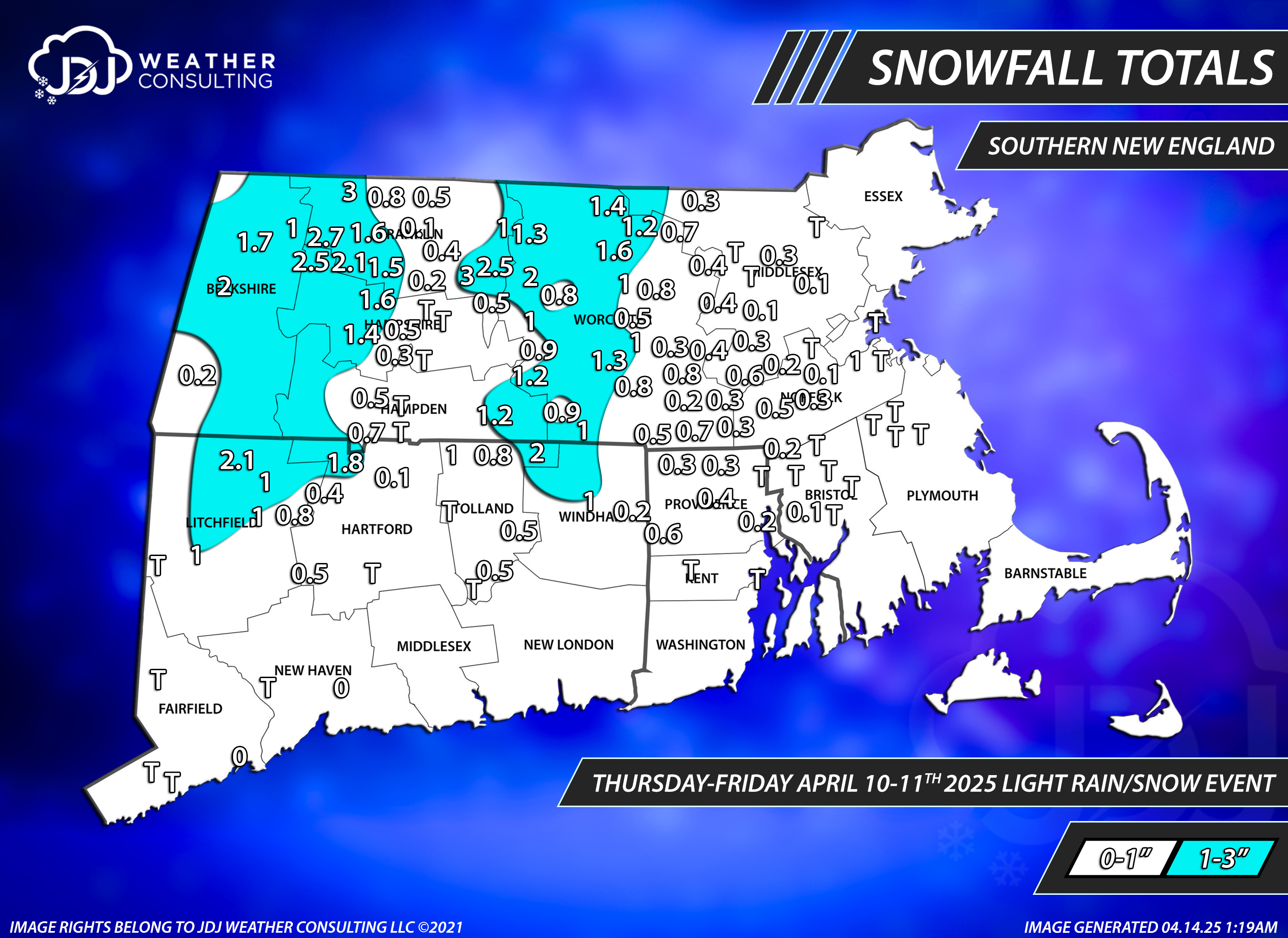
Snowfall totals for Apr 11-12
-
Snowfall Totals for Apr 10-11th and Apr 11-12th


-
Rain 36. Should be ripping in Litchfield cty especially if it's been sticking in Enfield a couple hours ago. Went 2-5 there, don't think that'll be a problem to hit. Let me know your snowfall totals for CT. I'll be putting together maps for both events
-
2 years ago we were kicking off a 3 day heat wave with temps getting up to 96 at BDL and 90 at ORH, wild to think about.
-
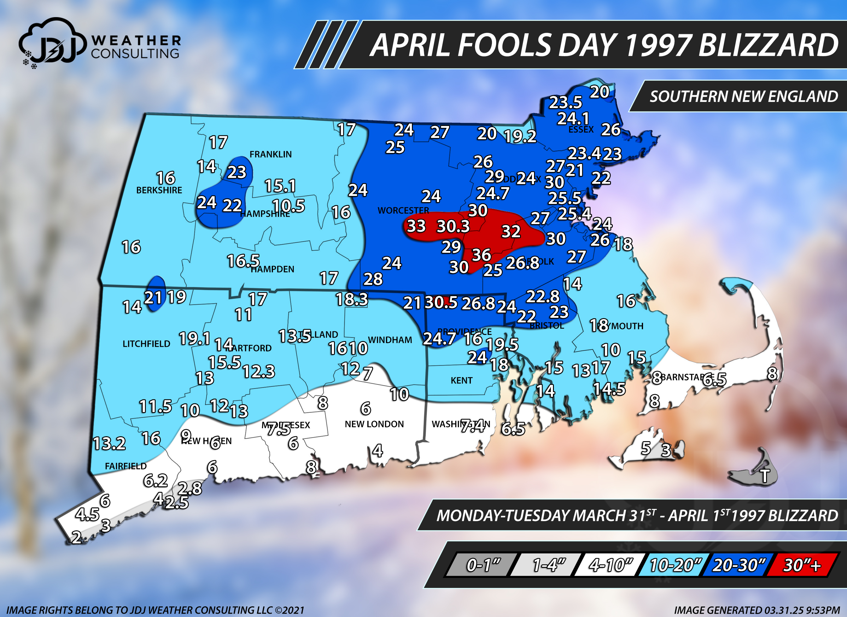
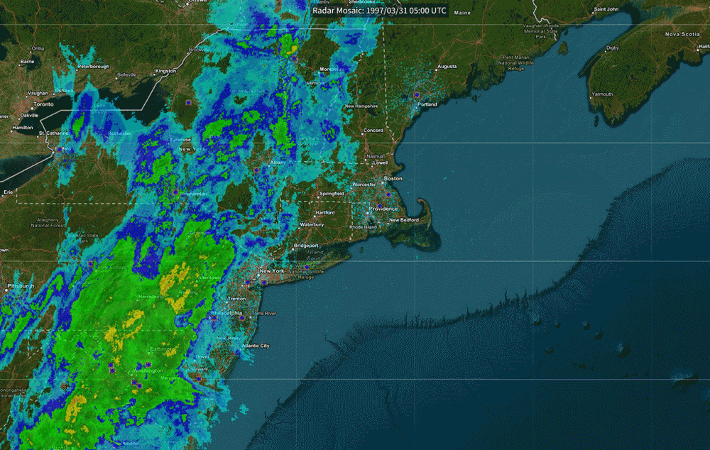
April Fools Day Blizzard
-
Today is the 28-year anniversary of the April fools day blizzard of 1997. Here's the SNE map and radar animation GIF i made for it. I couldn't find any good radar images or loops of this event, being so old, so i made my own using the NCEI radar archive. I updated our historical section with more maps and surface loops of the event. @40/70 Benchmark thought you might like this. I have the full non-compressed GIF but its like 200mb so i couldnt attach it here.


-
Winter 2024-2025 All Snowfall Totals Maps (CT/SNE)
The 4 Seasons replied to The 4 Seasons's topic in New England
****UPDATE**** NEW Ice Storm page for CT Historical Section: added 2023, 2022, 2021, 2020 snowstorms Unified color scheme for all maps and better consistency across mobile and desktop Winter 24-25, 23-24, 22-23 now has separate pages for CT/SNE/Tri-state maps only or you can view them all together in the main page -
i feel like 06-07 did as well but i think it was just a sleet fest. V-day 07 was like 3" of pure sleet at Danbury i remember. And the storms after it i think were sleet and snow. The big 08 icestorm did not affect CT really. mostly Mass to VT/NY and 08-09 i got a good one in january.
-
Winter 2024-2025 All Snowfall Totals Maps (CT/SNE)
The 4 Seasons replied to The 4 Seasons's topic in New England
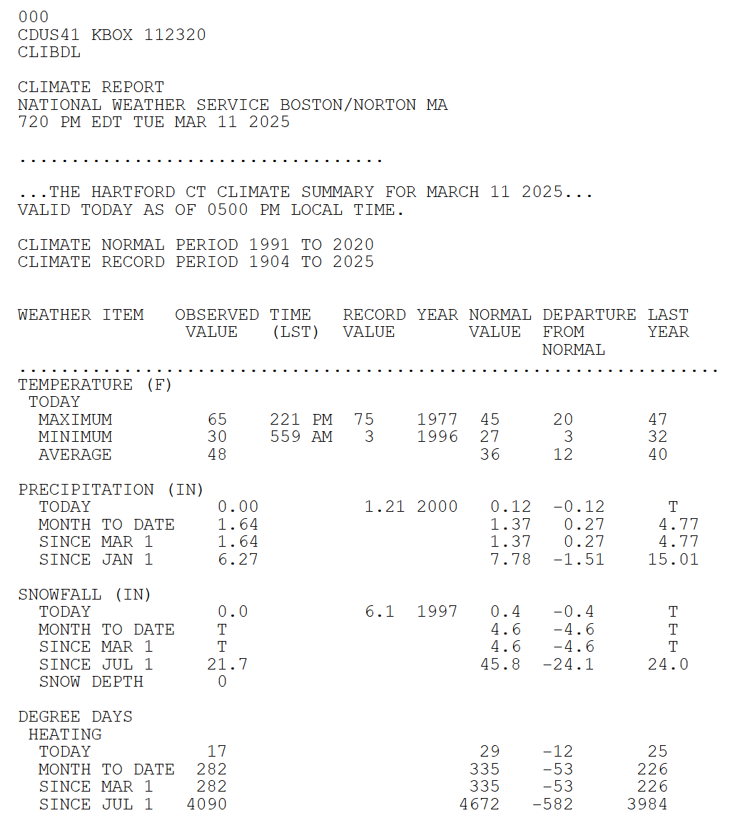
well i guess theyll update the climo page then at some point. i have a feeling it might be Feb 16 because their report was suspiciously low...slightly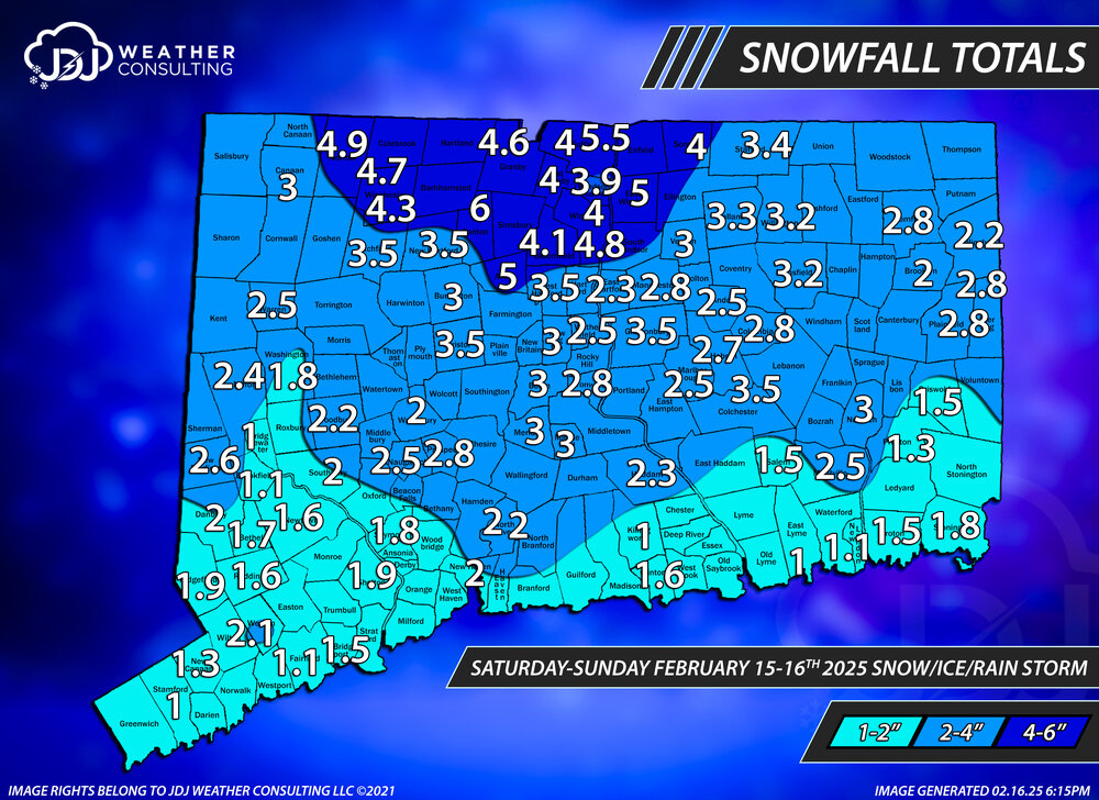
-
well any other years/events that i dont have for ice let me know if you think of anything
-
Winter 2024-2025 All Snowfall Totals Maps (CT/SNE)
The 4 Seasons replied to The 4 Seasons's topic in New England
where are you getting that number from? did they release something? The climo page still has 21.7 and the NOWdata still adds up to 21.7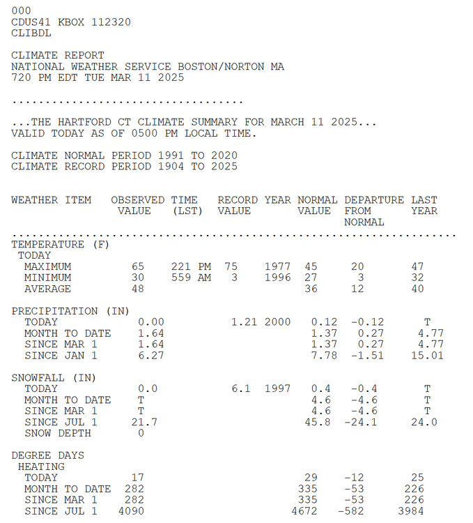
-
i think this site has every one of them available, if its not there it likely doesnt exist. https://mesonet.agron.iastate.edu/wx/afos/list.phtml?by=cccc&source=ALY&pil=AFD&year=2002&month=11&day=16&year2=2025&month2=3&day2=11&view=grid&order=asc
-
Yeah i remember sleet began Sunday night and lasted on and off through monday night, then we went to pound town. I would have loved to seen that modeled today, that was before i started even looking at models. I remember Kocin calling it "probably the biggest storm the NYC/tri-state area has seen in over 50 years" Looking back i think he was referring to current record for NYC at the time which was the blizzard of 1947. 12/26-27/47. I didn't realize that fell on the same dates as the Blizzard of 2010 until now.
-
Winter 2024-2025 All Tri-State Snowfall Totals Maps
The 4 Seasons replied to The 4 Seasons's topic in New York City Metro
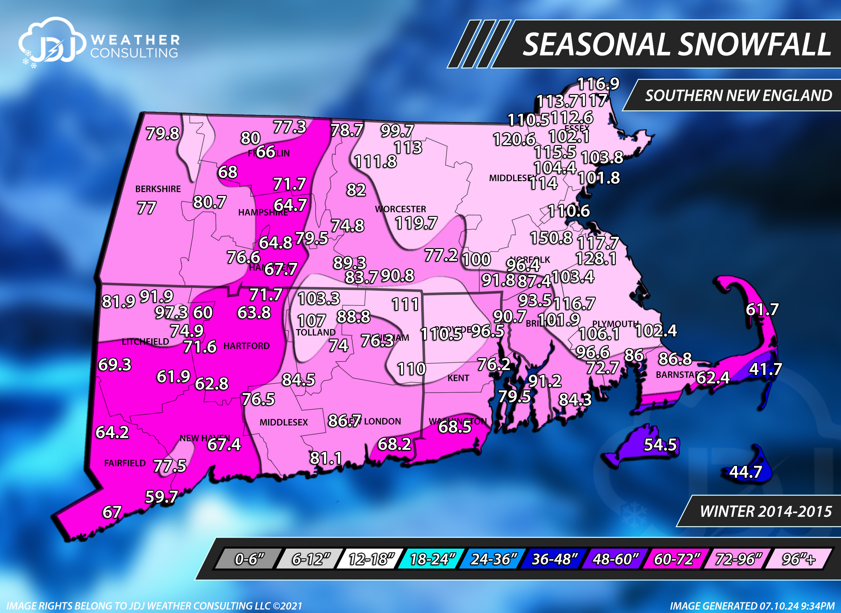
i mean its really like much closer to 10ft, which is 120" as there was probably a report or two over 120". The 150"er is Blue Hills they were in the best spot possible that season, closest to the coast and elevated.