
geddyweather
-
Posts
768 -
Joined
-
Last visited
Content Type
Profiles
Blogs
Forums
American Weather
Media Demo
Store
Gallery
Everything posted by geddyweather
-
Hello, BFE resident here. You guys can have it. No skin off my back I promise you. A 3-5" event this late in April is definitely noteworthy, even around here. And if we push 5"+? It'll be remembered for a bit. The SE trend has been amazing this year locally: one double digit big dog, several good 3-6"-ers, and now this. My bigger worry unfortunately is the cold blast that follows. Think we are setting up for a very significant freeze especially Wednesday night as skies clear and the northwesterlies die down some. Next 36 hours are going to be spent trying to protect as much plant life as possible since many things are very far along for this time of year.
-
New Tornado Warning for Choctaw County, AL. This is the lone supercell crossing into the state from MS.
-
Tuscaloosa cell just wrapped up a massive BWER. Huge couplet heading for the south and east sides of the city.
-
Coming very very close to Moundville, AL (pop: 2,427).
-
May be about to get ugly in Tuscaloosa/Birmingham metro regions, unfortunately...
-
Going to come dangerously close to Shubuta, MS (pop ~400).
-
Possibly a new tornado forming near Quitman, MS. No warning yet but probably coming soon at this rate.
-
Multiple areas of rotation now forming around the current TOG. One area of interest near Quitman MS and another west of Laurel near Soso, MS. Cell moving into Selma, AL also looks to be pretty intense. On a very bad path too.
-
Just witnessed a CC drop right under the couplet due east of Laurel. About to cross US 84.
-
Both storms NE of Hattiesburg near Laurel,MS are really starting to rotate. Also watching the tail-end charlie cell SW of Birmingham, AL. Lots of comma shapes across area radars already very early on.
-
Alright, cut the crap fellas. It's go time. Convection starting to develop in srn MS along I-55. Would watch these cells first. Shocked to see that probability upgrade at 1630z.
-
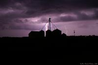
9.5” event total for here north of Lima. Total depth including previous snow pack would be 14-15”. Most snow we’ve had in years. Several drifts reaching waist-high depths.
-
Definitely ~1/4 mile vis here. Ripping hard with sustained winds around 15mph and higher gusts. Thought I had a secure measuring place but it has been well drifted over by now. Very impressive storm with much more to come.
-
Pound town here north of Lima, OH. SN with great dendrites, intensity continues to ramp up as the hours pass. Definitely starting to get windier as well. Will measure at 5pm.
-
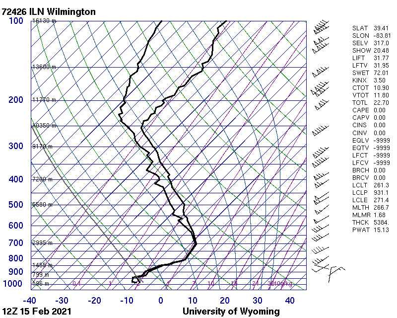
Knew there were gonna be some broken hearts in central/srn OH when I saw this sounding from ILN this morning. Warm nose strikes again...
-
Fwiw I came home from work to see the NW shift happen and have looked like the cat in the HeavyBreathing.gif ever since. That said, I am taking some of the gaudier totals on Kuchera maps with a grain of salt. As discussed at length, temperature profiles are going to be good pretty much across the board for high-ratio snowfalls, but of course there are other factors at play when it comes to SLRs. Thinking that knocking a couple inches off all across the board may not be a bad idea but we’ll see. Feel for the folks in the WFOs around here. Going to be a hectic couple of days. G
-
OT but I am absolutely thrilled to see Steely Dan in this thread no matter the context. On the subject of products/headlines, currently sitting in NW Ohio in IWX territory under a WWA. To my south are winter storm watches, to my east is nothing. It has been puzzling to see how this has been handled so far compared to past systems this season. In my honest, non expert opinion, I see no problem going with an advisory vs a watch at this juncture as both have means to be upgraded should track/amounts adjusted. However, having a gap of nothing essentially in the middle of these products is inexcusable. Makes the messaging worse and almost seems like a sign of poor collaboration between offices (which I hate to fling around, but that’s how it seems from the outside). /endrant This has been a fun one to follow. Looking forward to another 3-6”+ thump from my position. Been awhile since we’ve had a stretch of winter like this. G
-
Welp, probably should start paying attention to the ZR potential locally. Gross. Loving the eye candy though regardless. So nice to have something of substance to track and not a parade of meager shortwaves.
-
November 30-December 2 *Potential* Winter Storm
geddyweather replied to Hoosier's topic in Lakes/Ohio Valley
Which, for what its worth, was not as progressive with the southern piece. Sfc low in still in E KY at 72h compared to WV region on GFS/Euro. Heck of a thump in west central OH with that one. Find this setup very interesting, early season Apps Runners are not something I am well acquainted with. Seems like the northern stream piece has been stout and consistent enough that getting at least SOME snow here imby seems likely. However, phasing systems have not been kind as of the last couple years, so I'm hesitant to buy the hype overall. Sat/Sun are going to be very revealing especially as all the pieces get sampled. -
https://noaa.maps.arcgis.com/apps/MapSeries/index.html?appid=858309daa74f4e6ebf81f32d128f7ed8 Extremely well done interactive link by NWS Marquette, MI on the Wreck of the Edmund Fitzgerald. 45 years ago tonight...
-
Been lurking in here and man is this both equal parts fun and terrifying. If I had to throw a guess, lets go with: 898mb/165kts. Idc if this is late or not. Just doing it for posterity.
-
The "Double Trouble" Banter Thread
geddyweather replied to Windspeed's topic in Tropical Headquarters
I do not believe your eggdrop soup was hot enough to burn your tongue. Did you measure it with a thermometer? We need visual data of the thermometer or it didn't happen. No excuse for not taking data in every square inch of the soup bowl. We need better thermometers. SAD. -
The "Double Trouble" Banter Thread
geddyweather replied to Windspeed's topic in Tropical Headquarters
Eh, yes and no. Not claiming to be an expert on this either by any means (that's why I'm still in school!), but you are correct in that southern eyewalls often do look weaker than their northern segments. I don't think it is incorrect to say that Laura's does look surprisingly weak, there are other examples that look better, but I think it's important to take it as a part of the larger picture (eg: it has appeared this way for most of the day, the storm has managed to strengthen some regardless, etc). Just my 2 cents. -
The "Double Trouble" Banter Thread
geddyweather replied to Windspeed's topic in Tropical Headquarters
This is the ticket. Here's the thing, even if the southern eyewall does open up (either through ERC, shear, dry air, simultaneous bird farts, whatever), guess what: you still have a 135-145mph storm roaring onshore vs 150-155mph. With a storm this size, the differences are going to be minimal. Especially with the surge being a factor. Edit: sorta ninja'd. -
The "Double Trouble" Banter Thread
geddyweather replied to Windspeed's topic in Tropical Headquarters
That eyewall disco...is everyone..ok?

