geddyweather
-
Posts
768 -
Joined
-
Last visited
Content Type
Profiles
Blogs
Forums
American Weather
Media Demo
Store
Gallery
Everything posted by geddyweather
-
This complex is just incredible in terms of impacts. Along with your standard convective element, you've got High Wind Warnings for the trailing meso-low, and now: Lakeshore Flood Warning posted via GRR due to an increased risk of seiche/meteotsunami along the Van Buren County shoreline of Lake MI.
-
Quick mesoanalysis check: MUCAPE ballooning over 5000j/kg in IL with big time mid-level lapse rates, topping out at 8.5C/km in the area of Chicago metro. Maybe one of the best MCS environments we have been presented with all year?
-
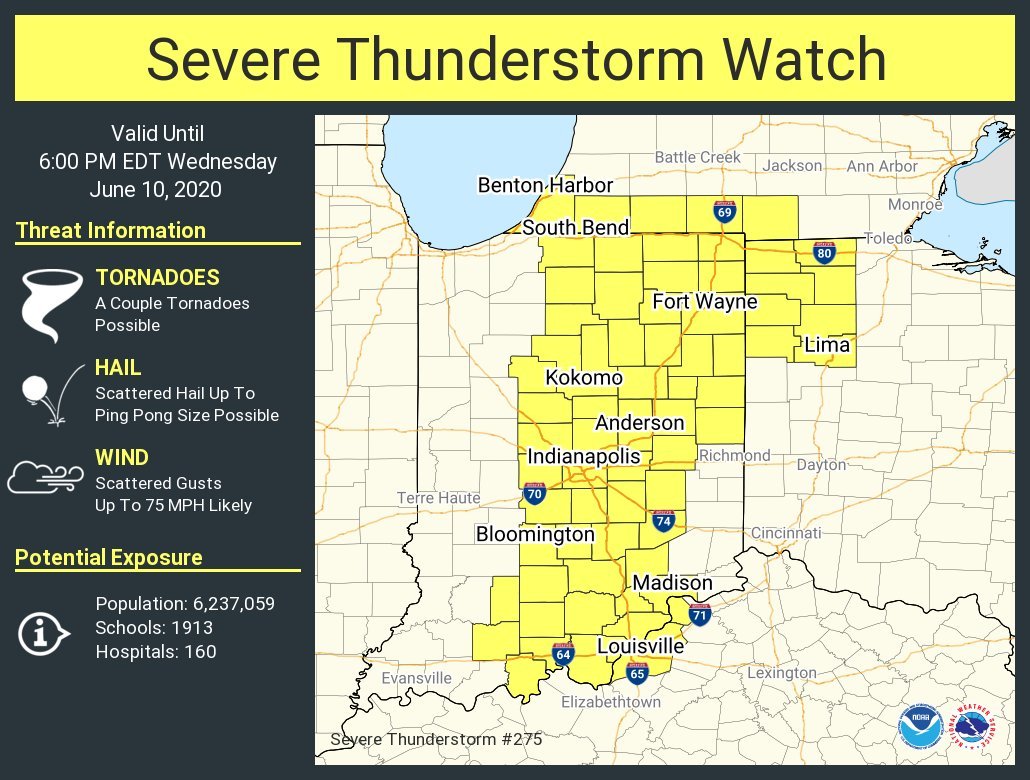
Not much change with the 1630z D1. 30% hatched wind got extended south to between Cincy and Dayton. Lots of development underway in Central Indiana.
-
-
Indeed. The HRRR seems like it has had that tendency all year, with mixed results. Wind profiles seem rather uni-directional but there is some backing near the surface, so I'm wondering if maybe a hybrid of the two (think QLCS type event) may end up being what we see? It'll be interesting, for sure. 85/76 here in Columbus Grove (north of Lima, OH), southwesterlies have been rolling all morning. SPC just hoisted an MD for IN/OH with 95% chance of a SVR watch being hoisted.
-
Surprised there isn't more chatter about tomorrow, though it "technically" isn't associated with the Cristobal remnants. Eastern IN/western OH (especially between I-69 and I-75 give or take some miles) seems like it has a decent shot at a TOR or two before things go linear. Winds aren't as backed on soundings as I'd like to see personally, but lots of other ingredients (good CAPE, lapse rates, decent low level SRH) are present. Definitely think it is worth monitoring.
-
Bingo...that circulation has looked promising the last few scans.
-
Tail-end Charlie might not be a bad place to be right now.
-

May 13-19 Severe/Heavy Rain threats
geddyweather replied to Tim from Springfield (IL)'s topic in Lakes/Ohio Valley
May have been able to drop a quick one near Lily Chapel possibly. That was where the couplet seemed the strongest, as well as where law enforcement reported it. Warning cancelled as the storm has gusted out. -
May 13-19 Severe/Heavy Rain threats
geddyweather replied to Tim from Springfield (IL)'s topic in Lakes/Ohio Valley
Tornado Warning just SSW of Columbus. Nice little embedded sup in a multi-cell cluster. Radar indicated atm. -
May 13-19 Severe/Heavy Rain threats
geddyweather replied to Tim from Springfield (IL)'s topic in Lakes/Ohio Valley
URGENT - IMMEDIATE BROADCAST REQUESTED Tornado Watch Number 193 NWS Storm Prediction Center Norman OK 215 PM EDT Mon May 18 2020 The NWS Storm Prediction Center has issued a * Tornado Watch for portions of Eastern Kentucky Central and Southern Ohio * Effective this Monday afternoon and evening from 215 PM until 900 PM EDT. * Primary threats include... A couple tornadoes possible Isolated damaging wind gusts to 60 mph possible SUMMARY...Bands of storms including a few semi-discrete/embedded supercells aside from more prevalent bowing segments will continue to increase and organize within a moist environment ahead of an eastward-moving cold front.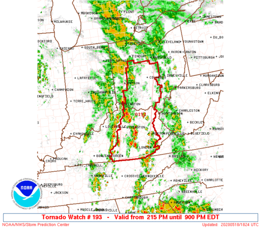
-
May 13-19 Severe/Heavy Rain threats
geddyweather replied to Tim from Springfield (IL)'s topic in Lakes/Ohio Valley
Sun is out here in western OH. Not exactly what I was thinking for today, but ok... Curious how this impacts the SVR aspects of the day. Not near the best wind profiles by any means but wonder if some extra instability could offset some things. -
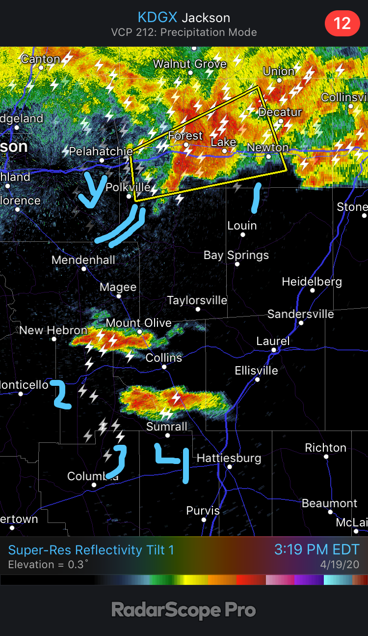
Hoping it splits the middle between Purvis and Hattiesburg. Gonna be close. There is both an industrial area and a residential subdivision there NW of Purvis on Maps.
-
The lead supercell along the WF in MS dropped what appears to be a trailing OFB, moving SE toward the free storms. Curious to see what the result of this interaction will be...

-
Places around Dayton and Springfield reported thunder with the rain/mix/snow bands today. Wouldn’t be shocked to see more convective elements imbedded in this next round, like you mentioned.
-
Apr. 6-8 Severe Risks
geddyweather replied to Tim from Springfield (IL)'s topic in Lakes/Ohio Valley
Getting "Giant Hail" on the hydrometer classification, along with 70 dBZ and a bottomed out diff. reflectivity. This is gonna be a mess with the wind no matter what the actual hail size is. -
Apr. 6-8 Severe Risks
geddyweather replied to Tim from Springfield (IL)'s topic in Lakes/Ohio Valley
That big-time hailer south of Lafayette is taking aim at the northern/eastern sides of Indy. Yikes. -
Apr. 6-8 Severe Risks
geddyweather replied to Tim from Springfield (IL)'s topic in Lakes/Ohio Valley
SPC thinking Srn MI has the best chance for discrete activity, and I tend to agree with them. Thinking the unidirectional wind profile plus rapid upscale development pushes this linear earlier than expected. -
Apr. 6-8 Severe Risks
geddyweather replied to Tim from Springfield (IL)'s topic in Lakes/Ohio Valley
71/63 and Mostly Sunny imby, wind SSW at 12mph. Can I just say how AMAZING it is to have a clean warm sector for once? -
Apr. 6-8 Severe Risks
geddyweather replied to Tim from Springfield (IL)'s topic in Lakes/Ohio Valley
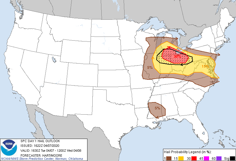
Aaaand there she is. 30% hatched for hail. Also leaves the 5% TOR along the OH/MI/IN border. Can't remember the last time we had such a widespread hail setup recently.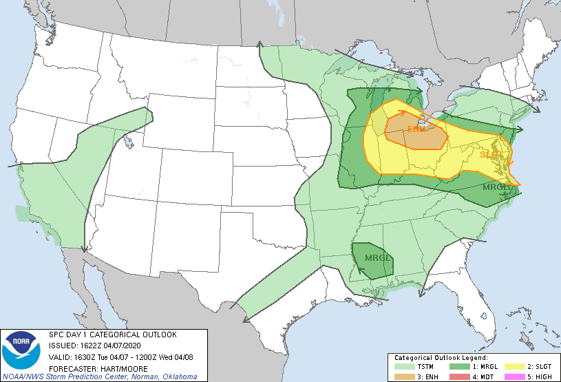
-
Apr. 6-8 Severe Risks
geddyweather replied to Tim from Springfield (IL)'s topic in Lakes/Ohio Valley
Definitely could be one of those "sleeper days" for sure. I don't feel like the hodos exactly scream TOR potential, but think if any development can stay relatively discrete, there's a decent shot at seeing something drop. More headline-worthy to me is the hail threat. RAP has a widespread SHIP of 2 for most of the region by 21z. Not gonna lie, I thought the lapse rates were maybe a bit overdone a bit earlier in the week, but seeing many meso models with 8.0-8.5 on the day of is nuts. Throw in a WBZ at what appears to be around 8000-8500ft and the vertical wind shear and I would not be surprised if we see several big stones around the area today. -
I forgot to even touch on that lol. But definitely need *something* out that way. I was prepared to see some expansion of the risk area, but what they did was not what I (or really anyone apparently) had in mind.
-
That D2 outlook is one of the goofier updates I've seen lately. Went from localized in the OH Valley to almost 5 whole states completely covered in SLGT including basically all of the lower/mid Appalachians...
-
March 26-28 Severe Threat
geddyweather replied to Tim from Springfield (IL)'s topic in Lakes/Ohio Valley
Next 2-3 hours are possibly gonna be the make or break stretch. Radar clearing quickly from Champaign, IL to St. Louis, MO but idk if its going to be enough. Meanwhile, interesting string of cells erupting N and E of Des Moines... -
March 26-28 Severe Threat
geddyweather replied to Tim from Springfield (IL)'s topic in Lakes/Ohio Valley
"Given existing uncertainties due to ongoing precipitation/cloud cover, and anticipated/rapid changes in the environment as the warm front lifts northward and clouds thin/clear from the west, confidence remains too low to delineate a potentially concentrated area of greatest risk, which would otherwise support high risk upgrade." Yeahhhh, kinda saw that one coming. It's the right call IMO, and it actually somewhat explains the decision making behind the PDS watch a bit.