CCHurricane
-
Posts
400 -
Joined
-
Last visited
Content Type
Profiles
Blogs
Forums
American Weather
Media Demo
Store
Gallery
Everything posted by CCHurricane
-
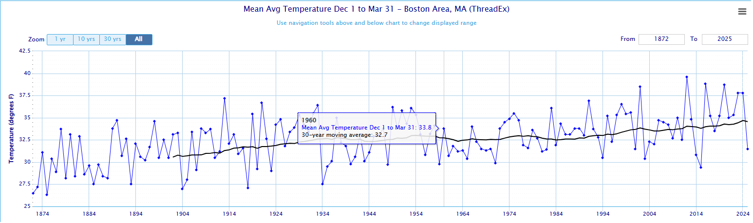
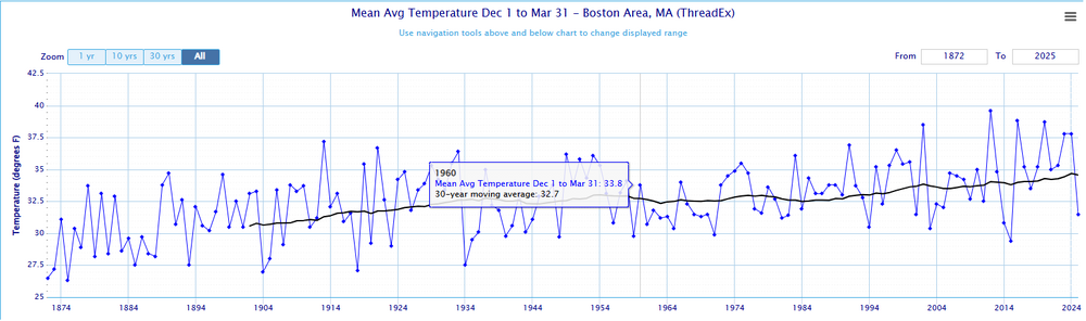
Black line is the 30-year rolling average; for BOS the 1930-1960 period was around 32.7F. Current "climate" is about +2F greater at 34.6F. Most notable is that pre-2002 and over the course of +125 years, BOS did not once see a Dec-Mar winter where avg. temps were +37.5F. Since 2002 we've seen 6 years +37.5... https://xmacis.rcc-acis.org/
-
12z NAM 3k just won't quit Cape Cod. A true scraper that feeds moisture and delivers a plowable event (3-6 inches) for most east of the Canal.
-
12z Euro has already backed off that solution unfortunately...
-
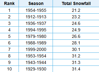
@RUNNAWAYICEBERG @HoarfrostHubb @40/70 Benchmark @ORH_wxman Lowest 10-Years of Snowfall for Worcester Area
-

December 2024 - Best look to an early December pattern in many a year!
CCHurricane replied to FXWX's topic in New England
Looks like this started on the earlier side. Will be interested to see how these bands move across and set up here on the Cape. Wellfleet and Yarmouth looks to be in a good spot at the moment. -
12/20-21 Clipper/Coastal Nowcast and Obs
CCHurricane replied to Boston Bulldog's topic in New England
Tapped out between 2-2.5” here in Barnstable. Once we lost the heavy echos of the main precip field, the accumulating snow went with it. All things considered, an enjoyable event with an interesting snowfall distribution from Boston to Cape Cod. -
12/20-21 Clipper/Coastal Nowcast and Obs
CCHurricane replied to Boston Bulldog's topic in New England
Just crossed 2” here in Hyannis / Centerville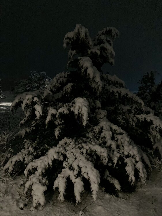
-
12/20-21 Clipper/Coastal Nowcast and Obs
CCHurricane replied to Boston Bulldog's topic in New England
Has been snowing here on Cape Cod since 5PM, best flakes of the evening so far.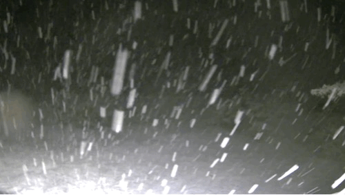
-
12/20-21 Clipper/Coastal Nowcast and Obs
CCHurricane replied to Boston Bulldog's topic in New England
Can confirm. Just drove downtown BOS to split. Temp 31 -> 34, decent snow to rain. -
12/20-21 Clipper/Coastal Nowcast and Obs
CCHurricane replied to Boston Bulldog's topic in New England
Last night’s 00Z NAM from the top rope! A winter of positive busts, could you imagine? -
December 2024 - Best look to an early December pattern in many a year!
CCHurricane replied to FXWX's topic in New England
Thanks, checked but didn't see that on the forum page. -
December 2024 - Best look to an early December pattern in many a year!
CCHurricane replied to FXWX's topic in New England
Some nice snowfall here in Boston down to Weymouth. Is everyone just completely discounting the 12z NAM and this afternoon/evening threat?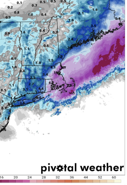
-
December 2024 - Best look to an early December pattern in many a year!
CCHurricane replied to FXWX's topic in New England
Would be quite the shift just 18 hours out. -
December 2024 - Best look to an early December pattern in many a year!
CCHurricane replied to FXWX's topic in New England
00z NAM turning back the clock a few days to show a nice moderate event tomorrow evening, with a Cape Cod jackpot if it can stay cold enough. Likely cut these numbers by 25-50%…but would be a beautiful and COLD weekend.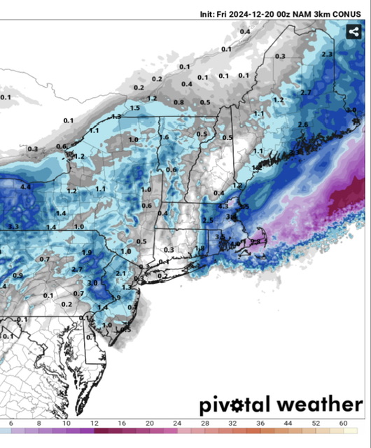
-
December 2024 - Best look to an early December pattern in many a year!
CCHurricane replied to FXWX's topic in New England
Here in Boston we are currently tracking for our "coldest" December since 2017. Zoom out a bit further however, and it just goes to show how the broader shift in climate is moving the goalposts as to what is perceived as being "cold". 2000-2010: 6 of 10 years @ 35 degrees or colder 2010-2024: 2 of 14 years @ 35 degrees or colder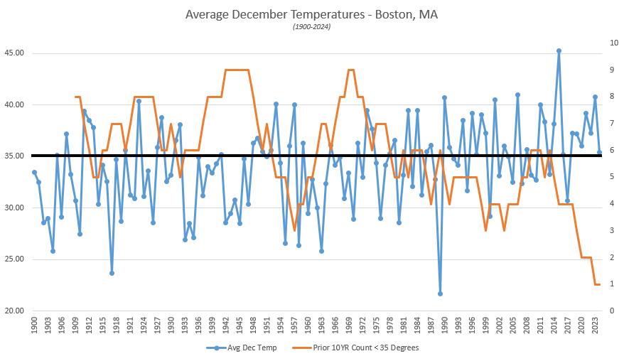
-
All things equal, 12Z EURO also showing southern FL landfall, albeit in a much better location and with a weaker system. Southern FL is mostly Wildlife Area vs. property development further North, yet this thing will be ripping from west to east in terms of forward momentum.
-
12z GFS not backing down. Landfall as CAT 3 just south of Fort Meyers, with it traversing the Florida peninsula in less than 6 hours.
-
00z GFS coming in with a beast...splitting the uprights between Western Cuba and Cancun.
-
awesome stuff, thanks for the confirm! Hopefully a sign of winter to come...
-
Mount Mansfield Snow Stake reporting 12 inches of snow? That can't be correct...is it? Would be an a record high for this early in the year, dating back to 1954.
-
Looks like a few +100mph gusts may have caused issues.
-
St Pete new high gust to 91mph @ 10:15PM. Did we lose the Sarasota Airport station? Looks like updates have ceased. https://www.weather.gov/wrh/timeseries?site=KSRQ&hours=72
-
Believe there’s some nuance to this data based on this gauge location. Looks to be exposed to a north wind. The three other Tampa Bay gauges all are running many feet BELOW normal, as the ocean has evacuated towards Tampa Bay’s mouth.
-
Goalposts narrowing between Treasure Island & Longboat Key. Regardless of Milton's exact landfall location, impacts will be devastating, yet on a relative basis a St. Pete Beach landfall would be close to a worst case scenario...
-
00z Hurricane Models at or just prior to landfall. Not nearly as much weakening as was previously modeled. HAFS-A/B take an E/ENE track from these points of reference. HWRF and HMON continue to put St. Pete (and the mouth of the Tampa Bay waterway) in the bullseye.