TSG
-
Posts
673 -
Joined
-
Last visited
Content Type
Profiles
Blogs
Forums
American Weather
Media Demo
Store
Gallery
Everything posted by TSG
-
I'm loving this cold. We didn't even make it to 40 down here in Charlottesville. CHO topped out at 39 around noon before the clouds rolled in and we're back down to 37 now.
-
Thanks for the clarification. By "bumpers" I meant the literal way the physics are implemented in the model, such as removing/correcting for known biases based on analysis of prior versions of a model.
-
Speaking from a high level here as I only casually understand the inner workings of NWP models, but the main reason is it's a physical model rolling forward based on it's own predictions. A small error made in the first few days could easily lead to downstream effects that blow up to "super rare scenarios" by day 10+. "A goat fart is incorrectly modeled in Mongolia and that causes the PV to drop into NY 12 days later" as an over the top example. You can design the system with "bumpers" to try to keep it in reality, but too much limitation and you remove its usefulness as a forecasting tool if it essentially only ever shows "climo".
-
Pretty sure I saw a few mangled flakes in Falls Church about 15 mins ago.
-
Stuck at ~43 with constant light/moderate rain since 10am in Charlottesville. It hasn't looked much past 7am here all day. I'm kind of enjoying it after what we had last week
-
This shit is gross
-
The dewpoint almost hit 60 in Charlottesville . It felt like late August at lunch.
-
So what? Do you just 100% believe every headline you see? You should be angry at Ji for posting a false statement with zero evidence, not me. And then be angry with yourself for putting in zero effort to verify the validity of that statement before going off on this insane tangent
-
The guy is still working there you ding dong! He's changing roles. You are literally making things up in your head to fit a certain narrative. And common sense would tell us a move like this would have been in the works well before last week
-
You make an accusation you have no evidence for, and then, because you know what you're posting is gossip level BS, you throw in a garbage "apology" as some kind of cover-your-ass move. What in the world are you smoking dude? Would you say this garbage to the face of your "onetime friend"?
-
It doesn't need to be defended. The multitude of times it's been discussed has provided plenty of evidence that it's accurate to its local environment. The issue is people not understanding what that local environment consists of and causes in terms of microclimates. All you have to do is look at the dewpoints to see the river influence. Low dews last night: IAD - 28 BWI - 30 DCA - 37
-
#chuckwasright
-
37 at CHO
-
https://abcnews.go.com/US/early-season-snow-cold-shocks-southeast/story?id=26623820 It happened 10 years ago!
-
I did Raven's Roost for the last one but there was a fair amount of light pollution visible from the valley there. Thinking I'll either go further south towards the St. Mary's WIlderness or head north to Big Meadows this time
-
Thanks for the heads up. I'll probably try driving up to Shenandoah. Tomorrow night looks clear for tracking and like it has the better odds for something visible.
-
correct. That photo of the washout is from hours before the dam failure. the highway is likely completely gone in multiple places by now. I really hope the stranded cars/trucks in that photo made it to higher ground..
-
wow. stronger winds mixing down with these spotty showers moving through. was not expecting this much wind here
-
Getting absolutely hosed in Charlottesville. Flood warning up through 7pm. Winds are notable as well, ~15G25 since this band arrived about an hr ago. very tropical out there
-
-
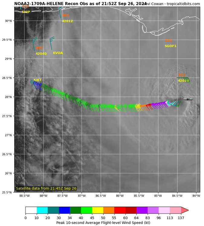
That's old. They haven't hit the western side since before the 959 pass which was at 17:57Z, or, over 3 hours ago.
-
Well I was caught off guard by the storms last night. Lost power at least once overnight in Charlottesville. Widespread reports of 3-4" across the county
-
Thats going to be tough to pull off. DCA averages ~10" of precip Oct-Dec.
-
I don't have much to add past what I posted already. Just want to say I appreciate your thoughts/perspective on things, thanks for the reply. You have any recommended reading on this topic?
-
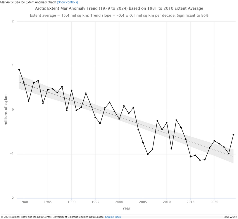
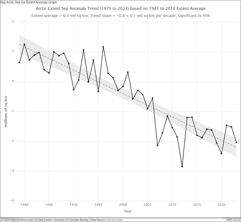
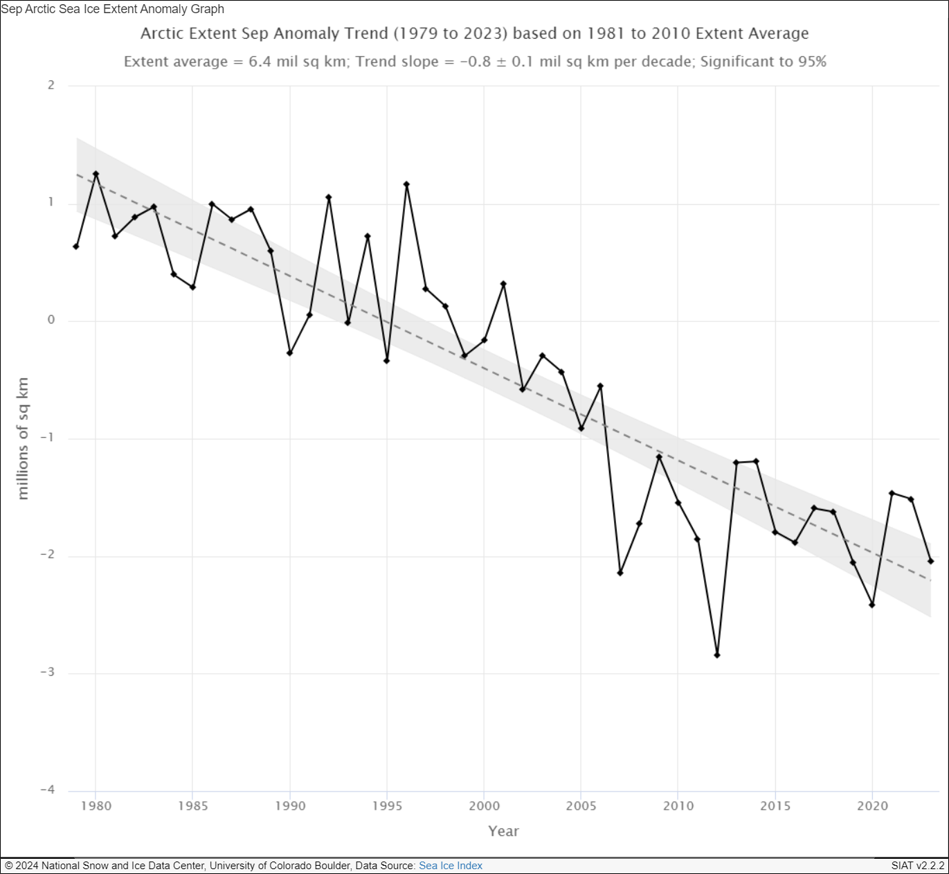
I'm very curious what effects the changes in the arctic have had on our local patterns. I've loosely tracked the seasonal ice coverage for the past ~10 years now. There's been some clear patterns but I'm not sure what to make of most of them. One of the interesting points becoming clearer the last few years is that there was a major step change in terms of summer minimum ice coverage around 2007. You can see a similar pattern in winter maximum ice extent but it's not nearly as pronounced. This largely has to do with the geography at play, the latitudes where sea ice could continue forming late winter are largely occupied by land, so there's a limit on the variation possible here compared to summer minimums. EDIT: @Stormchaserchuck1Found an interesting paper on this exact topic. https://iopscience.iop.org/article/10.1088/1748-9326/abc047 "The behavior of Arctic sea ice during recent years has perplexed the scientific community. The ice extent has attained or flirted with new record lows during winter and spring months every year since 2012, raising the specter of hitting a new minimum in September. Instead, however, the ice-loss trajectory took a sharp turn in August or early September (except in 2020), averting a broken record. Responsible for the cessation was the formation of low pressure over the region, which brings clouds, reduced insolation, and winds conducive for expanding the ice cover. The consistency of this occurrence begs the question: why is it happening? Here we offer evidence that the dramatic negative trend in spring snow cover over high-latitude land areas—one of the most conspicuous indications of anthropogenic climate change—may be an important contributor to this behavior. The early loss of snow cover creates a belt of positive temperature anomalies that distorts the typically monotonic poleward temperature gradient by creating an additional peak. Through the thermal wind relationship, a split jet is more likely to form, favoring conditions that trap and amplify Rossby waves that have been implicated in causing extreme summer weather events over northern hemisphere continents."