TSG
-
Posts
673 -
Joined
-
Last visited
Content Type
Profiles
Blogs
Forums
American Weather
Media Demo
Store
Gallery
Everything posted by TSG
-
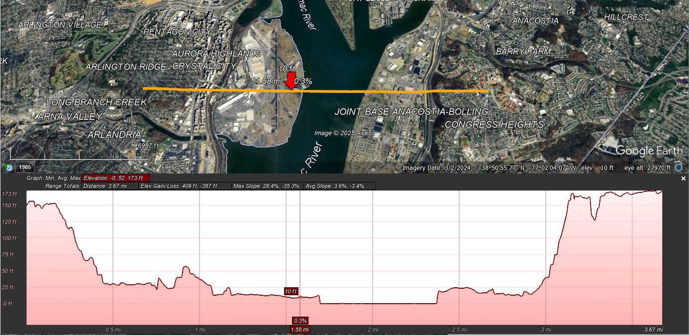
That's what I've got my eye on at this point. It could be nasty along and West of the BR. Idk exactly what storm track / system charcteristics combo we need to get this kind of setup, but it's reminding me of the mid-January storm in 2022. There was a big pocket of cold air that never really eroded in SW/Central VA. If yall don't remember that storm it was a quick front end followed by rain (for most). Down here we never really lost the surface, maybe got to 33-34 before crashing again, but areas 100+ miles north were getting blasted with 45 degree ocean air and lost anything that fell or was remaining. The end result was we had snow on the ground down here almost that entire month while the metros only had a week after the Jan 3rd storm
-
We are now entering the most dangerous territory for the snow weenie: extended HRRR and NAM at 48 hrs
-
When did I say you were wrong? Everyone here has emotions about snow chances. This is the most edge-case filled forum among the spectrum of people that care at all about the weather. How would we not? It's just that the vast majority of the people here choose to not muck up the storm discussion threads with it. It's obnoxious scrolling through the same 10-15 posts every model cycle that are nothing but "I just KNOW the north trend is coming" "It hasn't snowed 6" in Baltimore since friggin 'nam dude!" "THIS IS SO UNFAIR, WAAAAAAAAAAAH"... But that's okay! That's why the ignore list exists
-
This is the exact type of post I'm talking about
-
There will be blocking in place when the storm arrives Tuesday. The low that went North of us yesterday will become the 50/50
-
This current storm thread has added more people to my ignore list than the last 10 years combined lol CHILL YALL. We don't need to know your every waking thought
-
I don't have all the details but yes it does. Not sure how it determines melting rates, radiation effectiveness, or anything like that. Existing snowcover is a data input at simulation start
-
The big change I'm seeing is precip never really shuts off for much of the area Wednesday afternoon before the next batch makes it's way in from the "Thursday storm". The spacing there seems much tighter on the GFS compared to 24hrs ago. That'll help the CAD hang on longer and would def increase ice totals.
-
The ice threat Wednesday afternoon/evening is starting to look a little scary west of Rt15
-
I couldn't disagree more! GIMME 10" OF COLD SMOKE BABY
-
Does space weather count? The May 10th aurora was something I wasn't ever expecting to witness this far south. I only heard about it the morning of and ~12 hours later my mind was being blown parked at a mountainside lookout near Wintergreen.
-

Recent January DCA Temperatures Appear Inconsistent with 1981-2010 Normals
TSG replied to RodneyS's topic in Mid Atlantic
Gave this some more thought in the context of how our winters have been changing overall and I think I might have something. I'm focusing on the idea that our seasons seem to have shifted "to the right". i.e. Winter conditions more common in Mar/Apr, Summer conditions in Sept/Oct, etc. I don't have any kind of explanation for why, but it looks like whatever consistent atmospheric features cause these anomalies may be (a) starting later in time, (b) extending longer in duration, and (c) amplifying. The late January thaw that used to be a feature of many pre-1980s winters may be pushed out into the first week of February on average at this point. I haven't grabbed February data yet to see if this theory would actually hold water, but my memory has more than a few "early feb thaws/heatwaves" vaguely floating around. There were a couple years of cherry blossom disappointment when I lived in DC 2015-2020 from temps crashing late-Feb/early-March after said warmup and killing off most of the blooms. I could also be seeing things that aren't there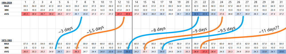
-
Recent January DCA Temperatures Appear Inconsistent with 1981-2010 Normals
TSG replied to RodneyS's topic in Mid Atlantic
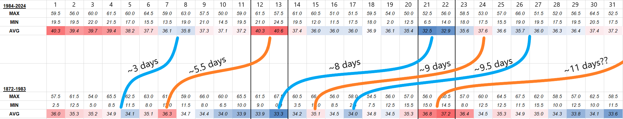
Could you do a 12/13 composite and a 21/22 composite? That may show an even stronger signal based on what I'm seeing. -
Recent January DCA Temperatures Appear Inconsistent with 1981-2010 Normals
TSG replied to RodneyS's topic in Mid Atlantic
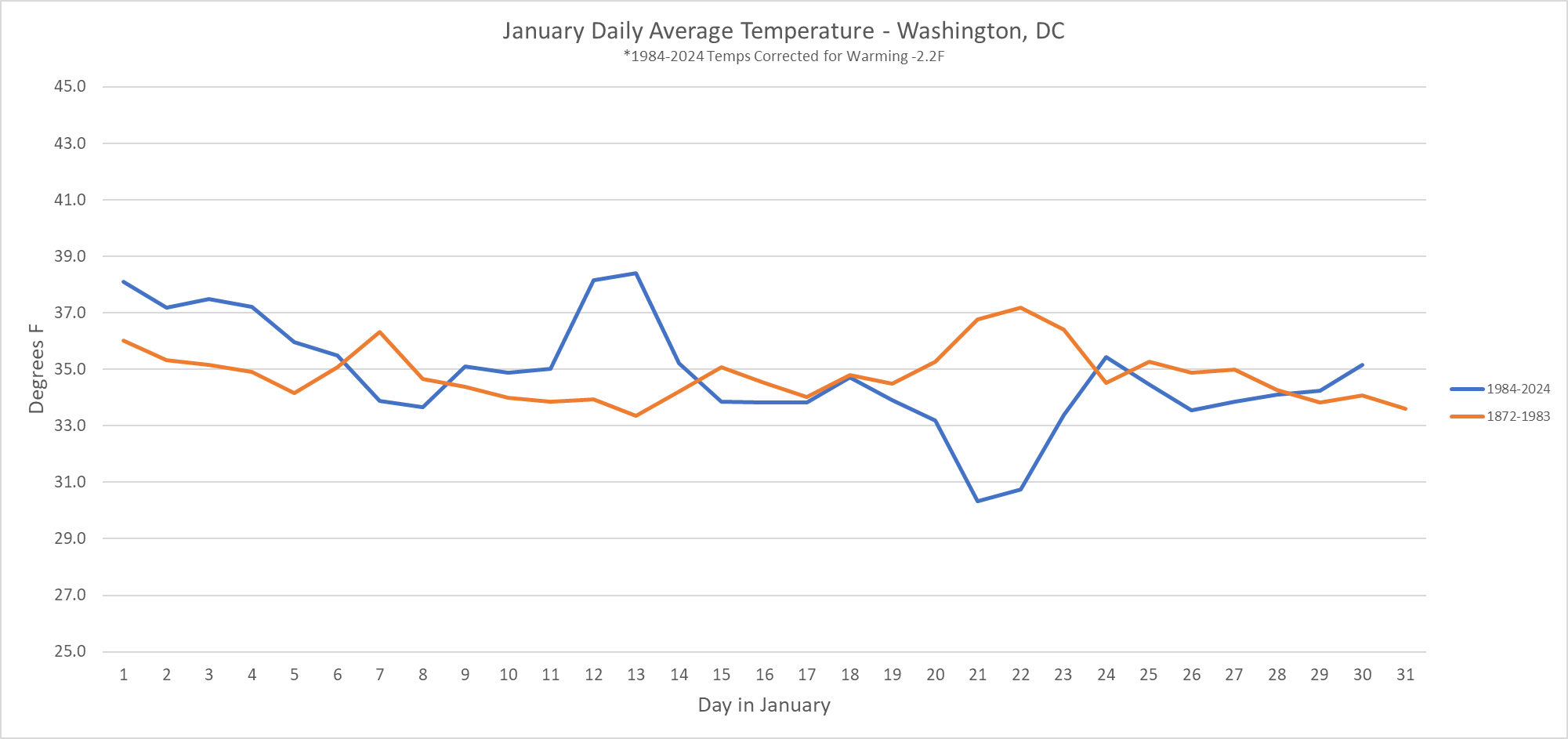
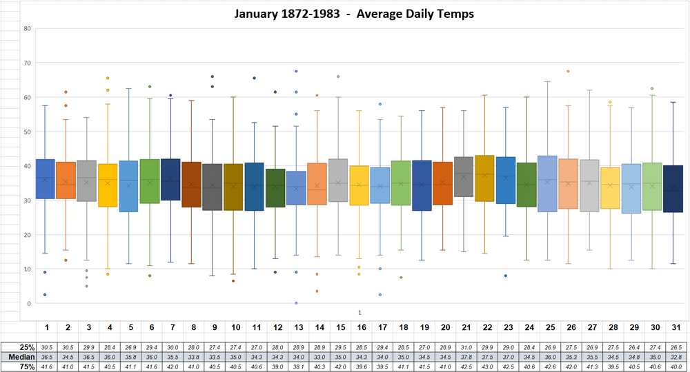
This one is kind of a recreation of Roger's from a couple years back but with the more recent data corrected for warming to make comparison easier. I took a flat -2.2F off the 84-24 values. Below is the same data but presented as the delta between the two data sets.

-
Recent January DCA Temperatures Appear Inconsistent with 1981-2010 Normals
TSG replied to RodneyS's topic in Mid Atlantic
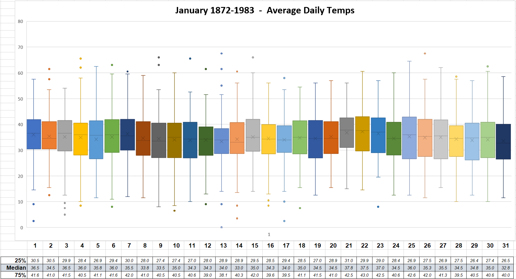
@RodneyS Was curious if this view would reveal anything within the DC data. Only thing I've picked up so far is that this phenomenon seems to be visible on the 12th and 22nd as well, and that Jan 4th has been all over the place the last 40 years lol. Have you thought about including those two dates in your analysis?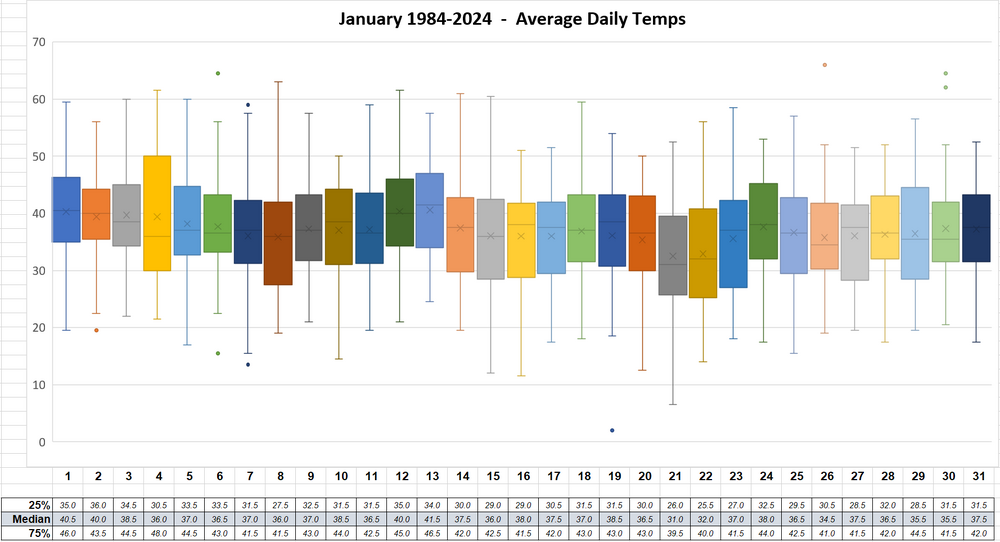
-
Oh I know haha. I genuinely enjoy analysis like this. I do stuff like this fairly often for work to assess potential micro-climate effects on solar plant production. I might just turn this into a mini thesis level copypasta EDIT: I also spent 10 years working summers at the marina just south of the airport on Daingerfield Island. I know that terrain like the back of my hand. The river valley around the Potomac contributes to higher temps in the summer as well. it would often be 5ish degrees warmer at work than where I lived near FC/Annandale.
-
Also not quite sure how you expect the ~300ft of trees that are stuck between a small city and over 400 acres of paved parking lot and tarmac to be the primary driver of temperature there lol You do realize there are 100000000x more trees around IAD and BWI, right?
-
Oh ok. If there's so many stations that support your assessment how about you actually put that analysis together for us. It must be an easy job if there's so much supporting data around.
-
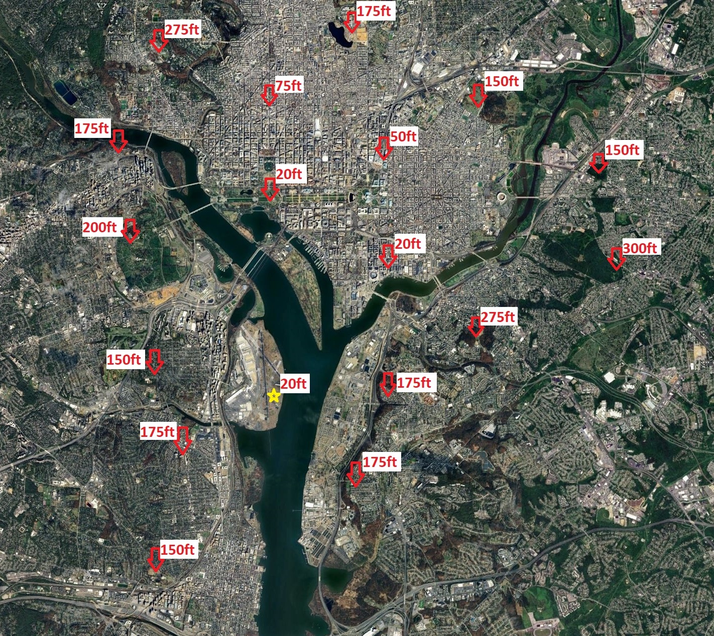
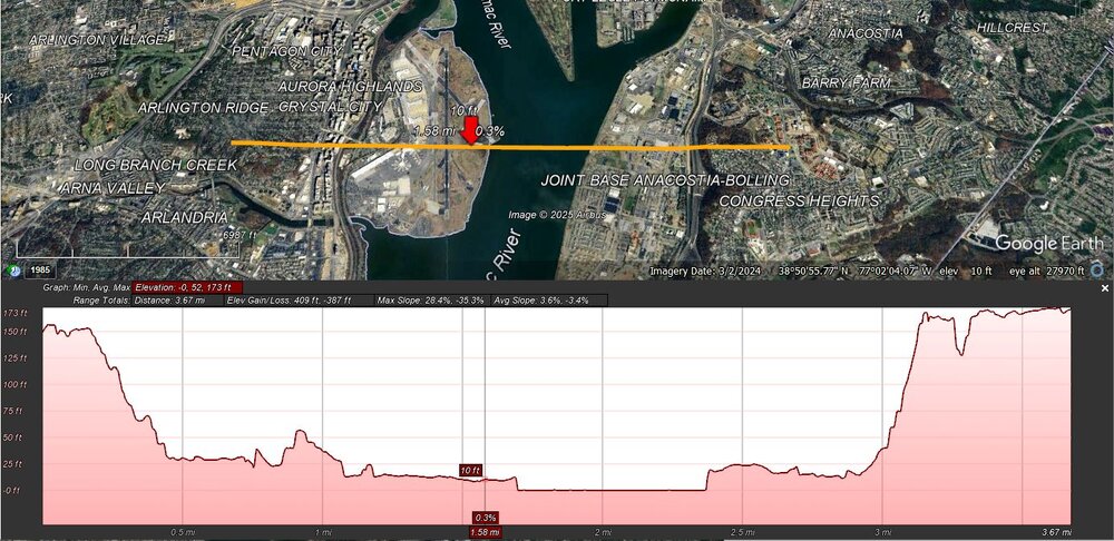
Nope. There's no defect, it's a combination of factors and this has been explained many times. Here it is again: Early in the season the Potomac is contributing significant warmth. This is obviously not a factor at this point as the river has frozen over. DCA radiates horribly due to being in a relative "bowl" within its landscape. See the images below. BWI is on a high point within its environment, basically the exact opposite of DCA, and IAD is in an open plain. Neither location has a significant portion of its upward view obstructed by urban environments. Portions of the sky or treelines at ambient temp that are visible at the BWI and Dulles measurement locations are replaced with city skyline radiating heat back towards the airport. This environment also contributes to localized downsloping effects. IAD is at ~325ft above sea level. Where I grew up in Falls Church it was basically the exact same elevation with a few hilltops closer to 400ft nearby. That's 17 miles as the crow flies with basically zero elevation change. You then lose those 300-400ft in the next ~6 miles which will net over a degree F in temperature increase. You also get an enhanced UHI effect when wind is coming in from the West/Northwest, which it often is when this "issue" comes up. That entire strip west of the GW parkway is ~250-300ft tall buildings built primarily in the 70s and 80s that have next to no insulation and constantly belch wasted heat into the environment during the winter. It's a one mile long, quarter mile wide heat exchanger that's less than a mile away from the measurement site. Nothing like that exists for either of the other locations. Although I could imagine IAD may be seeing similar effects on a North wind from the massive amount of data centers that have gone up the last 10 years, but they are much further from the sensor location. The overall UHI effect across a metro region is not anywhere close to homogenized or a standard gradient extending out from the cities. It's highly dependent on the local environment. Show up with some actual data if you legitimately think this needs to be looked at. Otherwise you're probably going to get this response from me every time you bring it up.

-
It wouldn't have felt like a real arctic outbreak without my heat going out one night
-
Recent January DCA Temperatures Appear Inconsistent with 1981-2010 Normals
TSG replied to RodneyS's topic in Mid Atlantic
Fascinating for sure and fun to follow along all these years. I was still in college when this first got posted and it really caught my attention as it was maybe the strangest weather related phenomenon I had ever come across/read about at that age. I hadn't even made an account on here yet, I was just a perennial lurker in the winter months. Keep it up Rodney! -
Cold smoke
-
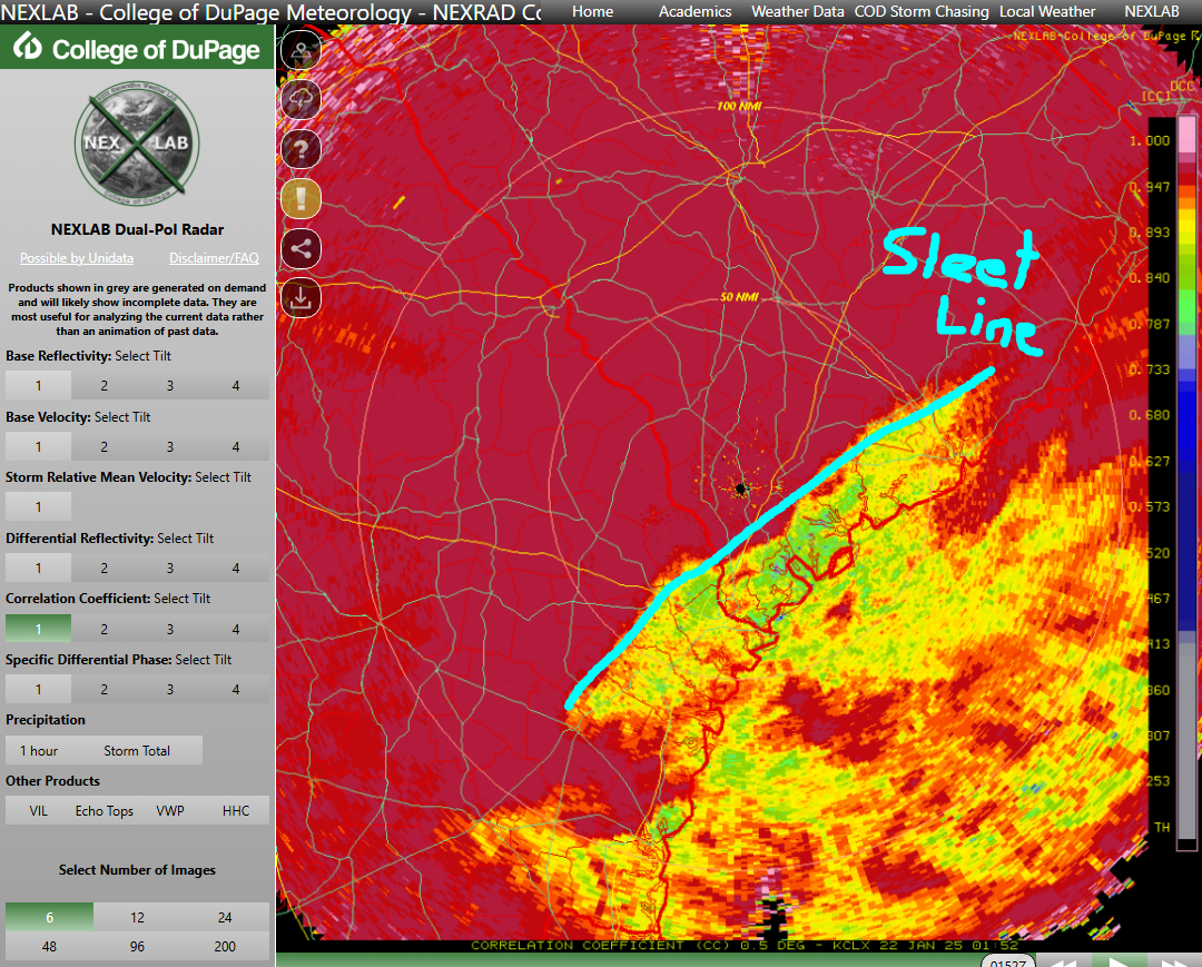
Hope I'm not explaining something well understood here... thinking this might not be common knowledge in the SE. You can see sleet vs snow pretty well using the correlation coefficient or diff reflectivity products. Rough sleet line outlines below for SC/GA

-
Any CHS posters in here? Looks like yall are getting sleet-bombed right now based on radar