paulythegun
-
Posts
808 -
Joined
-
Last visited
Content Type
Profiles
Blogs
Forums
American Weather
Media Demo
Store
Gallery
Everything posted by paulythegun
-
YES. radar hallucinations have started!
-

Jan Medium/Long Range Disco: Winter is coming
paulythegun replied to stormtracker's topic in Mid Atlantic
For those who didn't get what "convection over the MC" is (me until 60 seconds ago) here's a neat little study where i figured it out: https://agupubs.onlinelibrary.wiley.com/doi/full/10.1029/2022MS003503 Summary: Large-scale convection associated with the Madden-Julian Oscillation (MJO) initiates over the Indian Ocean and propagates eastward across the Maritime Continent (MC). Over the MC, MJO events are generally weakened due to complex interactions between the large-scale MJO and the MC landmass. -
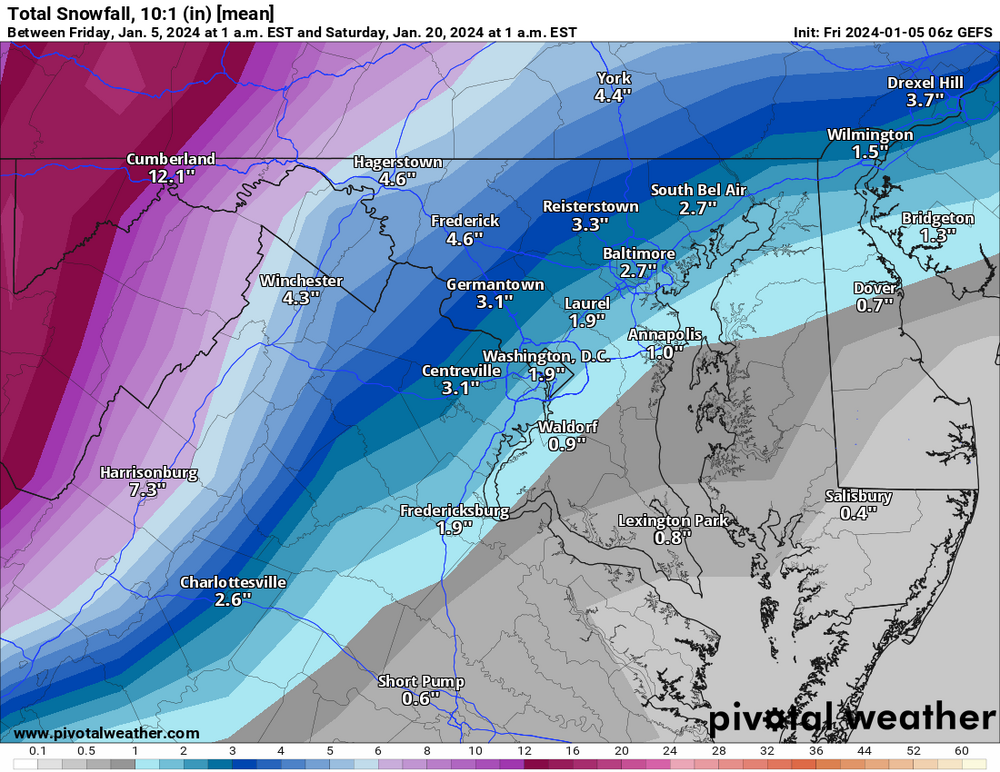
10 to 1! and half of this is from "tomorrow" (!!!)
-
Really stinks for Virginia ski resorts if they can't get a nice clean snow to drizzle event. Seems reasonable. Not your focus, but the euro (and to a lesser extent, GFS) had some interaction with that trailing low that provided some hope for NYC/Boston.
-
-
ok this is just funny now.
.thumb.png.ad7d6055012f6e73c5f780e213d006fb.png)
-
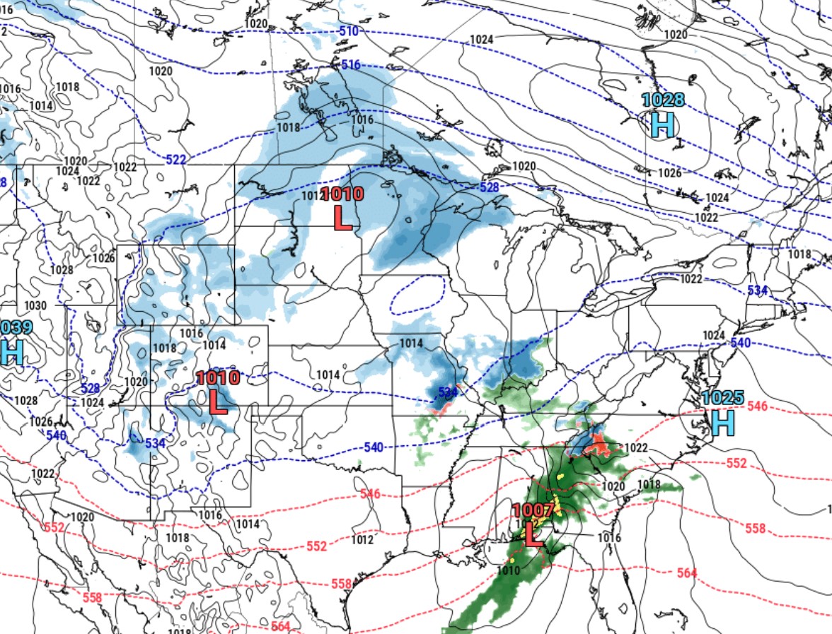
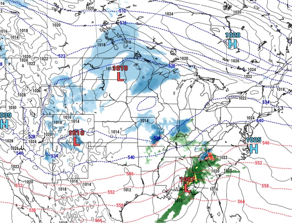
CLASSIC surface level setup for an HECS on NAM. Got your three low pressure systems (triangle defense) chasing two weak highs off the continent
-
you beat me to this. whenever someone complains about a long range map, gotta up the ante with some CFS
-
Model trend momentum is accelerating toward some extreme snowmap colors Models were accelerating in another direction earlier today. But - as we all learned in meteorology class - model trend momentum is moving toward snow now.
-
So because I’m a hobbyist, my friends sometimes ask me about the outlook for snow, as they did tonight. I rely on the long range threads here to some extent to get a feel. Plus common sense, reading trusted voices on twitter, and my own access to ensembles. Tonight, when posed with the question about our snow chances, I told a story. I told them about how there’s this weather forum where people discuss the long range forecasts for signs of potential snowstorms. And i told them that for the last few years, they had to create a separate thread called “The Panic Room” where people who loved snow could go to have a meltdown without disrupting the discussion. They got a kick out of that.
-
Jan Medium/Long Range Disco: Winter is coming
paulythegun replied to stormtracker's topic in Mid Atlantic
Anybody know the history of this kind of west meandering cut-off low in late December? Feels extremely rare, but I don’t really know. I suppose we’ve had tons of big low pressure systems delivering warm temps in dc and blizzards in the Midwest around Christmas time. Remember Santabomb? But I can’t remember a cutoff low that drifted. -
PANIC https://x.com/hotwxexpert/status/1740134509008281952
-
Days 15-20 looking like the best window for a pattern change that leads to snow.
-
Don’t worry folks. An SSW is on the way (maybe?) to disrupt the PV (maybe?), provoking sustained, upper latitude blocking (maybe?) in a location that leads to an arctic outbreak in North America (maybe?)
-
-
Thanks, I was wondering about that. 1996 keeps popping as #1.
-
90th percentile snow analog for funsies
-
A SSW will produce a cold air outbreak somewhere in the northern hemisphere. That’s our best shot for a late February pattern change that leads to anomalously cold coastal rain storms in March
-
We’re definitely not there yet (to the point of hopelessness) you’re totally right. We have recent data to confirm that. Tons of snow the last couple decades. It was always going to be a slow bleed. But at the same time: it’s objectively warmer, and that warmth is concentrated in the northern hemisphere, during winter. Bad! Haha.
-
Lava limits snow ratios. Don’t count on 10 to 1. We need the magnum rock to solidify and cool if it’s going to support accumulations.
-
warmbad2.mp4
-
Dec. 17 folks
-
If a model has 15 members out of 50 with a coastal storm with a nice track 300 hours out and 35 members with random stuff (like cutters), then the MEAN temperature is going to be worse than useless. It's going to be misleading! even if the temps were colder, it wouldn't mean much of anything because that could just relate to the timing of the cutter and associated cold front passage. think about 50 separate storms and how they average out on an ensemble map. it's like if someone said, "Well, the ensemble only has a 1000mb mean low pressure reading off the coast 300 hours out, that's not a very strong coastal storm, it's saying it's going to be a weak storm." No it's not! that's the average across a spatial domain!
-
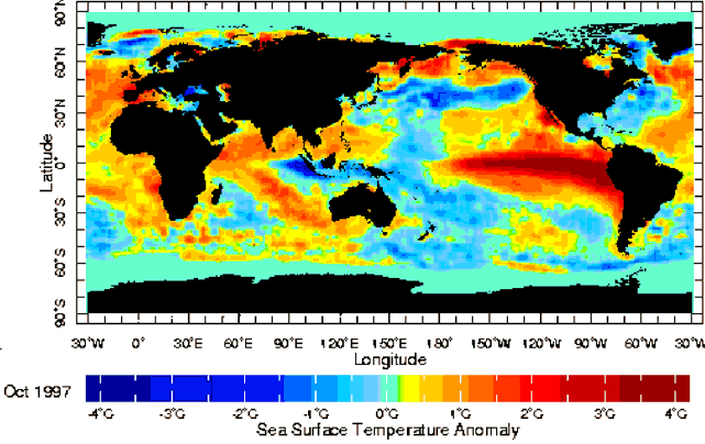
#NEverForget the victims of El Nino: sailors boiled alive in the east pacific


.png.d6a2ef979ca4da3e99b4085cc90f2536.png)