
paulythegun
-
Posts
808 -
Joined
-
Last visited
Content Type
Profiles
Blogs
Forums
American Weather
Media Demo
Store
Gallery
Everything posted by paulythegun
-

Jan/Early Feb Medium/Long Range Discussion Part 3
paulythegun replied to WinterWxLuvr's topic in Mid Atlantic
ECMWF keeps hope alive for the 5th/6th (I guess). Slower, a bit north. 00z Euro had these two features (circled) crash down and seemingly whisk whole thing out to sea. 12z euro doesn't' have them. -
Jan/Early Feb Medium/Long Range Discussion Part 3
paulythegun replied to WinterWxLuvr's topic in Mid Atlantic
Yeah I've always had this (noob) question of whether a higher resolution model could "trick itself" by aggressively identifying noise (smaller features) and failing to smooth those out. But I guess that's just a convective feedback loop? -
Jan/Early Feb Medium/Long Range Discussion Part 3
paulythegun replied to WinterWxLuvr's topic in Mid Atlantic
4 out of 20 members of CMC Ens have snow reaching here Feb. 5/6. Two have a liquid explosion. Therefore, 10% chance of a liquid explosion. That's how this works. -
Jan/Early Feb Medium/Long Range Discussion Part 3
paulythegun replied to WinterWxLuvr's topic in Mid Atlantic
The last 5 runs (here it comes! rain bomb!) -
Jan/Early Feb Medium/Long Range Discussion Part 3
paulythegun replied to WinterWxLuvr's topic in Mid Atlantic
For the 5th/6th, EPS has these three panels + 48 panels of nothing or almost nothing. -
haha the euro smashes that thing to oblivion on Feb 5th. Smashes it back into the gulf of mexico from whence it came
-
Jan/Early Feb Medium/Long Range Discussion Part 3
paulythegun replied to WinterWxLuvr's topic in Mid Atlantic
-
Jan/Early Feb Medium/Long Range Discussion Part 3
paulythegun replied to WinterWxLuvr's topic in Mid Atlantic
I wonder what the analogs are for this one -
Jan/Early Feb Medium/Long Range Discussion Part 3
paulythegun replied to WinterWxLuvr's topic in Mid Atlantic
GFS Ext. Control AO collapses into negative infinity LMAO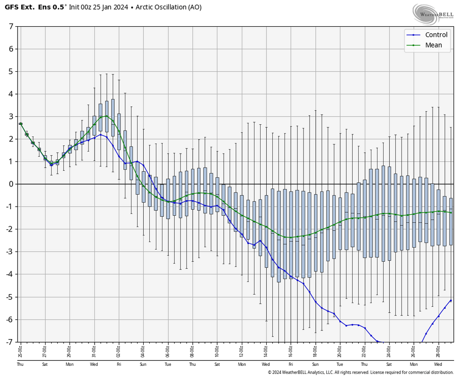
-
-
Jan/Early Feb Medium/Long Range Discussion Part 3
paulythegun replied to WinterWxLuvr's topic in Mid Atlantic
Yeah the Euro - as depicted - would probably be almost 12 hours of White Rain in the city, changing from a rain snow mix around 9pm then continuing into the morning with zero accumulation. Probably over 0.3" of QPF in and around the city with a bit more NW of the city where maybe rates overcome 34F at the surface. I'd take this as a best case! And I'd wager about 2" on my elevated (20 feet high) metal deck! -
Jan/Early Feb Medium/Long Range Discussion Part 3
paulythegun replied to WinterWxLuvr's topic in Mid Atlantic
Yep looks great! One thing i'd like to see is the good look at the end of the ensembles. They keep kicking it a day forward.....but i'll be patient! Here's yesterday's 12z EPS: VS today 12z EPS: Looking forward to seeing the blue connect with the blue!!! -
the people who complain about complaints about complainers in the complaining sub-forum are the worst!
-
Jan/Early Feb Medium/Long Range Discussion Part 3
paulythegun replied to WinterWxLuvr's topic in Mid Atlantic
As depicted on the euro, flakes would fly for many many hours (into puddles, but whatever). My metal, elevated deck will be covered though. -
Jan/Early Feb Medium/Long Range Discussion Part 3
paulythegun replied to WinterWxLuvr's topic in Mid Atlantic
This made me chuckle. take that, winter of 2023/2024 naysayers! -
Ladies and gentlemen: I give you RAIN
-
Jan/Early Feb Medium/Long Range Discussion Part 3
paulythegun replied to WinterWxLuvr's topic in Mid Atlantic
The euro is good for next monday morning if you don't know how this map works (precip is 6z-12z, 850T is 12z) -
Jan/Early Feb Medium/Long Range Discussion Part 3
paulythegun replied to WinterWxLuvr's topic in Mid Atlantic
06z Euro Control has the same look as GFS. Surface temps a disaster though. -
Jan/Early Feb Medium/Long Range Discussion Part 3
paulythegun replied to WinterWxLuvr's topic in Mid Atlantic
WE JUST GOT LULLED! -
GEFS, GEPS, EPS all have this trend at the end of the run (vs previous runs)
-
Jan/Early Feb Medium/Long Range Discussion Part 3
paulythegun replied to WinterWxLuvr's topic in Mid Atlantic
someone can correct me, but i think the problem is not just that it's warm here. it's the fear that our cold source (canada) would get scoured out as well. so you've got mild air here with anomalously warm air north of it. -
Jan/Early Feb Medium/Long Range Discussion Part 3
paulythegun replied to WinterWxLuvr's topic in Mid Atlantic
this analog for next weekend shows what might have possibly been with some cold air -
-
Jan/Early Feb Medium/Long Range Discussion Part 3
paulythegun replied to WinterWxLuvr's topic in Mid Atlantic
canada totally deflated. no pressure up there at all. -
Jan/Early Feb Medium/Long Range Discussion Part 3
paulythegun replied to WinterWxLuvr's topic in Mid Atlantic
GEFS extended (which I assume just reverts to el nino analogs after two weeks out, but that's an uninformed cynical guess) looks good in early to mid february.


