
paulythegun
-
Posts
976 -
Joined
-
Last visited
Content Type
Profiles
Blogs
Forums
American Weather
Media Demo
Store
Gallery
Everything posted by paulythegun
-

The Jan 31 Potential: Stormtracker Failure or 'Tracker Trouncing
paulythegun replied to stormtracker's topic in Mid Atlantic
I mean it's a double barrelled low with the second one like 1000 miles southeast of it, originally developing over the Bahamas. Think about it like that, and the precip shield won't bother you as much -
The Jan 31 Potential: Stormtracker Failure or 'Tracker Trouncing
paulythegun replied to stormtracker's topic in Mid Atlantic
OUTRAGEOUS. 10 to 1 snow ratios vastly undersell those totals. I demand a correction!!! -
The Jan 31 Potential: Stormtracker Failure or 'Tracker Trouncing
paulythegun replied to stormtracker's topic in Mid Atlantic
The SREF was created to deal with the failure of January 2000. Therefore, the SREF is right. The End. -
The Jan 31 Potential: Stormtracker Failure or 'Tracker Trouncing
paulythegun replied to stormtracker's topic in Mid Atlantic
SREF has between 0 and 39.56" for DCA. The mean is 11.97' and the median is 2.97". Instead of using either of those, let's go with the average of the max and min: 19.78" of snow for DCA. THANK YOU FOR YOUR ATTENTION TO THIS MATTER! -
The Jan 31 Potential: Stormtracker Failure or 'Tracker Trouncing
paulythegun replied to stormtracker's topic in Mid Atlantic
Cyclogenesis going on at the surface under those messy dashes -
The Jan 31 Potential: Stormtracker Failure or 'Tracker Trouncing
paulythegun replied to stormtracker's topic in Mid Atlantic
Need to use the Tropical Atlantic view to really understand what GFS is doing at the surface. It's offscreen on the CONUS view. -
The Jan 31 Potential: Stormtracker Failure or 'Tracker Trouncing
paulythegun replied to stormtracker's topic in Mid Atlantic
I asked Google Gemini to take a look at the 12z WeatherNext model and compare it to 06z. First, it made up a bunch of stuff. Then it made up more stuff. After insulting it literally a dozen times, I was able to get it to at least pretend to give me some data that was plausible. Here, I asked it about trends in the precip shield: The 06z Shield: Showed the edge of the precipitation (roughly 0.01"–0.05" liquid) flirting with the DC/Baltimore line. The 12z Shield: Pushed that shield about 40–60 miles further southeast. The 12z panel for 84 hours out shows DC entirely in the "dry zone" (the white space on the map), with the moisture field cut off near Fredericksburg and the Chesapeake Bay. -
The Jan 31 Potential: Stormtracker Failure or 'Tracker Trouncing
paulythegun replied to stormtracker's topic in Mid Atlantic
WOW. After ingesting MASSIVE changes in the atmosphere between 12z and 15z, SREF shows this much snow through hour 87, with more on the way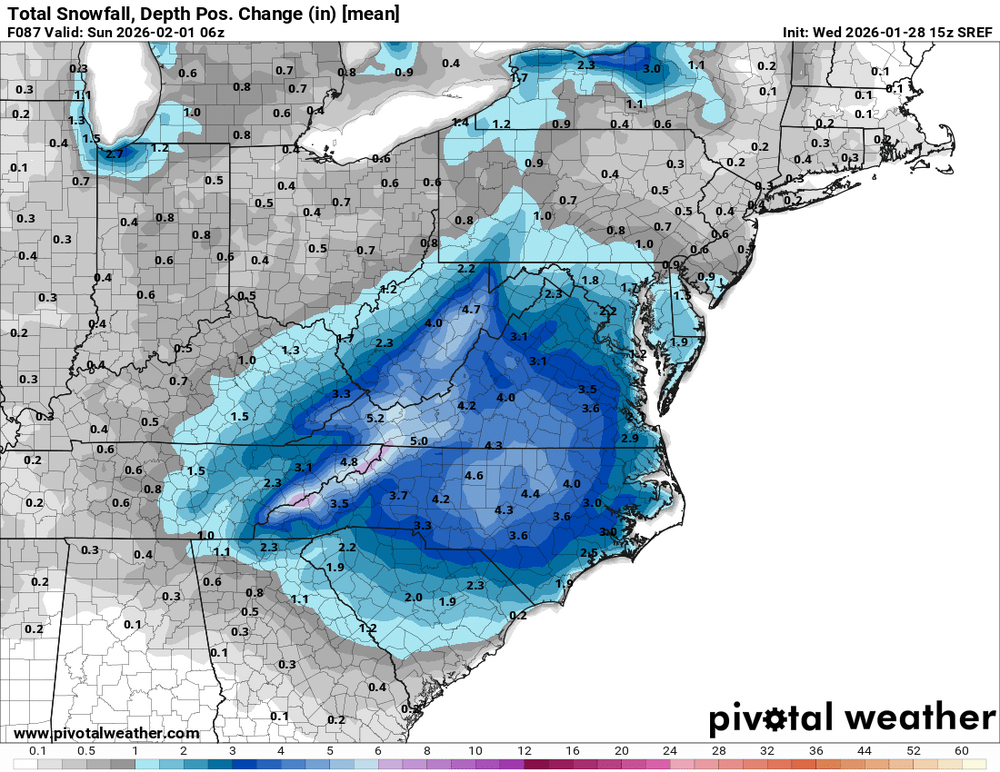
-
The Jan 31 Potential: Stormtracker Failure or 'Tracker Trouncing
paulythegun replied to stormtracker's topic in Mid Atlantic
The WeatherNext 2 trend over the last 4 runs through 06z is NW, NW, NW. Found this in another forum, cleaned it up.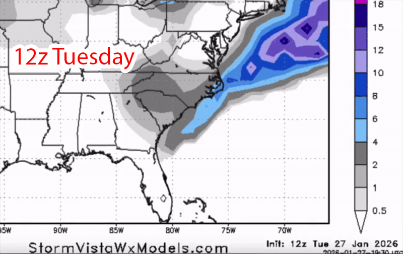
-
The Jan 31 Potential: Stormtracker Failure or 'Tracker Trouncing
paulythegun replied to stormtracker's topic in Mid Atlantic
Ukmet has been the extreme northeastern outlier on this one. It's just trying to get home... -
The Jan 31 Potential: Stormtracker Failure or 'Tracker Trouncing
paulythegun replied to stormtracker's topic in Mid Atlantic
Agreed. Spite is good. Human beings can live off of a diet of spite and water for over 90 days -
The Jan 31 Potential: Stormtracker Failure or 'Tracker Trouncing
paulythegun replied to stormtracker's topic in Mid Atlantic
I'm guessing we didn't give the Canadians our recon plane data. They never ingested it. Whereas, in contrast, GFS' belly is full -
The Jan 31 Potential: Stormtracker Failure or 'Tracker Trouncing
paulythegun replied to stormtracker's topic in Mid Atlantic
0z models Ingesting the recon plane data like this https://www.reddit.com/r/familyguy/s/mcl2GwxKro -
When it comes to this coastal low, the question facing us is this: Tuck? Or no tuck?
-
January 24-26: Miracle or Mirage JV/Banter Thread!
paulythegun replied to SnowenOutThere's topic in Mid Atlantic
You just inspired me. Prepping some steaks and shrimp -
Trust me, I'm kind of weirded out!
-
Roads not fully caving yet in DC. Some sort of new mutant salt
-
Seeing snow in DC, near the foothills of the mighty Mt. Hamilton
-
I wasnt expecting anything more than flurries before midnight. I'll wait until then to throw a tantrum...(Not here...in some group chats!) The column is saturating - fairly quickly based on the dew points. All good!
-
Trying to be positive. Trying SO HARD haha.
-
Yep! Not a big deal. Will fill in
-
Mrs. PacMan, as expected. Everything is on schedule. Waiting until about midnight for this to fill in
-
Jan 24-26 Weekend Snow and Sleetfest Model Thread Part Tres
paulythegun replied to H2O's topic in Mid Atlantic
My guess...they have like 6+ other hires models to look at that are better than NAM, if you include all the experimental ones. -
January 24-26: Miracle or Mirage JV/Banter Thread!
paulythegun replied to SnowenOutThere's topic in Mid Atlantic
-
January 24-26: Miracle or Mirage JV/Banter Thread!
paulythegun replied to SnowenOutThere's topic in Mid Atlantic
Capital Weather Gang just did the exact opposite. https://bsky.app/profile/capitalweather.bsky.social/post/3md4fnulpvc24


