RIC Airport
-
Posts
2,586 -
Joined
-
Last visited
Content Type
Profiles
Blogs
Forums
American Weather
Media Demo
Store
Gallery
Everything posted by RIC Airport
-
I'm more interested in the LR. Euro has a storm next weekend and the GFS has one the week of MLK Day. At least the 12z suite. Still looks colder and active for a time.
-
1-3" is a good call. Can't complain about getting two measurable events in the same week.
-
Best METAR out of RIC in a long time. KRIC 031854Z 33018G26KT 1/8SM R34/2400V3500FT +SN FZFG OVC007 M01/M01 A3000 RMK AO2 PK WND 34029/1819 GSE54 PRESRR SLP163 CIG 005V012 SNINCR 1/2 P0010 T10061011
-
Heavy Snow now reported at the airport.
-
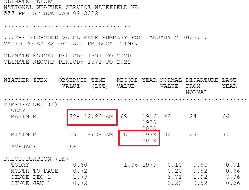
Also, let's be thankful we aren't sitting in the 70s after midnight anymore and setting record highs. BTW, record low of 10 was set just 4 years ago, although 10 is the highest record low for the entire month of January.
-
We could also be in late March and dealing with sun angle issues. This is the best threat for the area since January 2019.
-
Rates and time of day, if realized has depicted, should help mitigate that risk somewhat. I expect watches will be hoisted by tomorrow morning. We are basically 24 hours ago then.
-
Not sold until I see the Euro trend that way. Idea is there, but nothing like what the GFS is showing.
-
Nope, 33.
-
Might not make it. There was a slight wind most of the night. Maybe another shot tomorrow morning.
-
Officially logged in now.
-
Mid-Atlantic winter 2021-22 snowfall contest
RIC Airport replied to PrinceFrederickWx's topic in Mid Atlantic
BWI: 19.7" DCA: 24.5" IAD: 21.6" RIC: 26.8" Tiebreaker: LYH: 18.2" -
DCA: 11/15 IAD: 11/4 BWI: 11/05 RIC: 11/6 1.68"
-
Seeing some lightning bolts moving north out of NC on radar.
-
This is true, but at least they continue to get shafted. Although I don't think WE have fared as good as you would think with the NAO block we've had.
-
I feel so bad for those in the south-central, southern VA counties where thousands of people are still without power. :-( https://poweroutage.us/area/state/virginia
-
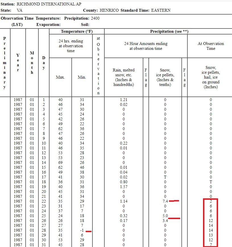
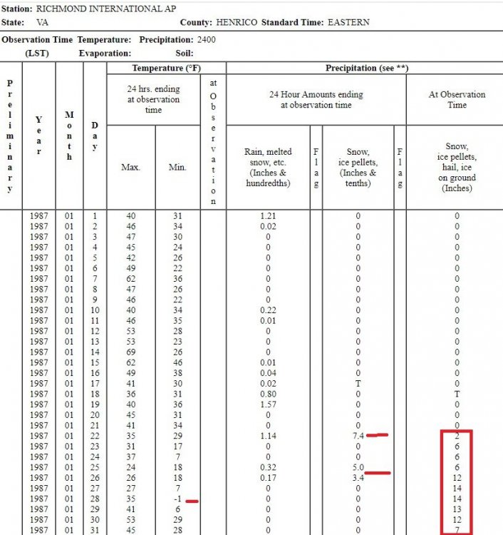
Little Rock has 16" on the ground after the 7.5 more inches fell there today. They just had their version of Richmond in January 1987. Back then, RIC had two snowstorms three days apart, a snow depth of a foot plus for like a week and temperatures that dropped below 0°F one day
-
It was PD II. Both are bad in their own way. You just won't get the massive power outages with sleet. During PD II, RIC was 20°F during the height of the event.
-
Meanwhile, we have to watch Dallas get a pure 6"+ snowstorm with temperatures in the low-mid teens.
-
Wow, that is crazy! Be safe.
-
The high at RIC was only 31°F, which happened at 2:06am. So the record streak above freezing is over!
-
Ah, that explains it. Well, feel free to chime in when you can the next time we get a notable weather event. Hope you like where you're living now.
-
It should be noted that the Ice Storm Warning is a product that didn't exist back when the AKQ WFO last needed it. NWS creates new products and discontinues others based on feedback from the public. For instance, Blizzard Watch and Freeze Watch, along with others, are no longer used as of a year or two ago. So, just because AKQ is using it for the first time, doesn't mean they wouldn't have back in 1998, 1994, etc.
-
This is great, I was wondering when you were going to come back in here, been a while!
-
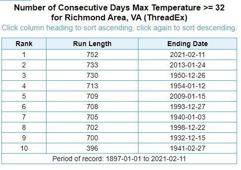
RIC has now gone 752 consecutive days with high temperatures above 32°F. This is the longest stretch on record. The last day to NOT rise above freezing was January 31, 2019 when the high temperature was 32°F. It will be interesting to see whether today or tomorrow can stay below freezing at the airport to end this streak. By the way, the average number of days with subfreezing highs for the 1991-2020 period of record is 5 days. 2020 and 2012 were the only two years with NO subfreezing highs.