RIC Airport
-
Posts
2,586 -
Joined
-
Last visited
Content Type
Profiles
Blogs
Forums
American Weather
Media Demo
Store
Gallery
Everything posted by RIC Airport
-
Richmond Metro/Hampton Roads Area Discussion
RIC Airport replied to RIC Airport's topic in Mid Atlantic
It actually looks like it's happening sooner. The precip just isn't heavy enough to cool the column sufficiently. KRIC started reporting rain at the onset but did go over to sleet.
-
Richmond Metro/Hampton Roads Area Discussion
RIC Airport replied to RIC Airport's topic in Mid Atlantic
Awesome! Glad they got to see some, even if it was brief. Hopefully there is more before this winter is over. -
Richmond Metro/Hampton Roads Area Discussion
RIC Airport replied to RIC Airport's topic in Mid Atlantic
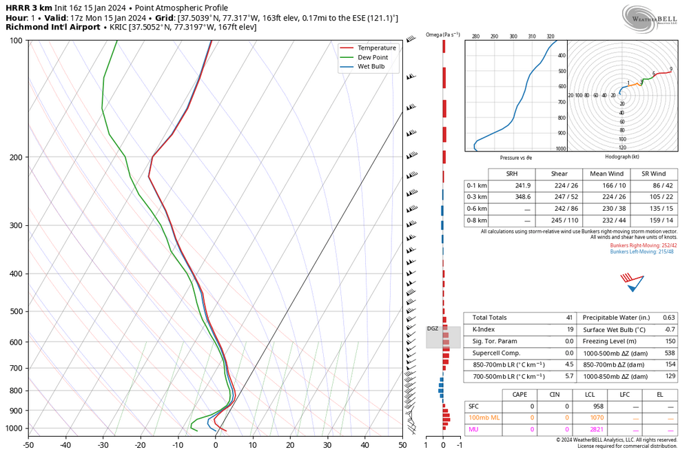
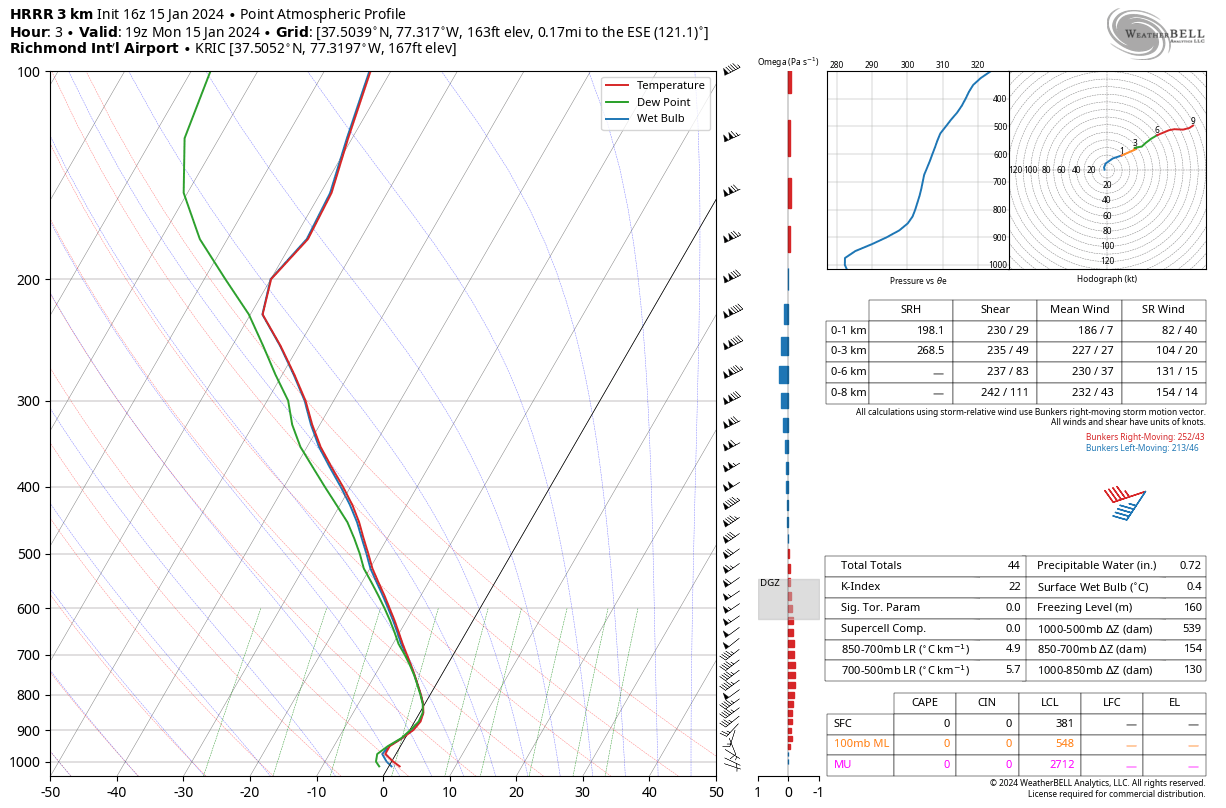
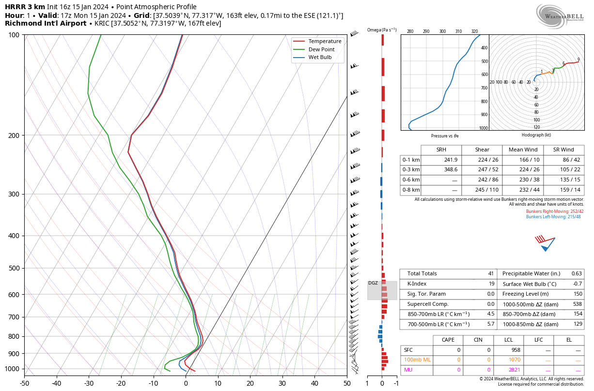
Only a tiny window left for any frozen at RIC. Per the sounding chart from the most recent HRRR, the surface temp never gets below freezing. By 2pm, it already has dewpoint and wet bulb above freezing so any precip at that point would be rain.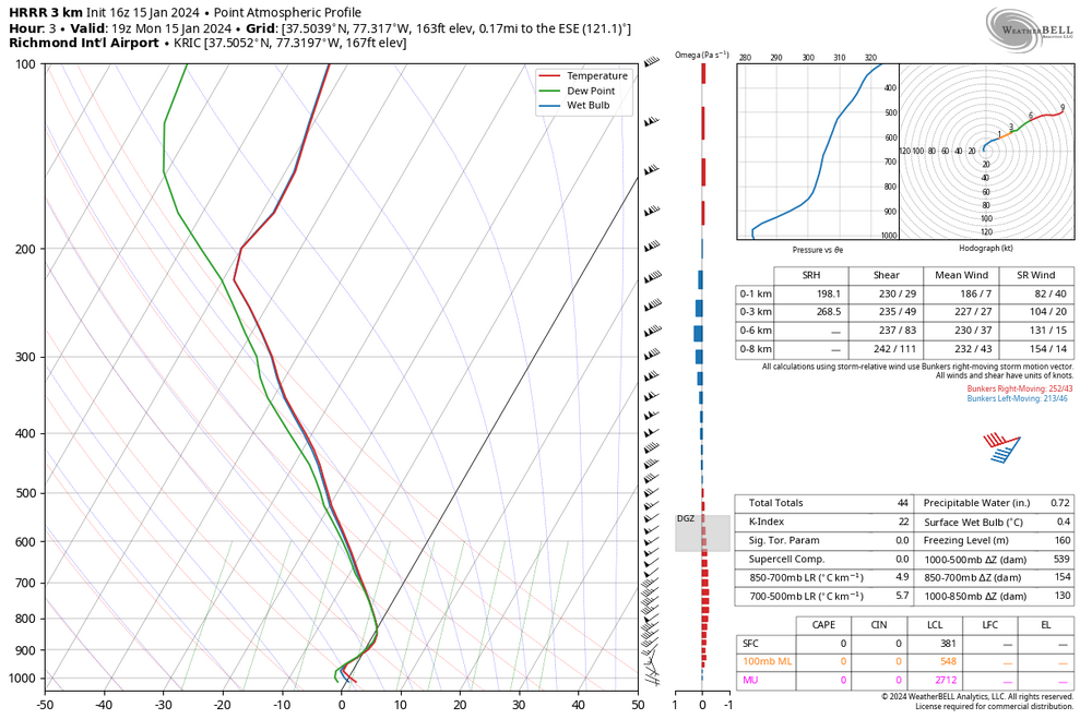
-
Richmond Metro/Hampton Roads Area Discussion
RIC Airport replied to RIC Airport's topic in Mid Atlantic
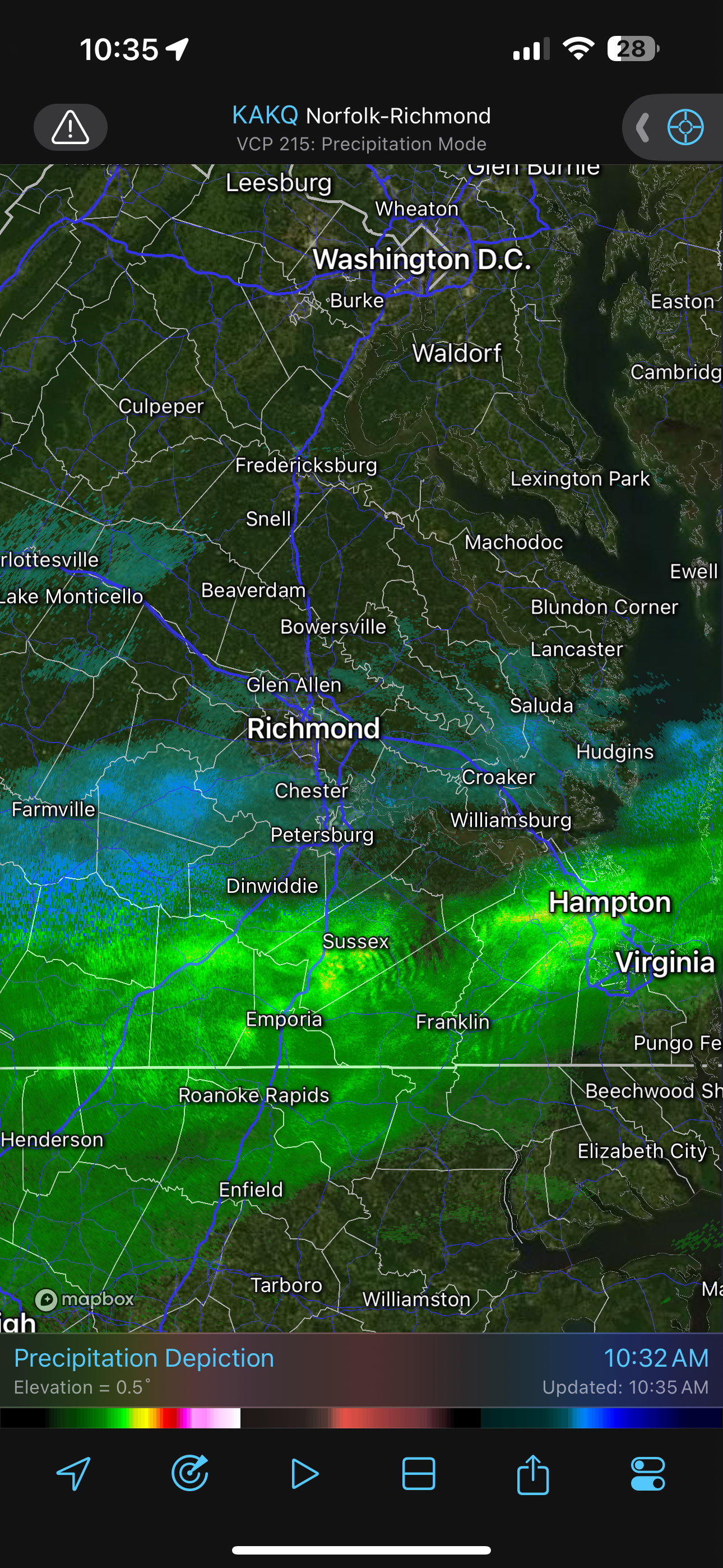
I just tried looking around Emporia, and the roads look wet, but the camera is too grainy to know that it's rain, snow....or even sleet. That is probably what the yellow colors are picking up that way. https://www.weatherbug.com/traffic-cam/?latlng=36.7029,-77.5497&camId=430919&fbclid=IwAR1ReRnrZczKGm12u22Y7P1qTxNGyC7b4wQxK8UGrzwAeGBaoHGiip7FqH8 Also, the AWOS appears to be down, lol. https://www.weather.gov/wrh/timeseries?site=kemv -
Richmond Metro/Hampton Roads Area Discussion
RIC Airport replied to RIC Airport's topic in Mid Atlantic
Definitely activity to the south of Richmond. It has that SW to NE orientation, but the band looked to be lifting north. So, I imagine precip should begin in the next couple of hours. Dew points are in the low-mid teens, and temps are in the mid-30s, but this band looks heavy enough to wet bulb us to freezing or below, hopefully. As long as the entire column is below freezing. And yes, better to see the band forming south of us than right over,@wasnow215.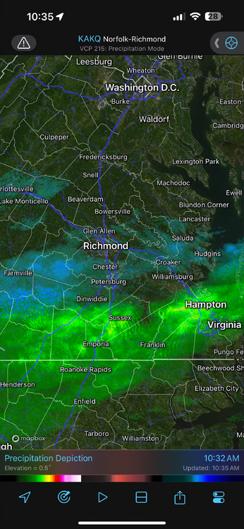
-
Richmond Metro/Hampton Roads Area Discussion
RIC Airport replied to RIC Airport's topic in Mid Atlantic
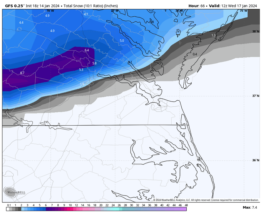
The 00z GFS was also a step back from earlier runs, but it didnt completely shut out RIC. Still on that southern fringe, though, which is never a good place to be.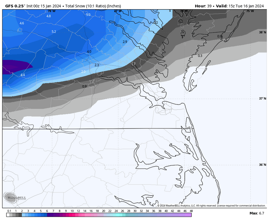
-
Richmond Metro/Hampton Roads Area Discussion
RIC Airport replied to RIC Airport's topic in Mid Atlantic
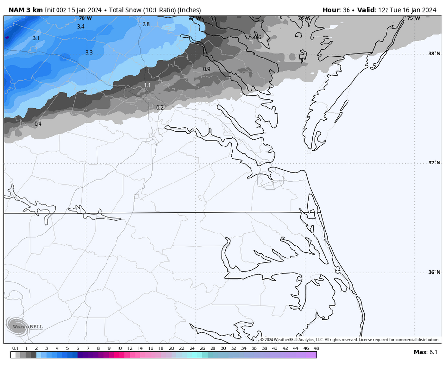
The 00z short term models have not been friendly. The snow band has shifted primarily north of Richmond.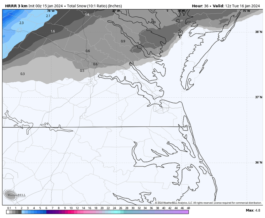
-
Richmond Metro/Hampton Roads Area Discussion
RIC Airport replied to RIC Airport's topic in Mid Atlantic
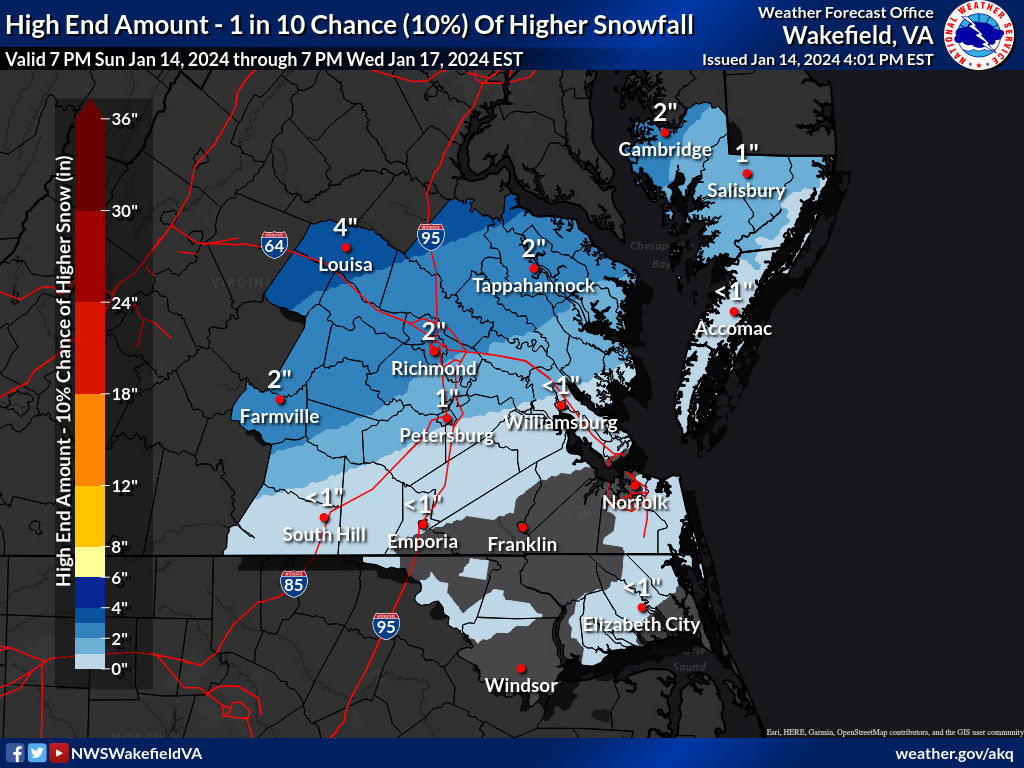
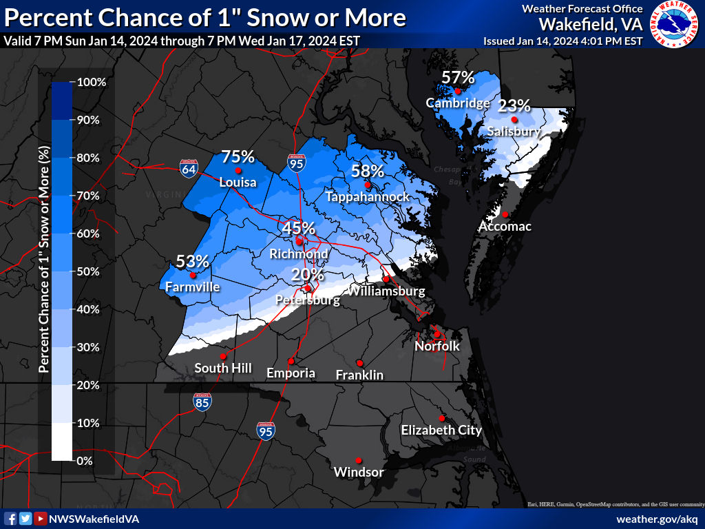
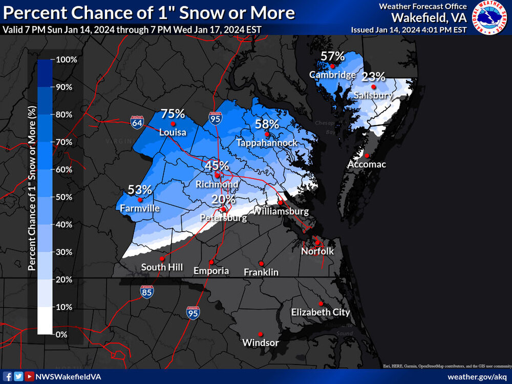
AKQ issued an advisory and also ticked up totals a bit.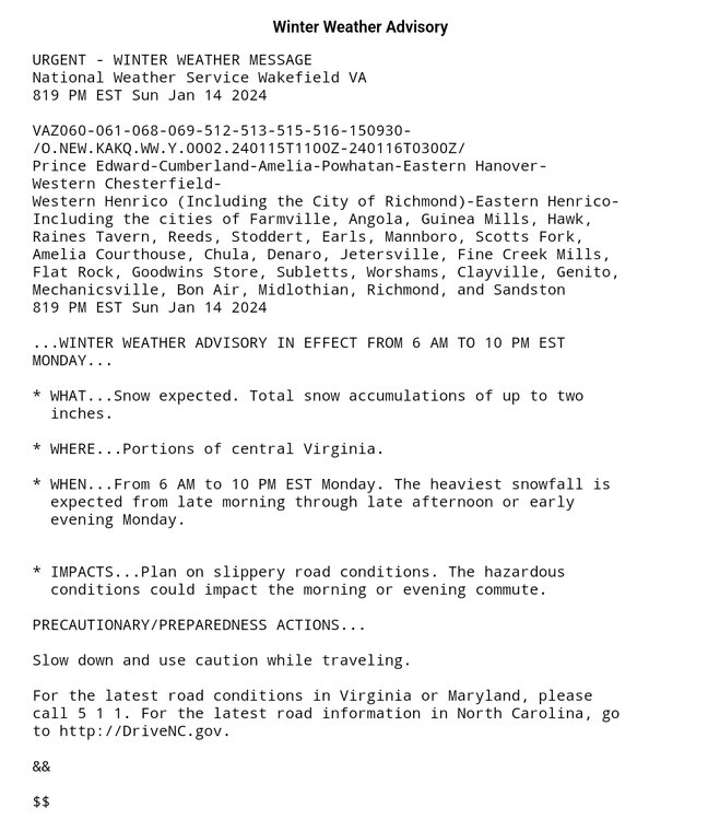
.thumb.jpg.6e5bbe11e3fc506bf785c2dc67f0f843.jpg)
.png.2aeecd46361ab38a10fadd022bab9db3.png)
-
Richmond Metro/Hampton Roads Area Discussion
RIC Airport replied to RIC Airport's topic in Mid Atlantic
Here is the latest disco and the maps from Wakefield. I bolded part of the disco, highlighting what many of us mentioned earlier. .NEAR TERM /UNTIL 6 AM MONDAY MORNING/... As of 410 PM EST Sunday... Late this aftn, an arctic cold front was pushing through the nrn third of the area, with just sctd SC and AC associated with the front. Otherwise, the sky was sunny or mostly sunny across the region with temps ranging from the mid 40s to the upper 50s. Winds were still gusty in advance of and behind the front with gusts to 30-35 mph. Winds become light tonight, as weak high pressure moves in with lows in the mid 20s N, to the lower to mid 30s SE under increasing and lowering clouds. Although high pressure begins to build in, it remains centered over the central CONUS with an elongated, zonal shortwave stretching from TX into VA. Hi-res CAMs now show enough forcing and moisture aloft due to this feature for at least some virga and perhaps isolated to sctd light snow showers forming late tonight across the NW half of the FA. However, the airmass near the sfc will start off very dry with dew points potentially in the single digits this evening. As such, it may take awhile for moisture aloft to saturate the profile enough for snow to make it to the ground. But, do now have 15-35% PoPs for nrn/WNW portions of the region from 6-12z Mon with a light dusting possible. && .SHORT TERM /6 AM MONDAY MORNING THROUGH WEDNESDAY/... As of 410 PM EST Sunday... Elongated shortwave energy and increasing moisture and lift will expand over the nrn two thirds of the area Mon into Mon evening. PoPs quickly increase to 40-60% in these areas, as a band of snow develops later Mon morning into early Mon aftn, then shifts NNW later Mon aftn into Mon night. Most of the pcpn should fall as snow, although rain may mix in or become the dominant pcpn type across the SE portion of the FA during the aftn and evening when temps rise. Speaking of temps, temps will be cold with highs only in the lower to mid 30s NNW, to the upper 30s to mid 40s SSE. It is possible that the NW half of the FA doesn`t make it above freezing if snow continues through the day due to dynamic cooling. A weak surface low forms off the SE coast late Mon night, before moving NE off the Mid Atlc coast and twd the nrn Atlc Tue morning into Tue night. While this low is expected to remain weak, it may add enough moisture for PoPs to increase to 50-70% across ENE portions of the FA Tue morning into early Tue aftn. However, temps warm above freezing on Tue with a transition to rain/snow across the NNW half of the FA and mainly rain everywhere else. Pcpn will move offshore or end Tue evening/Tue night, with gradual clearing from NW to SE by Wed morning. Total snowfall amts have now increased for this event, with 1-3 inches possible across the NNW third of the FA with 0.5-1.0 inch across the central third, and little to no accumulation across the SE third. These totals may change as we get closer to the event given uncertainties still with the evolution of the moisture/lift, timing and placement. But, based on this latest fcst, will likely be issuing Winter Weather Advisories this evening for at least nrn/NW counties for the accumulating snow possible. Highs Tue in the upper 30s NNW, to the mid 40s to lower 50s SE. Very cold air moves in behind the low Tue night with lows in the mid to upper teens across much of the area, and in the lower to mid 20s SE and along the coast. This will allow for wind chills in the single digits across the N and W areas, and 10-15F across the SE late Tue night/Wed morning. Sunny or mostly sunny and cold on Wed, as high pressure builds into the region. Highs only in the mid to upper 30s.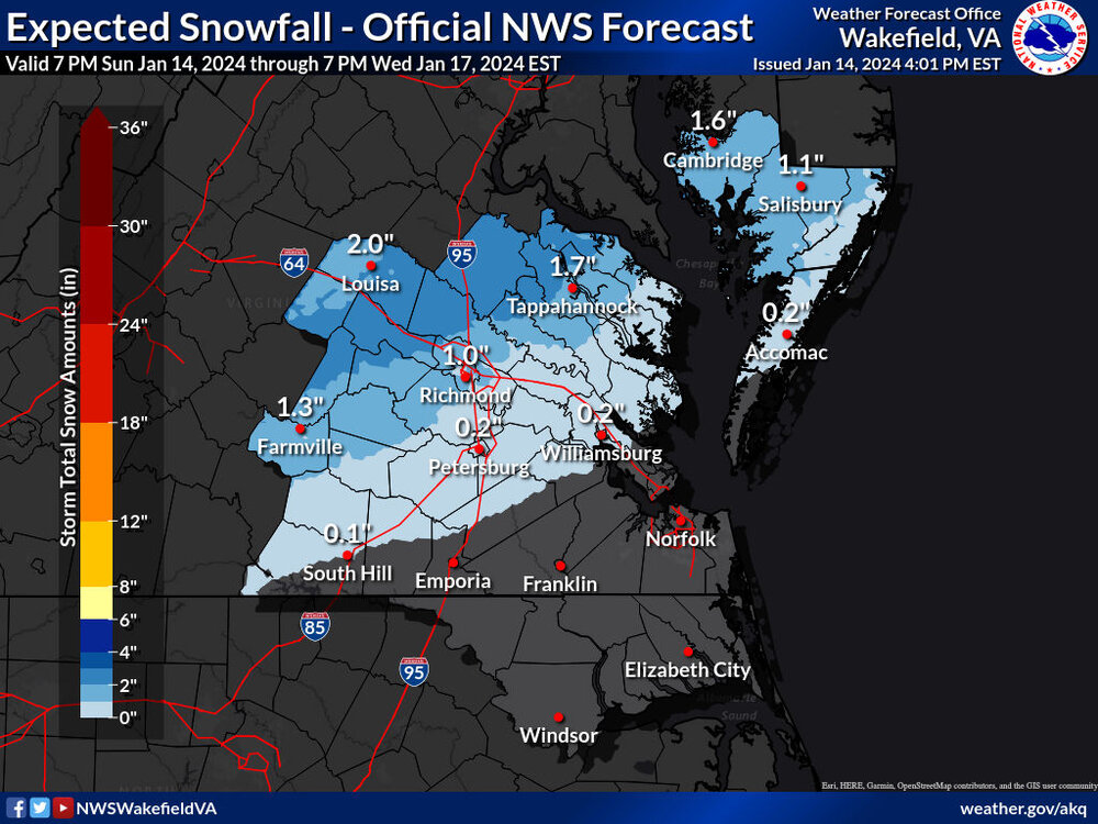

-
Richmond Metro/Hampton Roads Area Discussion
RIC Airport replied to RIC Airport's topic in Mid Atlantic
For@ldub23 and other Hampton Roads folks.
-
Richmond Metro/Hampton Roads Area Discussion
RIC Airport replied to RIC Airport's topic in Mid Atlantic
I agree that we should keep that in mind. There are different scenarios on the table and it'll be interesting to see which model does the best. -
Richmond Metro/Hampton Roads Area Discussion
RIC Airport replied to RIC Airport's topic in Mid Atlantic
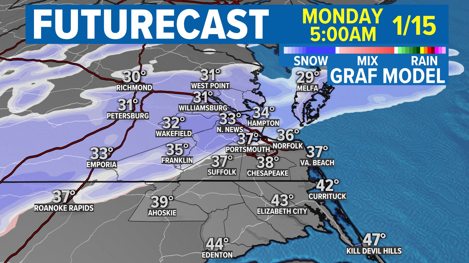
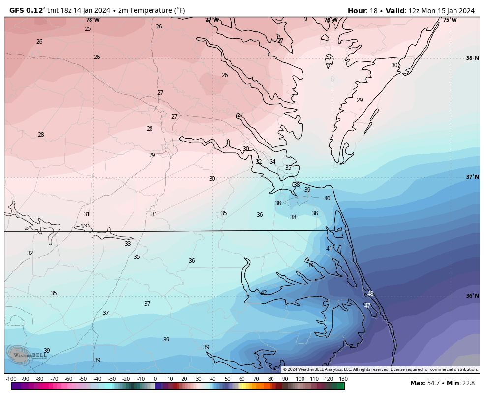
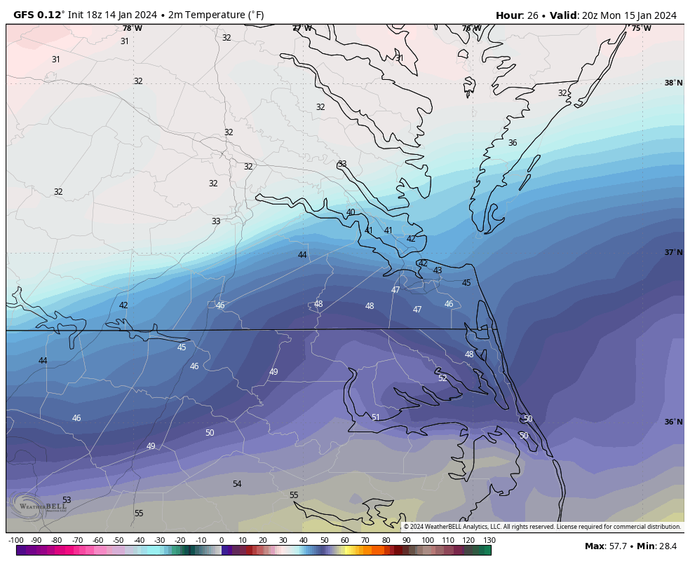
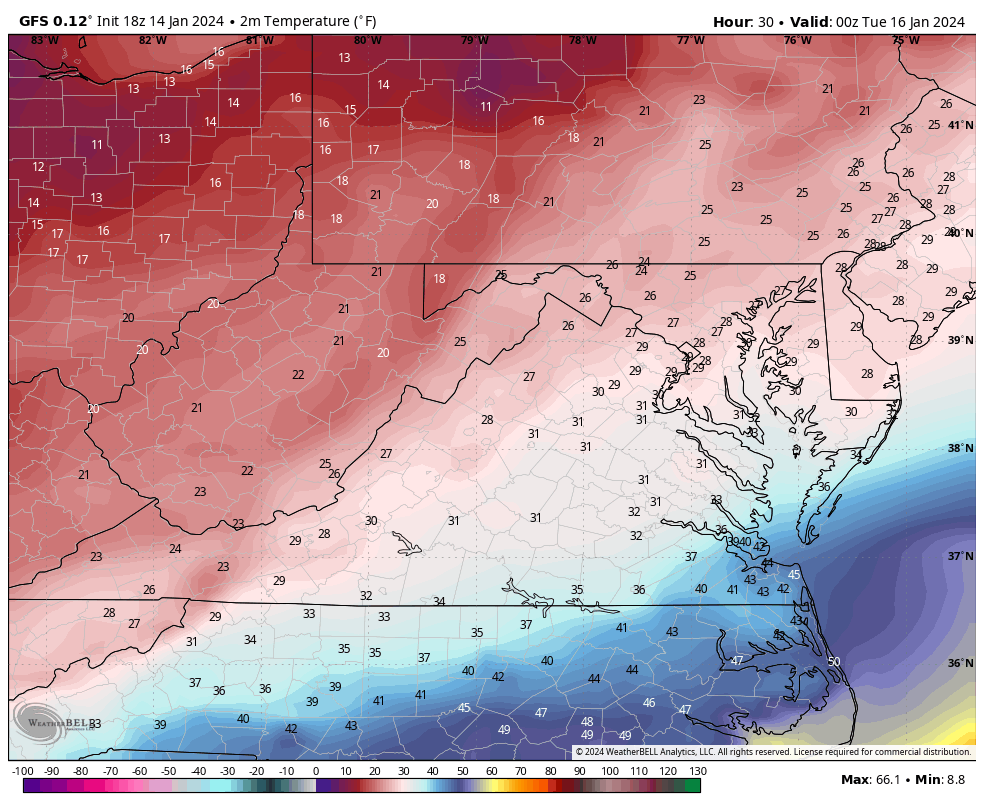
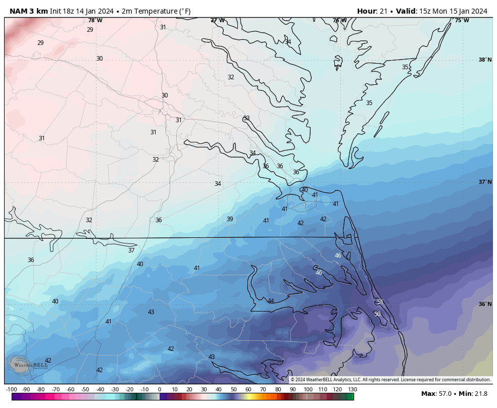
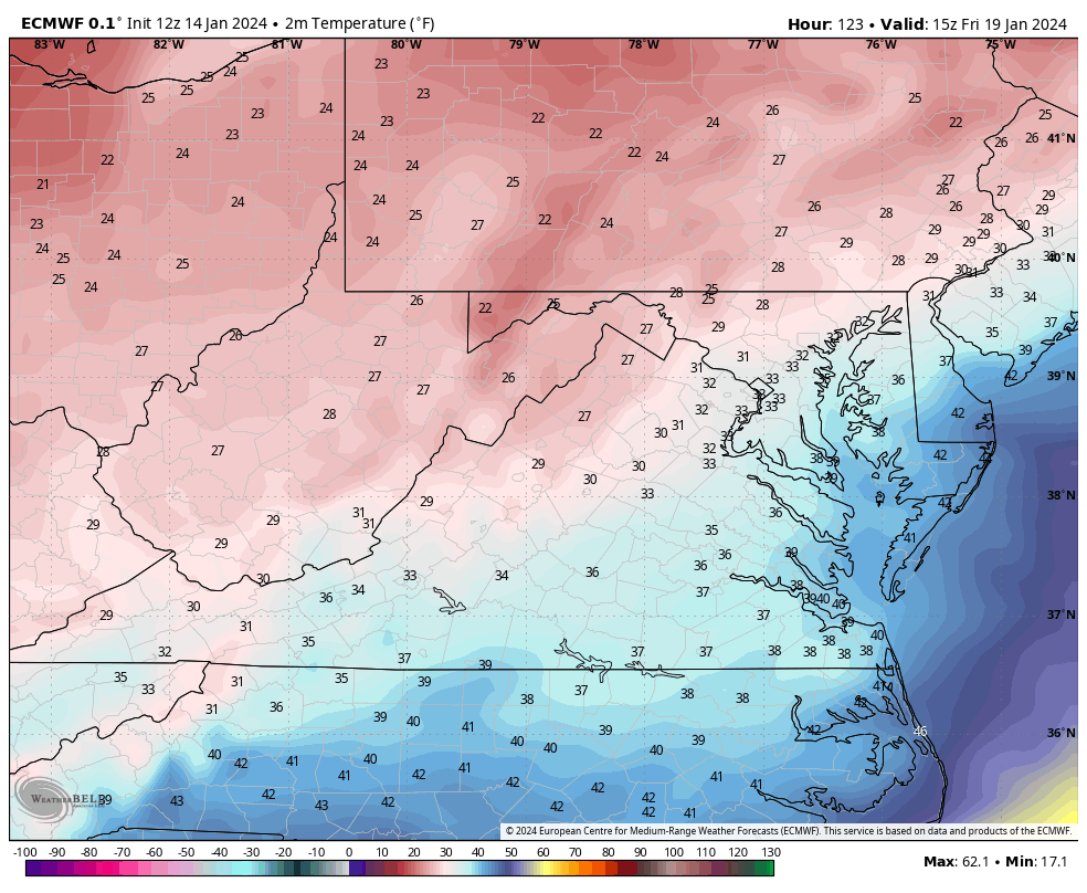
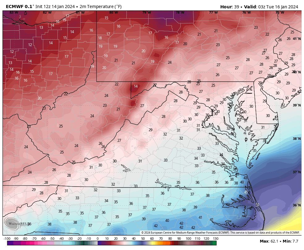
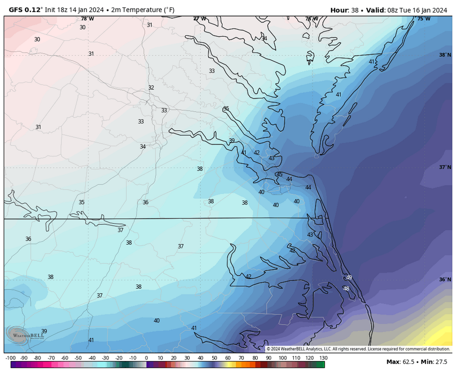
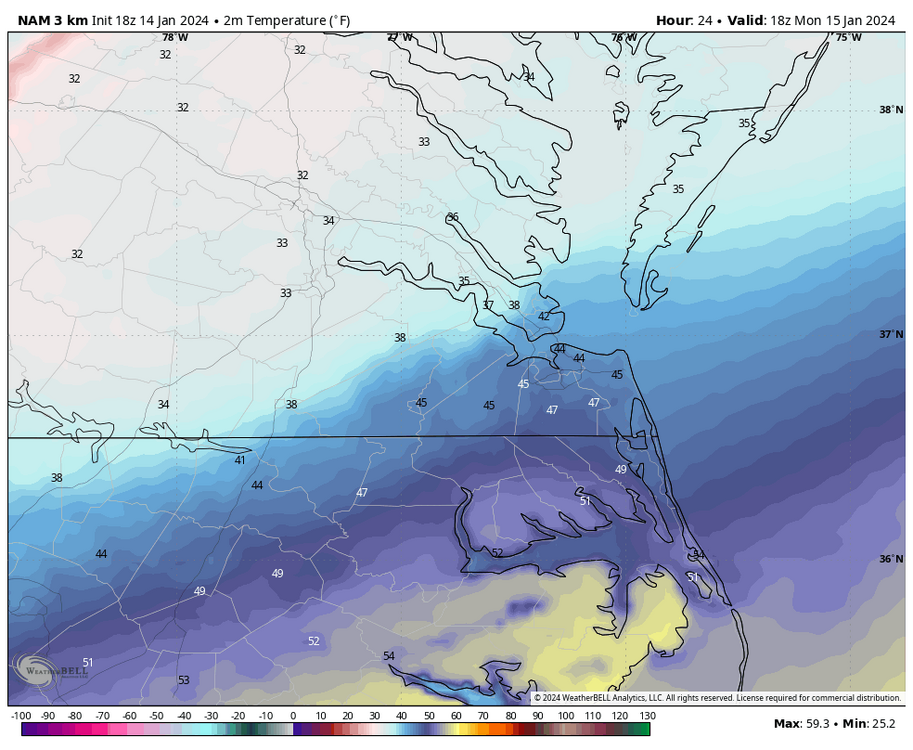
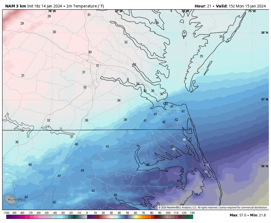
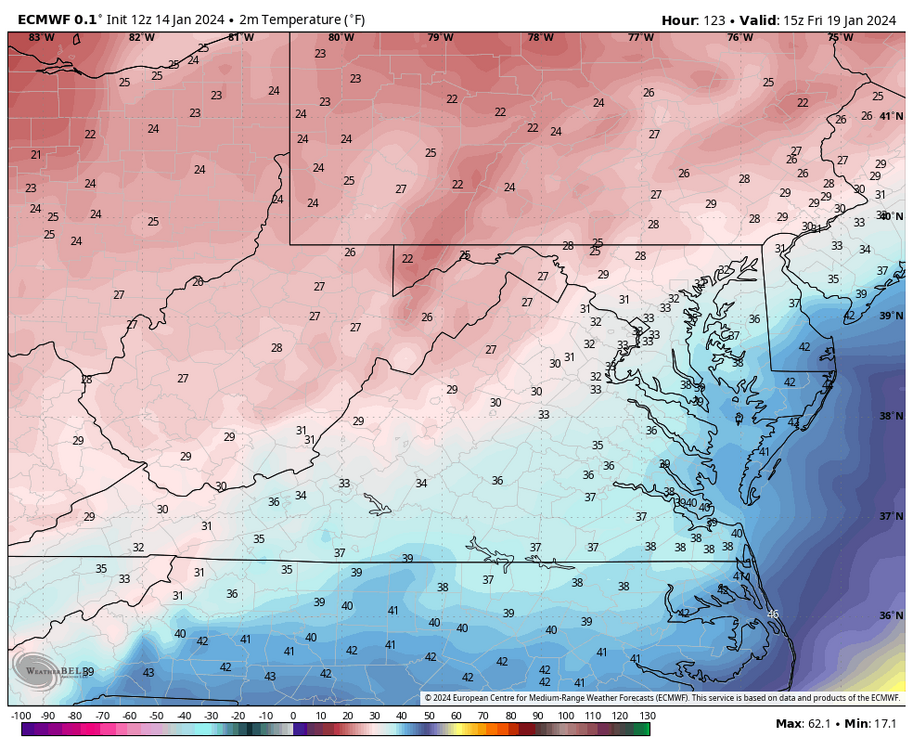
@wasnow215I should caveat by saying, that does not mean RIC can't rise above freezing in an intrahour reading, especially tomorrow afternoon around the time of the 20Z (3pm) temp map below.

-
Richmond Metro/Hampton Roads Area Discussion
RIC Airport replied to RIC Airport's topic in Mid Atlantic
18Z for that hour was a degree colder. 31°F vs 32°F.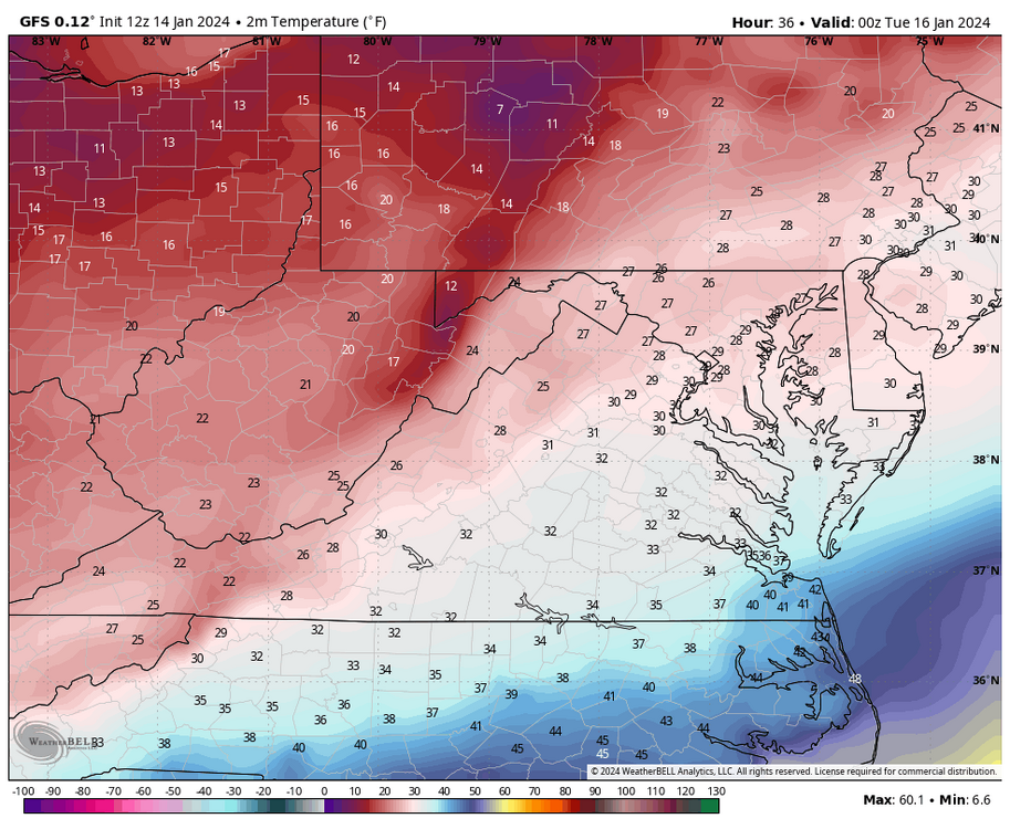

-
Richmond Metro/Hampton Roads Area Discussion
RIC Airport replied to RIC Airport's topic in Mid Atlantic
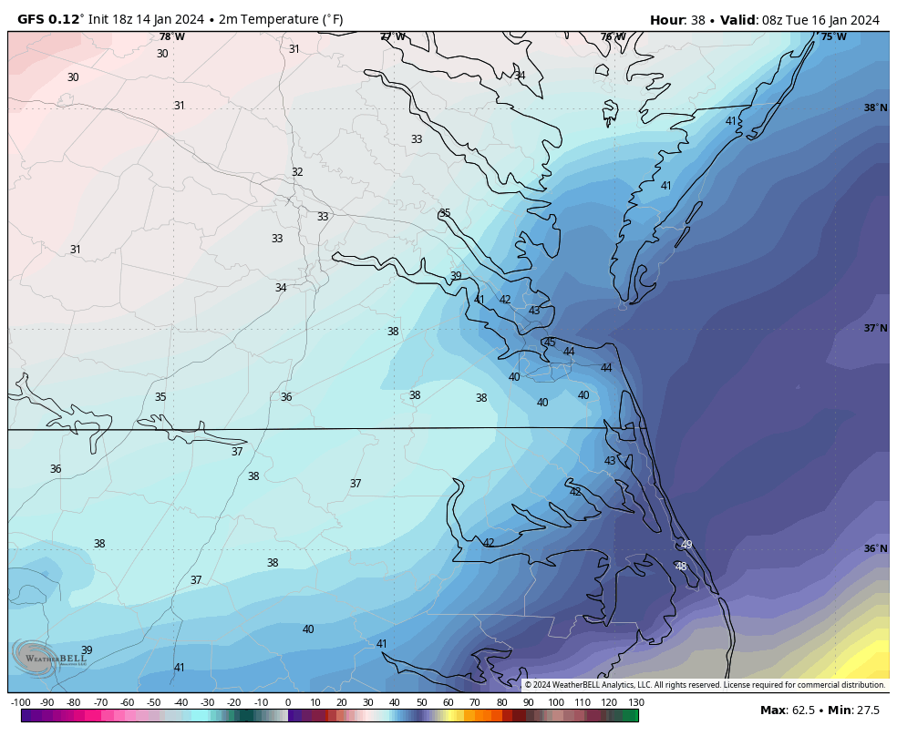
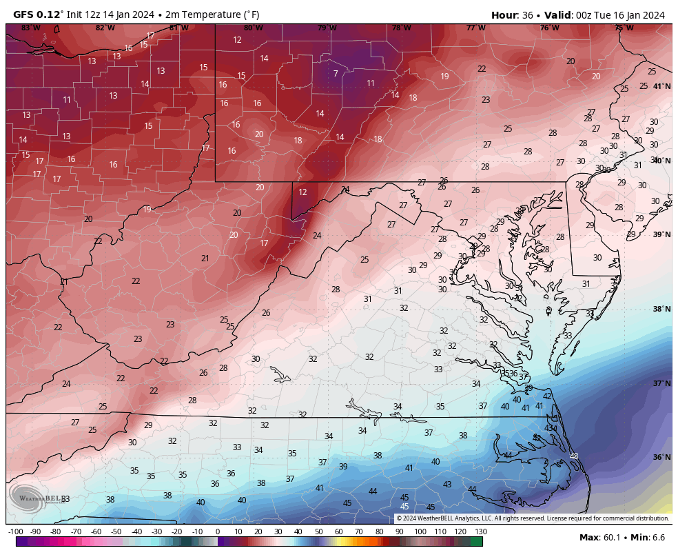
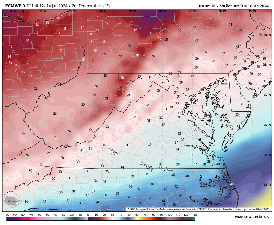
The 18Z GFS, like the 12Z, was cold throughout. RIC was at 46°F at 5pm. It puts RIC at 32°F at 2am tonight. I am not seeing a temp above freezing until 3am Tuesday morning. -
Richmond Metro/Hampton Roads Area Discussion
RIC Airport replied to RIC Airport's topic in Mid Atlantic
-
Richmond Metro/Hampton Roads Area Discussion
RIC Airport replied to RIC Airport's topic in Mid Atlantic
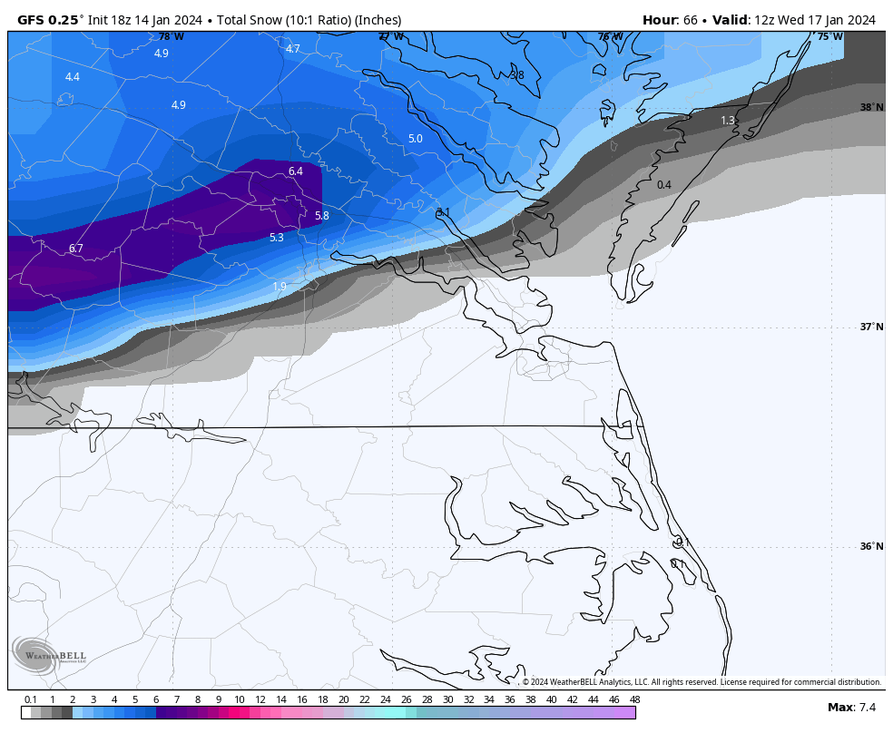
18Z GFS as it's coming in, is similar to 12Z, @Conway7305, @wasnow215, @eaglesin2011, @SoCoWx -
Richmond Metro/Hampton Roads Area Discussion
RIC Airport replied to RIC Airport's topic in Mid Atlantic
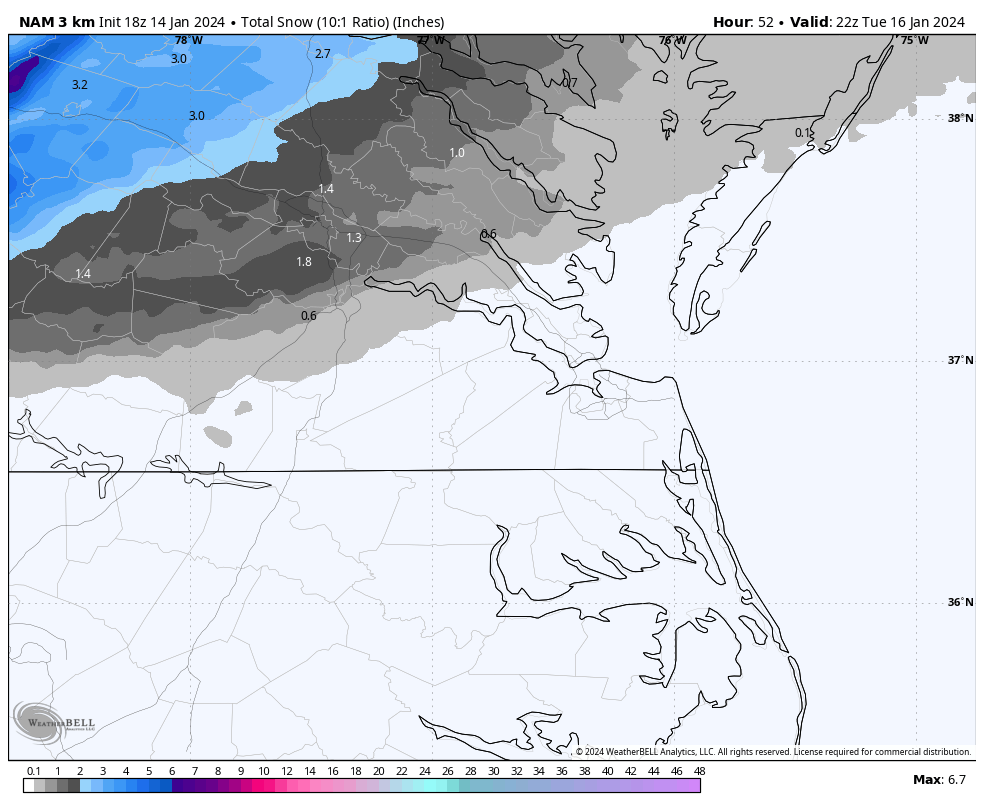
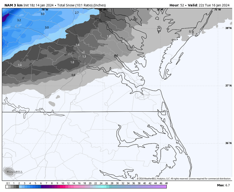
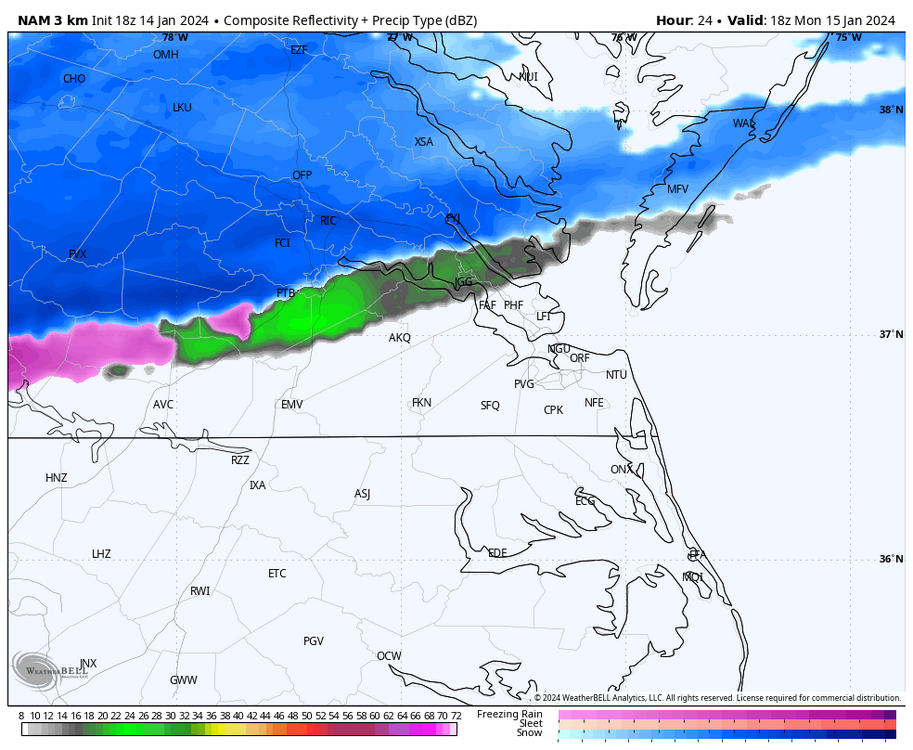
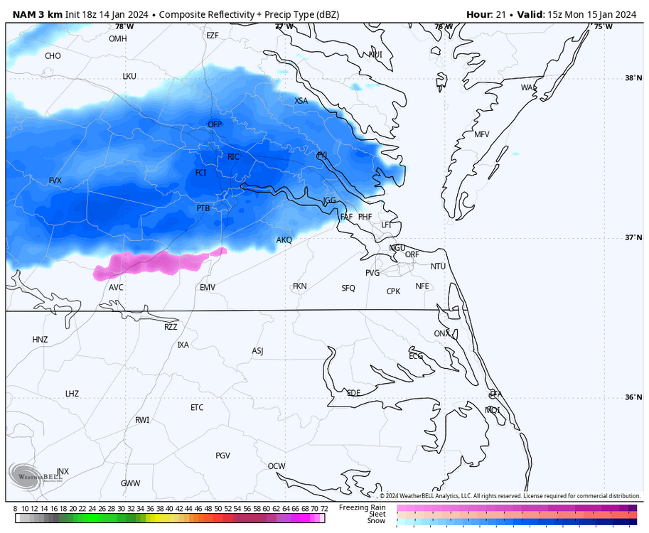
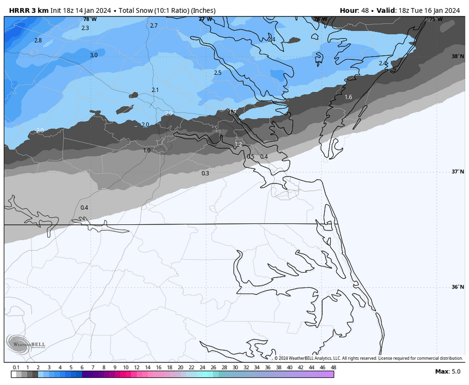
@wasnow215, The 18Z 3K NAM is similar to the 18z HRRR. Both models have a very early arrival of precip between 4am and 5am, with the heavier rates of snow arriving between 8am and 10am and lasting until about 3 or 4pm. It's around this time that precip tapers off, and surface temps remain above freezing while we are dry-slotted. As it pulls away, there could be additional rain overnight and early Tuesday from the coastal low. 3K NAM has RIC below freezing until about 11am, so ratios could drop, and snow may not accumulate as well, even though precip rates are higher into the mid afternoon.
-
Richmond Metro/Hampton Roads Area Discussion
RIC Airport replied to RIC Airport's topic in Mid Atlantic
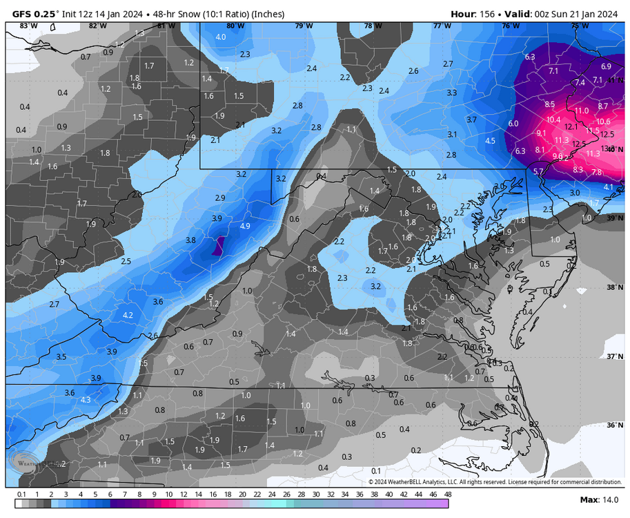
I am concerned about surface temperatures and worried that the snow band could position farther north and Richmond is fringed without meaningful amounts. Meaningful being like 1”+. The goal is getting 1” at the airport to end the snowless streak. The 18Z HRRR has precip arriving tomorrow morning with surface temps around 31-32°F as the snow begins. The radar simulation shows some snow trying to start during the wee hours of the morning, but it’s probably just virga (maybe). Either way, HRRR has the bulk of the snow entering Richmond between 8am and 9am. Rates pick up, but it has snow changing to rain between 4pm and 5pm as temperatures rise to about 35-36 °F. The good news is that the bulk of the precip is over by this time. It just may mean that any snow that falls could be melted by afternoon. Then we get dry slotted and may get additional rain late Monday night into Tuesday as the coastal low gets going and starts to pull away Let’s hope the 12Z GFS is correct, but my gut feeling is that the 12Z run was too aggressive with snow.
-
Richmond Metro/Hampton Roads Area Discussion
RIC Airport replied to RIC Airport's topic in Mid Atlantic
@Conway7305, @ldub23Friday's storm was basically a snowstorm for 40N, although it does have a portion of C VA, starting off as snow between about 4am to 10am Friday morning before changing to rain. We are on the southern fringe of the entire thing. Still something to monitor in the coming days, I guess. Would be wonderful to get TWO accumulating events within a week.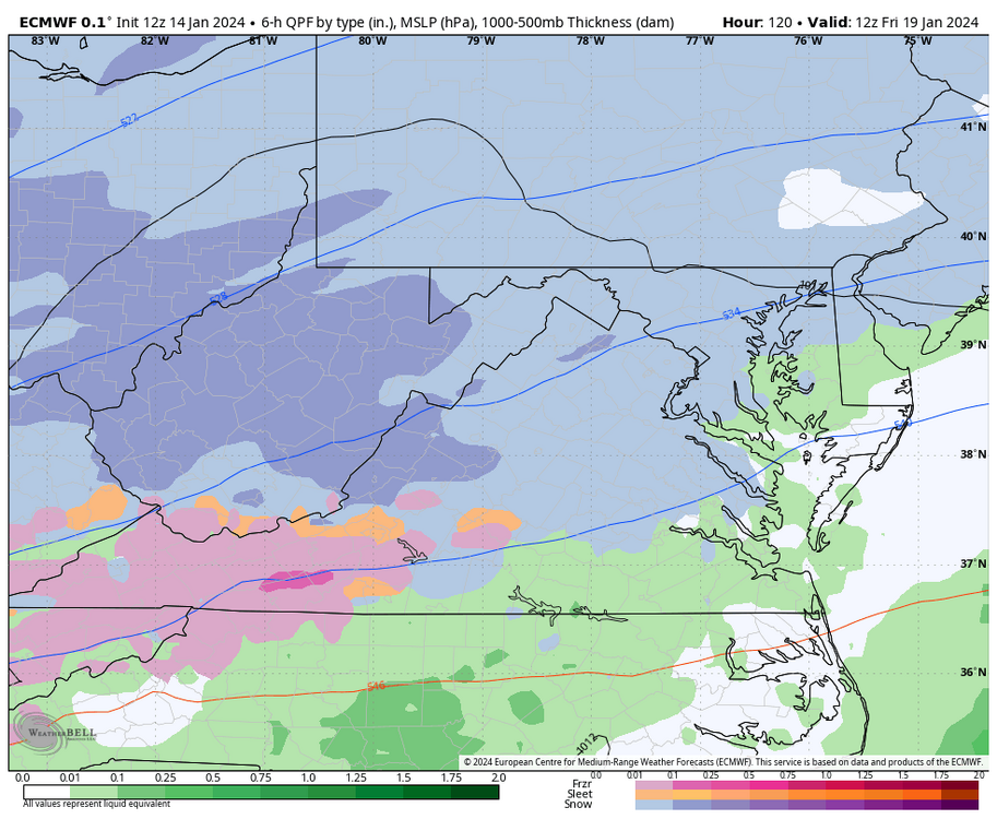


-
Richmond Metro/Hampton Roads Area Discussion
RIC Airport replied to RIC Airport's topic in Mid Atlantic
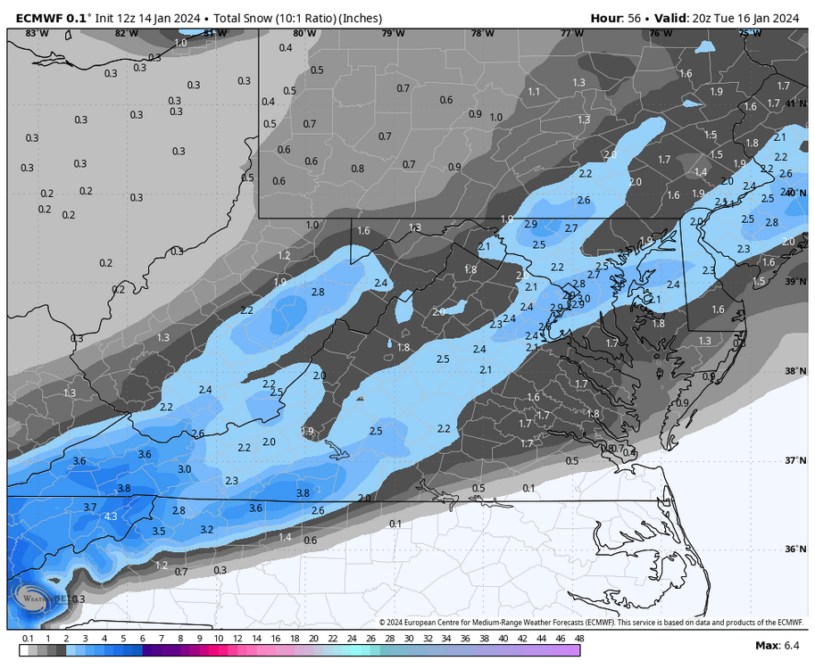
The 12Z Euro has the snow band arriving tomorrow morning, but the bulk of the precip doesn't enter the Richmond area until around 3 or 4 pm The heavier rates from north to south are between 7pm and 1am. Surface temperatures are above freezing when the precipitation starts but drop near freezing as the snow begins. The snow band didn't hang around as long as the GFS did before lifting north. GFS has an earlier arrival of the snow (heavier rates), which helped keep surface temperatures lower.


-
Richmond Metro/Hampton Roads Area Discussion
RIC Airport replied to RIC Airport's topic in Mid Atlantic
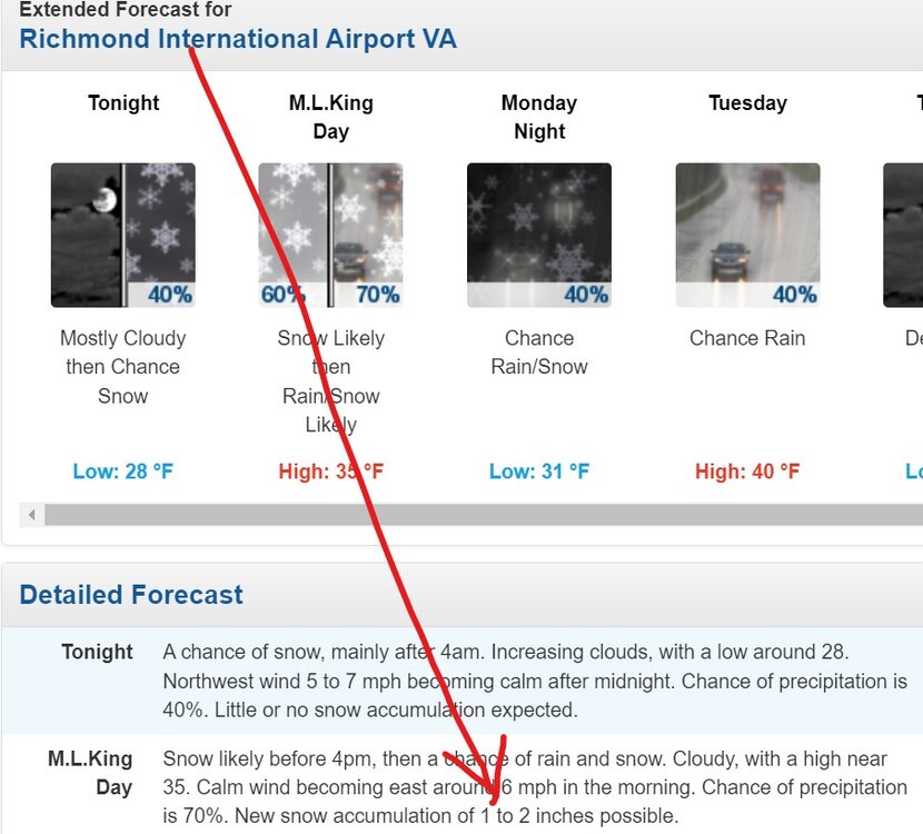
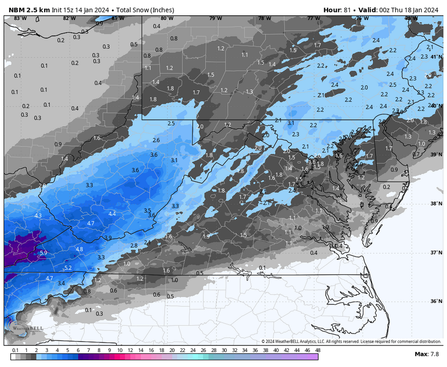
Here is the National Blend of Models (NBM). It runs every 3 hours, and it's basically a time-lagged blend of at least a few dozen models and ensembles. It still likely has some 06z or earlier guidance. It slowly responds if guidance continues to trend up or down, but it's what the NWS uses and should correlate to what you see in your point-and-click forecast. FWIW, here are the last two runs.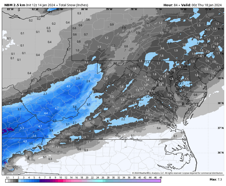
-
Richmond Metro/Hampton Roads Area Discussion
RIC Airport replied to RIC Airport's topic in Mid Atlantic
I like how the over-running from the initial wave seems to be "trending." Of course, some models have fluctuated with how far south it developed. The farther south, the better for us, and maybe even as far SE as Newport News/Hampton. Some models have the band advancing north into NoVa and dry-slotting us quickly, while others have it lingering longer around Richmond. Some models have surface temp and 850/925mb temp issues for parts of the Richmond area, while others have the column below freezing for the entire initial wave. Also, the timing of the precip is slightly different from model to model. What was a Tuesday event is now solidly a Monday one on some. I am not a pro, but I imagine trying to put out a forecast would be frustrating. I have given up hope on the coastal low. It could enhance precip to an extent, but I agree that most of the precip is from the initial wave vs the coastal. -
Richmond Metro/Hampton Roads Area Discussion
RIC Airport replied to RIC Airport's topic in Mid Atlantic
12Z still had it. Actually, the past few runs of the GFS. I want to get excited once the Euro catches on, which is possible. I noticed the 6Z EPS improved from the 00z EPS for Friday. But, since 6z EPS only goes out to hour 144, it only captured some of the event.
-
Richmond Metro/Hampton Roads Area Discussion
RIC Airport replied to RIC Airport's topic in Mid Atlantic
Thank you, nice to wake up to a jackpot run.
-
Richmond Metro/Hampton Roads Area Discussion
RIC Airport replied to RIC Airport's topic in Mid Atlantic
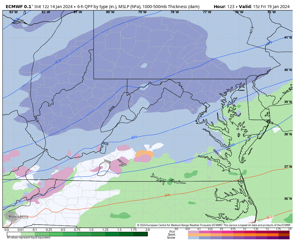
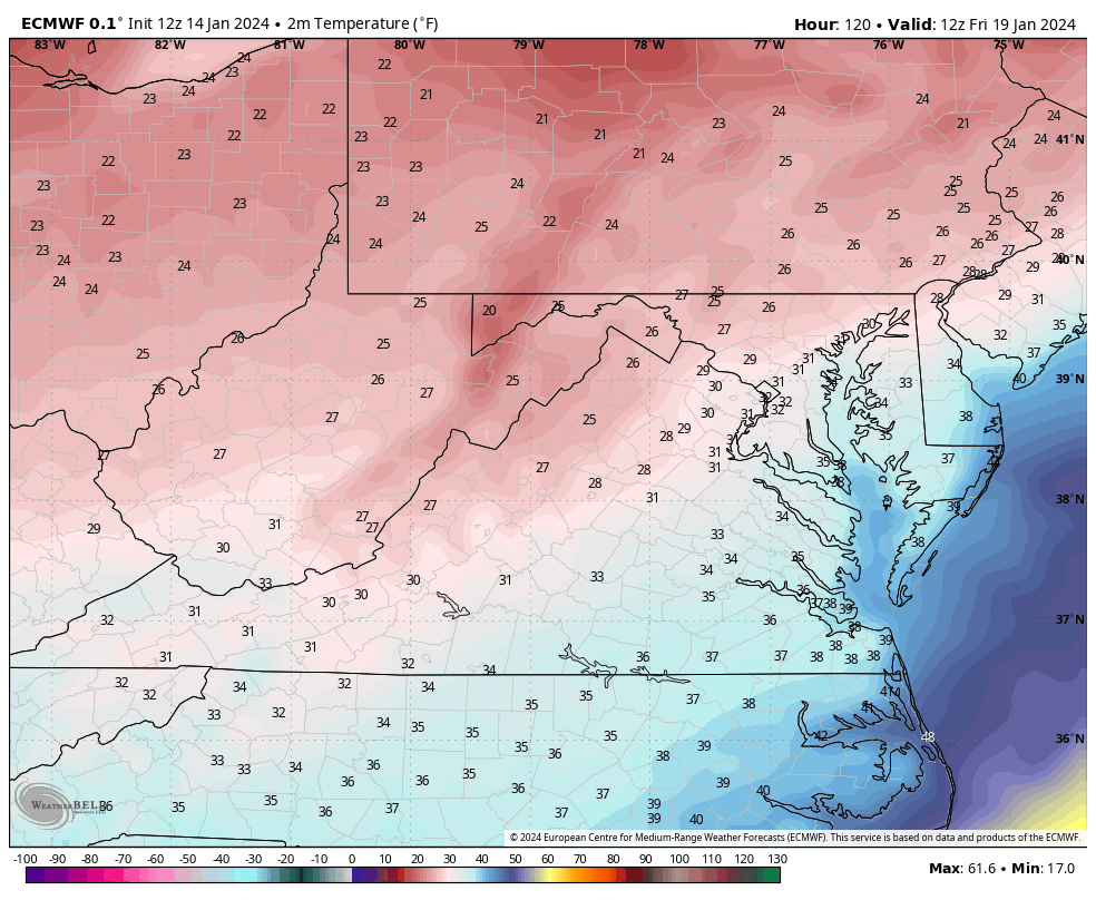
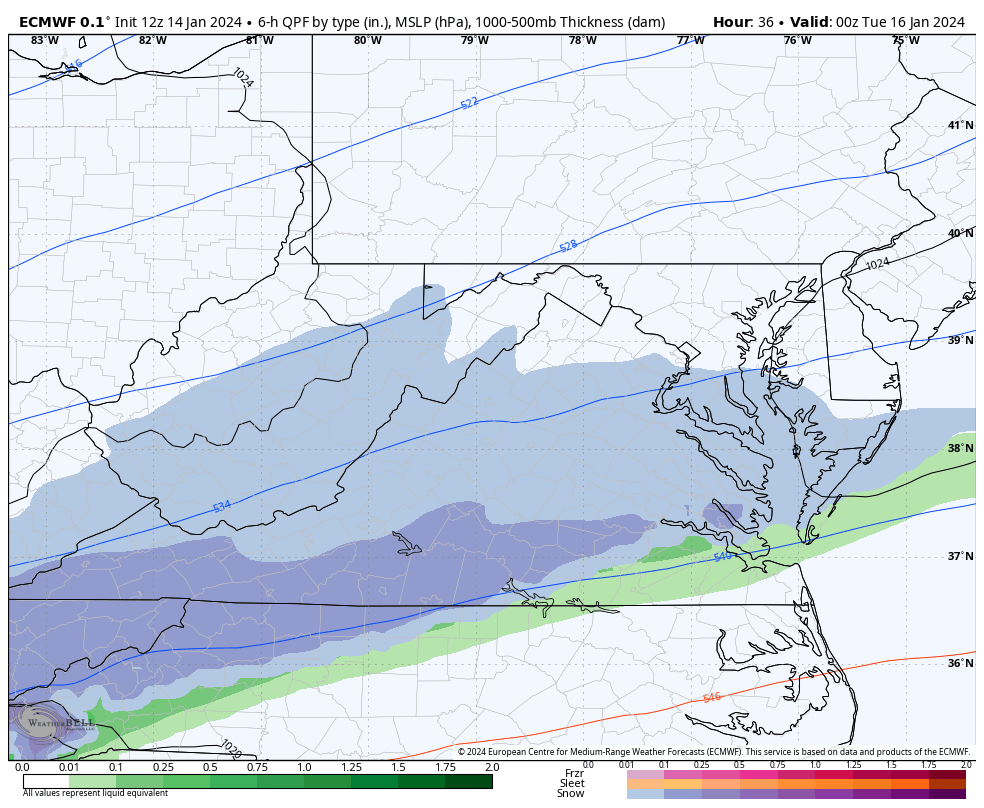
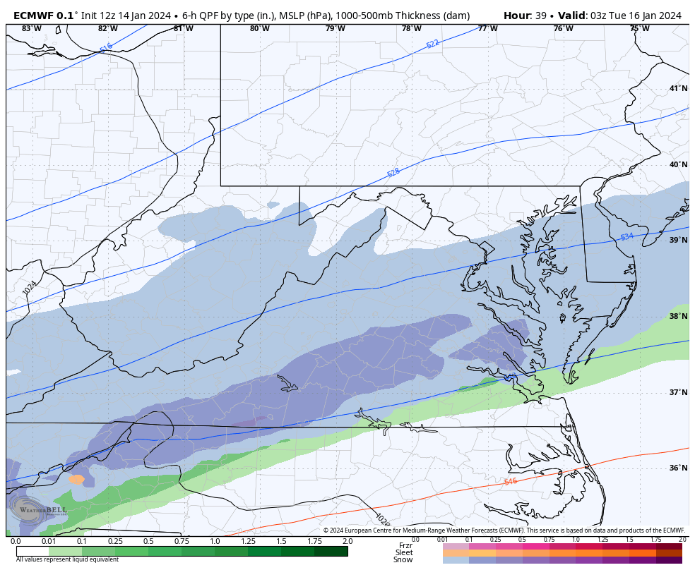
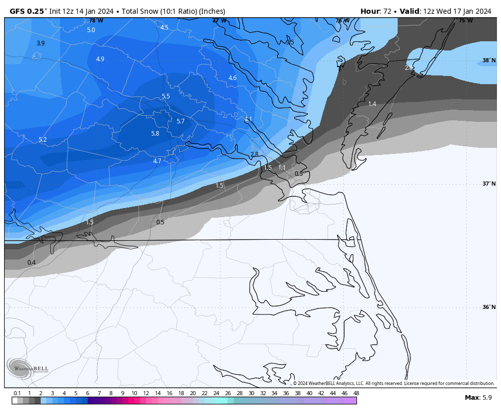
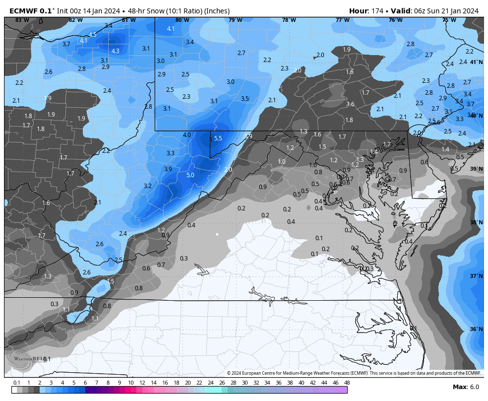
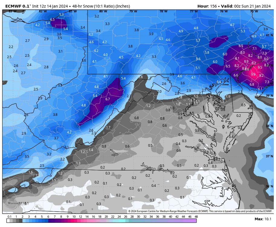
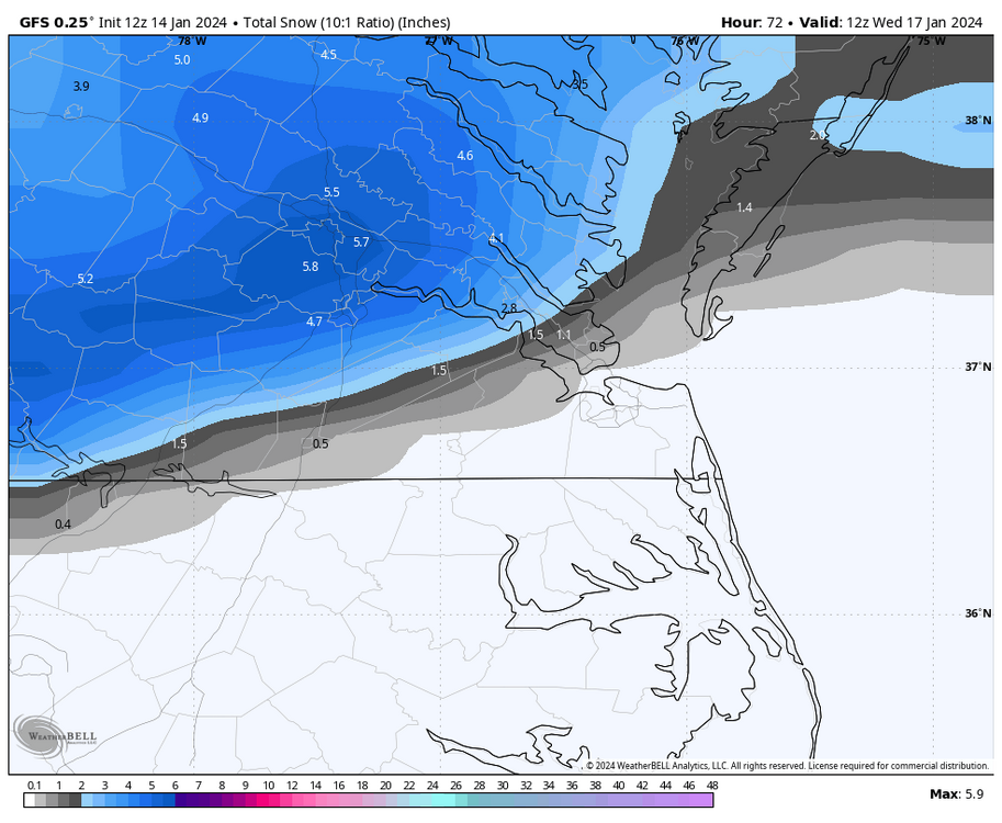
The 00Z Euro is similar to other models in that it has the initial snow band developing Monday over the Richmond metro and quickly moving north. Some rain could fall on the southern end of the band south and east of Petersburg and West Point. Euro has the bulk of the precip moving into the metro area after about 7 or 8pm, but it only hangs around for about 5-6 hours before taping off. Euro was also warm at the surface (33-34°F) around Richmond, so unless there are good rates, it could make accumulations more difficult. It's looking more like the DC metro area could be the winner with this wave. Light rain spreads over Hampton Roads and NE NC Tuesday morning into the afternoon as the coastal low develops and begins to pull away. The Euro also had the Friday storm, but the snow was confined to NoVA and basically became a 40N storm. But it is something to monitor in the next couple of days.
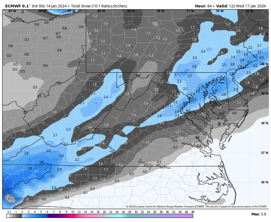

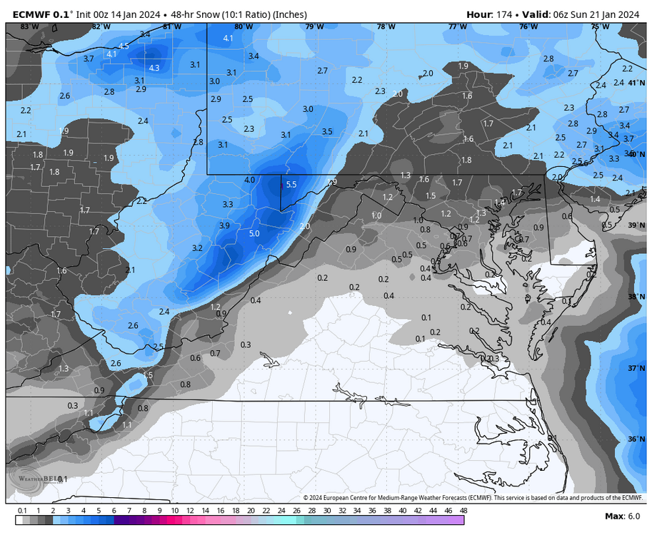


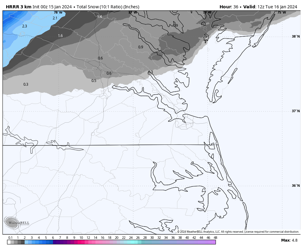


.jpg.01e7bef906dd6960221f919a2ba796f5.jpg)