RIC Airport
-
Posts
2,586 -
Joined
-
Last visited
Content Type
Profiles
Blogs
Forums
American Weather
Media Demo
Store
Gallery
Everything posted by RIC Airport
-
Richmond Metro/Hampton Roads Area Discussion
RIC Airport replied to RIC Airport's topic in Mid Atlantic

-
Richmond Metro/Hampton Roads Area Discussion
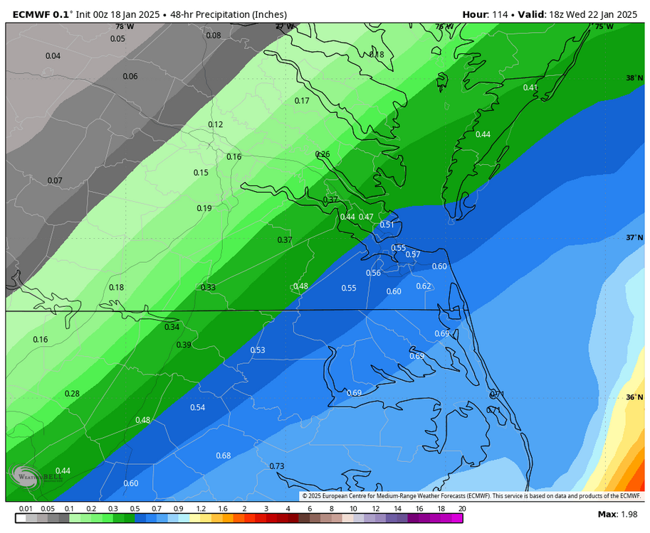
RIC Airport replied to RIC Airport's topic in Mid Atlantic
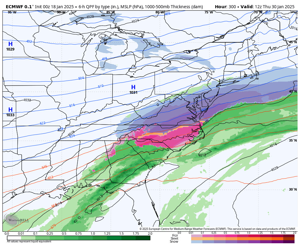
Latest from WPC on the mid week storm threat.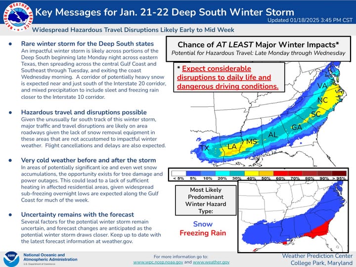
-
Richmond Metro/Hampton Roads Area Discussion
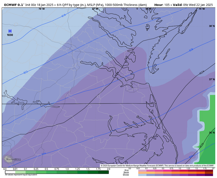
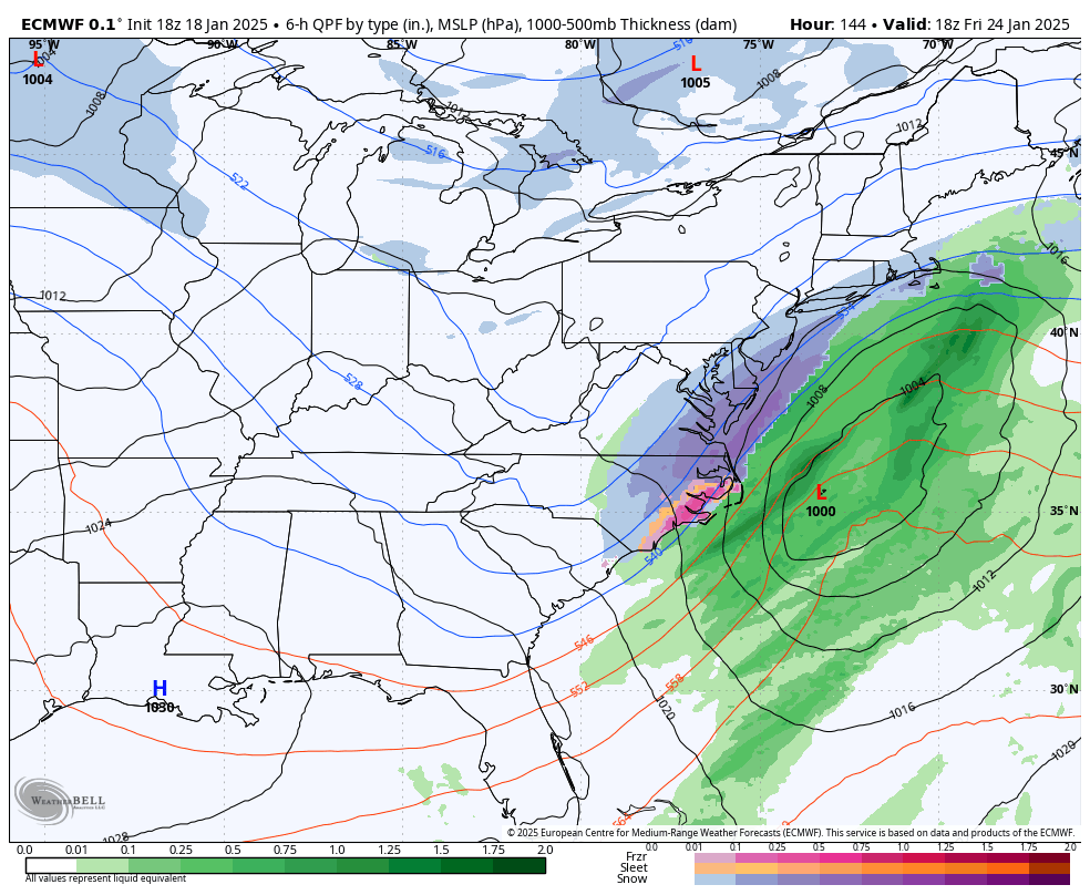
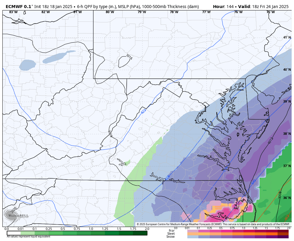
RIC Airport replied to RIC Airport's topic in Mid Atlantic
EPS for the midweek event.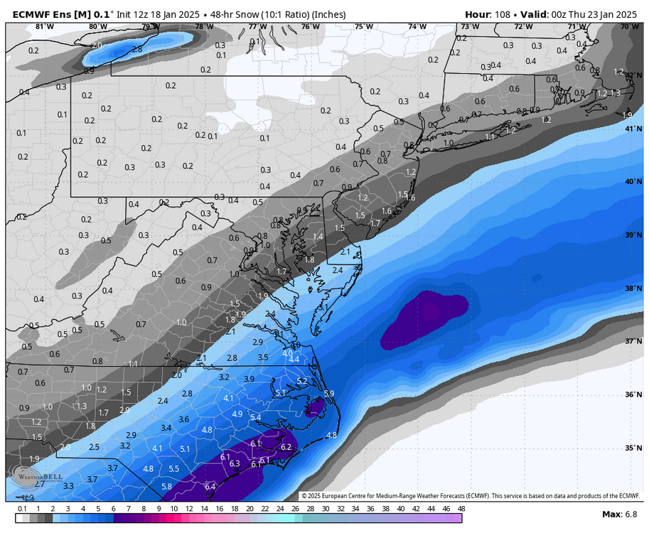
-
Richmond Metro/Hampton Roads Area Discussion
RIC Airport replied to RIC Airport's topic in Mid Atlantic
DCA or ORF are the only places that seems to get good storms. Saw this in the 2021-22 winter. -
Richmond Metro/Hampton Roads Area Discussion
RIC Airport replied to RIC Airport's topic in Mid Atlantic
I might have to consider taking a trip as well if trends keep up. -
Richmond Metro/Hampton Roads Area Discussion
RIC Airport replied to RIC Airport's topic in Mid Atlantic
I'll be rooting for you, @Stormpc. You're the hardest in our region to get any snow. But, the way things are looking the 1/23/2003 storm seems to be a good analog. Cape Hatteras received 12" from that. Time will tell, still time for shifting of the models.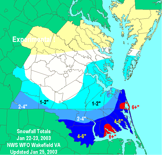
-
Richmond Metro/Hampton Roads Area Discussion
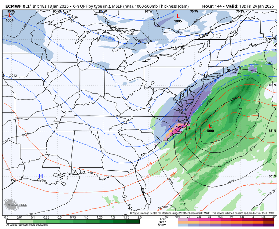
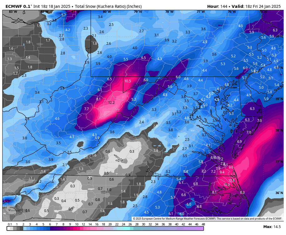
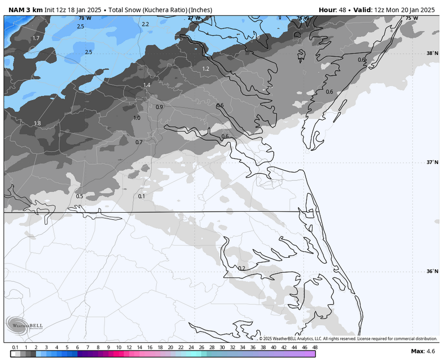
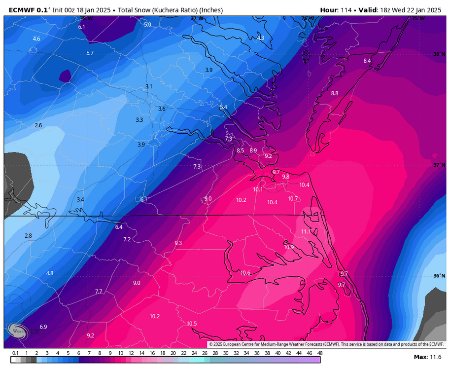
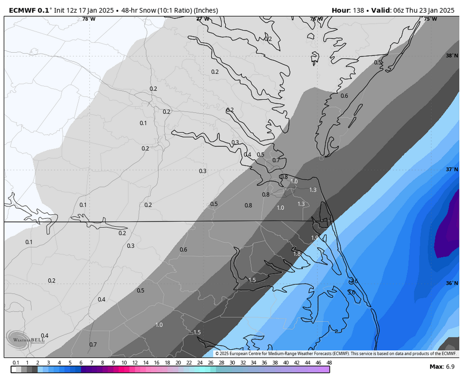
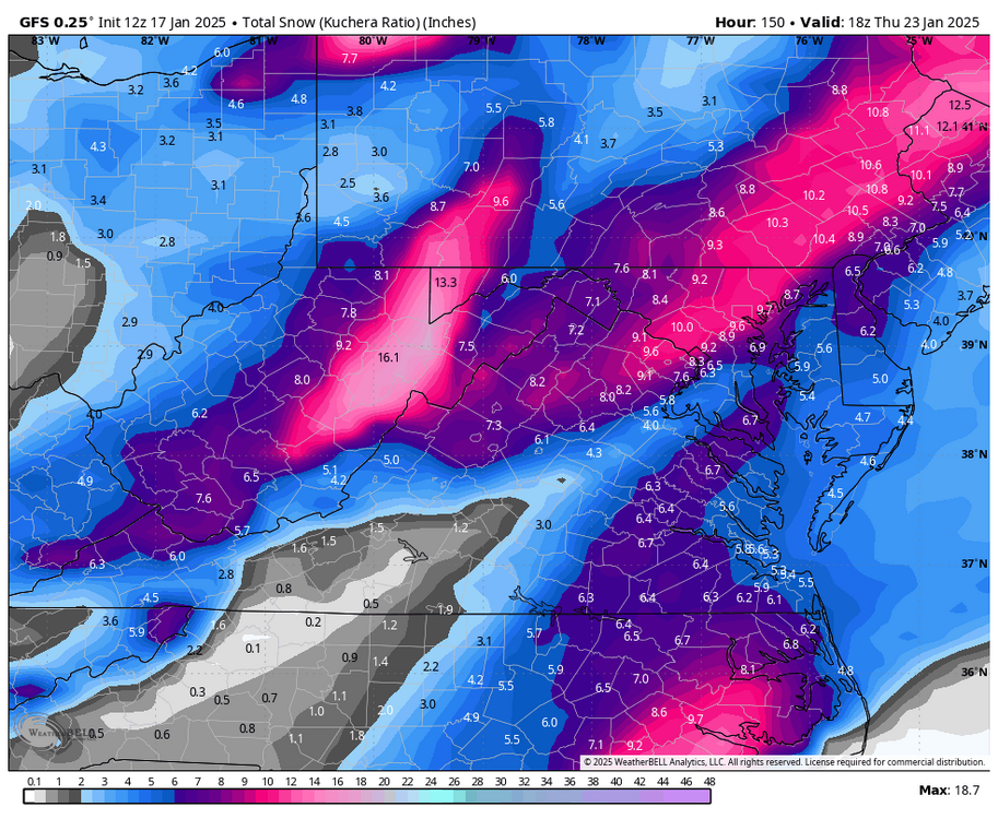
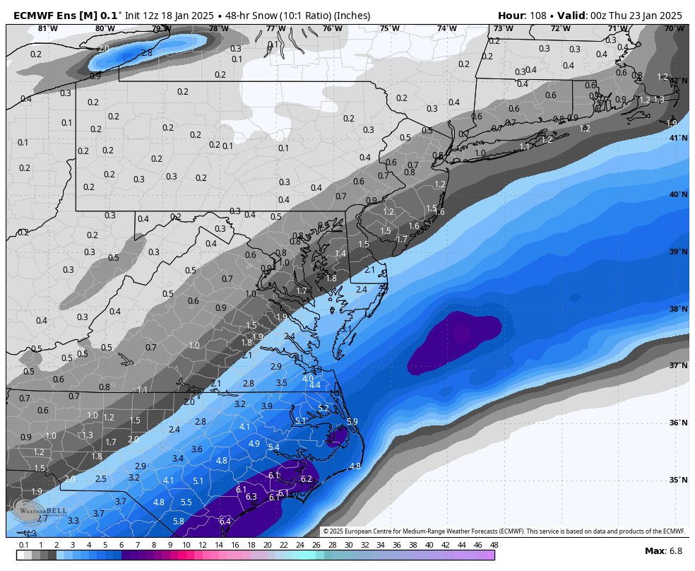
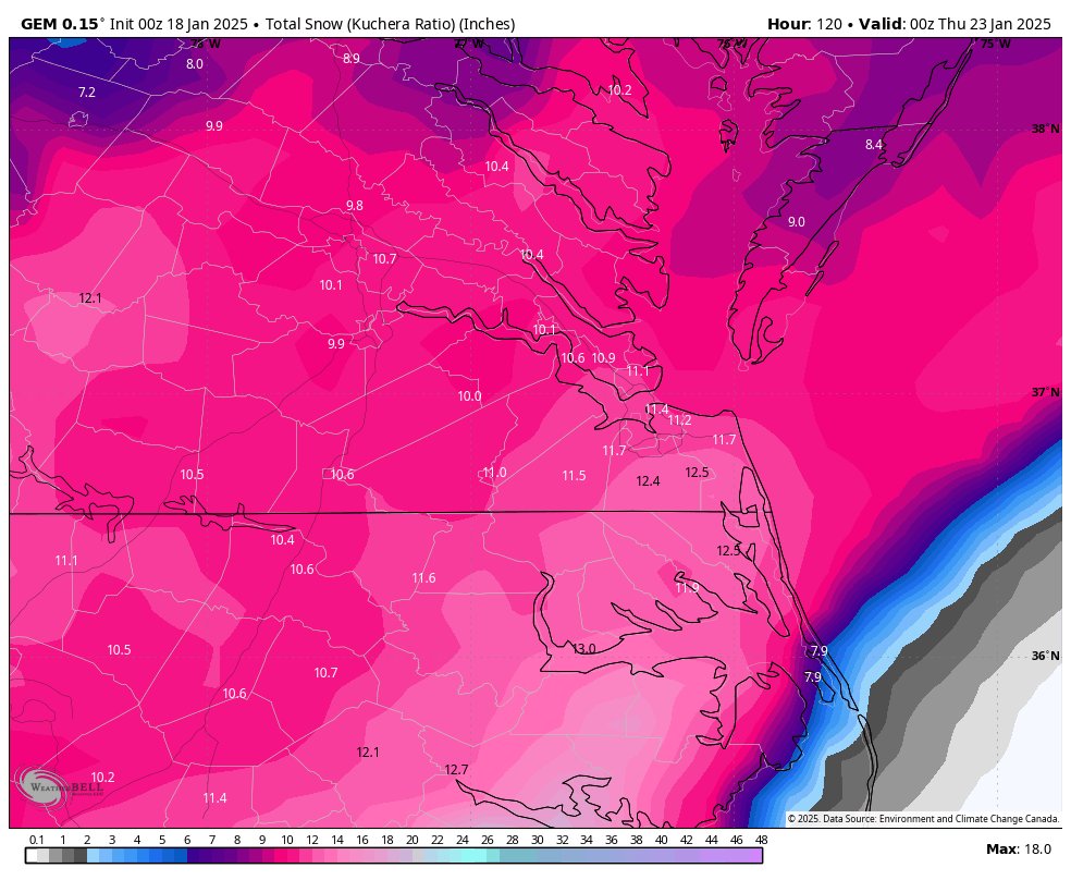
RIC Airport replied to RIC Airport's topic in Mid Atlantic
Here is the kuchera maps, covers both events.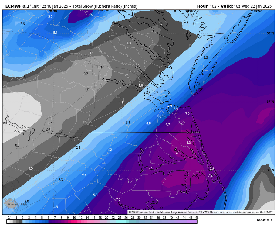
-
Richmond Metro/Hampton Roads Area Discussion
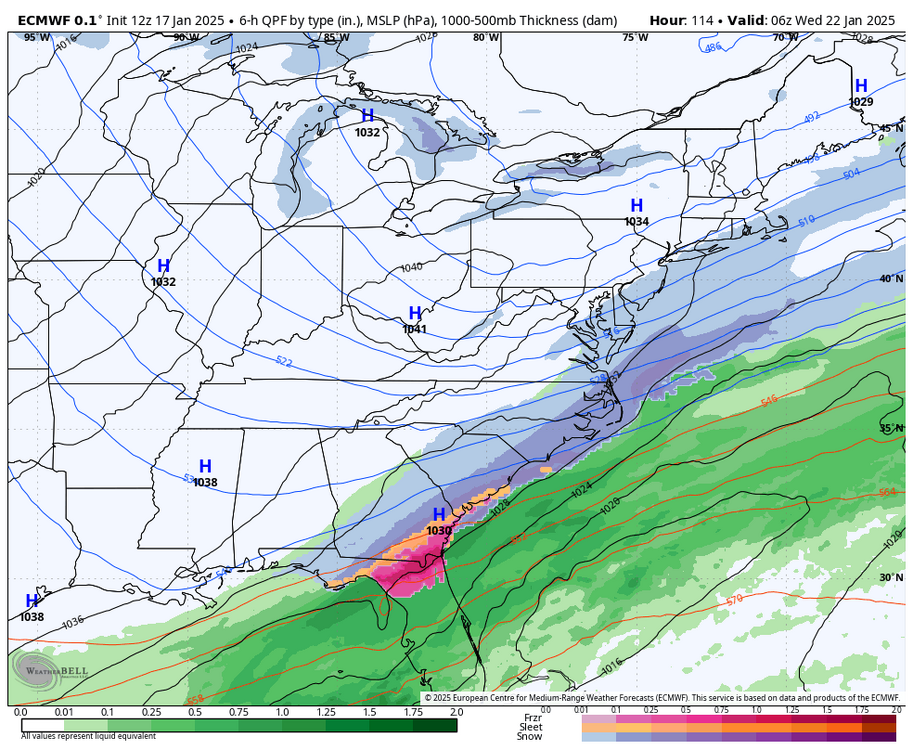
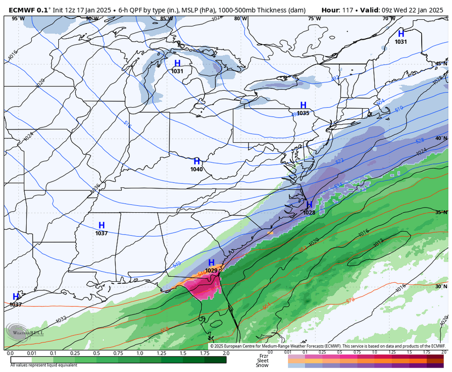
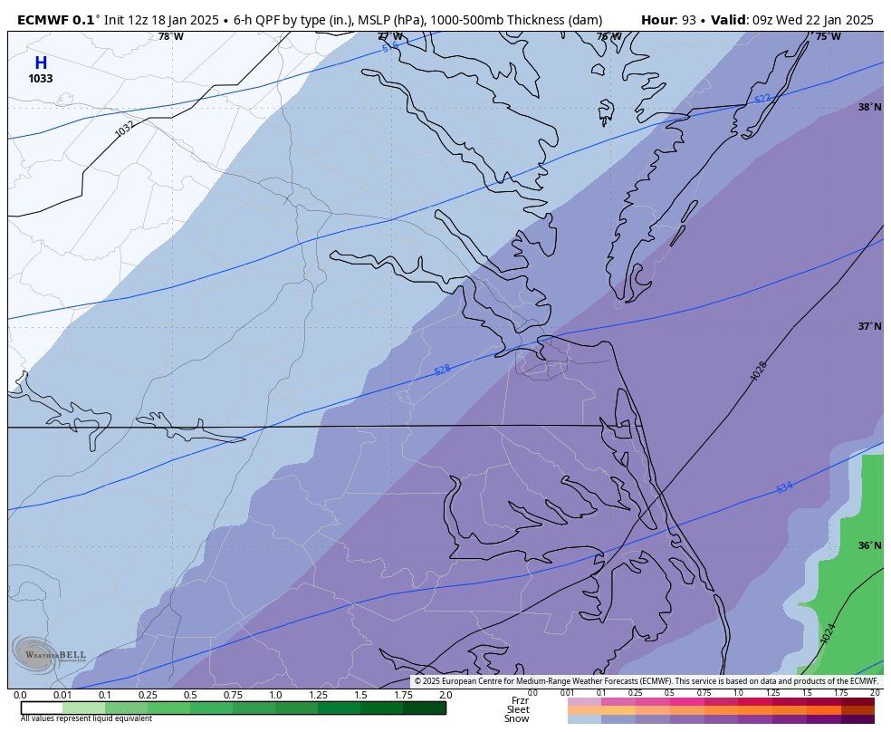
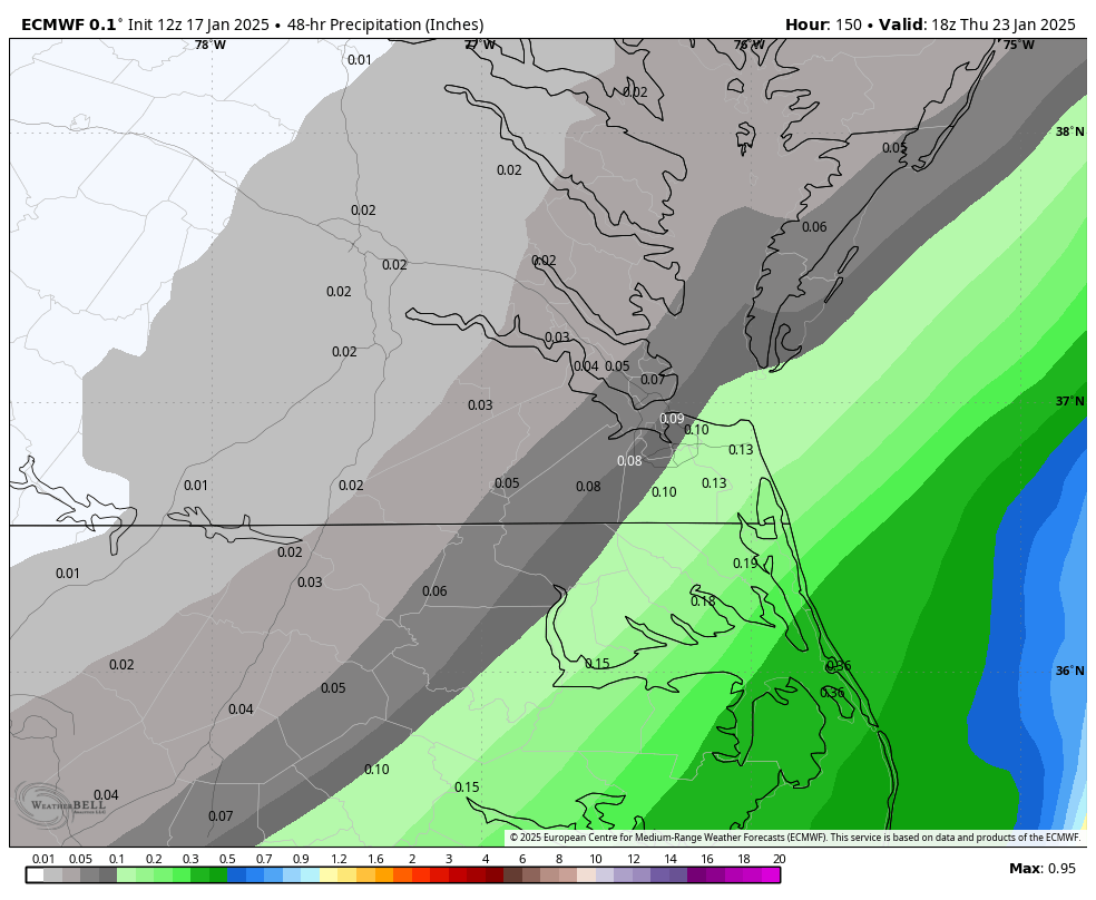
RIC Airport replied to RIC Airport's topic in Mid Atlantic
12z Euro is not as good as the 6z or 00z run, but still gets snow up into our area, especially Hampton Roads.
-
Richmond Metro/Hampton Roads Area Discussion
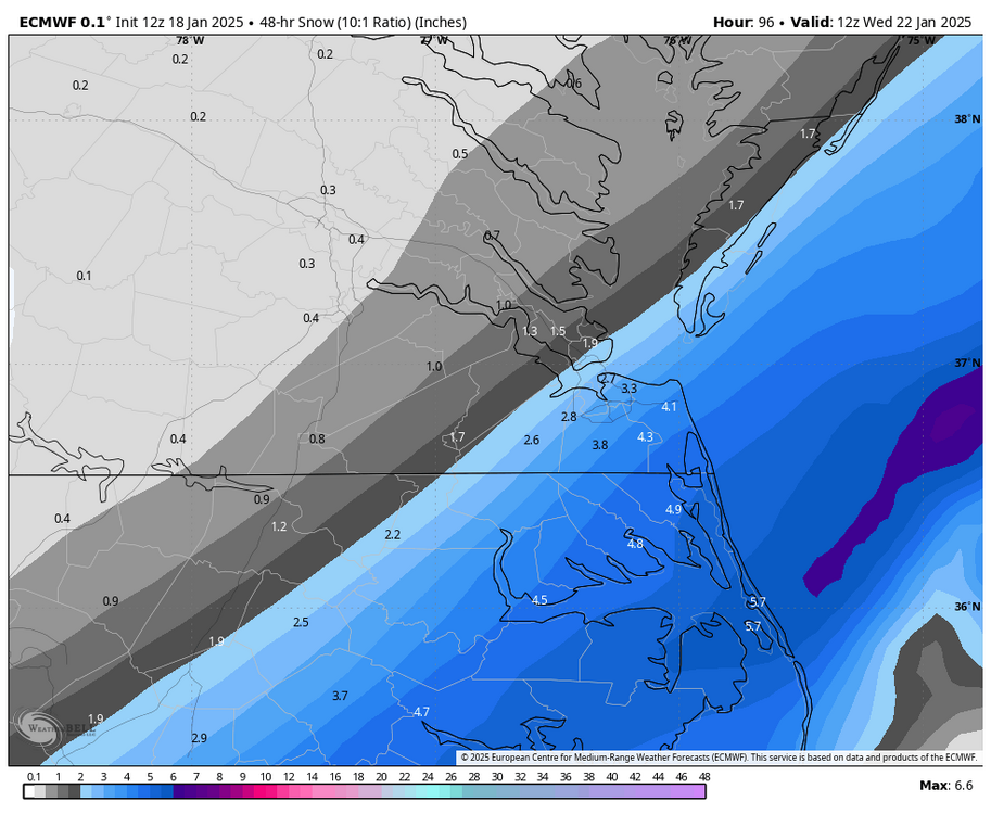
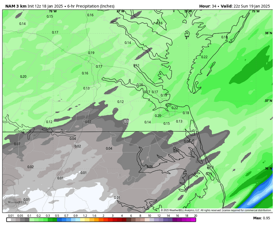
RIC Airport replied to RIC Airport's topic in Mid Atlantic
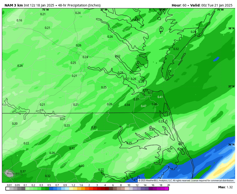
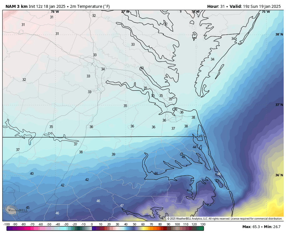
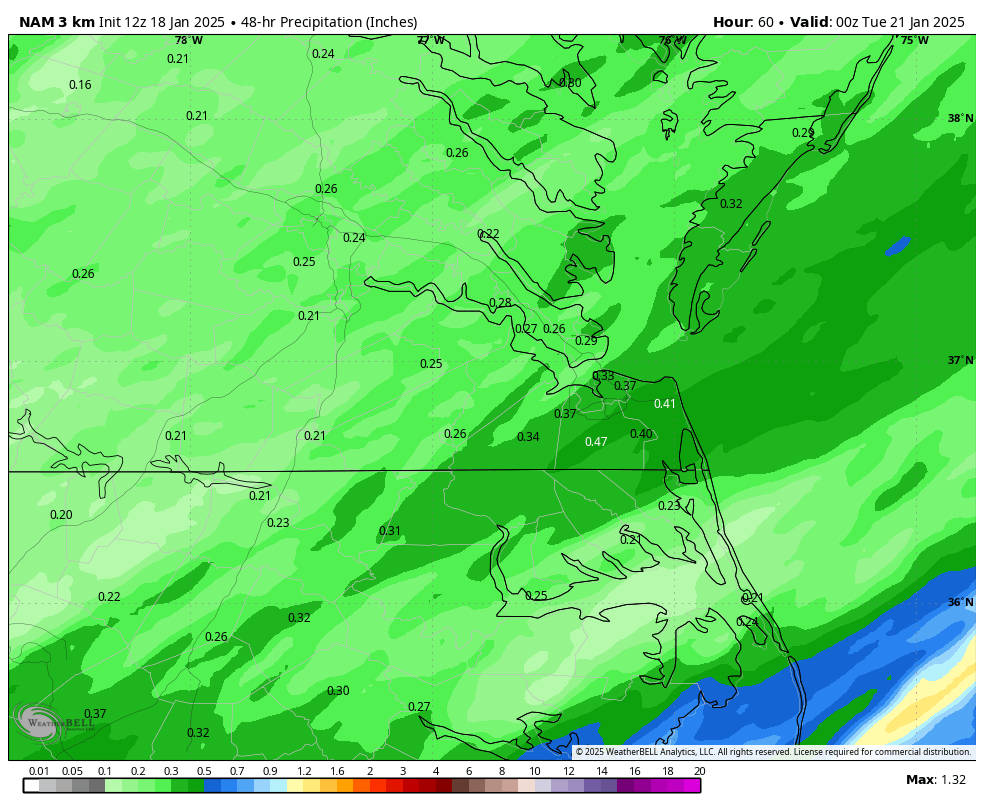
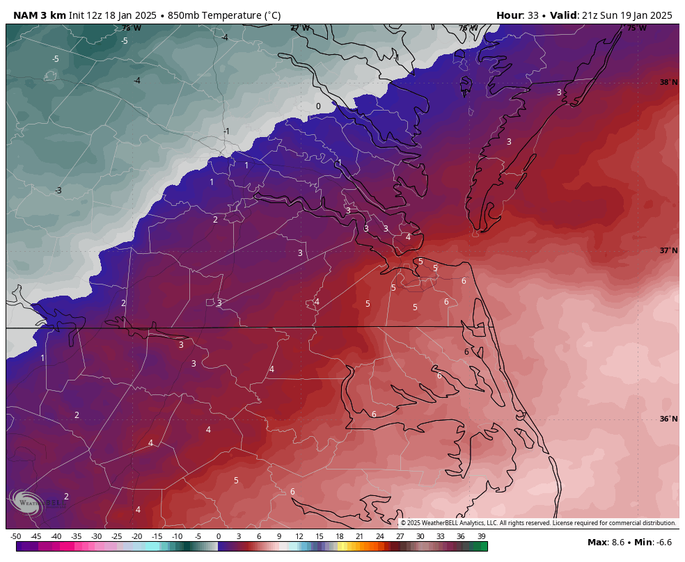
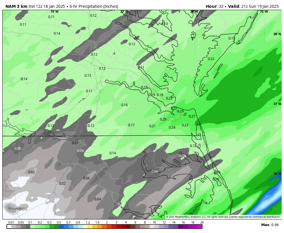
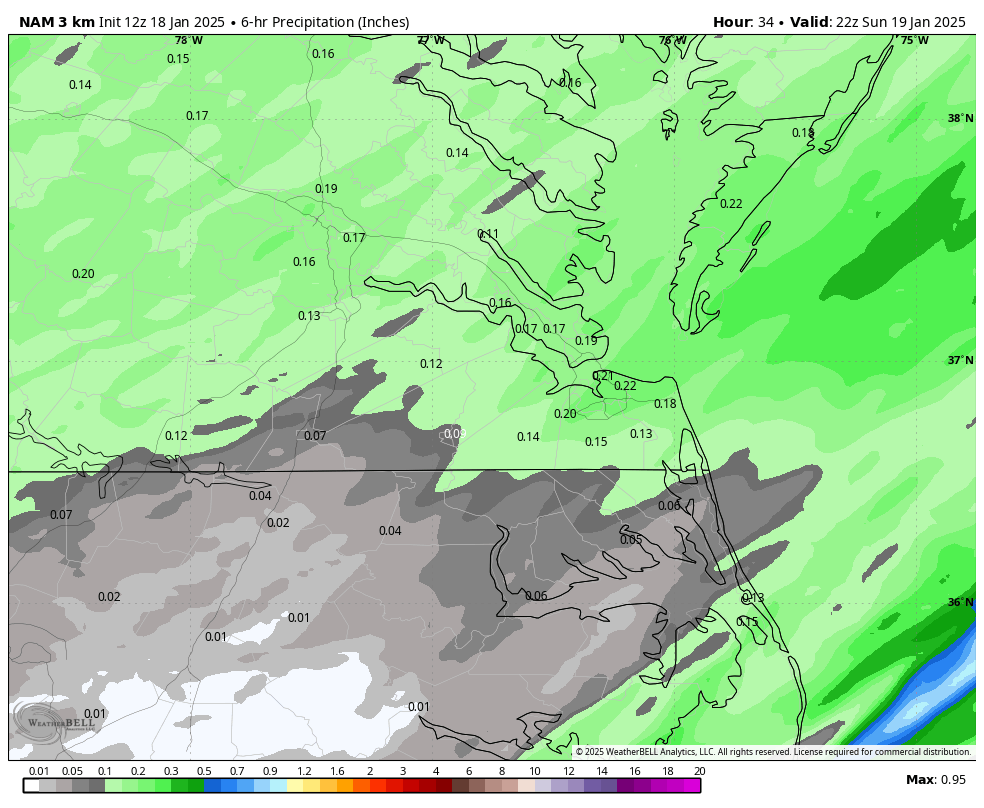
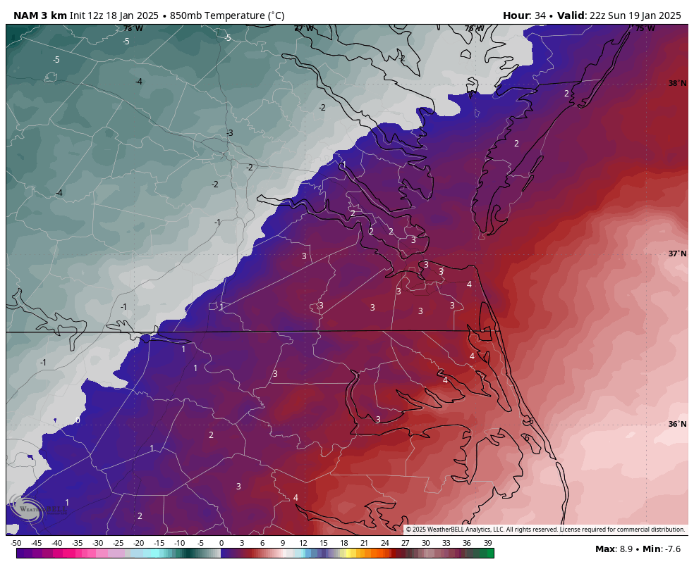
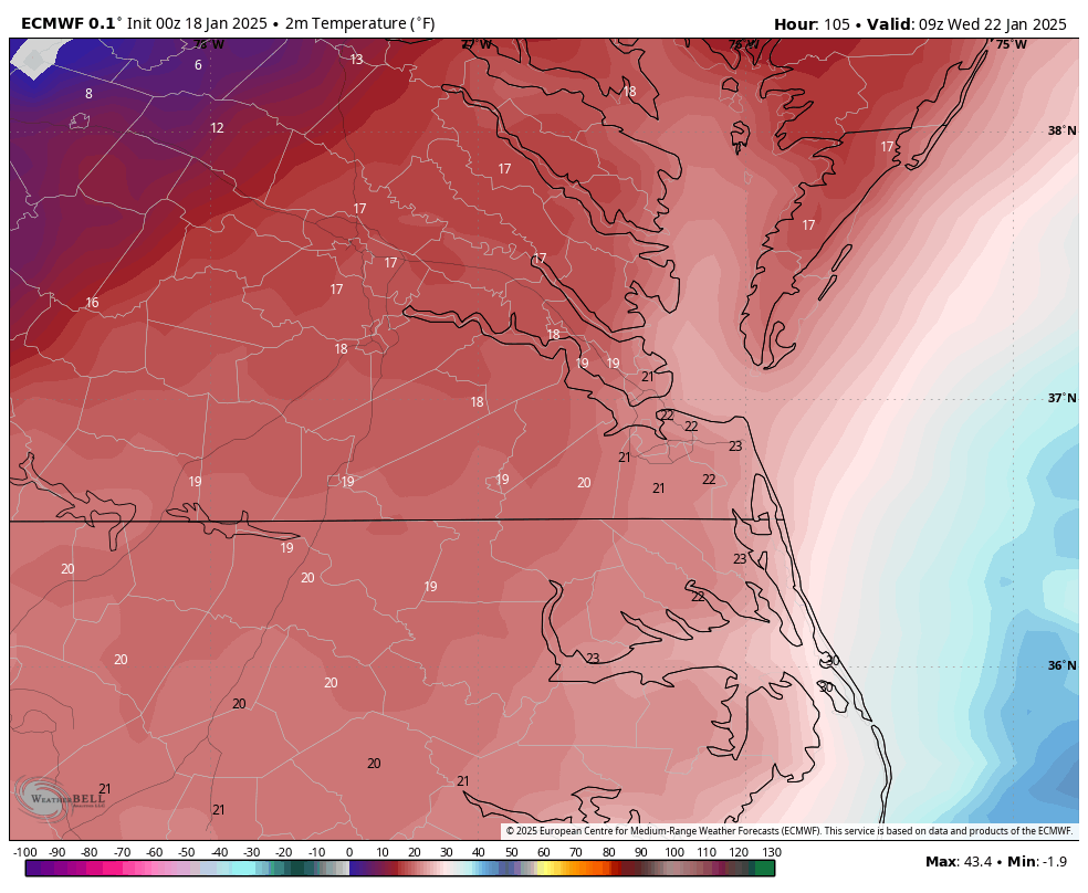
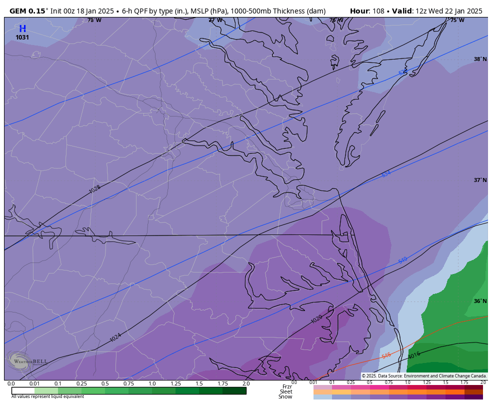
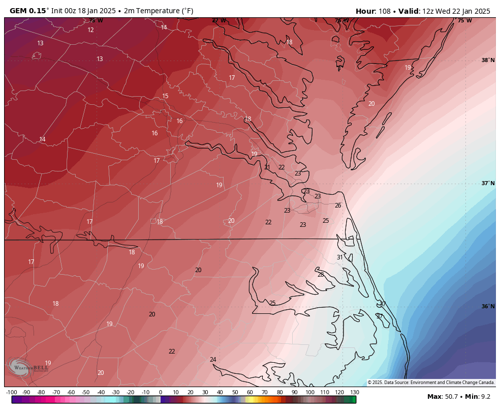
Also, here is the 3K NAM. Getting an inch around Richmond will be challenging, although some areas just north and west of the city have the best chance. I pointed out in a post a couple of days ago that the problem is that we only have a 2-3 hour window with good enough rates and a cold enough column for accumulations. 3K NAM has about a 0.24"-0.26" of QPF across metro Richmond for Sunday's event. We waste HALF of our QPF before temperatures at the surface and at 850mb drop below freezing. 3K NAM doesn't have surface temperature reaching freezing until 3-5 pm (north to south) in the Richmond metro area. If you look at the map below, OFP, FCI, and RIC are still above freezing at 2 pm. More importantly, even as late as 4 pm, there is still warmer air at 850mb bisecting the metro area, so even if it's cold at the surface, any precip will be mixing and not accumulating at that time. 3K NAM does not cool the column entirely until 5 pm; by that time, 0.12" - 0.17" of the 0.24-0.26" total QPF has already fallen. So, MOST places would probably expect a dusting to half an inch at best. Obviously, if you live north of Richmond in places like Hanover, where it gets colder faster, you can get more.


-
Richmond Metro/Hampton Roads Area Discussion
RIC Airport replied to RIC Airport's topic in Mid Atlantic
I hear what you're saying and know you're seeking affirmation. I'm just providing information. I would not forecast 2-4" for Richmond Tuesday night until there is better agreement with the guidance. Many variables remain in play to say that confidently. The Canadian, although we do use it as a tool, it doesn't have a good track record over the Euro and GFS for snowstorms in our area. -
Richmond Metro/Hampton Roads Area Discussion
RIC Airport replied to RIC Airport's topic in Mid Atlantic
I'd like to see the GFS and Euro come into better agreement. The 00z Euro was a big step in the right direction, especially for Hampton Roads and NE NC. The 6z run was a hair east of the 00z run. If we are relying on the Canadian or UkMet, we are in trouble. I just saw that the 12z Canadian backed off significantly. -
Richmond Metro/Hampton Roads Area Discussion
RIC Airport replied to RIC Airport's topic in Mid Atlantic
More to come. Good night!
-
Richmond Metro/Hampton Roads Area Discussion
RIC Airport replied to RIC Airport's topic in Mid Atlantic
Just wanted to post the maps, had a long day...literally falling asleep now. I'll take a deeper look late tomorrow morning. Looks like placement of the low was farther north and west from 18z and 12z. Hope later runs remain favorable would be awesome to get snow in the teens. -
Richmond Metro/Hampton Roads Area Discussion
RIC Airport replied to RIC Airport's topic in Mid Atlantic
-
Richmond Metro/Hampton Roads Area Discussion
RIC Airport replied to RIC Airport's topic in Mid Atlantic

-
Richmond Metro/Hampton Roads Area Discussion
RIC Airport replied to RIC Airport's topic in Mid Atlantic
One can dream. Frigid, too! But, the March 1980 blizzard also had mid-upper teens in Richmond and only around 20°F at ORF during that storm.


-
Richmond Metro/Hampton Roads Area Discussion
RIC Airport replied to RIC Airport's topic in Mid Atlantic
Great! I didn't click down there, haha. But, a chance of snow with temps in the low teens is not something you see often around here. -
Richmond Metro/Hampton Roads Area Discussion
RIC Airport replied to RIC Airport's topic in Mid Atlantic
Wakefield has added 40% pops for Tuesday night over Hampton Roads and 30% pops for the rest of the CWA including Richmond. -
Richmond Metro/Hampton Roads Area Discussion
RIC Airport replied to RIC Airport's topic in Mid Atlantic
There were hints of another threat next Friday to keep things interesting. -
Richmond Metro/Hampton Roads Area Discussion
RIC Airport replied to RIC Airport's topic in Mid Atlantic
12z Euro was an improvement fwiw..thumb.png.ec102211cf1786b06ebea6941714af7c.png)

-
Richmond Metro/Hampton Roads Area Discussion
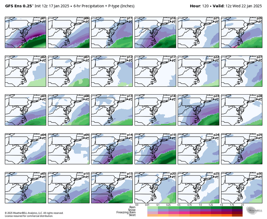
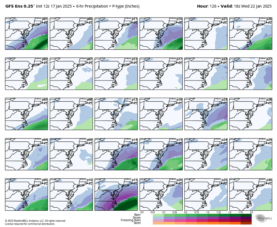
RIC Airport replied to RIC Airport's topic in Mid Atlantic
12z GEFS for mid week storm.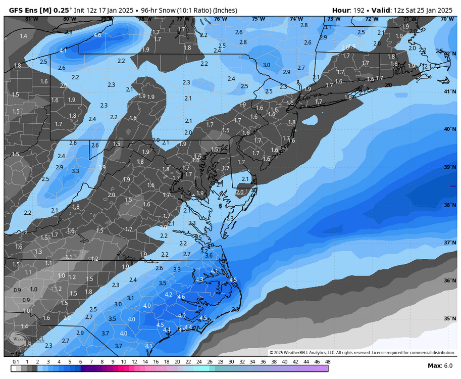

-
Richmond Metro/Hampton Roads Area Discussion
RIC Airport replied to RIC Airport's topic in Mid Atlantic
If so, hopefully we can expand the snow farther west. -
Richmond Metro/Hampton Roads Area Discussion
RIC Airport replied to RIC Airport's topic in Mid Atlantic
1/29/2014 could be a close analog.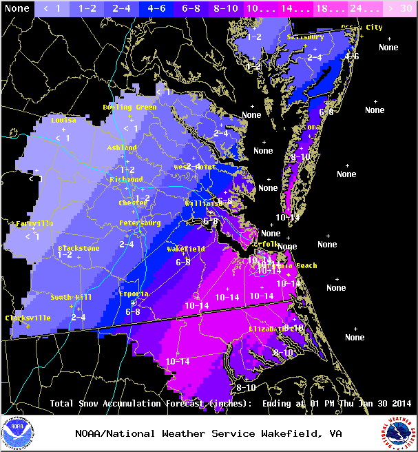
-
Richmond Metro/Hampton Roads Area Discussion
RIC Airport replied to RIC Airport's topic in Mid Atlantic
Not at home at the moment and won't be for most of the afternoon. Got a lot going on today so can't be attentive to the runs, but I'll try to check things when I can from my phone. -
Richmond Metro/Hampton Roads Area Discussion
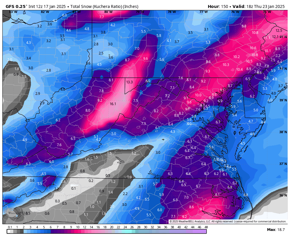
RIC Airport replied to RIC Airport's topic in Mid Atlantic
12z GFS trending in the right direction for mid week.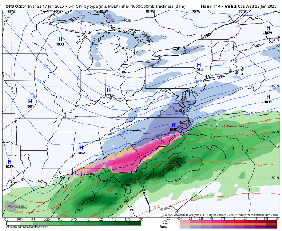
.thumb.png.148765865cb55776d42a1d4a85ed1022.png)


.png.afc15a4145638d8fd89293696ae7d7ad.png)


.png.4147df9053a5725979edaabae0d8e769.png)