RIC Airport
Members-
Posts
2,586 -
Joined
-
Last visited
About RIC Airport

- Birthday 06/02/1981
Profile Information
-
Four Letter Airport Code For Weather Obs (Such as KDCA)
KRIC
-
Gender
Male
-
Location:
Richmond, VA
-
Interests
Snowstorms, Hurricanes, Severe Thunderstorms, Arctic Outbreaks, Heat Waves
-
Richmond Metro/Hampton Roads Area Discussion
RIC Airport replied to RIC Airport's topic in Mid Atlantic
The late February sun angle, unfortunately, is powerful. There was less snow back in January under similar conditions that barely melted during the day. -
Richmond Metro/Hampton Roads Area Discussion
RIC Airport replied to RIC Airport's topic in Mid Atlantic
Congrats to all! This was a very fun event! Tracking snow is exhausting. I crashed last night without the stress. -
Richmond Metro/Hampton Roads Area Discussion
RIC Airport replied to RIC Airport's topic in Mid Atlantic
https://www.weather.gov/wrh/Climate?wfo=akq That's the link to Wakefield's climate page. You'll have to dig deeper using the NOW data for some of the info you want. But, if you click on Local Climate, they have charts for the top 10 lists for temp, precip, and snowfall for Richmond and Norfolk. Below are the largest snowstorms (4"+) in Richmond and Norfolk since 2000. I counted 10 snowstorms 6" or more in Richmond and seven snowstorms 6" or more in Norfolk. Richmond is leading the pack, but that does not mean "parts" of Hampton Roads have not had more snow than Richmond. As I mentioned in this post yesterday, Norfolk has been snowier relative to the average compared to Richmond. Richmond Snowstorms 4" or more (since 2000) 4.0" February 19, 2025 11.5" December 9, 2018 7.1" January 7, 2017 11.4" January 22-23, 2016 5.0" February 26, 2015 7.2" February 16-17, 2015 5.8" February 12-13, 2014 6.6" February 5-6, 2010 10.0" January 30-31, 2010 7.4" December 18-19, 2009 6.3" March 1-2, 2009 7.7" January 2-3, 2002 11.0" January 25, 2000 Norfolk Snowstorms 4" or more (since 2000) 11.0" February 19-20, 2025 4.0" January 28-29, 2022 6.8" January 21-22, 2022 10.3" January 3-4, 2018 5.3” January 7, 2017 5.5” February 26, 2015 8.5” January 28-29, 2014 14.2” December 25-26, 2010 6.5” January 30-31, 2010 5.0” December 26, 2004 7.7” January 2-3, 2002 4.7” January 25, 2000 -
-
Richmond Metro/Hampton Roads Area Discussion
RIC Airport replied to RIC Airport's topic in Mid Atlantic
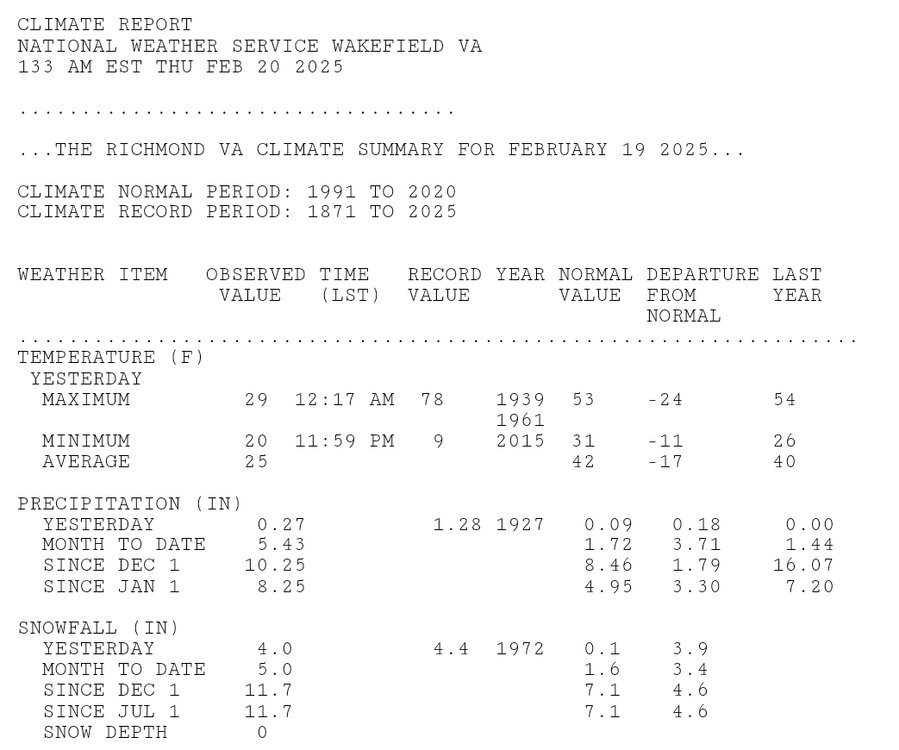
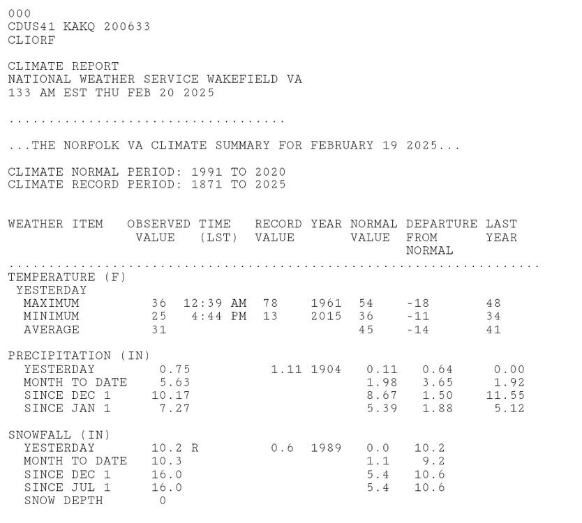
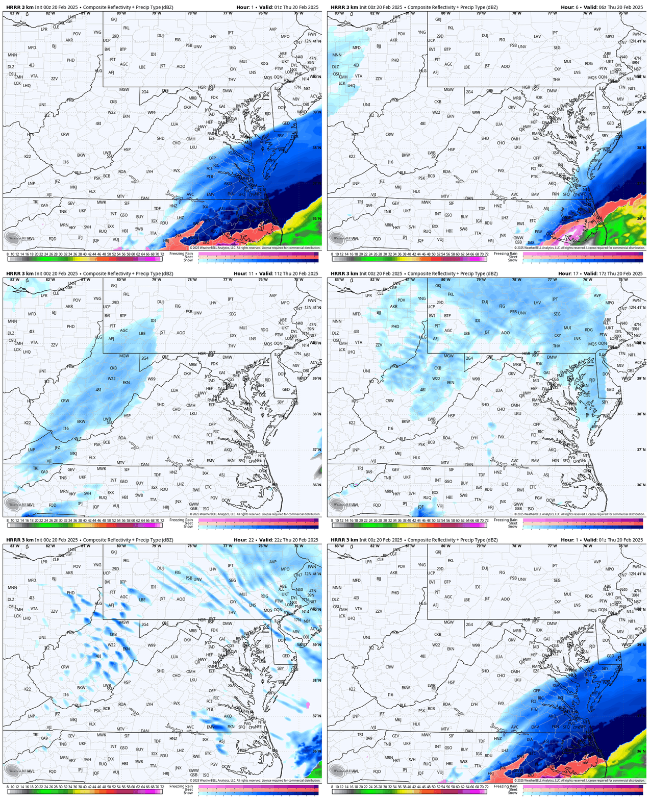
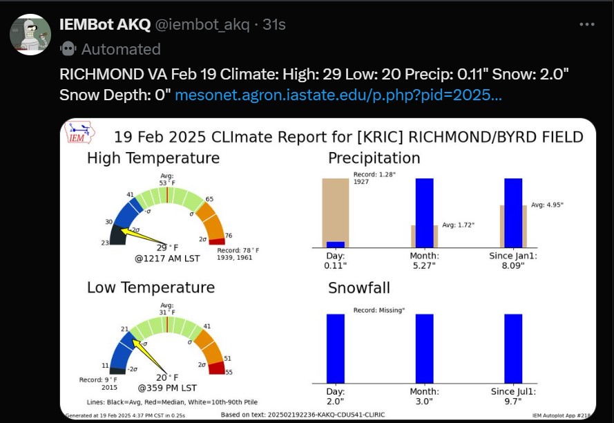
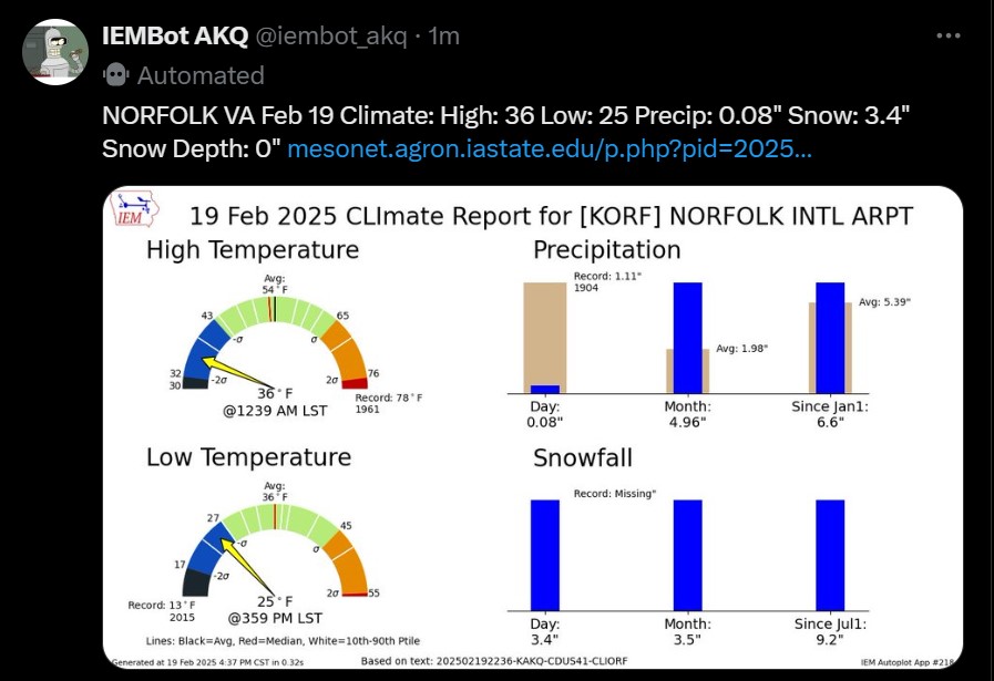
DT exaggerates so would need to verify the exact numbers. ORF may not get every storm but they've gotten more big ones than RIC. They also have a longer period of record so when you include February 2025, this is now the 8th time they've recorded a top 10 snowiest month this century, whereas RIC has only had 4 such occurrences. Here are the CLI reports for yesterday. ORF should add to theirs slightly since it was still snowing after midnight. Both stations also have a shot depending on the performance of the ULL later this morning, but both HRRR and 3K NAM seem to have it struggling once it gets east of the mountains. -
Richmond Metro/Hampton Roads Area Discussion
RIC Airport replied to RIC Airport's topic in Mid Atlantic
-
Richmond Metro/Hampton Roads Area Discussion
RIC Airport replied to RIC Airport's topic in Mid Atlantic
If you send that in to NWS, it'll likely be thrown out as erroneous and not included in any official report. I'm not seeing anything close to 9" anywhere around Chester. But, I agree, the back end saved the day. -
Richmond Metro/Hampton Roads Area Discussion
RIC Airport replied to RIC Airport's topic in Mid Atlantic
-
Richmond Metro/Hampton Roads Area Discussion
RIC Airport replied to RIC Airport's topic in Mid Atlantic
-
Richmond Metro/Hampton Roads Area Discussion
RIC Airport replied to RIC Airport's topic in Mid Atlantic
-
Richmond Metro/Hampton Roads Area Discussion
RIC Airport replied to RIC Airport's topic in Mid Atlantic
-
Richmond Metro/Hampton Roads Area Discussion
RIC Airport replied to RIC Airport's topic in Mid Atlantic
-
Richmond Metro/Hampton Roads Area Discussion
RIC Airport replied to RIC Airport's topic in Mid Atlantic
-
Richmond Metro/Hampton Roads Area Discussion
RIC Airport replied to RIC Airport's topic in Mid Atlantic
That's right, along with the others. But when it shifted SE, it was consistent with this idea. Way too many placed too much faith in the western outliers and have been adjusting east ever since. Remember when Matt Dinardo went 9-12" for Richmond 24 hours ago? It was also bad enough that within hours of him doing a live stream about his changes, with hundreds of views, the NWS upgraded the RIC area to warning for only 3-6". AKQ did much better than the Richmond TV stations. Oh, and he was the main one a few days ago telling people to listen to him and not the "social mediaologists" . -
Richmond Metro/Hampton Roads Area Discussion
RIC Airport replied to RIC Airport's topic in Mid Atlantic
Hard to against the King.


