
ers-wxman1
-
Posts
2,525 -
Joined
-
Last visited
Content Type
Profiles
Blogs
Forums
American Weather
Media Demo
Store
Gallery
Everything posted by ers-wxman1
-
Take this over to banter and stop ruining things for those of us that actually analyze the situation and make productive posts.
- 900 replies
-
- 12
-

-

-
So all of our analysis goes to pot? That’s the way events roll. You don’t shut off a thread because an event doesn’t work out.
-
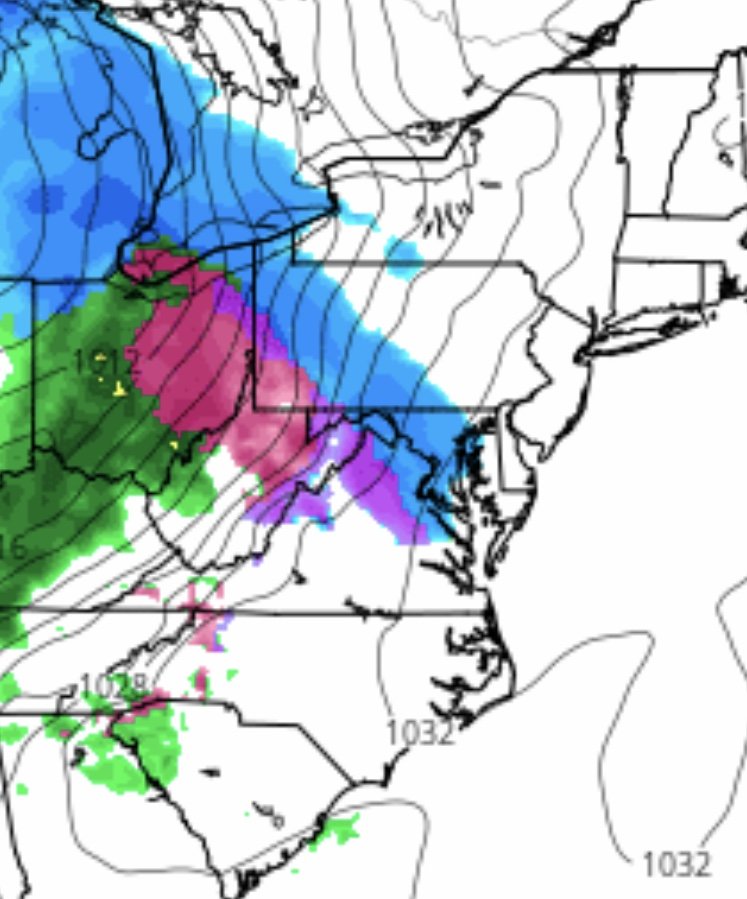
12z ICON holds serve, tad colder with snow transitioning to freezing rain. CAD holds on until 03z Sunday. Significant icing.
-
Different look to the NAM this morning. Less WAA, more frontal passage. Right in tune with the way this winter has been going.
-
Icing events are among the most difficult patterns to predict in the MA. Low 30s won’t cut it for optimal accretion. Ideal is less than 30F and rates come into play. Strength of the WAA and resilience of the CAD. I’ve never seen any model handle it perfectly in this area, not even the colder solutions.
-
cant rely on the globals to analyze a CAD setup like this.
-
Not much to go on with the ICON being such a new model. GFS is likely too warm. Given the strength and depth of that high plus source region, likely to see temps on the colder side of guidance and hanging in longer. Temps not an issue.
-
00z ICON continues to be a significant icing event for Saturday. At 12z Saturday the freezing line is wedged all the way down into NC. Doesn’t get above freezing in DC until 03z Sunday.
-
3k NAM shouldn’t even be looked at in this range. Precip isn’t even close to our area.
-
12k is ok, bit wet, but more so the pattern change with more vorticity leading ahead of the main system out west and a pronounced cold wedge.
-
Unreal. We’ve been saying it all along about the icon on TT. Posts like that just muddle the forum.
-
That will be all ice!
-
18z ICON slowed the precip down a bit, However, keeps a solid CAD feature in place. Signal is there for a decent icing event.
-
What are you looking at? The model doesn’t show sleet/freezing rain. I’m seeing a good CAD all the way past 21z.
-
Should never count things out until you see the whites of its eyes for situations like this. Around here all it takes is a glaze on roads, trees, and power lines in the 20s to have significant impacts.
-
This is why the globals should be looked at it with a grain of salt in the medium range with CAD situations. I like to use the medium range globals to give a general pattern depiction then go on what we know to happen in these situations. Even the mesoscale models struggle.
-
18z NAM could certainly give those from Loudoun to central MD a couple inches before the transition.
-
18z 12k NAM holds serve, bit more energized than 12z. Moderate snow to start then to mix, break then freezing rain. Not bad considering where we were 24 hours ago.
-
12z Icon has an impressive icing event. TT maps do not show sleet/freezing rain but 2m temp contours show it not getting above freezing until after 00z Sunday with decent QPF. Much of the area west of the fall line stays in the 20s into the afternoon.
-
And when the CAD wedge goes through Atlanta! Solid!
-
Start a new thread. We are 74 pages in on this one.
-
Guidance finally coming around to reality for this event. 1040 high in the right place with insitu damming will yield a more entrenched airmass. Models, particularly the globals are almost always underdone and or too aggressive on eroding this feature out.
-
CAD is almost always underdone in the guidance. As strong of a high that is being sampled here, would expect a strong footprint, tougher to erode.
-
1”/hr rates as progged by the mesoscale models will quickly overcome the BL issues, even some main roads. It won’t take much this time of the year.