showmethesnow
-
Posts
7,250 -
Joined
-
Last visited
Content Type
Profiles
Blogs
Forums
American Weather
Media Demo
Store
Gallery
Everything posted by showmethesnow
-
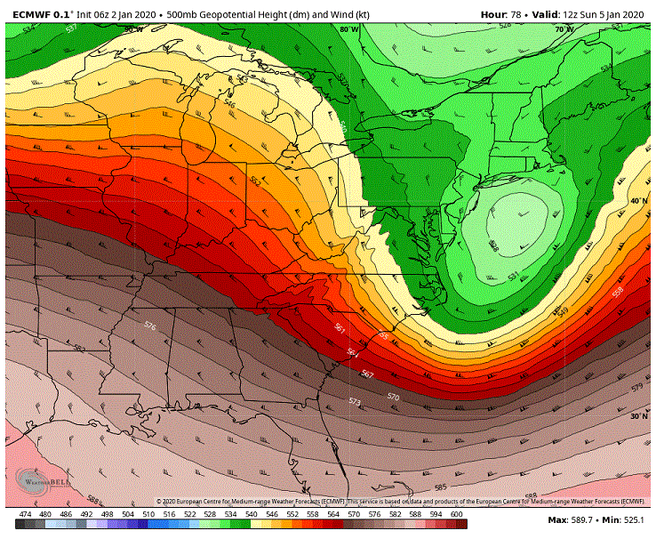
Actually are seeing the beginnings of a capture at hour 78. Still just a touch too far off the coast for our needs through the DC/Balt region. But.... See a capture at this point and we are good to go. Mind you this frame is only separated by 3 hours from the above. And as we continue to see the coastal low lag farther and farther behind as well as shifting southward this scenario is very much in play with the current trends we are seeing on the Euro. Will be interesting to see what the ensembles spit out on the snowfall maps.
-
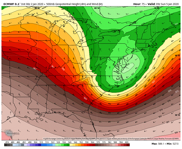
LOL. I keep forgetting we now have a 06Z Euro. Several things I am seeing here. Seeing a slighter deeper drop of the trough. The trough is coming in quicker. Seeing better height builds in front of it. And the trough axis is rotating slightly quicker as to where we are almost on the verge of seeing a neg tilt as it runs through our region. Also the low continues to lag further and further behind. Really starting to like the look the Euro is throwing us. It is getting very close to seeing a capture of the low somewhere off the upper Delmarva/S Jersey Shores.
-
Not going to write a novel on it but our potential day 6 storm is still very much in play. Saw an uptick on the snow means from both the GEFS and the EPS for those that follow that.
-
06Z GFS continues it's move towards a Euro type solution for this weekend.
-
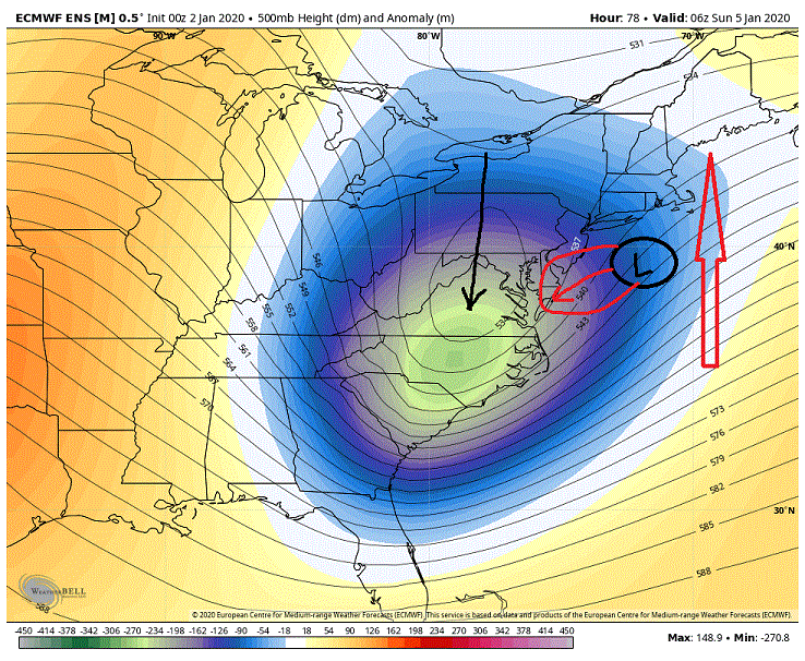
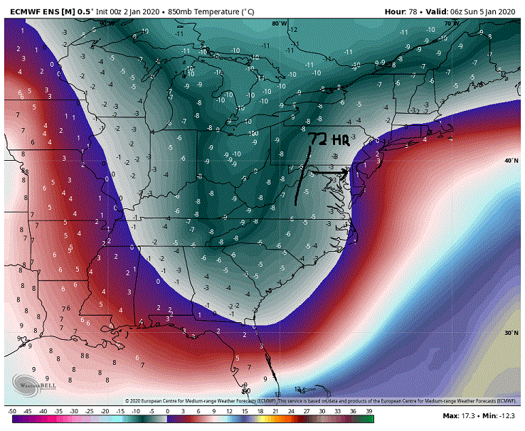
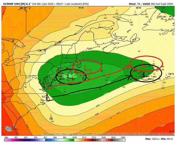
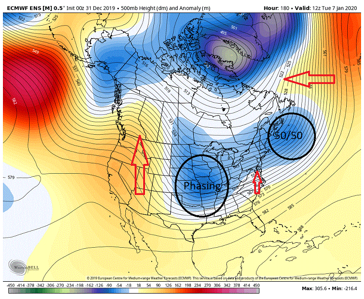
Euro suite officially has my interest for this weekend. What we have seen generally run over run the last few days is that the trough pulling through the East is now taking on a nuetralish tilt compared to the positive tilt seen just a couple of days ago. We are also seeing better height builds/ridging in front of the trough which is helping to turn this trough. In response to this more favorable setup at 500's the low is responding as it lags further and further behind waiting for the 500's to catch up to it. Now this is hour 78 just after the 850's have cleared the bay. Note that the mean low is off the Jersey shores at this point. The look at this time is so close to potentially putting appreciable snows on the Eastern Shore and maybe some minor accumulations west of the Bay. But what I will point out is that a heavy half of the ensemble members place the low to the W/SW of the mean low which would up the possibilities. Now one thing that we will be fighting initially are temps at the lower levels to the surface. As you can see below the 850's have quickly cleared our region (at 72 hours it resided in western MD) but what we had leading into it were surface temps in the upper 40's/lower 50s. So what we will need to see are decent rates to overcome this lower level warmth otherwise we are waiting on the cold air to bleed in which will be too late for the cause. There is something else I want to point out. A key player in this potential will be a front running low as it sets up the baroclinic zone for the trailing low that will intensify off the coast. What we have seen over the last day or two of runs is that the front running low has progressed southward as to where it is initiating off of roughly OV vs. off the Delmarva. As you can see the front running low track is now farther south then previous runs and has subsequently dragged the baroclinic zone southward as well. This does two things. First it is placing the trailing intensifying low farther south in a more favorable local for our region. What it is also doing is reducing the distance between the favorable 500's (closed low) trailing being the intensifying coastal so now we are seeing the low responding by lagging further behind. These are good things to see. Now the GFS/GEFS is not on board at this time as the 500's just are not there. But we have seen a progression on it's part the last few runs to move towards a Euro type solution so do not be surprised if we start seeing favorable outcomes in the next day or so of runs. As I said, I am now officially interested. Wouldn't take much in the way of adjustments to actually see a good outcome potentially for west of the Bay and in particular on the Eastern Shore.
-
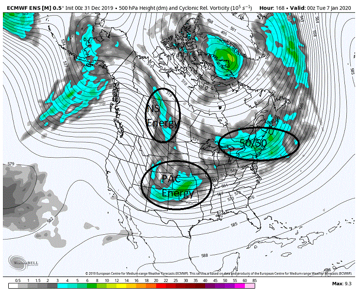
Euro/EPS are trying their hardest to make this weekend somewhat interesting especially towards the northern shores and northward. Great closed low vort pass. Seeing a run over run move towards a more nuetralish axis tilt of the trough it is embedded in. Signs of ridging starting to show on the front side of the trough vs the mostly flat flow on previous runs. And the latest run shows the low pressure is now somewhat responding to the more favorable 500's trailing behind it as we now see the low lagging behind somewhat. Won't hold my breath for anything more then maybe some snow showers but it is worth keeping an eye on this considering we still have roughly 4 days to iron out the details. As far as our potential day 7 storm? As far as I am concerned all options are still on the table. Anywhere from a cutter to Chicago to a suppressed and progressive storm OTS. This is pretty much reflected on the EPS members as they have solutions across the board. Might be something the models don't get a handle on for a couple of days as the try to figure out where and what they want to do with all the NS energy diving down and the interaction with the PAC energy running underneath.
-
@psuhoffman Nice write up.
-
Probably not. We are pretty much entering into prime climo as far as temps now so I don't think there would be that much difference in that regard. And if you are referring to wavelengths and their spacing they should be somewhat similar 3 weeks down the road as well. Maybe I am missing something but as far as I can guess we would probably be talking similar results.
-
If you look at the 5 day mean in the extended you can see a somewhat notable shift eastward with the trough in the west over the last couple of days. And while I agree with you that the EPO positioning would suggest a more western posture from the trough I question if the fact that the ridging is broader and not so much amplified is the reason we are seeing this eastward shift.
-
I am seeing a small glimmer of hope. I mentioned the other day that I thought the ensembles were suggesting the possibility of shifting the western trough (mid-upper latitude portion) farther to the east towards the Plains. Not that is such a big deal when looking at the whole picture but it does offer a little more hope for us to get some table scraps if we can see the SE ridging morph to more a WAR look. But beggars can't be choosers.
-
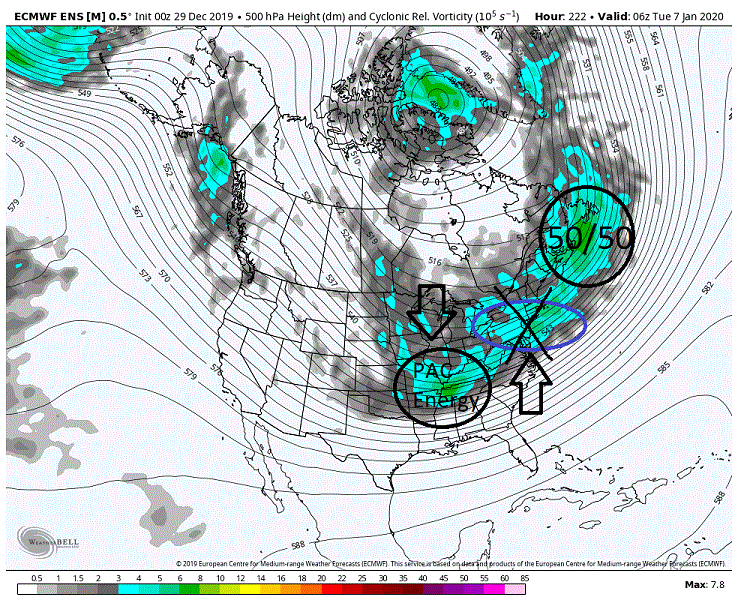
The potential for day 7/8 is still on the table. I wouldn't exactly call it a thread the needle type deal but we do need to see several things to occur for this to possibly work out. Below is the vort map of the EPS at day 7 to get an idea of the players on the field. What we are seeing is NS energy rotating through NE which will become out transient 50/50 as there is no blocking in place (-NAO). In the central US we see PAC energy which is rotating down and underneath the NS to it's north. Just above that we see NS energy diving down on the backside of the PAC energy. This is actually a pretty good look at this time and I would take my chances with this even though I would probably prefer a little more separation between the developing 50/50 and the trailing PAC and NS energy. If you move this forward what we see occur is a phasing of the NS energy and the PAC to our SW. At this time though everything is just a little north of where we would probably like it. Taken verbatim it is probably suggestive of a possibility of a period of snow on the front end before we flip to rain as the developing low would pass just to our N and W and this is reflected on the snow maps which favor snow to the north and west. What we are seeing here is damn close to a winning scenario. Now we have the 500's 12 hours later with a look I had hoped that we would see eventually morph from just a few days ago when it showed the broad NS trough over the central and eastern N tier of the CONUS. Again, this is a pretty good look though probably just a touch too far north/west with where we would probably prefer the phasing occur. Now first off, no 50/50 and we can probably call it quits. Or even if we see it wash out too soon as what yesterdays overnight EPS was suggesting is also not so good. It is the key thing driving the potential here. Above we see it is backing the flow somewhat so that we are seeing the beginnings of height builds between the two systems. These height builds are important to create a deeper drop and a quicker turning of the trough to our west. With a transient low we also need to look for the timing and the separation between these two features and at this time we are looking at a fairly small window. But there is one thing I will point out and that is we are seeing some height builds above the 50/50. This could come into play as it could potentially create a pseudo block for that 50/50 feature opening up a larger window to get the desired separation/timing we need between the two systems. Also note that we are seeing ridging building in the west. This is important as well as it is diverting the trailing NS energy in Canada farther east before it begins phasing with the PAC energy. If that ridging is slower to build we see the phasing occurring farther to the west (overnight Euro had this scenario) and we end up with congrats Chicago. One last thing, we do not want to see NS energy cutting in between the 50/50 and the phasing as it will more then likely result in a suppressed and progressive system as we saw with the overnight GFS.
-
After looking over the dismal overnight runs I decided to see if I could get any ammunition towards using the 'the models are probably wrong' excuse. So I looked into them somewhat this morning and I was honestly impressed with how the models have handled the longer ranges. Besides some occasional blips they were pretty much nailing the larger scale features and wavelengths. Can't recall them ever being this spot on before.
-
@psuhoffman Why are you apologizing? Thread is about discussion on the weather/models both good and bad. You are only stating what is staring us in the face and has been for a couple of weeks now. You know me, Glass Half full, Mr positive when I am discussing the weather. Well even I have struggled for awhile now to find positives on what we are/have been seeing. Hell, this morning about the only positive thing I could think of to say was, "Maybe the models are wrong?'. So keep doing what you do and though it might not be what people want to hear your logic/knowledge is sound (same goes with Chill). I myself am going to give it another couple/few days of runs in the hopes of seeing something positive otherwise I am probably going to call it as far as the first half of winter. Maybe even take another semi-break from the boards and the models for a couple of weeks.
-
Yeah, I caught on to the gallows humor. Now I am not saying I don't believe the MJO depiction and the PAC look. But I am also not necessarily saying I believe them. Just saying I don't know and am in wait and see mode. Some things I am seeing are leading me to believe that we could possibly see that troughing setting up farther east more towards the plains. If that is the case we potentially see the SE ridging morph more into a WAR look which would be more favorable for our cause.
-
Just a week or so ago the MJO had it exiting out of COD into 4 and transversing up through the warm phases through Christmas. Looking above we see that never occurred with it exiting into 6 and moving into the cold phases. So I would probably take what it is showing with a grain of salt. We have to remember that the same models that generate our pretty little maps that we follow and complain about never being right also generate our MJO forecast.
-
Not quite as bad. Interestingly enough, or maybe not so much considering the time of year, the 850 line presides for the most part in southern PA throughout the ridging. So it isn't such an insurmountable mountain to climb to get us on the favorable side of the boundary. eta: Of course any system amplifying will cut to our west with that look. We would be dependent on weak systems.
-
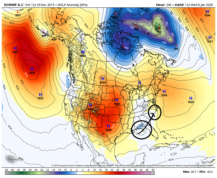
This is what we are seeing on the surface at the above time frame. The low to key on and with the most potential is sitting down around the Florida Panhandle, not so much the one in WV. The above trough and the surface pressure anomalies below would suggest that this would travel up towards at least OBX if not farther north. But we are talking an op at 10 days so it isn't really worth much.
-
Maybe, maybe not. Seeing a quick turning of the trough axis which would favor this coming up the coast to a point.
-
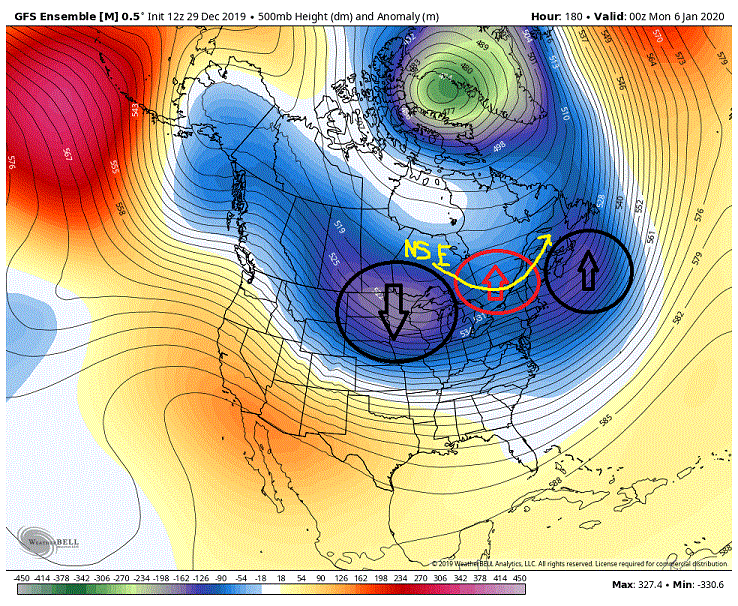
GEFS actually showed some promise. We are now seeing separation with the neg anomalies. Note the greater neg anomalies through the 50/50 region and those dropping down into the Plains. Also now seeing the slightest hints of ridging between these two features (red circle). One thing we don't want to see in this setup is NS energy running in between these two features (yellow arrow) through where the ridging would setup.
-
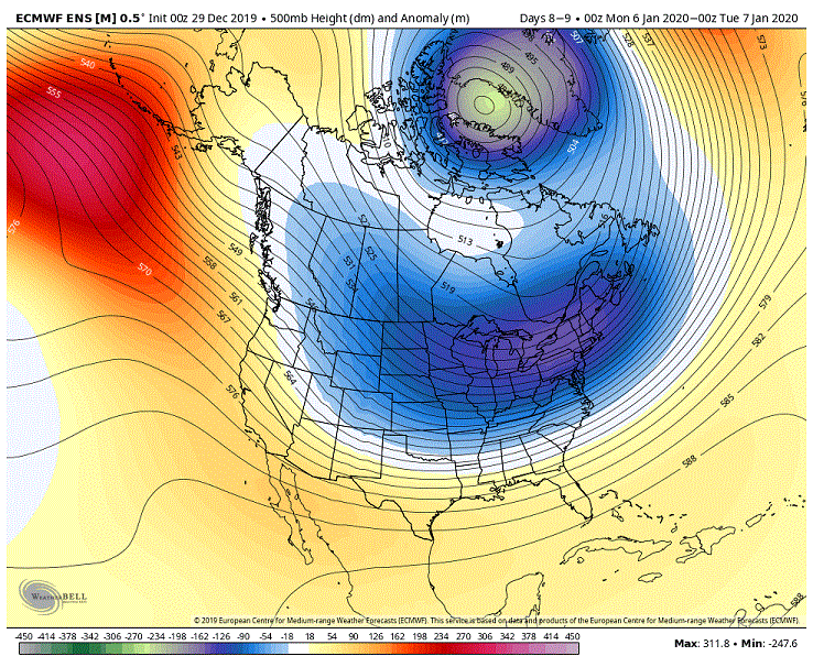
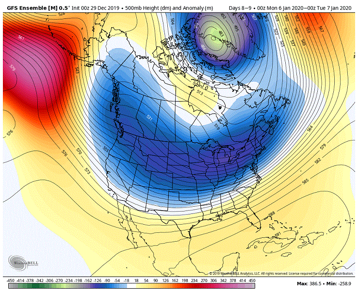
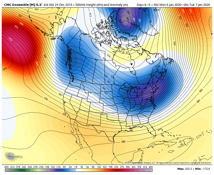
But SE ridging would be in response to troughing into the SW. We are not currently seeing that. At worst we see the GEFS a little heavy handed with the trough favoring through the Plains. And as far as a -PNA we actually have a neutralish to a slight positive leading into the day 9/10 period. Now could we see the models flip as far as what we are seeing in the West? Sure. But given the progression I am seeing within the NS, carving out the trough farther and farther East, I strongly doubt it. This is a pretty good look setting up for us at this time (eta: when you consider the response we would see if a 50/50 is inserted into this look of which the models are starting to key on, especially the EPS) and it has been improving run over run to boot. I have a sneaky suspicion that we are going to start seeing the models hitting fairly hard on the potential if this look continues. But that said it takes more then a favorable wavelength pattern to score. Much will be dependent on the timing with trailing energy after the initial NS push through the region as well as if we see the NS drop in prematurely and wreck the setup by suppressing the trailing energy.
-
Saw your to my post. I take it you disagree with me? I am just not sure how you see a cutter with any amplifying system with the look all 3 models are throwing at us at this time on our possible day 9/10 storm.
-
Really not feeling a strong west based -NAO at this time as the models seem pretty insistent on placing the PV in that general local. But it is still workable. Give us some form of central/eastern based -NAO to help shove that pv farther S/SE then currently depicted and we will see the NS suppressed farther south pushing the boundary along with it. The potential is there for a gradient pattern setting up and all we need is to be on the winning side.
-
That's one way. Drop the PV a little farther to the south/southeast is another. Also suggestions of cooperation in the N Atlantic as well. Really wouldn't take much in the way of tweaking with any or all these features to put our region into play as it shifts the boundary a little farther south. Those in the SE (central/southern VA and south) though are more then likely SOL because we are more then likely going to see that SE ridging rearing its ugly head for them.
-
Think I would disagree with this. 500's being depicted at this time would suggest any amplification of a low would occur in the East vs. OV. Bigger fear in my mind would possibly be suppression.
-
Thought for the last couple of days that the period, what is roughly now centered on day 9/10, had some promise on the ensembles. From what I am seeing the models are starting to pick up steam on that idea. The EPS, GEFS, and the GEPS all vary somewhat on the general setup leading into this window (in particular the initial NS drop, placement and timing) but they all agree on two key features that open up this window. And that is rotating a low, induced from the initial NS push into the east, through the 50/50 region around day 8 as well as trailing NS and Pac stream energy. Now all 3 models vary somewhat on the evolution but they all show potential none the less. Now at this point the smoothing we see at the somewhat longer ranges on the ensembles is somewhat muting the look here but the fact that we are now seeing the ops with their finer detail picking up on a storm is very promising. Thought I would throw up one map from the EPS that showed what I thought was the most promise though I am not taking away from the other two models that showed promise in slightly different ways. Now what we have is the vort map at 500's here. Notice that we are seeing strong returns in both the 50/50 region as well as to our SW. Now this is where the smoothing/conflicting signals comes into play as we are also seeing somewhat strong returns just off the coast (blue circle). This is some of the ensemble members seeing a storm (probably some form of a Miller B from NS energy riding on the coattails of the initial NS energy and blowing that up). Now this suggests that the EPS is seeing two camps here. But take the Miller B camp out of the equation and instead of the smooth height lines we see running through the east and off the coast what we in fact would have is an amplification of the pattern with ridging developing between the 50/50 energy and the energy to our SW. We would also probably see a deeper drop of the trough associated with that SW energy. Needless to say that look would be a very promising one for the mid-Atlantic. Now seeing as some on here want predictions (ahem.... @leesburg 04 ) I will go out on a limb here, at least as far as one can go on a day 9/10 forecast. If we see the models continue with the idea of a 50/50 rotating through on the lead up as well as PAC/NS energy lagging behind I strongly believe we will see a storm here in the east. Now whether it is a Miller B earlier in the period or a southern/coastal low later is still up for debate. BUT..... if we can keep NS energy from running interference between the 50/50 and the energy running behind a day or two later there is potential here for a fairly significant storm for our region and up to our NE as a low to our SW has the potential to go Coastal. ***Just a quick aside. I know some on here are panicking when they are seeing looks like this at the end of the extended. Maybe hold off on that for a few days because I don't think it is as dire as one may think. Though at this time they may favor 40N they are by no means what I would consider a shutout pattern for us especially considering the time of the year. I would also like to add that it wouldn't take much in the way of adjustments with some features to actually turn this into a somewhat favorable look for us. Will try to post something later today or tomorrow explaining what I am talking about.