showmethesnow
-
Posts
7,250 -
Joined
-
Last visited
Content Type
Profiles
Blogs
Forums
American Weather
Media Demo
Store
Gallery
Everything posted by showmethesnow
-
Really hard to get an accurate reading on what I got with the squall around 7 due to the winds but am going with 1.25" which is more then likely low. Looking at radar and it looks as if I will have another one roll in shortly.
-
It's hammering here right this second. Probably one of the better snow squalls i have seen in a long time. Some gusts of wind thrown in as well. Wouldn't be surprised if I can pick up a quick inch or two when I look at the radar.
-
Nice snow squall moving through here now. Great rates (better then what I saw yesterday that had some very good rates) with snowflakes reaching half dollar size. Probably have picked up close to a half inch in the last 15 minutes.
-
And I am hungry. eta: And I mean it. I could go for some eggs and bacon right now. Well bacon mostly. Kind of reminding me of a thunderstorm rolling in here. Clear skies beforehand with a bank of clouds that just moved in overhead. Several gusts of wind came in as well. Just waiting for the snow to start falling at this point.
-
I can live with this look in the extended on the EPS. Very workable pattern and is a tremendous upgrade to what we expecting to see just a week ago. The GEFS though is still somewhat rough as it continues to be heavy handed with the troughing into the SW and off the coast. But even that is workable towards the end of the extended though it would probably more so favor 40 north at this time.
-
We are always searching for that perfect pattern but I bet more then half, if not 2/3rds of our snow come in flawed, if not severely flawed patterns. Maybe I should ask @psuhoffman, he always seems to have the numbers.
-

Mid Atlantic 2019/2020 season snow totals
showmethesnow replied to Midlo Snow Maker's topic in Mid Atlantic
Winter of 19-20 Running snow totals. ******************************************** Dec 4 (Early morning hours): 1/2" Dec 11 (Early morning post frontal snows) .6 " Dec 16 (early morning hours, overrunning) 1.0" Jan 7 (Quick hitter roughly 6 hrs in the afternoon) 4.5" Jan 8 (early morning squalls.) (Squall 1) 1.25" (Squall 2) .6" ******************************************** Total for season: 8.45" -
Nice little event up this way. Going with 4.5" as the final total.
-
You must be married too then.
-
Virgo? Is that like a virgin?
-
Pushing 4 inches here in Hanover with moderate to almost heavy snow still falling. Maybe another 1/2 hour or a touch more before it shuts off.
-
Ah, and now we have pictures upside down.
-
Was wondering the same thing. Sort of reminded me of @WxWatcher007 who had so many issues with posting pics/images last year. Can't figure out how an old fart like me has no issues and yet these youngsters who had computers in their cribs can't get the hang of it.
-
How do you keep the snow from sliding away?
-
Wasn't too good up in my neck of the woods as I started as snow and stayed as snow and yet it was showing rain past Gettysburg this whole time until just a few minutes ago. Pretty large margin of error.
-
Roads are starting to cave here in Hanover with roughly an inch so far and moderate snow falling. Temps have dropped from 37.5 to 33 degrees since the snow started roughly an hour ago.
-
Okay, I admit. You did make me look.
-
Woke up at 3 am to 31 degrees. Have risen a degree and am now sitting at 32. Probably the result of the cloud cover moving in overhead that I could see just starting to obscure the moon as it was setting when I woke up.
-
The biggest issue I see on the latest GFS run is that it has backed down on the lift through central MD that we were seeing on prior runs. Not sure I buy it though when I look at the latest 3K Nam and especially the 12K.
-
06Z looks a little rough. Looking 95, DC up to Balt, before onset we are seeing deeper low level warmth (Above 0, 925mb and down) vs what I saw on previous runs of between 975-950 mb. Sort of looks to me that it is taking the initial thump to cool the column down and by the time it does that the best lift has already exited the region.
-
What!!! You aren't chasing? Bought the beer and had a guest room setup for you. Guess I will have to drink that quality and expensive beer on my own then.
-
Guess it was to be expected, but this system has pretty much morphed into a Fall line special (95 and N and W). Fully expect to see the death band to set up where we typically see it (PSU land hooking around S and W). Probably see 4-5 inches, with a jackpot or two of 6, through this region as we should see some 12-1+ ratio snow. There is one thing that could possibly knock these totals down somewhat. And that is if they were to lose some of this to low level warmth and rain considering that the precip comes in hot and heavy from the start. Really don't expect to see that except for maybe a few spritzes initially. Cities are probably good for an inch or two as well though they could surprise if we can limit the low level warmth before the onset.
-
Nothing would surprise me anymore when it comes to the school systems these days. Not like when I was growing up and we would all be gathered at the school windows watching the snow fall heavy with 3-6" already on the ground counting the time until school let out. Normal time no less.
-
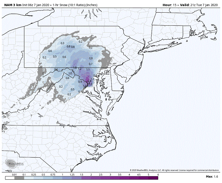
If the 3K Nam is to be believed N DC and portions of Montgomery and Howard county will get the bulk of their snow within an hours time. 1.5-2 inch rates are showing up during the later commute between 5-6 pm. Might be a good day to leave work early.
-
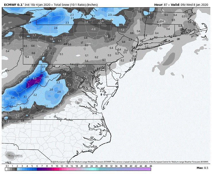
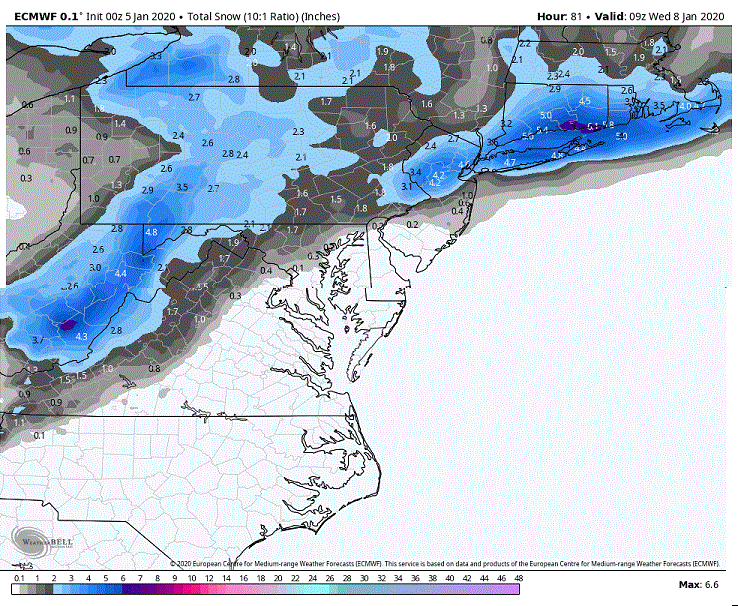
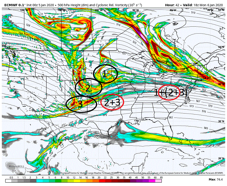
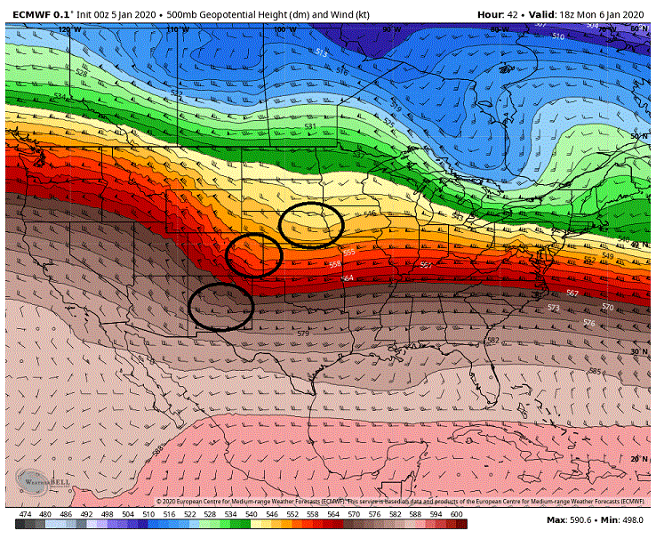
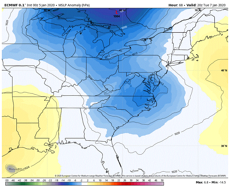
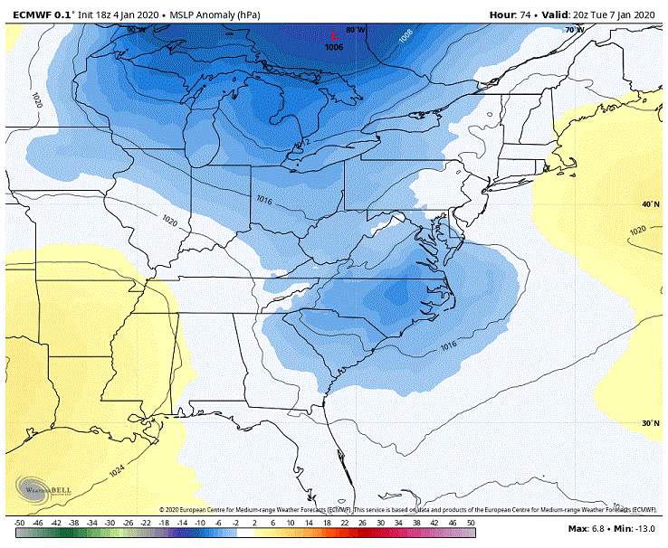
Our Tues storm and what to expect will probably come down to how 3 packets of energy/shortwaves are handled as they progress eastward through the CONUS. Using the overnight Euro to show you what I mean. Probably somewhat hard to see with this map but what we have are 3 shortwaves embedded within the trough below. Looking at the vort map will give you a much clearer picture of where these shortwaves are located. Now what we see in our region will be dependent on how these three packets interact/don't interact as they progress eastward. What we saw with the overnight Euro run is that there was pretty good cooperation between the three. Though it wasn't the cleanest of phases we did see energy packet 2 drop down on top of #3 over Oklahoma. Packet (2+3) then progressed eastward to where we then saw #1 drop down (again not the cleanest of phases) into it over W Kentucky/W Virginia. This cooperation between the energy helped to create a deeper drop of the 500's into the shortwave as well as a quicker turning of the shortwave as to where we were seeing it reach neutral status in the mid-west going negative through our region. The repercussions of the changes in the 500's on the surface with our storm can be seen below. Note that we are seeing stronger low pressures that have been shifted northward over the previous 18z run which is to be expected given a more favorable 500s for storm intensification. Now seeing a stronger system is a double edged sword. It gives better rates to help overcome the lower level warmth for those that can stay in the snow sector but it also will tend to pull a system farther north compared to a weaker low. And you can the results of this below. Note that we are not only seeing better snows to the N and W due to the better rates but we are also seeing a decent swath to our NE as the low intensifies quickly enough to pull it up the coast vs. the previous run with the weaker low which headed OTS. Looking over other models we are seeing quite a variance with how they want to handle these 3 packets of energy. Pretty much goes to show that what to actually expect come Tuesday might very well be close to a game day call.