

showmethesnow
-
Posts
7,250 -
Joined
-
Last visited
Content Type
Profiles
Blogs
Forums
American Weather
Media Demo
Store
Gallery
Everything posted by showmethesnow
-
Everyone? You mean maybe some were? I know I was no where close to canceling anything especially considering we were in early January. Been at this too long to get caught up in all the hype (both good and bad) we see sometimes.
-
Bigger storms all the way. And this isn't so much because I am big game hunting, which I always am , but more so because I think the odds are better if we go that route. Right now from what I am seeing on the models the trough positioning looks to set up a little too far east for progressive systems and I have a fear that if we don't see some form of blocking to slow the flow we will run the risk of seeing systems suppressed as they run to our south (Congrats S VA/N Carolina). But on the other hand the trough positioning is pretty much primo for systems if they amplify which we would see with blocking. And I don't necessarily believe it would be a one shot and we are done deal to boot. Could be a case of one system amplifying and nailing us and then providing a transient 50/50 for a follow up. And seeing as the models at this time are suggestive of this general setup being locked in for awhile beyond the end of the extended it would provide potentially a wide window to score when we could possibly be talking transient blocking. So Big Dog all the way as far as I am concerned.
-
Yeah. So besides the obvious, trough/closed low undercutting ridging, you can also get split flow setting up when you start seeing large gaps between height lines.
-
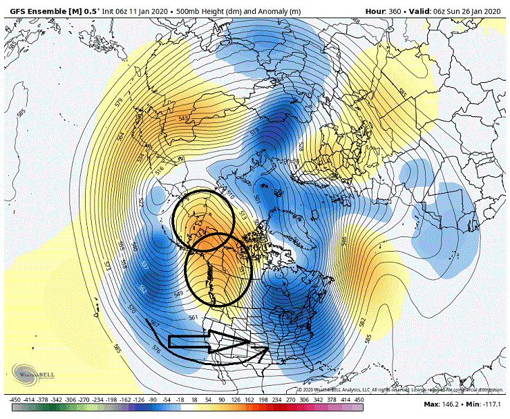
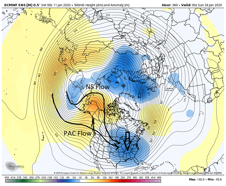
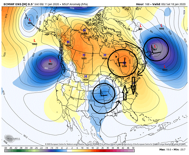
Thought I would add something. PSU threw out analogs out the other day that weren't promising for our snow chances as far as a -EPO/+PNA combo. Good reason for that as that pretty much overwhelms the flow throwing a deep trough into the eastern portion of the country. This look is not what he is referring to though. Now this look above would clock in as a -EPO and a fairly strong +PNA. This is where looking at indices alone can be misleading. What we actually have is a -EPO and a very strong northern based +PNA. If you notice to the south we are seeing a flat flow with hints of a split flow and southern stream involvement. This is actually not a bad look at all if we can get some backing of the flow in the east (believe PSU mentioned this as well on his analog post about needing blocking up top) otherwise we are looking at progressive systems.
-
That look is more favorable for SS interaction. Up in the PAC west/EPO region we really aren't seeing much of a split of the flows as the distance between the height lines are staying uniform.
-
Really am starting to like the potential of what we are seeing beyond day 10 on the models. And beyond the end of the extended as well as this has the looks of something that could setup for a time. Will pretty much be dependent on if we can get something to slow the flow in the east (NAO/50/50). We see that and I think we are ripe for a fun time.
-
Another area we might want to keep an eye on is what we see in the PAC NW. Think given the current setup in the longer range this has better odds of producing then from the weak split flow showing up off the SW coast. What we are seeing is a split flow up over the EPO ridge with the NS and this is being undercut into the PAC NW by the PAC stream. With the troughing/piece of pv to the west providing ample energy to both streams. Given the current setup with a fairly aggressive trough in the east this is actually a good look for potential..
-
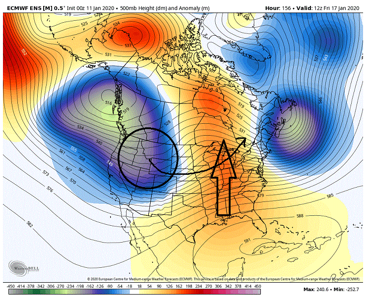
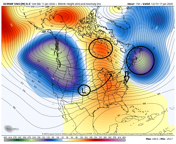
My initial glance at the EPS leading into our potential storm for next weekend was pretty much a, 'Oh crap' moment. Stronger height builds and ridging in front of our incoming system compared to the 12z and we were also seeing the NS with a weaker dig and a farther west track on its eastward movement. Height builds were pretty much suggestive of more warming leading into the system . As far as the NS track it pretty much takes the low running through our region or to our south off the table. As I said, it was a, 'Oh crap' moment. But diving into it a little bit and I realized it was actually a more promising look for frozen through our our region. What I didn't initially pick up on was that we were seeing much stronger height builds over top around the Hudson Bay which was translating to stronger higher pressures on the surface in Canada. We were also seeing the a stronger, slower and farther SE signature on the 500's through the 50/50 region. This setup is actually a fairly decent upgrade from the 12Z for maintaining CAD (cold air damming) in the east. One other thing, with the farther west track of our surface low the stronger southerly flow at the lower levels also shifts farther west making it that much more difficult to scour out the CAD. And below you can see the surface representation 12 hours later when precip is starting of what the 500's above produced. Strong high over top with a 50/50 helping to slow it down. This combo is producing a strong CAD signature east of the Aps. Farther west low is keeping the stronger southerly surface flow west of the Aps. Not surprisingly we saw an increase on the snowfall maps (looking at them more so for the frozen potential then for actual snow). The run was actually close to an all frozen event (snow, sleet, freezing rain) for N and W of the cities. Throw in a little better temps in the lower levels for after we lose the mids and we are talking Fz rain or sleet to end this.
-
I'm all.... At least until tomorrow.
-
Pretty good signal for being 12 days out for the 22'nd.
-
After just looking over the EPS I think I will jump on the Bus as well. Ignoring anything beforehand, day 10-15 looks very good. And as the pattern looks as if it is setting in one would have to believe that look extends a good deal beyond day 15. Good times. At least until the next run.
-
Fell in love with Maine after our vacation this summer on the coast. Farthest north I had ever been until then was Salem a couple of times on one of my many visits to Cape Cod. I can see getting something 3 /4 hours off the coast where the maritime influenced is muted quite a bit for heavier snows and putting our trailer on the coast (love the coast) for summertime enjoyment.
-
Screw up slope. I am talking one of the two KU's we are going to get in February. Just hoping we can time one of them up around a weekend.
-
That is hopefully my wife and myself in a little under two years. Considering two places at this time. Upper Laurel Highlands in western PA and Maine a couple of hours off the coast where real estate is cheaper and the snows are deeper. Looked into some other NE states but I wasn't particularly fond of their taxes and their current fiscal issues that probably foretold ever increasing taxes. Will revisit everything a year from now so the above may change.
-
But a short bus would bring back so many fond memories. Actually told my wife last night that we were going back to Rocky Gap Casino/Hotel in Cumberland MD for my B-Day in February. Am going to try to time a good storm around a weekend and hopefully get snowed in. Loved it up there.
-
Your professional help comes from these boards? With all the whackos no wonder you are so warped. Maybe you should get professional help for your professional help. I would consider it myself but it is far to late for me.
-
Speak for yourself. As PSU would say, Move north young man, move north. Think this may be why we are seeing the GEFS having issues with the weekend. It isn't sure what it wants to do Thursday as of yet.
-
You should probably seek professional help for that.
-
Don't look now but some of the things I am seeing have me wondering if the GEFS is considering trying to bring something up from the south as the cold front pushes through on Thursday.
-
Was a decent look but I am not sure how much I trust the GEFS at this time. It is all over the place with the timing the last few runs.
-
I liked what I was seeing on the EPS. Seeing the changes we need to see and a move in the right direction for more frozen. As far as the GEFS, it is still in flux with what it wants to do. So for now I am riding the EPS.
-
Until I can experience it I am going to consider it Fake Snow.
-
Probably would worry more about what the ensembles saw and from what I see they were a win. Less emphasis with a cutter into the lakes and more emphasis with forcing low pressure to the East. Seeing better High Pressure over top the storm (more of a banana high). Also like the 50/50 low positioning better as well. eta: My bad, actually was only referring to the EPS.
-
But it's Fake Snow. https://buffalonews.com/2019/11/14/don-paul-remembers-the-november-storm/
-
Picked up another .6" in about 30-35 minutes with the second squall. Neat little storm as it was predominately popcorn snow and only towards the tail end did we see it flip over to fluffy dime sized flakes. I am thinking you are right especially when I see the totals some have gotten around me. Caught me by surprise so I really didn't have a chance to set up an area for measuring. Just hate claiming something I can't verify.


