

showmethesnow
-
Posts
7,250 -
Joined
-
Last visited
Content Type
Profiles
Blogs
Forums
American Weather
Media Demo
Store
Gallery
Everything posted by showmethesnow
-

Mid January/Mid February Medium/Long Range Discussion
showmethesnow replied to WinterWxLuvr's topic in Mid Atlantic
Looking at the sounding for around Winchester there is a good reason it is showing rain. It shows above freezing temps from 875 MB down to the surface. Might get some snow flakes mixed in on heavier bursts but that is pretty much a rain sounding.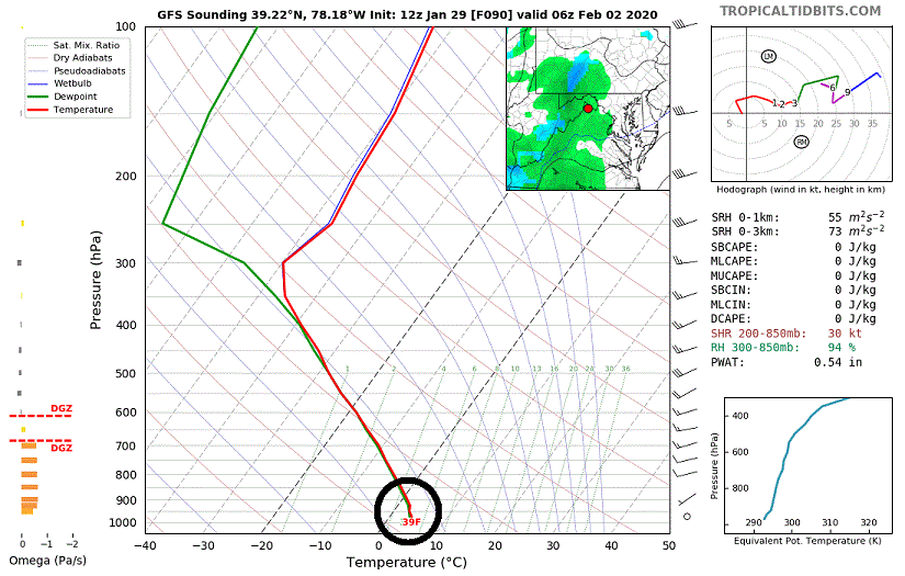
-
Do you know what is also really annoying??? Hope I don't have to spell it out for you.
-
Mid January/Mid February Medium/Long Range Discussion
showmethesnow replied to WinterWxLuvr's topic in Mid Atlantic
How much deeper do you want the trough? As it is now it is all the way down into central Mexico. So are you talking like Central America deep? -
Mid January/Mid February Medium/Long Range Discussion
showmethesnow replied to WinterWxLuvr's topic in Mid Atlantic
I am thinking the odds of that SS energy/Storm lagging behind are much better then you stopping your Hissy Fit. By several orders of magnitude. -
Mid January/Mid February Medium/Long Range Discussion
showmethesnow replied to WinterWxLuvr's topic in Mid Atlantic
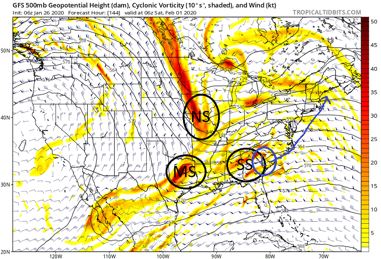
The latest Euro is showing exactly what we want to see for this weekend. Notice the deep, deep drop we are now seeing in a very favorable locale for our region. If we were to see that SS energy/system running in front of it lag back another 6-12 hours we might very well be talking game on.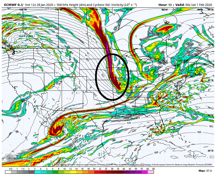
-
Mid January/Mid February Medium/Long Range Discussion
showmethesnow replied to WinterWxLuvr's topic in Mid Atlantic
What we saw on the overnight EPS and the CMC was that they are handling the trailing NS energy differently then they have been the last few days. What we were seeing was them tracking that energy across southern Canada before dropping it southward through the lakes (red line). That is if they even dropped it at all. The overnight runs though are now seeing it dropping down much farther to the west through North Dakota (black line) which is in a much more favorable locale for possibly phasing in the east. Not only that but they are also picking up on this energy being stronger then on previous runs. They are pretty much moving once again toward a look that drew my attention to this time period a week ago. But, no surprise here, the GEFS after having this farther west drop the last few days now has moved away from that on the overnight run. Go figure. Now this is important to hopefully get cold air in play for our possibly storm otherwise we are probably pretty much sucking wind for our snow chances outside of those with elevation. Now there is much more in play besides this NS drop. If you notice that big blob of energy down in the south as well as that stream of energy (blue line) running down into it. What happens there will also play a big part in determining the final outcome. If we can see some sort of phasing between all the different packets of energy as to where we can get a strong shortwave on the base of the trough this will help to draw southward the NS energy hopefully putting it in a better position for a possible phase. But as far as what we will eventually get down in the south, I have no idea. Just to much going on to get a clear picture. One last thing I will point out. The shortwave in the northern portion of the trough (?). Right now it is basically playing traffic cop and shunting the NS energy southward. So the stronger the shortwave the farther west and the deeper the drop of the NS energy. But this could also play as a wildcard if we can see a much deeper drop as to where it starts influencing the southern portion of the trough (eta: It also may help to get colder air southward as well). There is really a lot going on and to think the models have it nailed down at this time is probably wishful thinking. Now do I believe we are going to see a snowstorm for our region? Probably not as I would probably put the odds on the low end as we need too see much go right. But is it possible? Sure is.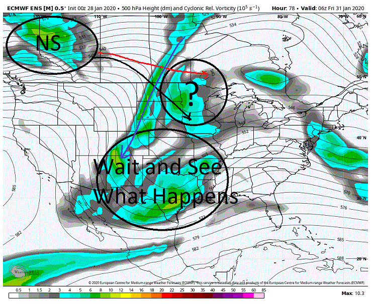
-
Mid January/Mid February Medium/Long Range Discussion
showmethesnow replied to WinterWxLuvr's topic in Mid Atlantic
May not look it on the surface for this weekend'a possibilities but we saw an important change at 500's on both the Euro and the CMC dealing with the trailing NS energy. Will post something shortly explaining what I am talking about. -
Mid January/Mid February Medium/Long Range Discussion
showmethesnow replied to WinterWxLuvr's topic in Mid Atlantic
Not that I am particularly an ICON fan but it does throw out a pretty snowfall map from this mornings run for those N and W of the cities. This is all SS (southern stream) driven. *It's a 10-1 map so chances are very good the totals are over inflated considering the temp profile leading into and during the storm.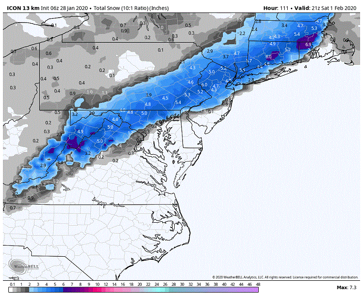
-
A good chunk of the 70's come quickly to mind. Try being a kid who loves snow having to endure that. Flat out sucked most of the time.
-
Been too depressing in here for awhile now with the model disco almost unreadable most times. Hard to enjoy that. Add in the fact I really didn't have much in the way of positive vibes to add to the discussion equals me taking a timeout for awhile excepting some casual lurking. And no, I don't need a Reaper call.
-
Mid January/Mid February Medium/Long Range Discussion
showmethesnow replied to WinterWxLuvr's topic in Mid Atlantic
The sounding is crap though. This is for up around Hanover and temps are above freezing from just under the 850's all the way down to the surface. Awful deep warm layer to try to overcome even with very good rates. And the soundings get even worse as you move down towards DC. Only finally see improvement as the surface and lower level winds shift from the north as the low is pulling away.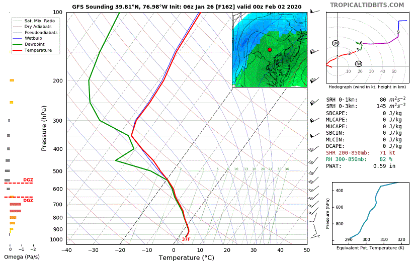
-
Mid January/Mid February Medium/Long Range Discussion
showmethesnow replied to WinterWxLuvr's topic in Mid Atlantic
500's and surface improved (vs. the 12z run). Reflected on the snow maps as we saw an uptick on the snow.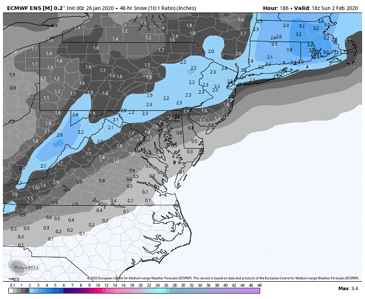
-
Mid January/Mid February Medium/Long Range Discussion
showmethesnow replied to WinterWxLuvr's topic in Mid Atlantic
The morning GFS spit out a solution that was oh so close to potentially a very good outcome for our region. Typically don't give much weight to op runs vs. ensembles outside of 5 days but in this case with the key players on the field just outside of 5 days and the op runs finer details with smaller scale features vs the smoothing of the ensembles i might make an exception. Below we have the vort map leading into our east coast storm. We have 3 pieces of energy to take note of (North stream, Mid-stream and a Southern stream). What we see here just misses from being a triple phaser in a very favorable location for our region. What we have is the MS dropping down the backside of the SS with the NS waiting in the wings in a favorable locale to drop down the backside of any potentially phasing of the MS and SS. Unfortunately what we see on this run is that the SS escapes too quickly to the east and the MS misses it. This leaves the NS dropping down with a shallower drop and we see no phasing between any of them. You can see the result on the second map below. But as I said, this was oh so close. Slow that SS energy down by 6 hours or speed up the MS by 6 and we do see a phase between the MS and the SS. We see that initial phase and then then chances are good we would see a deeper drop from the NS as it gets drawn into the initial phase giving us a triple phaser in a favorable locale for our region. Now I know the issue is/has been the temps leading into the system. But if we were in fact to see a triple phase with the general overall trough setup displayed below I don't think temps would be an issue besides the initial onset of any precip. Would probably be a case of rain to wet snow to dry powder. And this is due to the fact we would see the NS bring with it the colder air needed in the upper levels. Biggest initial handicap would be the lower and surface level temps but more then likely they would be quickly overcome. Now you may look at the surface compared to the upper levels and say, 'but the surface low pressure is already exiting the scene before the cold air can arrive. But if you look at the second map below what we are seeing is that the low pressure is forming on the lead SS energy that is running ahead of everything else. BUT... if we had seen that SS 6 hours slower with a phase. We would see that surface low delayed as well giving time for the cold to catch up to it. Conversely, if we had seen a 6 hour quicker MS energy and phase with the SS chances are good we would see a quicker response eastward from the NS and bringing the cold with it. Pure conjecture on my part, but if we would have seen slower SS energy (quicker MS) I could very well have seen this end up being a bombing low somewhere between OBX and OC as the 500's catch up and start stacking to the surface with a track leading up to the bench mark.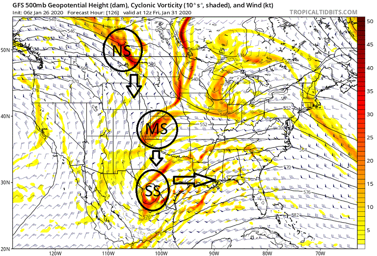
-
Mid January/Mid February Medium/Long Range Discussion
showmethesnow replied to WinterWxLuvr's topic in Mid Atlantic
Next weekend actually has my interest somewhat. At least as far as how interested you can be with something 9/10 days out on the models. The models are starting to pick up on a piece of potent NS energy diving down into the US in a somewhat favorable local for our region. Pretty much will be dependent on what we see downstream in the south and the east coast leading into that NS drop. Lot of moving parts but the general idea is there for a pretty strong system somewhere in the east. Of course the models could be out to lunch once again. -
Mid Atlantic 2019/2020 season snow totals
showmethesnow replied to Midlo Snow Maker's topic in Mid Atlantic
Winter of 19-20 Running snow totals. ******************************************** Dec 4 (Early morning hours): 1/2" Dec 11 (Early morning post frontal snows) .6 " Dec 16 (early morning hours, overrunning) 1.0" Jan 7 (Quick hitter roughly 6 hrs in the afternoon) 4.5" Jan 8 (early morning squalls.) (Squall 1) 1.25" (Squall 2) .6" Jan 18 (slop storm) .4" snow/sleet .2 ice ******************************************** Total for season: 8.85" -
Sadly no they don't.
-
Hanover is the place to be. If you come up I can guarantee a minimum of 6 inches. Of course it might be a localized event, very localized, say in my back yard? Around the snow making machine I would buy to guarantee those 6 inches?
-
You are on a long list of those who got to enjoy one of his tirades. Quit following a few years back myself. Got tired of his constant trashing of other Mets, interjecting politics into his discussions and trashing any that disagreed with him. Shame too because he is very knowledgeable if you can ignore his constant model hugging of the Euro.
-
Got you. Didn't look in depth was just a quick and dirty glance after seeing your post. Nice post on the mid-level winds by the way.
-
Are we looking at the same thing? 06Z looks comparable if not just a smidge wetter then the 00Z on precip total. Now admittedly both runs are dryer then the other models but still I didn't see a degradation.
-
I like what we are generally seeing in the longer ranges on the EPS and GEFS as it does have potential. But we will probably be dependent on well timed systems and/or episodes of some sort of blocking in the N Atlantic to realize this potential. Otherwise we are running the risk of progressive and suppressed systems. On the other hand we are seeing an active southern stream that could very well come into play as well. I would definitely roll the dice on what we are seeing now as there is very good upside if things break right for us. And it sure beats what we were looking at just a few weeks ago.
-
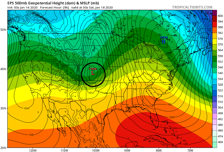
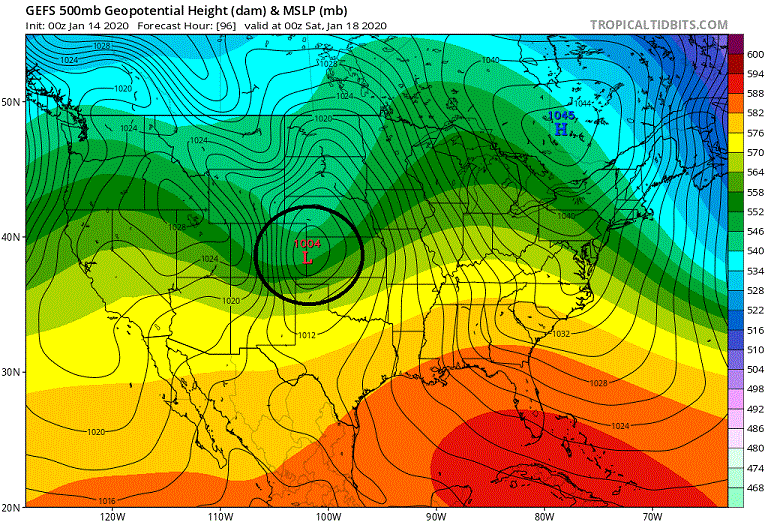
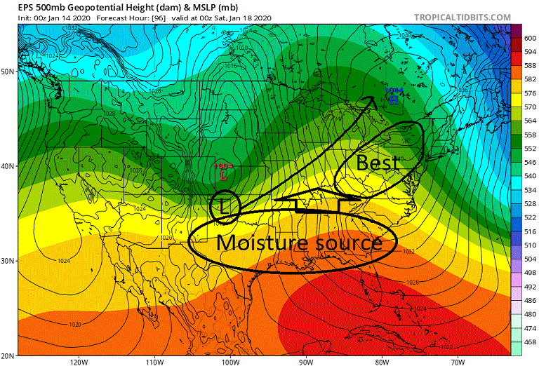
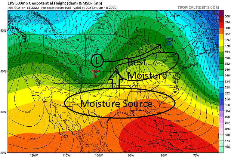
I know some on here are rooting for a shallower drop of the trough in the west. At this time with what is being presented on the models I am actually rooting for a deeper drop. Let me explain. Below we have the GEFS and the EPS at 96 hrs. What we have is the trough moving through a very broad area of lower pressures in the west. What I want you to note is the location it is deciding to initiate the development of our primary from within this large expanse of lower pressures. What we are seeing on both the EPS and the GEFS is that they are having this development on the base of the trough just on the front side. And for the most part this is what we have been seeing for the last 2 days or so on these models. Now some may argue that this deeper drop is pumping up the ridging in front and thus the warming the temps hurting our chances for frozen. I don't really think that is a concern at this time. If you notice we have a very strong CAD signature and that will be very hard to erode out especially with the farther western track we are seeing with our low. I think at this point our far bigger concern is actually getting some decent moisture overrunning our CAD vs. any potential warming. This is where the trough drop and the primary development come into play. What it basically comes down to is the track of our low. Below is what we would be looking at with a shallower drop of the trough assuming that the primary initiates on its base. What we have is a good moisture source running through the southern tier of which our low will be tapping into. With the low being farther north it has a harder time tapping into this source. What we also see is the best moisture is following to the south and east of the track of this low. There is a very real danger with this of seeing the best moisture to our west and north in this scenario. But look at we see with a deeper drop. The low is better able to tap into the southern moisture giving us a better moisture feed then the above. Also note that the track is more favorable to getting that good moisture flow running through our area.
-
Looking over the EPS and the changes seen from the 12Z were minimal. Western trough is slightly quicker but it is somewhat of a wash as confluence and associated High pressure to our north is a touch quicker departing as well. High pressure to our north is a touch weaker and our system is also a touch weaker as well with a similar track as the 12z. Accounting for the slight differences on timing with precip (00z is a touch quicker) the CAD is almost spot on to the 12Z. All in all what we saw was pretty much noise from run to run. As far as the snowfall means we did see an improvement. Saw a roughly 1/2" increase over the 12z from just south of the cities and north.
-
Let's see where we are in a day or two. But as of right now with what is being depicted I wouldn't expect to see any transfer to off our general coast as the primary is still gaining too much latitude. See stronger heights in Canada on future runs with less latitude gain and/or a deeper dropping trough then we can probably start considering the idea.


