

showmethesnow
-
Posts
7,250 -
Joined
-
Last visited
Content Type
Profiles
Blogs
Forums
American Weather
Media Demo
Store
Gallery
Everything posted by showmethesnow
-
Watch list? Reaper call? I keep telling you. You are just too timid. Go for the jugular.

-
Knowing you on these boards I think my vote would go to weirdos.
-

Mid January/Mid February Medium/Long Range Discussion
showmethesnow replied to WinterWxLuvr's topic in Mid Atlantic
I remember the days where I lived and died with each op run all the way out to the end of the extended. Would analysis each run into the smallest detail. But after 25 years of tracking I have learned that it is typically an absolute waste of time. There is very rarely anything to glean from them unless you are looking for something in particular to back what the ensembles are showing. So now I very rarely look in depth on the ops outside of 5 days let alone at 10+ days unless I have a compelling reason to do otherwise. Pretty much cursory glances and that is more so at 500's then the surface. Just wish more on these boards would take this frame of mind. It would resolve a lot of the heartache, headaches and angst we now see. -
Mid January/Mid February Medium/Long Range Discussion
showmethesnow replied to WinterWxLuvr's topic in Mid Atlantic
Good point. They have tended to overblow that feature. But they have been good with the general placement though they have on occasion shifted it slightly. And unfortunately just a slight shifting can have a major impact with our prospects. -
Mid January/Mid February Medium/Long Range Discussion
showmethesnow replied to WinterWxLuvr's topic in Mid Atlantic
Actually I have been somewhat impressed with the performance of the models this winter when it comes to the longer ranges compared to previous years. Probably one of the better performances we have seen. Generally they have had the long wave pattern nailed. Some might argue how they could be so good when they show a good look that turns into a bad look as they near in time? That pretty much comes down to two things. When the smoothing from the longer ranges starts easing and the finer/smaller scale features start popping up. And when they adjust some large scale feature slightly that are key for our region (think EPO/PNA). They were never really robust with the idea of a -Nao this winter though they had their moments. All in all I think it was one of their better performances over the years. -
Mid January/Mid February Medium/Long Range Discussion
showmethesnow replied to WinterWxLuvr's topic in Mid Atlantic
Same here. Though admittedly I have been somewhat lax the last week or so following the long range so there very well could have been a period time where the models were throwing up a more sustained blocking period. Tried to find some positives this morning in regards to the long range but pretty much came up with zip. Never had been high on the upcoming period but always felt that it did still present some possibilities. But the way the models are morphing any optimism is slowly waning. I do see a couple of adjustments that may make a difference but I am not really hopeful we would see them occur given the tendencies this year. Get the EPO to slide farther east enough where we can get a N Based PNA might do the trick. Or see a deeper drop S/SE of the pv to suppress the flow in the east. Or even just an extension of the PV towards the 50/50 region instead of farther to the N and E that we are currently seeing might do it. But as I said, I am really not hopeful on those prospects. At this point I am pretty much hoping that the models are flat out wrong. -
Actually there is typically a little lag between true solar minimum and the response in the AO domain. This is one of the main reasons I favor seeing sustained blocking (AO domain) showing up in the near future. Now whether it translates over into the NAO domain is another question. Couple of things I saw this fall while taking notes for my winter forecast (that I never finished because of time constraints) though gave me the impression that odds were good we would see a favorable NAO regime setting up shortly.
-
Mid-Atlantic winter 2019-20 snowfall contest
showmethesnow replied to PrinceFrederickWx's topic in Mid Atlantic
@PrinceFrederickWx: Mrs Showme, Mrs Showme? Excuse me but I have been trying to get in touch with Coach Snowme. He hasn't been available to receive me for quite awhile now and I would like to discuss what his plans are in regards to turning things around. Mrs Showme: Well Prince, he has been very busy in that regards and I can assure you he is working diligently and leaving no stone unturned. Showme: -
Does the white all through our region mean lots of snow?
-
When looking over things this Fall for the coming winter I had a different impression as far as the NAO in the coming years. Got a pretty strong impression we were on the verge of a sustained winter time -NAO regime for the next few years. The bigger question in my mind was whether we would see it manifest this year or not and the signals in that regard were mixed. Obviously it was a Fail this year but for next year I actually have some high hopes.
-
Hmmmm..... Next get together at PSU's you better be bringing some serious stout to share with me or I am tattling.
-
God I'm slow. Kept seeing you pop up today and all I could think of, 'Who's this new dude/dudette?' Finally dawned on me just this minute what was going on.
-
Mid January/Mid February Medium/Long Range Discussion
showmethesnow replied to WinterWxLuvr's topic in Mid Atlantic
I am not overly enamored with what the EPS has to offer at this time as well. But it is a look that can potentially work. We really won't know what we have though until we get much closer in time and the smoothing decreases enough where we can start seeing the finer details/smaller scale features. -
Mid January/Mid February Medium/Long Range Discussion
showmethesnow replied to WinterWxLuvr's topic in Mid Atlantic
Lol I wasnt attacking you. I actually learn alot from you but weve had one snowstorm since 2016 so I am not sure what's worked out. What you usually present is far fetched scenarios that go agsinst models so it's an uphill battle...hence my statement about one day you will beat the models Fair enough. I read it as an attack and for that I apologize. Guess this winter is getting to me as well. -
In the last roughly 25 years we have seen 3 times where the 3 year snowfall has come in under the current 2016-2019 stretch of 36.7". 1996-99 with 33.7" 2006-09 with 28.6" 2010-13 with 24.2" And one year that just missed. 1999-02 with 37.1" And when you look beyond 96 we see many instances with 3 year stretches below or just above the current 3 year period. Now if you want to argue for a 4 year stretch (2016-20) with 37" even though this winter has yet to end we see several periods that fall close to or exceed the futility. 49-53 with 32.8" (below) 72-76 with 42.0" (just above) 88-92 with 39.1" (just above) And I would put good money on that we see at least enough snow before this winter ends to put this current stretch above 72-76 and 88-92. Now the above screams climo for what to expect on our leaner years. It just does. there is nothing at all special with what we are currently seeing. Now if you want to see an exercise in futility just take a gander at the stretch in the 70's (70-77) that I brought up a few days ago and you wanted to debate. https://www.weather.gov/media/lwx/climate/bwisnow.pdf We only see 80.5" through that whole 7 year stretch for a 11.5" yearly average. It doesn't get much worse then that though 49-56 makes a run at it with 84.1" Now I am pretty much out of this debate after this post. It was getting old days ago and it is just stale and dead now. .
-
Not going to get into this whole debate but I will point out one thing. I am not so sure I would be using DC as a data point for the general DC/Balt region when it comes to climo/not climo. The small localized climate induced by the special geography we see for DC is quite often not a good indicator of what the general DC/Balt region is actually experiencing on any given year in regards to snowfall. If you also include the fact that measurements at DC have been questioned time and again for quite a few years now pretty much takes DC out of any discussion when we are talking the region. If anything I would be using IAD instead of DC for that general area.
-
So what is your argument again? Have no idea at this point because you have been down so many different tangents I couldn't keep up. The one thing I know is that when someone has to use the methods you have employed to try to win an argument then they are more then likely wrong. Cherry picking, deflecting, placing criteria, etc, etc, ect... are all indications that one is /or has lost the debate.
-
So you are now placing criteria on what you consider snow vs not snow? Guess that is one way to try to win an argument that you are losing.
-
Mid January/Mid February Medium/Long Range Discussion
showmethesnow replied to WinterWxLuvr's topic in Mid Atlantic
Have had quite a few that have worked out over the last few years but you are always so busy whining you never take note. eta: What exactly do you think the model discussion thread is about? It's about discussing the models and what they show as well as the possibilities. What it isn't, is your own private playground to whine and stomp your feet in as well as harassing others just because you don't get your snow. I think what irks me the most is that you are knowledgeable and you have been at this game for so many years that you should know better. And yet you are in here year after year putting even the rawest weenie to shame with your antics. -
Mid January/Mid February Medium/Long Range Discussion
showmethesnow replied to WinterWxLuvr's topic in Mid Atlantic
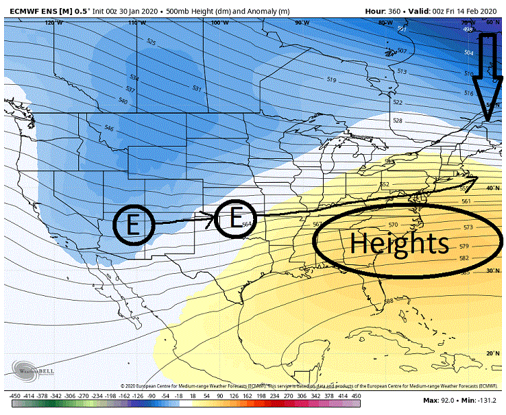
As has been noted by others on the board it looks as if we will have a gradient pattern setup in the extended. That is if the models can be trusted. If this is the case there are a couple of things I will be watching for. Below we have the Euro day 10/11 500's. Couple of things I want to point out. Note that we are seeing the greatest height builds running from the south and up the east coast. Consequently we are seeing the height lines in the east running up hill in response. Not really what we would want to see as it is pretty much a look that suggests that any energy running the boundary will run to our west and north. And short of seeing the boundary forced way to our south to offset its inevitable push northward with any system this is a look that will probably not work . And currently that doesn't look to be the case as to where the boundary will be far to the south. But look what we are seeing day 14/15 on the EPS. Note that the height builds are situated more to the south then the previous example where they were running up the coast thus we are seeing the heights lines running flat through the east (optimal look is to see the height lines running slightly down hill through the east). The reason we are seeing these differences in the heights is because we are seeing a stronger push of the PV towards the 50/50 region. This is a more forgiving look then the previous as it allows for the energy to run more W to E then SW to NE on the previous so we shouldn't see a major push northward of the boundary with any incoming system. This is a look you can potentially do well in if you can get the boundary underneath you by 100 maybe even 50 miles on an incoming system. *Now there is one word of caution I will throw in here. If you note that the greater neg anomalies are located up in southern Canada. I would prefer to see them farther south into NY or even into PA as they signify deeper, colder air. As is they are possibly suggesting that we might run into issues with the temp profile of the atmosphere even if we can get the boundary south of the region. But given the time of the year that may not be so much an issue.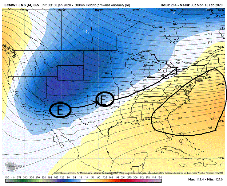
-
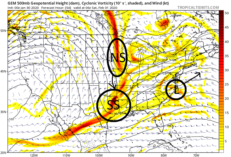
Mid January/Mid February Medium/Long Range Discussion
showmethesnow replied to WinterWxLuvr's topic in Mid Atlantic
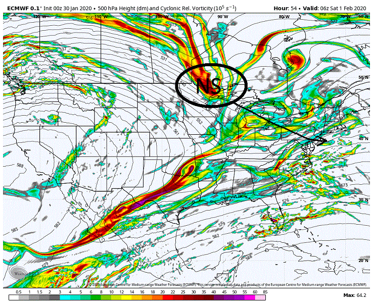
Okay, I think I have all but officially thrown in the towel as far as this weekends system. Have known for awhile it was a long shot but I held out hope for a surprise. At this point I think the best that can be hoped for is some White Rain with good rates for those that have good elevation to the N and W of the cities. The reason for good rates is to hopefully offset the deep warm layer we will see from just under 850 mb down to the surface. But even that possibility is all but gone as guidance has generally pulled the moisture southward run over run as to where even the cities may see no precip at all. Sort of expect a last second bump up with the system but no where near what we would need to see to get the rates. There is one last possibility here and that has to deal with when the 500's pull through after the system has already departed. And even that is quickly disappearing as well. What intrigued me about this period of time was how the models were handling the NS energy that was trailing the SS energy/coastal. As you can see from 2 days ago on the Euro we were seeing a deep drop in a prime location for possibilities on the East Coast. And we were seeing this at times on both the CMC and the GFS as well. The only problem with this look was the timing between the NS drop and the SS energy/low which is around OBX. But slow the SS energy down 12 hours as to where it is still in the deep south we are then looking at the possibility of a phase. Conversely speed up that SS energy by 12 hours as to where we see the low OTS this would allow height builds in front of the dropping NS energy to allow the trough it is embedded in to turn towards a neutral/negative tilt as it pushed into the east where any SS energy could potentially be picked up for a secondary low to pop. These things could also be accomplished with a slower or quicker drop of the NS as it is all about the separation between these two features. All that said above it really doesn't matter at this point. Because this is what we are now seeing on both the GFS and the Euro. This just will not get it done. Not only that but it even pretty much takes any possibilities away for when the 500's push through as the NS energy runs to our north through PA. But for those that are still holding out hope I offer you this. We are still seeing a deep drop of the NS on the CMC. We are also seeing a somewhat sloppy phase with SS energy as the NS is just a little to slow on this run. But we are still running into the same issues with the distance between the phase and the original coastal as they are still too close to allow good height builds off the coast to turn the trough. That said it is a close thing as we do see the trough attaining a neutral tilt as it runs through the east with a secondary low development off the coast that runs OTS. But speed up that original coastal by maybe 6 hours or so (or slow down the phase) and there are possibilities. And the CMC has been wishy washy with that low placement the last couple of days. So I guess there is still a chance though if I were a betting man I wouldn't be putting any money on it without some great odds.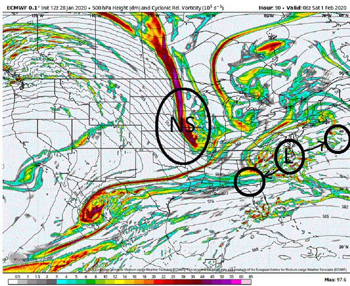
-
Mid January/Mid February Medium/Long Range Discussion
showmethesnow replied to WinterWxLuvr's topic in Mid Atlantic
You catch on quick. Decreasing the separation between the two isn't looking promising at this time. But with generally seeing an ever increasing deeper dig on recent runs with the NS this is allowing for more separation between the SS and NS which puts redevelopment on the table. So in other words, less separation and we have the possibility of a phase. More seperation and we have the chance of redevelopment. But of course we are stuck in the middle. eta: ninja'd by PSU -
Coming in here now-a-days it is like coming to watch a...

-
Mid January/Mid February Medium/Long Range Discussion
showmethesnow replied to WinterWxLuvr's topic in Mid Atlantic
Agree with you. I think the initial scenario is pretty much on life support at this time if not DOA. Just too much separation between the SS and NS at this time. But option B is starting to gain some steam with a secondary development. Still a lot of work to do with that though. Probably need more separation between the initial low and the dropping 500's. We need to see some energy left behind. And we need to see the trough, at worst, neutral as it enters the east. Otherwise a positively tilted/progressive trough will just shunt any secondary straight out to sea. -
Mid January/Mid February Medium/Long Range Discussion
showmethesnow replied to WinterWxLuvr's topic in Mid Atlantic
Been keeping an eye out for this possibility as well. Really will depend on what we see with the initial coastal. Wouldn't hurt to see the trough at least nuetral as it enters the east as well.


