

showmethesnow
-
Posts
7,250 -
Joined
-
Last visited
Content Type
Profiles
Blogs
Forums
American Weather
Media Demo
Store
Gallery
Everything posted by showmethesnow
-
Can we please keep the Climate Change Debate in the appropriate location? https://www.americanwx.com/bb/forum/18-climate-change/
-
Been hunting for tickets for one of his shows but I haven't had much luck so far.
-
Yes I am going to be that guy. NAM doesn't look too hateful leading into Saturday night. But enough of Fantasy and back to reality. GFS still looks pretty much dead in the water.
-
That SW had a good look days ago that showed promise but it continues to degrade as we near in time. Still have 3 1/2-4 days to get things right so I guess we will see.
-
You better hope the EPS is more right then the GEFS. GEFS was ugly. EPS doesn't look so great either as of right now it probably argues for the boundary to mostly be north of us.
-
I hope my 5:59 am posting met your needs. As currently depicted on both the GFS and the Euro there really isn't much upside to possible snow. Even if we would end up with the separation we would need the farther N track of the SW and very little dig probably argues for 1-2 inches at best. Still time to see the changes we need but I am not overly optimistic at this point.
-

The Seasonal Snowfall Futility Markers
showmethesnow replied to North Balti Zen's topic in Mid Atlantic
What's being provided? Brunch or Continental Breakfast? -
Quick glance on the Euro/Eps shows the same problem that we are seeing on the GFS. The separation between the NS and the SW moving eastward has decreased as well. This look is pretty much becoming one of the SW and the low washing out before it can even impact our region.
-
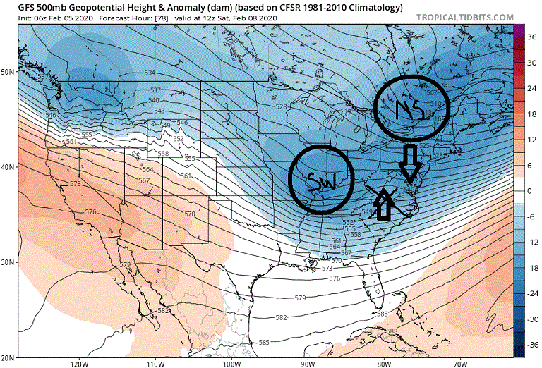
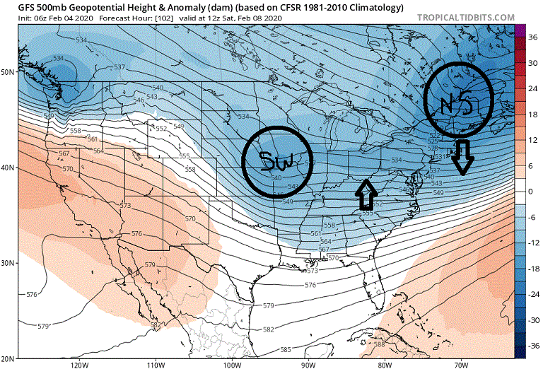
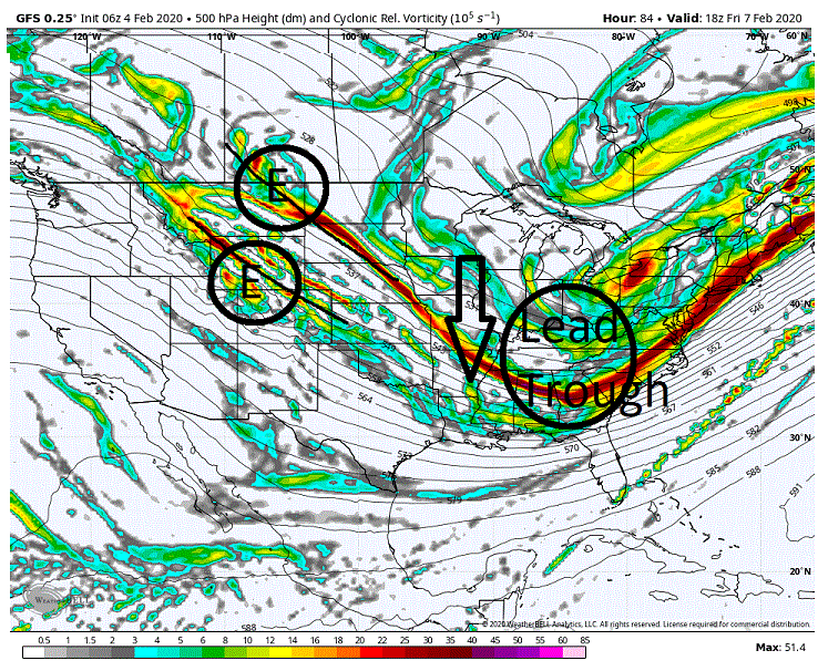
Haven't looked at the Euro/Eps as of yet so I won't speak for that but the 00Z GFS/GEFS and now the 06Z are running rough the last couple of runs for our chances for Sat night/Sun. And it is a pretty straight forward problem. First pic below is from yesterday's 06Z run which was one of the better solutions throw out there on the GFS. The important players here are the SW moving east and the NS shortwave moving through NE. Now compare that to their location on the second second pic which is this mornings run. Notice that the distance between both has dramatically decreased as both the NS is lagging behind and the SW moving east has speeded up. What is happening here is that the NS is pressing down on the flow in the east not allowing the heights in front of the incoming SW to recover. So basically the SW is getting washed out as well as is it's associated surface low pressure. Not a winning look for anything more then a stray flake or two if the temps even cooperate. We really need more separation between these two features to allow for some height builds. But it isn't even quite as simple as that. Too much separation could pooch us over as well. The flow that the eastward moving SW is embedded in is farther to the north then we would like it (thus the SW's track as well). So if we see too much separation between these two features we probably see greater height builds, thus a more supportive 500s for a stronger low. A stronger low will tend to pull farther north drawing the warm air in front of it potentially wrecking the temp profile through the region.
-
Winter 2019-2020 Digital Snow Thread
showmethesnow replied to NorthArlington101's topic in Mid Atlantic
Actually didn't mind the look on the EPS through that time period. Sure beat what the GEFS was advertising (pretty rough look) at 00Z. The look steadily improved from day 10 moving to 15. Pretty much a gradient pattern setting up with the boundary initially to our north (day 10) pushing southward of our region by day 15. Lower level temps (warm layers, surface) might be an issue for those just just north of the boundary but for those 50+ miles north at any given time I would think there would be decent potential. -
Think I have hit desperation mode. Op run where 90% of the snow comes after 12+ days, on the GFS no less, and yet I am all in. Let's reel this sucker in.
-
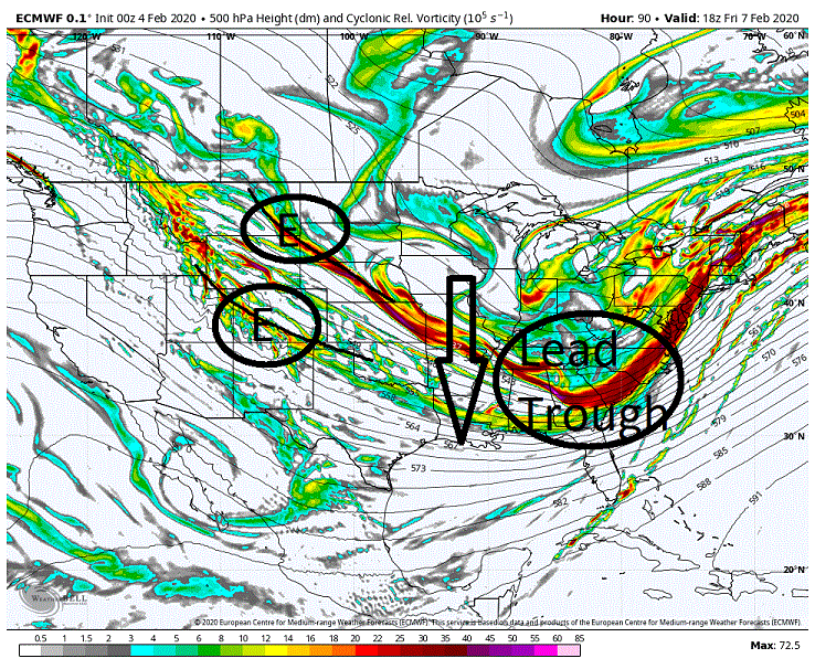
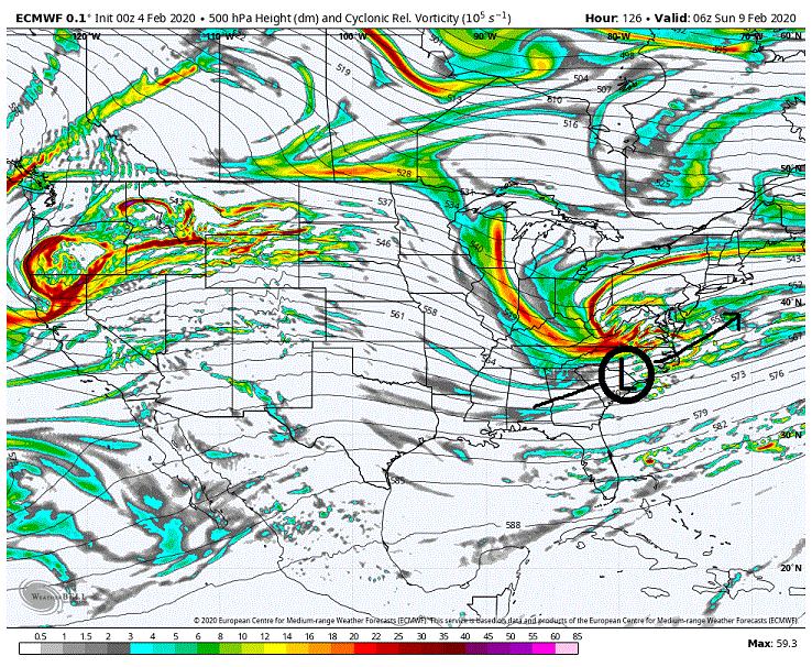
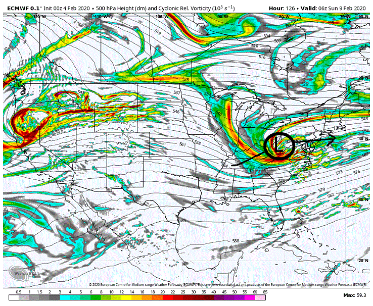
There was a lot to like with the latest Euro run for our Sunday system compared to the GFS as well as the last few runs of the Euro as well. What we are seeing is energy dropping down from the Pacific NW with one stream to the north as well as another stream under cutting it. The northern stream is dropping into the southern portion in the middle of the country and then moving eastward picking up surface low pressure and driving it into the east. Now where and when we see the phasing between these streams will be important for where we see the track of the storm as well as rain/mix/snow for our region. Now if we do a comparison between the current Euro and the GFS (previous Euros were similar) the difference maker is how far south the flow they are embedded in can drop south behind the lead trough. If you compare both models you will see that the Euro drops substantially farther south then what we are seeing on the GFS. This is important as this farther south solution would favor seeing low pressure development and track farther to the south in a more favorable position for us in the east. Now what is causing this more suppressed flow in the west/central portion of the CONUS is what we see occur with the leading trough in the east. What we saw on the latest Euro is that we saw a more significant initial drop of that feature through Texas and the Gulf states which dragged the flow farther south on it's backside. Moving forward a day and a half we can see the results. Directly below we have the GFS and we see that the shortwave/energy has picked up the forming low in the Tennessee valley and driven it into West Virginia. It then tracks it through our region and off the coast. Not a great look for us as it would tend to drive warm air through our region as the low moves to our west. Another thing I want to add is that we are also seeing a quicker phasing of those two streams on the GFS. This quicker phasing is also allowing for the 500's to attract the surface low quicker (In fact the low is captured over WV at this time) pulling the forming low northward as well. So between the farther north initial low development and the subsequent capture we are seeing a much farther north solution then what we see on the second map below the EPS. (***Now the look below is very perilous despite what may be showing up on the snow maps. The only saving grace is it washes out the low after capture so the southerly flow gets weakened. There are so many ways that this look could go wrong vs. right that I would not feel comfortable with our chances for anything somewhat meaningful if this is what we see at showtime.) But look at what we are seeing on the Euro. We are seeing the low forming in the deep south and then moving through OBX and then OTS. Now this look is a good one for our region, in particularly for our southern regions where the heavier precip will be confined, if only the temps can cooperate. One other thing I will note. Look at how we are seeing the energy curling and its location and where we see the low pressure. That is a very favorable look with just some minor adjustments to potentially capture the surface low in a favorable locale for strengthening it and drawing it up the coast somewhat to get the northern portions of the region into the better precip total. This is the look I hope to see as there is some good upside potential with no where near the perils presented on the GFS.
-
Mid January/Mid February Medium/Long Range Discussion
showmethesnow replied to WinterWxLuvr's topic in Mid Atlantic
Any other winter I would be very interested in the projected follow up low that comes through on Friday. Not so much this winter though. Prevailing theme through much of the winter seems to be to adjust the 500's westward (thus the track of the storms) as we near in time. But that said, I did notice on our last system (over the weekend) that the NS was quicker then projected inside 24-48 hours and that is what we probably would like to see here to hopefully help drag the boundary farther SEward for this possible system. Might be worth keeping an eye on the lead low that goes into the lakes. We start seeing that adjust towards the east might be a good sign as far as a farther SE placed boundary. One other thing I have noted is that we went from low pressure to the N and W of this system 2 days ago to where we are now seeing weak high pressure over top. Right now it is too weak and displaced too far north to be much, if any, of a player but let's see where we go with that. -
Mid January/Mid February Medium/Long Range Discussion
showmethesnow replied to WinterWxLuvr's topic in Mid Atlantic

-
My wife asked me the other day why I haven't been discussing snow this winter and talking up the possibilities of storms like I normally do. And I just cried.
-
Iv'e been there. When we first got married my wife would hear mention of snow in the forecast and then ask me if it will snow or not and how much. Of course that meant me explaining the different scenarios and the whys behind those scenarios. Of course her eyes quickly glazed over only to snap back to attention at the end to ask me once again whether we were getting snow and how much. So now I just say yes or no and how much. Unless I am feeling peevish then I go into the old routine with the added bonus of drawing up diagrams for her.
-
Mid January/Mid February Medium/Long Range Discussion
showmethesnow replied to WinterWxLuvr's topic in Mid Atlantic
Pretty much given up on that. Get a day of two of better looks/trends in that direction and yet inevitably it slides backwards. Has happened pretty much every time. Been one of the more frustrating winters in that regards because it wouldn't really take much in the way of shifting that PAC ridging eastward to get a somewhat half decent setup despite no N Atl help. Whatever. Think I am going to do what others have been discussing and travel to the snow. That is if I can get a decent storm to time up around the weekend in a local that is within 3-4 hours driving distance. -
Still showing up on the 06Z 3K though it is a little weaker. 12K has pulled the action a little farther northward up to around the MD/PA line.
-
Seeing some squalls running just N of the MD line in PA as well as some weaker returns to the west of Frederick but they are pretty much dying out as I post. Healthier returns are basically confined into central PA. Saw a stray flake or two here in Hanover but that was pretty much it.
-
Glancing over things and I will call it now. Bust on my part for this evening. Precip moved in several hours sooner then projected so we didn't get the benefit of the additional cooling we would have seen in the lower levels with a later start. Kind of thinking that may have not made much of a difference anyway. Still looks possible for a late night squall or two with the NS drop which would favor around the PA line. Nams are starting to really pick up on the idea of a squall line pushing through the region in the early afternoon as we see a secondary drop of NS energy down the backside of the trough.
-
-
Currently sitting at 38 degrees and looks as if there might be a little bit of white rain mixing in with the light rain.
-
Currently sitting just under 40 degrees. Have had light sprinkles for the last hour or so that have flipped over to a light rain in the last 15 minutes or so. Looking at radar and we are seeing a more robust precip field moving in then what the NAM's were projecting.
-
Latest NAMs are in. 12K is coming in with a drier solution whereas the 3K is wetter. Also seeing a shifting south of the main strip of precip on both. As I said in my morning post latitude would play a part in this as well and this shifting south is taking out somewhat the more favorable locations to see any meaningful snow (N and W of the cities) out of the equation. This is due to a combination of lower elevations on average to the south as well as the more favorable soundings being farther north. All that said I do think with what is generally depicted that there would be a good chance some would see snow mixed in with some of the heavier rates especially with those that have a little elevation. Now we have seen the shifting back and forth on placement and precip over the last day when the models first began picking this up so I am not so sure I would buy whole heartedly in to what the NAMs are currently throwing out at this time. This might be a case of looking at radar and temps as it is moving in to get an idea of what to actually expect. As far as my prediction above... Probably looking at mostly rain through the cities with snow mixing in with the heavier bursts. Just N and W of the cities I can see a mulch covering. And for the farther NW crew who also enjoy some elevation I can see a legit coating to an inch. Now those in the general jackpot areas are to be favored of course. I will throw one thing out there as well. I can see the possibility of a there being a very localized jackpot or two of 1-2 maybe even 3 inches if the stars align and we see some syncing with the different packets of energy within the atmosphere. And again those jackpots would more then likely favor those that enjoy some good elevation... Maybe (probably) I am being foolish but I will stick to it despite what has been a general degradation I am now seeing on the NAMs since the 00Z suite. There are several reasons for this but it is mostly because I am stubborn and hard headed (my wife can verify this) and I hate flip flopping like a fish on my calls after every run. And more importantly I checked my Ouiga Board and it says snow. If I bust hard then so be it.
-
Watched the lead in to that storm for about a week on the Weather Channel. Came oh so close to buying plane tickets back to visit my mother in Catonsville. But work and the thought of spending big bucks on last minute plane tickets stopped me. In hindsight I wish I had. The dynamics of the storm is very likely a once in a lifetime event. One thing that disappointed me though was seeing a good chunk of the DC/Balt metro turn over to ice for an extended period of time. Think about the only other storm that I missed that comes close on regret is the 82 storm when I was in college down at Georgia Tech.


