showmethesnow
-
Posts
7,250 -
Joined
-
Last visited
Content Type
Profiles
Blogs
Forums
American Weather
Media Demo
Store
Gallery
Everything posted by showmethesnow
-
Snow shovel looks as if it has hardly been used.
-
Liked a couple of things I saw but I am still Meh about the over all look that would probably favor something cutting to our west. Indiv ensemble members for the most part look like they support that idea (cutting west) though there are a few with somewhat suppressed solutions to the south.
-
Oh crap, I guess I have fallen to your level. That was the excuse I was just about to post. eta: Sorry, from reading all the comments I momentarily confused this with the banter thread.
-
I fully expect that we are going to see a lot of different solutions pop up on the models over the coming days. Just the nature of the beast with the features in play where different timing will mean a world of difference with solutions. Come Tue/Wed is when I will start taking the models somewhat seriously, until then I am just along for the ride.
-
GFS wasn't far from a good if not very good solution. Speed that NS energy up just a little that is running just in front of the SW and we see that storm bump north somewhat for a decent event. Take out the trailing shortwave or have it lag farther behind and you have the potential for a coastal going to town in a good locale for our region.
-
Basically seeing the shortwave that the storm will key on being washed out/squashed as it moves east. Two things are causing this. The NS energy is running just in front of the SW and we have another SW running right behind our initial SW.
-
I've been burned with that statement several times over the years. I myself see how we can easily Fail with suppression if the general look presented with the GEFS/GFS is somewhat right. Get one of those pieces of energy rotating around the pv to ride just in front of the Southwest energy as it moves eastward and we are going to see it squashed/suppressed to our south potentially quite a bit depending on the timing and how far south that pv drops.
-
Want to say once or twice in Nov/Dec but I could be wrong. Not counting on it because it is hard to discount the Euro. But the fact the Canadian is buying into it somewhat gives some hope.
-
You better hope that the GFS at least has the right idea about the PV drop otherwise I don't think it will make much difference what we see in the mid-latitudes.
-
Wouldn't even want to hazard a guess. But if you forced me, one that doesn't produce any snow for us?
-
Need to do that as well. Always hated waiting for hours down there but DMV is a lot easier to handle up here in PA. Go to Gettysburg and am normally out in a half an hour or so.
-
Looking at the models I might have to take a trip to Gettysburg today. For a Valentines gift for my wife of course. Has nothing to do with them showing the possibility of 2+ inches of snow there and me pretty much being fringed.
-
And let the games begin (for next Friday). 06Z gfs ejects the SW energy too quickly and it is getting squashed/sheered out by the first piece of energy rotating around the pv.
-
Meant to say this yesterday and got side tracked with tracking all the snow we are getting. Sounds like there might be quite a bit of rehab for your sister so I hope things go well. If there is a bright side, things could have been much worse so thank God they weren't. Thoughts are with you both.
-
Saw his post and I was like...
-
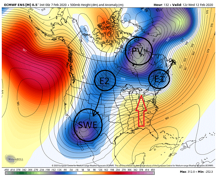
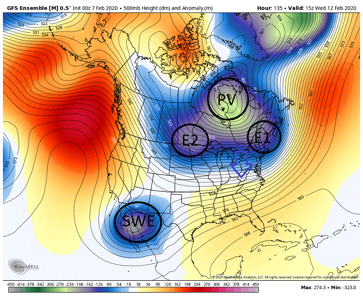
Saw some teases for a potential Big Dog showing up for around the Friday time period. After looking over the overnight GEFS and the EPS I would probably put that on the back burner for the time being. To get a Big Dog so much has to go right with several features and good timing, that is to say if all the features actually exist, that at 6/7 days it is asking a lot of the models. That said I think the odds aren't too bad for a 2/4, 3/6 type of event IF we actually see a further south drop of the PV in the general Hudson Bay region as the GEFS has. EPS doesn't have this and the GEPS is a compromise between the two. Below we have the EPS. It has the features in place, 2 pieces of energy rotating around the PV and energy ejecting out of the SW. But it has 2 fatal flaws. The PV is too far north and the second piece of energy is dropping down into the SW strengthening it. The result of these two things is pretty much a disaster of epic proportions (nod to @Ji ). What we see is stronger height builds in the east in response to the stronger trough in the west and any suppression that is being created by the PV and associated energy rotating around it is too far north to counter react it. Thus the energy/low in the south is ejecting too soon and shooting up to our west. But if we look at the GEFS we are seeing a farther south drop of the pv in a favorable locale, which is first thing we need to see, and we are also seeing the second piece of energy bypassing the SW trough and moving eastward. Long story short, this is creating the suppression we need. Now if it was only that simple for getting a Big Dog out of this look, but it is not. The timing of the ejection of the SW energy in relation to those two pieces of energy rotating around the pv is key as well. What we will see is a waxing and waning of the suppression created by these two pieces of energy (first piece of energy is setting the boundary for the 2nd) and that will be key as to whether we end up with a stronger system running up from the south/coast or a weaker system suppressed more to the south or anything in between. That is if we don't see the NS outrun the SWE and we end up with a cutter (barring a 3rd piece of energy rotating around reinforcing the suppression and/or initiating a coastal a couple days later). Really at this point being at 6/7 days all options are still pretty much on the table considering this will be all about timing, with a Big Dog pretty much low on the list of probabilities. Now knowing what is in play at this point on the models I probably wouldn't take any one solution to heart. This probably won't be somewhat resolved until we get inside 3 days and that may be rushing it. But if we can see a semblance of this look at that point I might start biting at the idea of a possible Big Dog. But at this time I will set my sights on a minor event and if we get it I will consider it a win.
-
The board reeks of desperation now. I think it is about harvest time.
-
But in my defense I was on massive amounts of drugs prescribed by my Snow Psychiatrist.
-

Dec-Mar 2019/20 NAO index predictor, -0.70
showmethesnow replied to UniversesBelowNormal's topic in Mid Atlantic
But you were wrong with gusto. That's the important thing. -

-
I swear this PV is like a punch drunk boxer. Been taking a beating all winter. And yet it get's up, staggers around for a bit and then is back, ready for the fight. Here's hoping that this might be an Ali upper cut being telegraphed to take its ass out. You know it is starting to get desperate when I start throwing out pv maps hoping for a miracle.
-
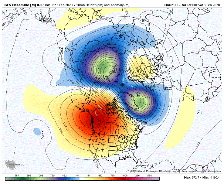
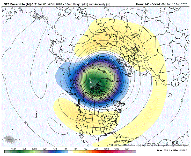
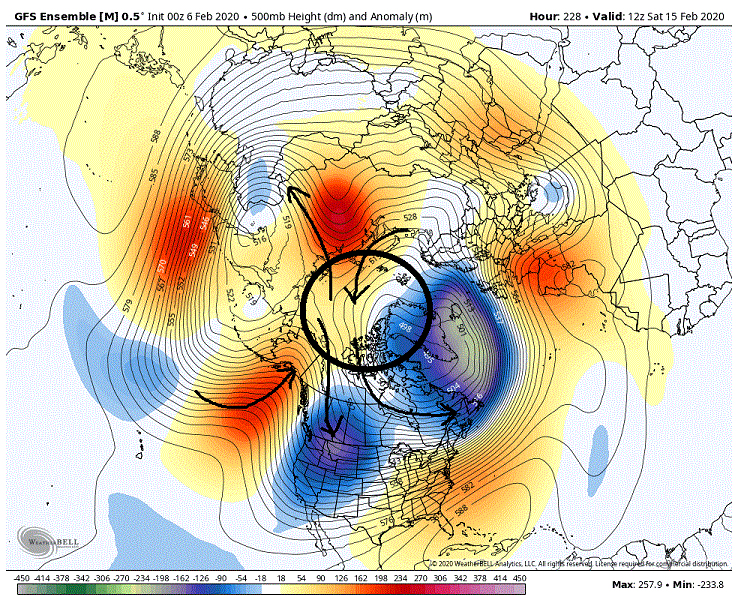
The simple answer to your question is, Air Flow. The PV tends to gravitate towards the pole as that is where its natural state is. The stronger the pv the stronger the attraction. But there are other forces in play as well that fight against this, trying to redistribute heat to balance out the extreme contrasts in temps from the arctic/ polar regions and the mid-latitudes. So what we normally see is a constant tug of war with the pv so that it quite often is displaced off the pole. Now where that pv is displaced to in relation to the pole is where your question comes into play. Below we have a map of the 500's. Now I want you to consider that black circle around the pole as a factory that produces ice. Now what this map shows is height lines. But I want you to consider it a fairly accurate read of what the air flow will be. So think of the air flow to and from that region as delivery services of ice to other locations as well as delivery of warm water to that ice box for future refreezing. You can see that delivers of ice are being made into the SW US as well southern and eastern Canada. We also see deliveries being made into eastern Russia around a weaker secondary pv. On the flip side we see warm water for freezing be shipped up through Alaska as well on the other side of the globe from eastern Europe and Russia. Now compare the second map to the first. Pretty spot on. So basically what it all comes down to is, where the pv is in relation to the pole and thus where the inflow and outflow from the polar/arctic region sets up.
-
The one thing I have learned is that these are two topics that better left off these boards. Seen some pretty nasty dustups over the years. Kind of ruins the enjoyment.
-
Not so much of a softening of the AO as much as more of a displacement southward of the PV towards Hudson Bay. That is one way I mentioned a while ago that I can see suppressing the flow in the east somewhat.
-
And now we are going to try to get a conversation started in politics? You are batting 2 for 2 today. It's bad enough that people are primed to go off with the crappy winter we have had but now you want to throw a.... Pretty much asking for...