

showmethesnow
-
Posts
7,250 -
Joined
-
Last visited
Content Type
Profiles
Blogs
Forums
American Weather
Media Demo
Store
Gallery
Everything posted by showmethesnow
-
Looking at the 500's that would probably run up the coast. Think that would be the final nail is the coffin for many of the remaining 's left standing. Get a nice NE'ster and it's rain. Of course we can always count on it producing its own cold air. That's a thing. Right?
-
Sigh.... We have seen this time and again over the last several years it is like a broken record (nod to another running joke). The EPS will just not give up on the idea of dumping too much energy into the West (day 9/10) of what could potential be a workable pattern setting up for us. Only saving grace is that it quickly ejects that energy as to where we are only losing 4/5 days before we can once again get a semblance of a workable pattern and cooperative temps. Of course by then we are seeing the higher heights up top quickly breaking down. GEFS on the other hand, though still a little too aggressive with the SW dump, is getting a better bypassing of the SW weakness by the NS allowing it to move eastward. This allows for a quicker bounce back (couple of days) into a workable look. GEPS is pretty much a compromise between the two, though it does feature a quicker recovery of temps/pattern such as the GEFS. Would be a shame really if it works out this way (too much energy dumped into the SW) because it throws a big monkey wrench into the developing pattern. Otherwise get the NS to mostly bypass the SW weakness and I think we would potentially see a somewhat sweet look setting up for us through the extended. Such is life. At this time I will be taking bets on which model is more right.
-
Looking online it looks as if it runs around $12 a bottle? So ask yourself, would that cheap SOB Snowme pay $12 a bottle? Sounds good, not sure I could find it up around here though. Might have to check.
-
I see the alcoholics are having their nightly AA meeting. Can I join? Sounds like fun.
-
Nope. Nothing.
-
Hope that measurement is in feet and not inches.
-
Most on here realize the futility we have gone through this year. We get it. So why state the obvious (being failure) on something posted that actually has somewhat of a positive spin? All this negativity gets old, hell it has been old for several years now. Just saying. Eta: you know, if you would have just added a reason to why the map was bs, any reasonable reason, then I would have been fine with it. But seeing as you didn't it becomes nothing more then just another post of the multitude we see these days that add no value except to add to the clutter and perpetuate the misery we see in here.
-
We are pretty much in, 'Wait and see mode' at this point. Anyway, got to run my puppy to the vet and then run some errands (Who knew Valentines day was today as my wife so subtly reminded me this morning.) Catch you later.
-
Digging the hole deeper and deeper I see. This will be filed with the rest of the paper work I will submit to the Reaper.
-
Saw a decent bump up of snow through the 16 days on the GEFS especially through VA. Interestingly enough it is now showing some interest on both the period that @C.A.P.E. morbidly was fascinated in (roughly day 6/7) and the period I mentioned above (roughly day 8/9).
-
Blasphemy! Heretic! Off with his head! eta: so I guess mine would be a NO vote.
-
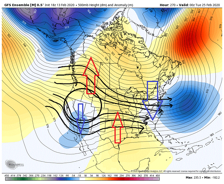
From my previous post: Now the models have been teasing back and forth with what they want to do as far as dumping energy in the SW. This just happened to be a run that went to the Dark Side. Who's to say that it won't flip right back come the 06Z run. So at this point I am not overly concerned. But if we start seeing this dump run after run on the various models.... ___________________________________________ And just like that we saw the 06Z GEFS flip back. As you can see we are now seeing run over run height builds in the west from the previous run. Circled region is the energy rotating down through the NS and for the most part it is bypassing the SW weakness. Hence we aren't seeing the height builds/ridging we saw on the previous run two maps below. Besides keeping an eye on the HL blocking this is probably the one other feature (NS dump vs no or partial dump) we really need to keep an eye. If we can get this right with decent blocking over-top as well. then the eastern PAC and the general wavelengths through the CONUS should fall in line. Doesn't necessarily guarantee snow but it would go a long way towards helping us to see it.
-
Hard to argue with persistence. And God knows this winter has been nothing but persistent, on screwing us that is. But I will remain optimistic until this gets nearer in time and/if it becomes glaringly obvious that this was just another Lucy pulled by the models. After all someone has to put on a cheery face with all the doom and gloom that has pervaded these boards this winter.
-
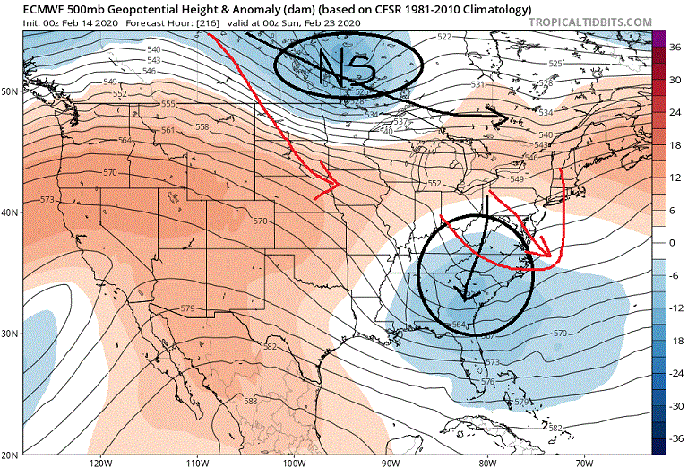
For some reason WB doesn't have the overnight Euro suite so I am limited on what I can see with Tropical tidbits up to 240 hr (not worth searching elsewhere for things that are happening in the extended). But there is one thing I would like to throw up. I know the other knowledgeable posters have been looking at a later time frame for the possibility of our snow chances to start increasing whereas I have been siding on the possibility of sooner scenario (day 8/9). I just want to show you why I am thinking maybe sooner. The overnight Euro actually was fairly close to a East Coast storm. Now if you look at the black lines this is what the run showed. A positively tilted trough running through our region with surface low pressure off the Florida and SE coasts. But note the NS energy dropping down through the northern lakes. This is basically pooching the possibilities. But lets look at the red lines. If we see that NS take a deeper drop what happens is it will help promote the turning of the trough. We would see the trough going negative tilt as it pulled through the region. The surface should respond accordingly pulling the surface low farther northward with a more northerly track. Now this isn't just a rogue run because we have seen the ensembles suggesting the possibilities for several days now. eta: Right now I would probably favor southern/coastal portions of our region vs. northern/western if anything were to possibly become of this. And of course we have to be mindful of temps as well.
-
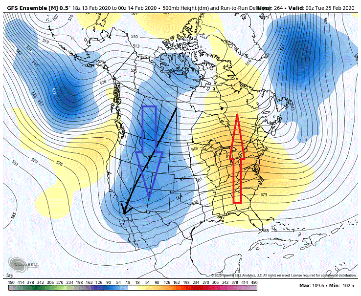
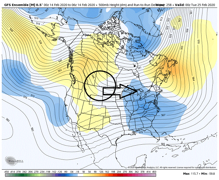
Overnight GEFS pretty much showed what we don't want to see as we move into our possible favorable period. Below are the run over run changes that we saw and you can see that it became aggressive with dumping energy into the SW. Thus we see the response of the ridging going to town in the east. Now for comparison sake here was the previous run. Here we see a split flow in the West (circle) creating basically a northern +PNA over-cutting a weakness (trough) in the SW. That's a good look for possibilities in the east. As you can see the SS dips in the west and we see it creating ridging to its east. But this ridging is muted and shifted to the west (good look for possibly pumping southern moisture into any developing system). The differences we are seeing with that ridging can be attributed to what we see with the NS. The NS in the below example is for the most part bypassing the SW weakness and moving eastward (follow the flow lines) creating push back to any ridging as it carves out the trough in the East. Now if you compare that to the above example we are seeing the NS (follow the flow lines) is more aggressive with the SW dump creating a full latitude trough. In response we are seeing full latitude ridging in the east. Now the first look just isn't a winning looking. It just isn't. Sure we could always luck into something. But it would be highly doubtful. Now we really need to see the NS for the most part bypass the SW. Otherwise we would be highly dependent on seeing very strong blocking up top to counter and push back against the desire for the pattern to pump up strong heights/ridging in the east. Now the models have been teasing back and forth with what they want to do as far as dumping energy in the SW. This just happened to be a run that went to the Dark Side. Who's to say that it won't flip right back come the 06Z run. So at this point I am not overly concerned. But if we start seeing this dump run after run on the various models....

-
Never really had much interest through that time period especially for MBY. Though I won't lie and say I haven't been keeping an eye on it and still will for the next few days. Little less suppression and you never know.
-
Yep, guess it's time to bale when an op run at 11 days shows something counter to what the ensembles have.
-
Kind of confused here. Models were showing our snow chances starting to increase roughly day 9/10 and onward. And after just looking over the GEFS and the EPS that doesn't look like that has really changed. So what are some people worried about? The system that comes before that time period?
-
I see it's been par for the course in here.
-
Describes my wife down to a tee.
-
First I really looked at the Euro besides some cursory glances. Normally don't dig deep on op runs at range. But yeah the Euro does eject it quicker as well but its evolution afterwards is different. It drives the energy into the deep south and initially shears the hell out of it before it is resurrected once again. Really, about the only thing I am keying on at this point is seeing the models throwing out the blocking over top and sprinkling closed lows throughout their runs. Not going to worry about details until we can get this period of time somewhat in range.
-
I really wouldn't want to extrapolate it because it is to close to call IMO. Probably just enough to know that it did show a possibility. Might very well be a mute point because I have my doubts we see that SW eject so quickly anyway.
-
This isn't really the period of time I have been focusing on. Still a little to early IMO. I am looking more so just beyond that period. Day 9/10 onward. Still sort of like that window I threw up yesterday which would be roughly Day 11-13 as of now.
-
GFS want's no part in ejecting that SW such as we see on the ICON. Still planted firmly in the deep SW with it just starting to get the inclination to move eastward at 180 hr.
-
LOL. Was just about to post. It's the ICON so take it for what it's worth. Ejecting the energy much quicker. The look has some promise though I wouldn't want to place bets if we could see that cutoff run under us. eta: Has a strong high in the west as well. 54 mb at one point?


