

showmethesnow
-
Posts
7,250 -
Joined
-
Last visited
Content Type
Profiles
Blogs
Forums
American Weather
Media Demo
Store
Gallery
Everything posted by showmethesnow
-
Have been keeping an eye on that as well. Temps will be an issue though and I am not sure how we can achieve the temps needed without killing the SW before it can have an impact on us.
-
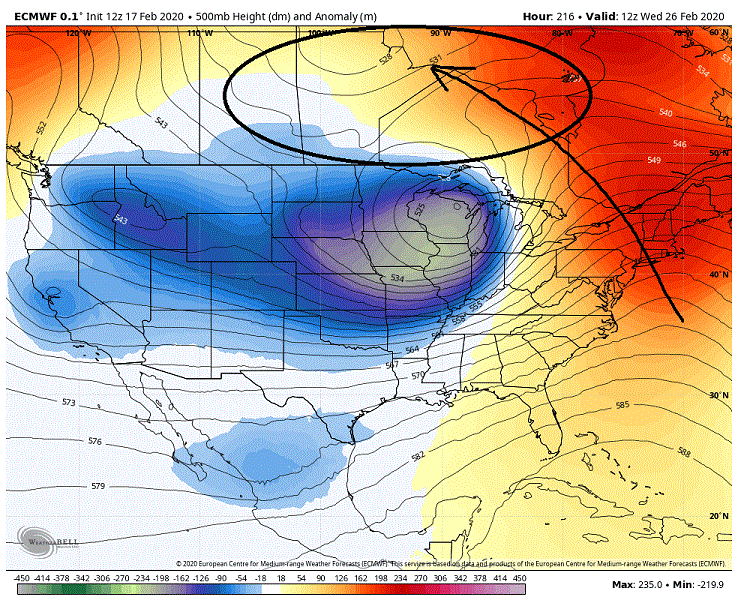
That's a pretty impressive look. Keep in mind that there is a lot of energy stored within that jet. When the SPV starts weakening and breaking down as we transition into Spring that energy will need to be released. How that will probably be released will be with some significant amplification within the mid-latitude wave lengths. There could be some very impressive/wacky solutions in store for us in the spring.
-
AND
-
But... but... but the NAM says there may be some hope. Especially for you.
-
Morning GFS was somewhat interesting. Slight shifting E of the initial SW dump (might only be noise) but what really stuck out was it now has NS energy showing up in eastern Canada that is helping to suppress the dump as it moves eastward. Not in such a favorable locale and it doesn't evolve the same as the Euro but none the less it does help shift the track southward.
-
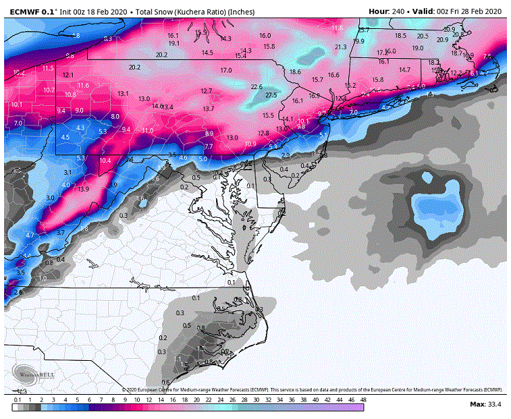
Haven't really been invested in the late Thur/Fri possibilities for the DC/Balt region let alone in MBY but I thought I would throw up something for those that are farther south and may have some interest in it. Now this is the overnight CMC. It is the best solution I see at this time with a good deal less suppression running interference then some of the other models. So keep that in mind with its more northerly solution. What we have is a northerly flow from 850 mbs down to the surface through the mid-Atlantic region funneling cold air southward. Now where we probably want to keep an eye on is what is happening above the 850s up through 700 mbs as this is where the the precip will be created. What I want you to note is the wind barb directions of the air flow we are seeing at 700 mbs. As you can see the wind barbs through S Va and N Carolina are from a SWesterly direction. This is funneling moisture over top of the colder air in place at the lower levels and where the cold is deep enough and cold enough we are seeing snow. But now look to the north through N Va and MD. We are seeing the winds from a W/NW direction which is bringing in dry air from the north and the west. So if you want to follow the upper levels to get an idea where the precip will be just draw a line where these wind barbs intersect and shift it a little northward it will give you a good idea where the northern extent of the precip will shut off. Now I haven't been high on this period of time for quite awhile and that really hasn't changed. But I will point out that if we were to see the suppression to our NE dampen down a fair bit with the same amount of dig we are currently seeing with the trailing SW the resulting look would actually be a good one for prospects up into MD. But as it is we are now talking under 3 days and it is probably asking to much to see the changes we need to see. But I have seen stranger things happen in less time so I guess you never know.
-
Quickly looking over the EPS and we have seen the EPS stepping away from the initial strong SW dump on the last 2 runs as well. Now the followup with the 500's is still tracking it to our north and west but that is of little consequence at this time. Just know that this change in the initial dump puts us in a far better position as the 500's progress eastward.
-
Here are the changes we saw within the Euro from 12z to 00z. ***The objective here is to get the 500s/cutoff low through or underneath our region*** Below is the 12z run and the initial dump is into the West. As it moves eastward it is encounter higher heights that were produced by that aggressive SW dump. For those who read my post awhile ago one way I mentioned to get a more southern track dealt with the ridging in front. If we could see a sharper hooking ridge with the higher height anomalies running over top the system this would be one way. As I also mentioned inserting a 50/50 into this setup might accomplish this. As you can see we have neither so this cutoff is shooting north. But this is the overnight run. Substantial differences across the board. We are now seeing the SW dump much farther to the East so we aren't seeing that strong ridging popping up in the east. If you also note we now have ridging in the west vs. the troughing/lower heights we see above. But the biggest difference maker here for the closed lows track (besides the obvious muting of the ridging in the east) is what we are seeing over top. We now have a SW running in front and over top this closed low suppressing the flow and the closed low along with it. This run came very close to a very satisfactory event for our region. Another 50/100 miles shift south... Now the latest run was pretty much an outlier from what I have seen on guidance for quite awhile now and it is an op run at range to boot. So I wouldn't get too invested in its solution at this time. ***If anything on this op run is to be right I hope it is with how it initially handles the dump. Get it much farther to the east into the central CONUS instead of the deep SW and it would be a much more forgiving pattern that would open up more options. And this might actually have some play (fingers crossed) as we saw the 12z back off on that as well from previous runs. Guess it's time to check the EPS to see if we are seeing changes there as well.
-
Wow. Euro almost gets it done day 8/9. See the SW dump drop much farther to the east as it follows the lead shortwaves track and now cuts through our region. This is the result. eta: The difference maker here is that we have seen a major change over top with energy in the NS now over riding the storm through southern Canada.
-
You know, maybe if I drink a 12 pack and I squint my eyes then look at it cross eyed I can see a possibility. No, no that isn't working. In all seriousness it is nice to see the SW flow that is produced by a little deeper dig instead of the westerly flow. Better able to get moisture to over flow the cold air in place. But we really need to see less suppression in front of that wave otherwise the moisture is going to only come so far north. eta: talking about the ICON, not that I particularly believe it.
-

-
See that is why you should move up to the favored locales to the North and West where you can score. 38-42 degree rainstorms is where it is at.
-
Just talking generally here and not about any particular run or of model but we have seen a general easing of the suppression over the last few days for the unsettled weather around day 4/5. Problem is it has been no where near what we need to have to see for possible impacts up through the Balt/DC region and I am not holding out much hope at this time. Maybe for you with the SE locale advantage it is worth a casual glance but up here? Nah, not so much. Funny thing is, if we were to see the needed backing off of the suppression I think it could be a nice little event as the setup would be more conducive for getting moisture thrown over the cold or even for a possible minor spin up. Think that is probably what we are seeing with the occasional good looking ensemble members though I haven't cared to check that for fact. 4 days so I guess you never know. eta: I assume you were referring to the follow up period and not the period just after the front clears?
-
Outside of possibly something for the far SE portions of the region early on I am pretty much Meh with any potential (aside from maybe a stray flake or two) until after we see that big western dump progress eastward. And anything, after that clears the area, is pretty much about waiting to see how that evolves over the next week. Guess maybe the shortwave running in front of that dump around day 8 is worth watching? But not sure how we get the cold air we need in place with out squashing and/or suppressing that shortwave. eta: That is if the leading shortwave can even make it to our region without getting absorbed by the trailing SW dump.
-
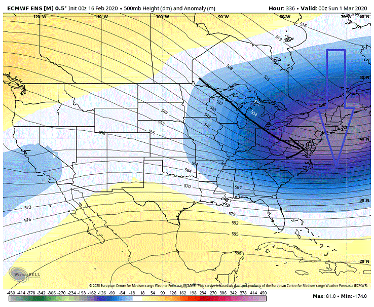
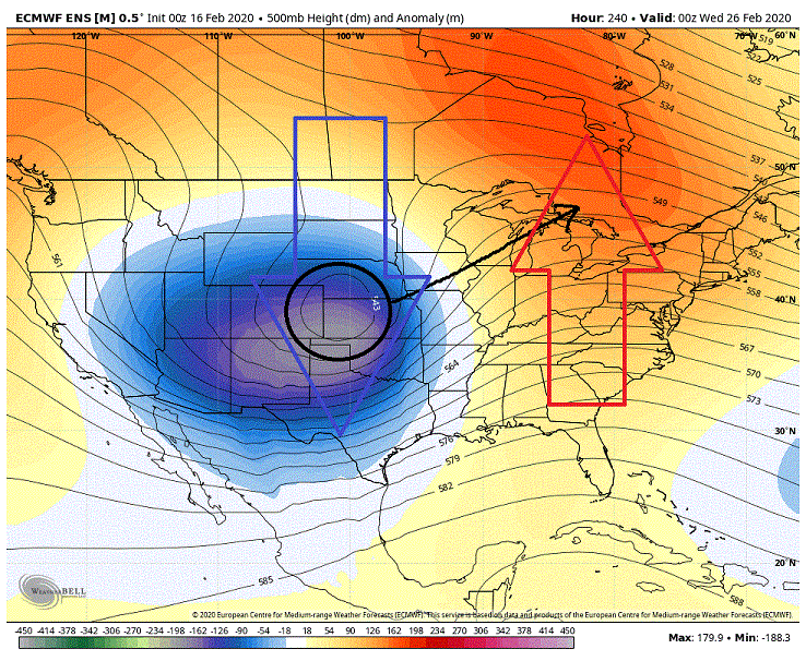
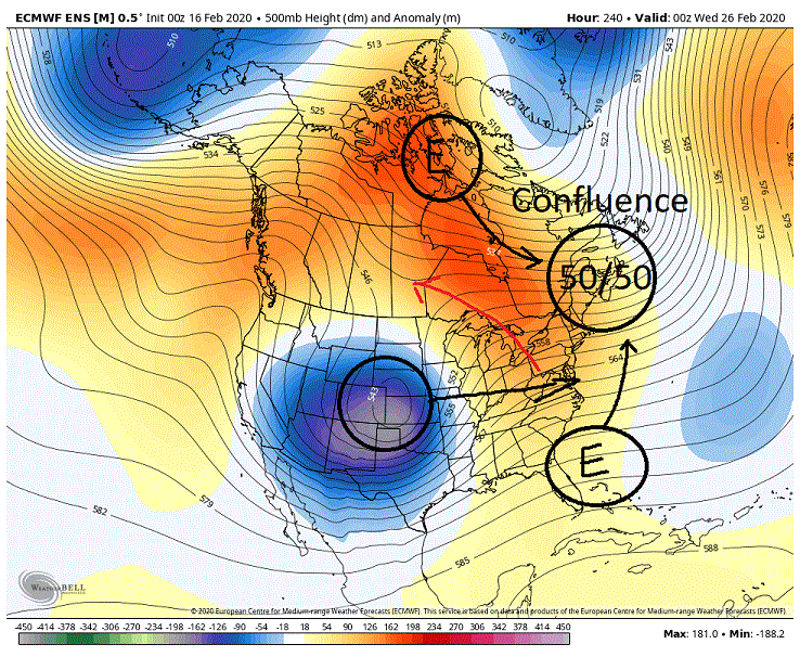
Wasn't particularly enthused with what I saw on the overnight runs as far as the extended. But 10+ days is a lot of time to work with so I will point out some possibilities. First off this is what we are currently looking at. Day 10 is a downright ugly look. We have seen a massive dump into the West and the heights in the East are going to town. Closed Low/500's are shooting up far to our N and W into southern Canada. I hope I don't have to explain why this isn't a snow look. Then by day 14 this is what the above has transitioned to. Again this isn't a good look for our snow chances outside of some pity snow. On the backside of the trough as the NW flow initially sets up running through the region. Besides maybe some flurries or even a potential snow squall for some lucky soul this will not sate the snow starved weenies. Even during the transition period (from the above to the below maps) things look rough. Now I said I would offer up some possibilities through the extended (day 10-16). First off lets look at day 10 as the cutoff moves eastward. The objective here is to get the cutoff to run through if not to our south instead of the Lakes. Pretty simple to do in theory but more difficult in practice. Just pop a 50/50 into place of which we quite often talk about. It would provide the confluence that we need in the NE to help force the cutoff southward. Separation between the 50/50 and the cutoff would be important though so we would be talking timing. The narrower the separation the greater the impact on forcing the cutoff low southward as it would sharpen the ridging and create a hooking of that ridge over-top of the cutoff helping to push back from it's tendency to pull pole ward. Now achieving the 50/50 is the hard part. I see two possible sources at this time. The unsettled weather off the SE coast is one. Right now it moves eastward off the coast and you can see that reflected by the lower height anomalies far OTS. But if we could actually see that pull northward up off the coast with a distinct system that could possibly provide the 50/50 we would need. Really, at this time that is a long shot. The setup being projected just doesn't favor this option. That leaves us with option number two, one that may actually have some play. Note the lobe of the PV off of SE Greenland. What we have is pieces of energy rotating around the backside down towards the 50/50 region. Now if we could get a stronger well timed piece that can blow up we now have the 50/50 we need. In fact the overnight Euro had this play out. The separation between it and the cutoff was probably still too great but if we would have projected beyond day 10 I think there was a strong chance we would have seen a decent adjustment southward of its track compared to what previous runs were suggesting. **Now the above scenario will be highly dependent on the 500's bringing sufficient cold with it for our snow chances*** Beyond day 14 as the flow begins to relax is probably our best chances for seeing snow. Several options pop up and that deals with any energy trailing in the different streams behind the relax. First off we have SS energy but that has been squashed deep into the south and short of seeing interaction between it and any possibly PAC energy that has low odds of coming into play. The second possibility deals with PAC energy. But any PAC energy would need fairly good timing with the withdrawing suppression. Too little separation and it probably gets squashed out of existence and too great of separation and we are back to something cutting to our west. ***Want to point out that we are basically in Fantasy land when it comes to when and where any energy may exist in the NS , if in fact there is any energy to speak of. So the below map is just to give you a general idea of what I am talking about*** Our best chances though probably deal with what we see within the NS. As you can see on the below map what we have is the initial push of the NS now withdrawing up into the 50/50 region and we see a secondary push/energy of the NS dropping down into the central US. Now this secondary push is important as it helping to keep the cold mostly planted to the south instead of withdrawing. Now if we don't see enough separation between the dropping energy and the suppression in the East at best we are probably looking at the possibility a quick hitting system (1-2 inches) as it will not have enough room to amplify. But if we can see enough separation between it and the initial NS push running through the 50/50 this would allow for the possibility of some amplification for a more modest event. Now of course the above will be highly contingent on what kind of drop we would see from any trailing NS energy. And at this time there is no possible way to guess. One last comment. I would really like to see option one above work out some how (Getting the closed low through or underneath us). As it is now the closed low is pushing northward breaking down the higher heights it helped create. Take that out of the equation and we are going to get a much different look moving forward. One that more then likely would be much more favorable for us.

-
I am thinking I should be offended.
-
Last I saw with the EPS it was broaching 7 with low amplitude and heading back into the COD. Problem though is it is dumping into the COD after traveling through the warm phases at a pretty good amplitude. Usually get a residual hangover from those phases.
-
That went into the tank fast. Last I saw a couple of days ago it was firmly into 8 with some decent amplitude.
-
Duly noted.
-
Nah, I am talking back in the early 70's, you youngster, you.
-
The best kind. Remember as a child down somewhere around Catonsville/Elliott City had a snow squall that has never been topped. Saw 5-6 inches in maybe 30-45 minutes. Didn't have thunder but we had snowflakes that were coming down almost the size of baseballs. Never seen the like since.
-
With 40's and rain in April as the -NAO sets up.
-
Not sure I wouldn't rule out some sustained stout blocking over top just yet. Kind of favor us seeing that occur, but the question is when and will it be time to catch the tail end of winter. Had some hopes we were starting to see it rear it's head in the extended but what we are seeing projected to occur in the west and what it means as we move forward in time is pretty much screwing that up.
-
Yeah, except for some brief periods the PAC has been all but predictable this year. And not in a good way.
-
Pretty much have given up on the idea of a sustained workable look for our region for when it counts (climo). But I was hoping against hope we could at least get a decent look for at least a brief window (5-7 days maybe a little more?) and just a few days ago the models were offering that up. But now the models are keying on dumping varying degrees of NS energy into the SW which is pretty much pooching that window I was seeing. Now towards the end of the extended we do progress to a look that is workable but will require more in the way of luck and timing then what we more have likely seen if the NS would have just bypassed the SW. Really think we had a shot at a somewhat sweet look in that case and a possible extended one at that if things broke right. Haven't given up hope yet on the models flipping in that regards (still at 9/10 days) but it is frustrating as hell watching where they are going with it at this time. Don't even want to bother speculating beyond the end of the extended because that has been nothing more then an exercise in futility this winter.


