Random Chaos
-
Posts
871 -
Joined
-
Last visited
Content Type
Profiles
Blogs
Forums
American Weather
Media Demo
Store
Gallery
Everything posted by Random Chaos
-
I decided to look at the EF damage scale for high rises for what we are seeing. While we don't have the negative pressure of a tornado (so thus roof damage isn't expected), some of the other damage level categories are likely valid. I am specifically looking at damage level category 8 "Significant damage to curtain walls and interior walls" for 20+ story high rises - some of the videos and pictures that have come out show entire portions of floors appearing wiped clean of walls. The wind range for a tornado to do significant wall damage is lower bound 123 to upper bound 172mph, with the average point that this damage appears at 145mph. Given that the hurricane was estimated 165mph at landfall, this damage level makes sense. Additionally, the high rise is likely to sustain more damage than ground level - winds are stronger 100+ feet above the ground than they are at the surface, and the 165mph was surface winds. We could have seen 185 to 200mph at the tops of some of these buildings. https://www.spc.noaa.gov/efscale/19.html
-
Location: https://maps.app.goo.gl/mB82uj4BEokmpnC37?g_st=ic
-
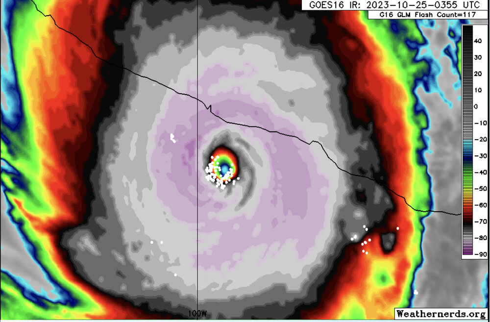
New update: 000 WTPZ63 KNHC 250459 TCUEP3 Hurricane Otis Tropical Cyclone Update NWS National Hurricane Center Miami FL EP182023 1200 AM CDT Wed Oct 25 2023 ...EYEWALL OF POTENTIALLY CATASTROPHIC CATEGORY 5 HURRICANE OTIS MOVING ASHORE NEAR ACAPULCO MEXICO... ...12 AM POSITION UPDATE... Satellite imagery indicates that the eyewall of potentially catastrophic Hurricane Otis is moving ashore the southern coast of Mexico near Acapulco. Maximum sustained winds are estimated to be 165 mph (270 km/h) with higher gusts. Otis is a category 5 hurricane on the Saffir-Simpson Hurricane Wind Scale. Otis is forecast to remain a category 5 hurricane through landfall within the next few hours. SUMMARY OF 1200 AM CDT...0500 UTC...INFORMATION ----------------------------------------------- LOCATION...16.5 99.7W ABOUT 30 MI...50 KM SSE OF ACAPULCO MEXICO MAXIMUM SUSTAINED WINDS...165 MPH...270 KM/H PRESENT MOVEMENT...NNW OR 345 DEGREES AT 9 MPH...15 KM/H MINIMUM CENTRAL PRESSURE...923 MB...27.26 INCHES
-
I’m thinking of some of the Central American Atlantic storms that have caused major mudslides with only a Cat 1 or Cat 2. The amount of rain this will drop is going to be bad. I’m not downplaying the wind, but the wind is often not the killer, it’s the flooding, mudslides, and storm surge (the later this storm has less risk with in part due to the short time between strengthening and landfall)
-
Also can’t forget flooding as the rain is squeezed out by the higher elevations.
-
Update from NHC; Hurricane Otis Tropical Cyclone Update NWS National Hurricane Center Miami FL EP182023 1100 PM CDT Tue Oct 24 2023 ...POTENTIALLY CATASTROPHIC CATEGORY 5 HURRICANE OTIS STILL STRENGTHENING AS IT NEARS THE COAST OF SOUTHERN MEXICO... Recent satellite data indicate that Otis continues to strengthen. The maximum sustained winds are now estimated to be near 165 mph (270 km/h) with higher gusts. Otis is a category 5 hurricane on the Saffir-Simpson Hurricane Wind Scale. Otis is forecast to remain a category 5 hurricane through landfall overnight.
-
Lightening in the eyewall is still firing off:
-
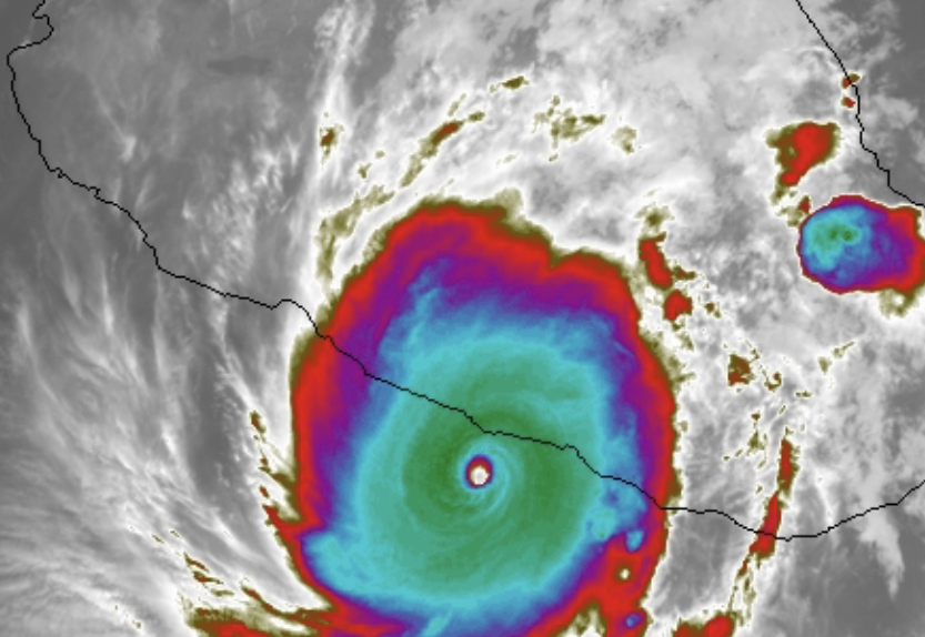
Incredible core on IR now. Really cleared out. Image from https://weather.ndc.nasa.gov/GOES/ using IR9 color scale.
-
Low overnight of 47.2. Quite a bit warmer than a lot of you.
-
 Just got to ignore that spin near La Plata and it definitely does
 -
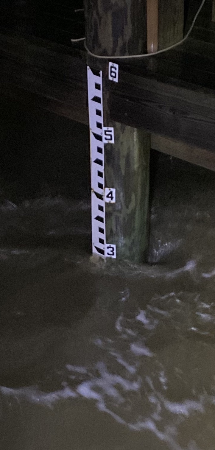
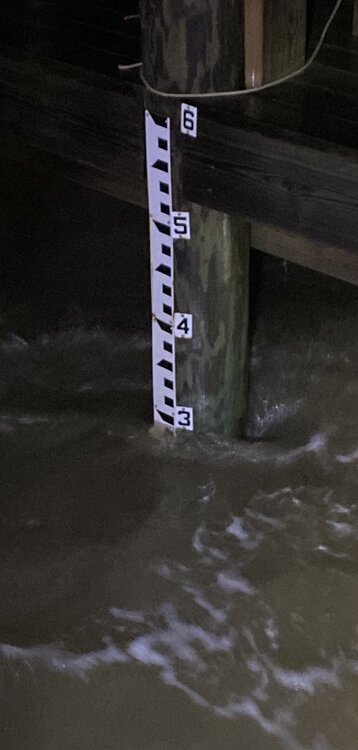
Staff gauge this morning (about 8:30am) in NAVD88 Datum: This beach normally has about 15 feed wide sand: And a neighbor sent me this from about a mile and a half from me:
-
Yeah GFS has been suggesting that the past day:
-
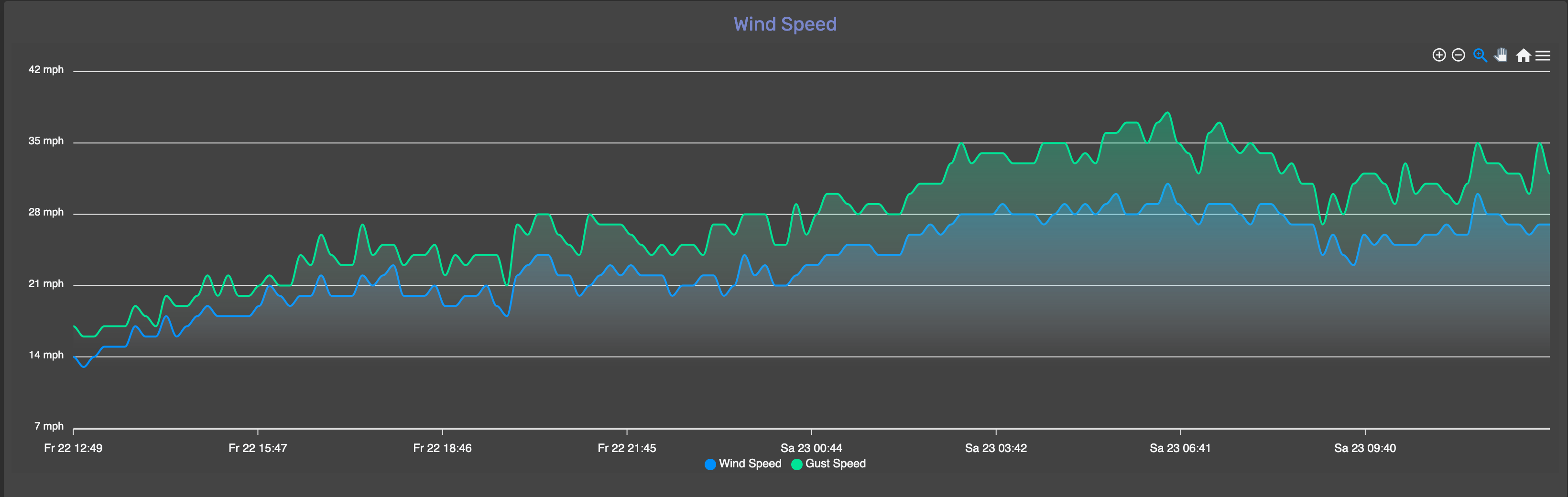
While it's still raining in some areas, here are initial rainfall estimates from https://mrms.nssl.noaa.gov/qvs/product_viewer/ And here's my anemometer output:
-
We are near peak tide (peak tide was estimated starting around 1am and lasting through about 3am). Measured based on NAVD88 Datum a tide height of 3.0'. Per Annapolis data, MLW is -0.55' vs Datum. This was average height with waves. Winds have dropped off, now 22-25mph gusts 25-28mph from the ENE (same direction they have been running the past several hours). Forecast was for the winds to hit slack near high tide as the wind directions shifts from NE to S as the circulation center moves through. You can see the modest drop off in wind speed here: This photo is of the staff gauge calibrated to NAVD88 Datum at a null in wave activity that lasted about 30 seconds.
-
Peak gust 39mph about an hour ago. 1.11" rain.
-
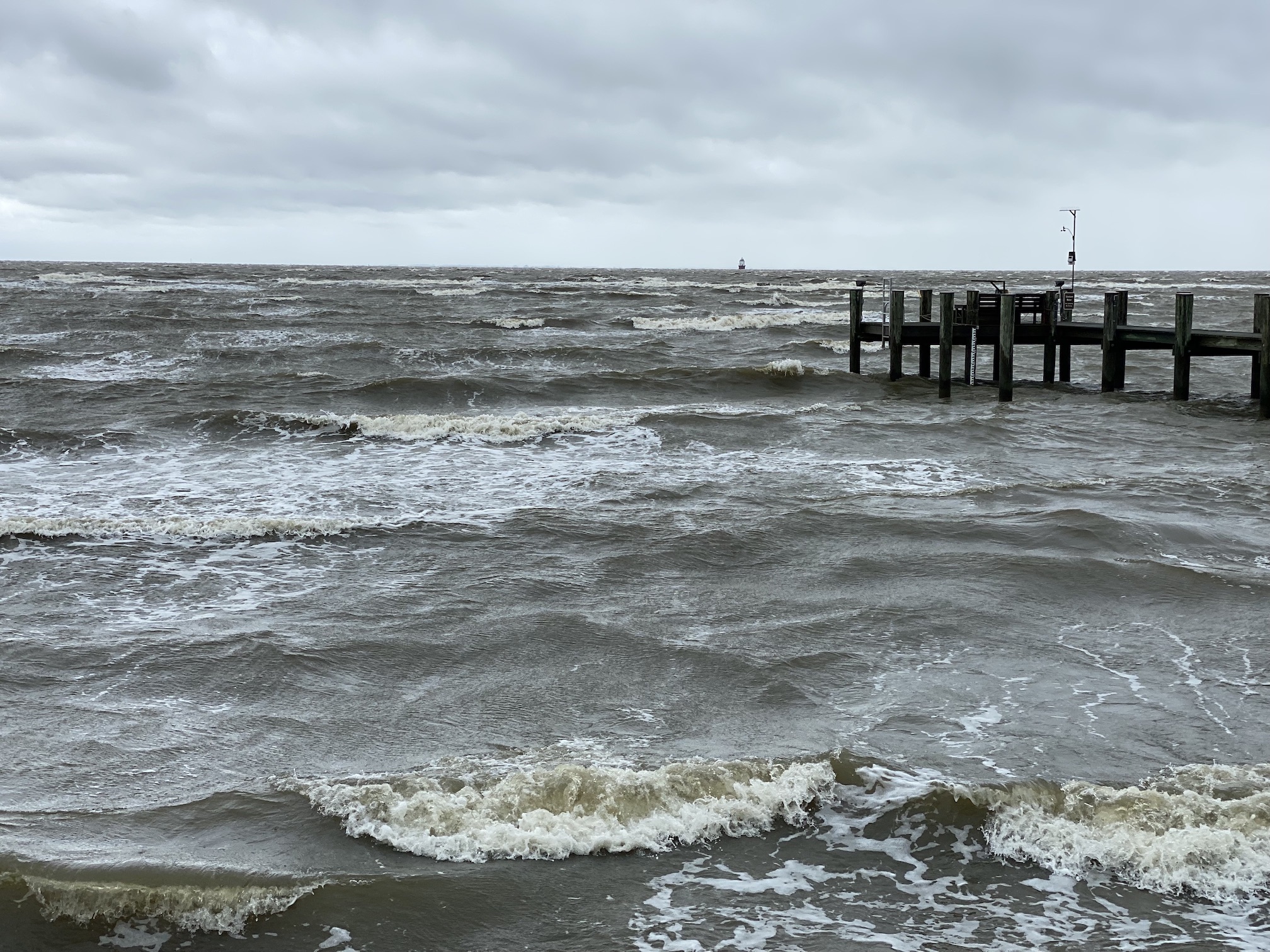
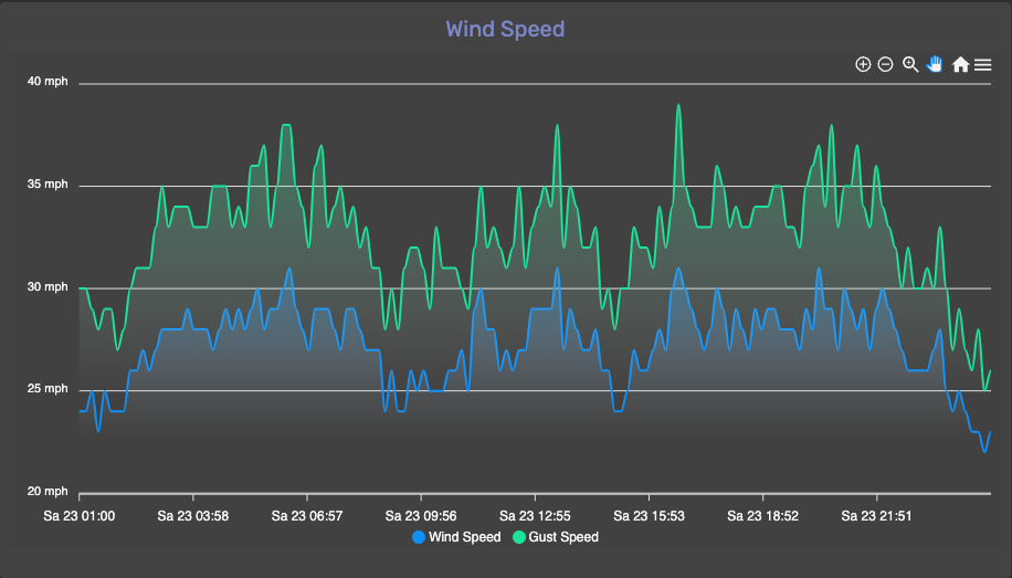
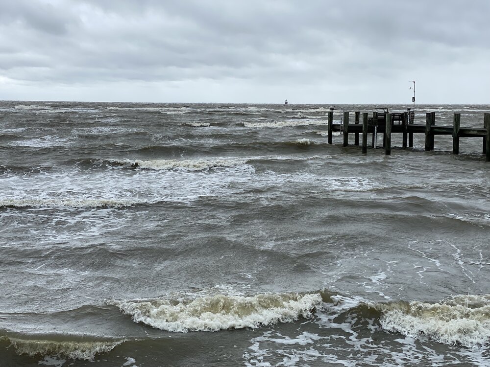
Wind so far (graph) and sea state. Photo has my anemometer in it on the pier. Tide is around 1' datum (0.5' MLW).

-
0.87" rain, nothing coming down right now. Tide about 0.5’ Datum (believe that is about 0.0’ MLW based on Annapolis being -0.55 datum to MLW). Winds are around 25 gusting 30. They peaked earlier today 30 gusting 38.
-
Just lost power. Winds 26-28 gusting 35.
-
Transition more likely the reason. Winds are forecast (just north of Bay Bridge): Tonight NE wind 19 to 24 kt, with gusts as high as 34 kt. Rain, mainly after 11pm. Seas 3 to 4 ft. Saturday NE wind around 30 kt, with gusts as high as 44 kt. Rain. Seas 5 to 6 ft. Saturday Night NE wind 27 to 32 kt decreasing to 17 to 22 kt. Winds could gust as high as 41 kt. Rain. Seas 6 ft subsiding to 3 ft. Though models actually show strongest winds tonight closer 30-35kt gusts 50kt+
-
Little surprised that there is not even a Tropical Storm Watch for the northern Chesapeake Bay. Most of the models are predicting 35-40mph-winds.
-
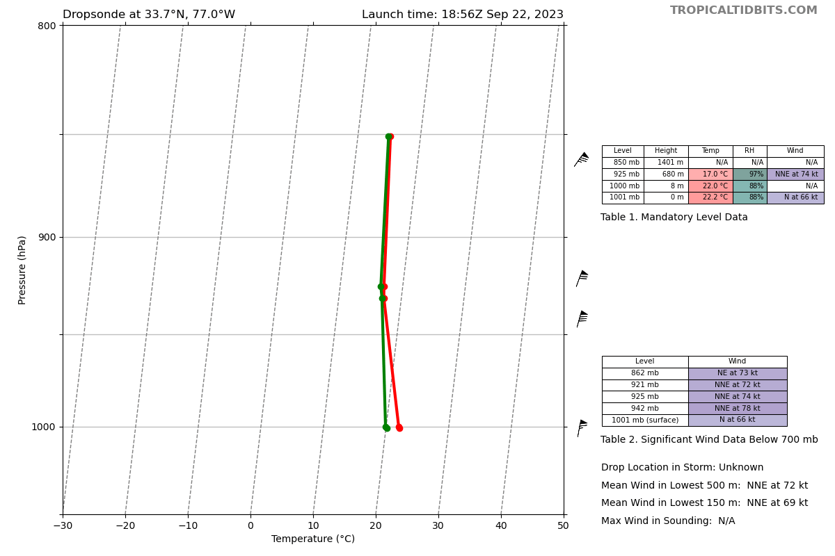
No, 925mb on what I posted was 74kt. Surface at 1001mb was 66kt.
-
And dropsonde with 66kt surface.
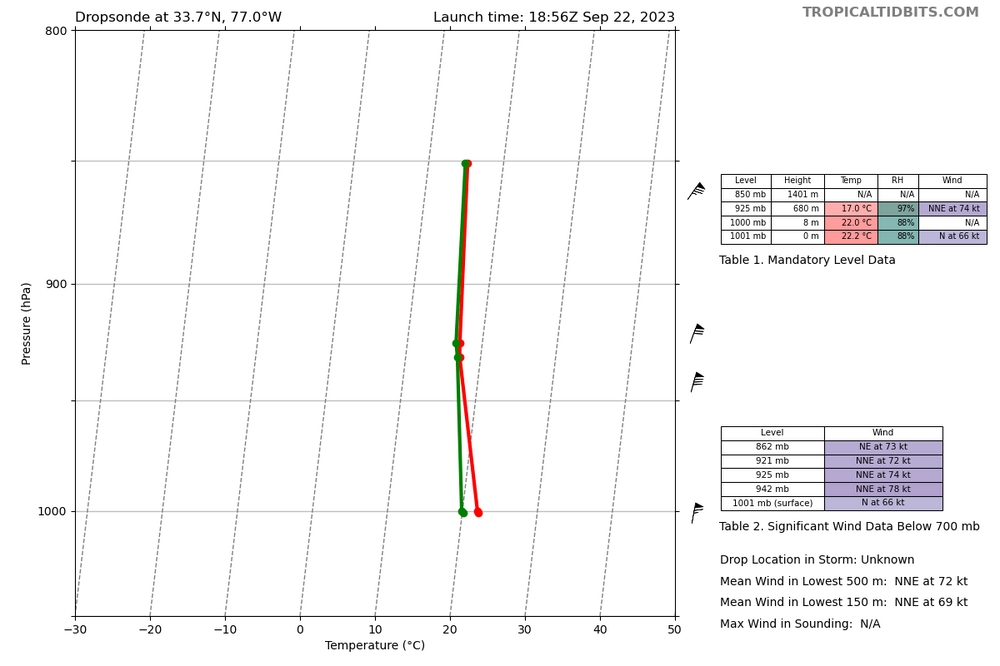
-
Dropsonde found 66kt at surface NW of center. Category 1 threshold is 64kt.

-
You might lose power. Better stock on ice chests instead.
-
I was looking at the shear map’s just yesterday morning expecting that. With the vorticity of a tropical cyclone when storms in its bands come ashore it’s common to get weak tornadoes.