Random Chaos
-
Posts
902 -
Joined
-
Last visited
Content Type
Profiles
Blogs
Forums
American Weather
Media Demo
Store
Gallery
Everything posted by Random Chaos
-
New PDS for the same tornado: Tornado Warning National Weather Service Baltimore MD/Washington DC 729 PM EDT Wed Jun 5 2024 The National Weather Service in Sterling Virginia has issued a * Tornado Warning for... Central Montgomery County in central Maryland... * Until 815 PM EDT. * At 728 PM EDT, a confirmed tornado was located over Germantown, moving east at 25 mph. This is a PARTICULARLY DANGEROUS SITUATION. TAKE COVER NOW! HAZARD...Damaging tornado. SOURCE...Radar confirmed tornado. IMPACT...You are in a life-threatening situation. Flying debris may be deadly to those caught without shelter. Mobile homes will be destroyed. Considerable damage to homes, businesses, and vehicles is likely and complete destruction is possible. * The tornado will be near... Germantown, Rockville, Gaithersburg, Olney, Aspen Hill, Montgomery Village, and Redland around 735 PM EDT. Other locations impacted by this tornadic thunderstorm include Spencerville, Laytonsville, Brookeville, Washington Grove, Sandy Spring, Ednor, Ashton, Brinklow, Derwood, and Burtonsville. PRECAUTIONARY/PREPAREDNESS ACTIONS... To repeat, a large, extremely dangerous and potentially deadly tornado is on the ground. To protect your life, TAKE COVER NOW! Move to a basement or an interior room on the lowest floor of a sturdy building. Avoid windows. If you are outdoors, in a mobile home, or in a vehicle, move to the closest substantial shelter and protect yourself from flying debris. && TIME...MOT...LOC 2328Z 247DEG 21KT 3914 7728 TORNADO...OBSERVED TORNADO DAMAGE THREAT...CONSIDERABLE MAX HAIL SIZE...<.75 IN $$ DHOF
-
Here’s the report from Montgomery County: 631 NWUS51 KLWX 052322 LSRLWX Preliminary Local Storm Report National Weather Service Baltimore MD/Washington DC 722 PM EDT Wed Jun 05 2024 ..TIME... ...EVENT... ...CITY LOCATION... ...LAT.LON... ..DATE... ....MAG.... ..COUNTY LOCATION..ST.. ...SOURCE.... ..REMARKS.. 0711 PM Tornado 1 S Poolesville 39.13N 77.41W 06/05/2024 Montgomery MD Trained Spotter Local spotter confirmed tornado lofting debris into the air. && Event Number LWX2403236 $$
-
PDS: Severe Weather Statement National Weather Service Baltimore MD/Washington DC 722 PM EDT Wed Jun 5 2024 ...A TORNADO WARNING REMAINS IN EFFECT UNTIL 745 PM EDT FOR CENTRAL MONTGOMERY COUNTY... At 722 PM EDT, a confirmed tornado was located near Boyds, or near Poolesville, moving east at 20 mph. This is a PARTICULARLY DANGEROUS SITUATION. TAKE COVER NOW! HAZARD...Damaging tornado. SOURCE...Weather spotters confirmed tornado. IMPACT...You are in a life-threatening situation. Flying debris may be deadly to those caught without shelter. Mobile homes will be destroyed. Considerable damage to homes, businesses, and vehicles is likely and complete destruction is possible. The tornado will be near... Germantown, Gaithersburg, Montgomery Village, North Potomac, and Boyds around 725 PM EDT. Other locations impacted by this tornadic thunderstorm include Dawsonville and Darnestown. PRECAUTIONARY/PREPAREDNESS ACTIONS... To repeat, a large, extremely dangerous and potentially deadly tornado is on the ground. To protect your life, TAKE COVER NOW! Move to a basement or an interior room on the lowest floor of a sturdy building. Avoid windows. If you are outdoors, in a mobile home, or in a vehicle, move to the closest substantial shelter and protect yourself from flying debris. Heavy rainfall may hide this tornado. Do not wait to see or hear the tornado. TAKE COVER NOW! && TIME...MOT...LOC 2322Z 258DEG 18KT 3915 7735 TORNADO...OBSERVED TORNADO DAMAGE THREAT...CONSIDERABLE MAX HAIL SIZE...<.75 IN $$ DHOF
- 1,696 replies
-
- 2
-

-
- severe
- thunderstorms
- (and 5 more)
-
Great signature: Edit: New image - looks like maybe a debris ball on CC:
-
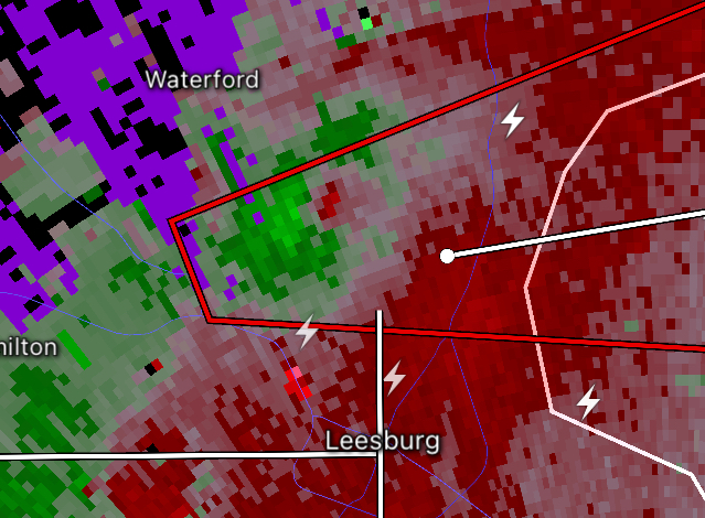
System just east of Poolsville looks like it has a couplet and hook.
-
And another north of Baltimore: Tornado Warning National Weather Service Baltimore MD/Washington DC 659 PM EDT Wed Jun 5 2024 The National Weather Service in Sterling Virginia has issued a * Tornado Warning for... West central Harford County in northern Maryland... Northeastern Baltimore County in northern Maryland... * Until 745 PM EDT. * At 659 PM EDT, a severe thunderstorm capable of producing a tornado was located over Hampton, or near Cockeysville, moving northeast at 15 mph. HAZARD...Tornado. SOURCE...Radar indicated rotation. IMPACT...For those in the direct path of a tornado touchdown, flying debris will be dangerous to those caught without shelter. Damage to roofs, siding, and windows may occur. Mobile homes may be damaged or destroyed. Tree damage is likely. * This dangerous storm will be near... Cockeysville, Carney, Perry Hall, Rossville, Timonium, White Marsh, Fallston, Hampton, Kingsville, and Pleasant Hills around 705 PM EDT. Other locations impacted by this tornadic thunderstorm include Nottingham, Glen Arm, Fork, Benson, Fullerton, Baldwin, Lutherville, Long Green, Eudowood, and Hydes. PRECAUTIONARY/PREPAREDNESS ACTIONS... TAKE COVER NOW! Move to a basement or an interior room on the lowest floor of a sturdy building. Avoid windows. If you are outdoors, in a mobile home, or in a vehicle, move to the closest substantial shelter and protect yourself from flying debris. && TIME...MOT...LOC 2259Z 210DEG 11KT 3940 7657 TORNADO...RADAR INDICATED MAX HAIL SIZE...<.75 IN $$ DHOF
-
Another TOR further north: Tornado Warning National Weather Service Baltimore MD/Washington DC 700 PM EDT Wed Jun 5 2024 The National Weather Service in Sterling Virginia has issued a * Tornado Warning for... East central Frederick County in north central Maryland... * Until 730 PM EDT. * At 700 PM EDT, a severe thunderstorm capable of producing a tornado was located near Walkersville, or near Frederick, moving northeast at 20 mph. HAZARD...Tornado. SOURCE...Radar indicated rotation. IMPACT...For those in the direct path of a tornado touchdown, flying debris will be dangerous to those caught without shelter. Damage to roofs, siding, and windows may occur. Mobile homes may be damaged or destroyed. Tree damage is likely. * This tornadic thunderstorm will remain over mainly rural areas of east central Frederick County in north central Maryland, including the following locations... Libertytown and Unionville. PRECAUTIONARY/PREPAREDNESS ACTIONS... TAKE COVER NOW! Move to a basement or an interior room on the lowest floor of a sturdy building. Avoid windows. If you are outdoors, in a mobile home, or in a vehicle, move to the closest substantial shelter and protect yourself from flying debris. && TIME...MOT...LOC 2300Z 246DEG 18KT 3947 7730 TORNADO...RADAR INDICATED MAX HAIL SIZE...<.75 IN $$ DHOF
-
Huge new TOR - multiple rotating centers: Tornado Warning National Weather Service Baltimore MD/Washington DC 653 PM EDT Wed Jun 5 2024 The National Weather Service in Sterling Virginia has issued a * Tornado Warning for... Northwestern Montgomery County in central Maryland... Southeastern Frederick County in north central Maryland... Northeastern Loudoun County in northern Virginia... * Until 730 PM EDT. * At 652 PM EDT, severe thunderstorms capable of producing brief tornadoes were located along a line extending from 6 miles east of Point Of Rocks to near Poolesville to Leesburg, moving east at 20 mph. HAZARD...Tornado. SOURCE...Radar indicated rotation. IMPACT...For those in the direct path of a tornado touchdown, flying debris will be dangerous to those caught without shelter. Damage to roofs, siding, and windows may occur. Mobile homes may be damaged or destroyed. Tree damage is likely. * These dangerous storms will be near... Leesburg, Lansdowne, and Poolesville around 700 PM EDT. Boyds around 705 PM EDT. Germantown and Damascus around 710 PM EDT. Other locations impacted by these tornadic storms include Clarksburg, Dickerson, Beallsville, Dawsonville, Tuscarora, Barnesville, and Darnestown. PRECAUTIONARY/PREPAREDNESS ACTIONS... TAKE COVER NOW! Move to a basement or an interior room on the lowest floor of a sturdy building. Avoid windows. If you are outdoors, in a mobile home, or in a vehicle, move to the closest substantial shelter and protect yourself from flying debris. This line of thunderstorms is capable of producing tornadoes. Do not wait to see or hear the tornado. For your protection move to an interior room on the lowest floor of a building. && TIME...MOT...LOC 2252Z 259DEG 16KT 3926 7743 3919 7749 3913 7754 TORNADO...RADAR INDICATED MAX HAIL SIZE...<.75 IN $$ DHOF
-
Look at differential phase for the Leesburg tor. I’d post but am on a tablet at the moment and can’t get the size small enough. edit, has weakened since i looked.
-
Pretty decent couplet on that storm north of Leesburg:
- 1,696 replies
-
- 2
-
-
- severe
- thunderstorms
- (and 5 more)
-
I picked up 0.71" of rain.
-
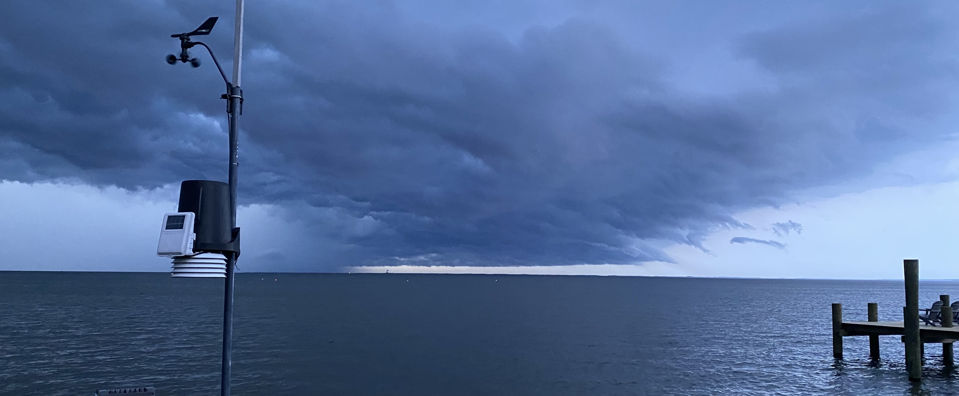
Great clouds passing over the bay:

- 1,696 replies
-
- 10
-
-
- severe
- thunderstorms
- (and 5 more)
-
Radar scope pro picked something up there:
-
MoCo storm now warned - 60mph winds, up to 3/4" hail. Also new meso out calls for possible tornados over northern Chesapeake Bay.
-
Also looks interesting on KDOX.
-
77.8F temp / 74.0F dp / sunny.
-

April 8th Eclipse- Last Easy One To See In My Lifetime
Random Chaos replied to Interstate's topic in Mid Atlantic
If you had a hydrogen alpha scope, there was a spectacular arch shaped promenance erupting from the bottom of the sun that whe the eclipse started was sticking well past the moon while the sun it came from was hidden! -
The Weekend Rule? Saturday 2/17 - The Icon Storm
Random Chaos replied to DDweatherman's topic in Mid Atlantic
Dusting here. Mist of the ground is bare but some locations have snow. -
The Weekend Rule? Saturday 2/17 - The Icon Storm
Random Chaos replied to DDweatherman's topic in Mid Atlantic
If you’re not familiar with Maryland’s lidar map, it includes DC and is awesome: https://geodata.md.gov/topoviewer/ -
The Weekend Rule? Saturday 2/17 - The Icon Storm
Random Chaos replied to DDweatherman's topic in Mid Atlantic
I’m confused on the LWX snow graphics. They list worst case as most snow. Isn’t that best case? Worst case is no snow -
The Weekend Rule? Saturday 2/17 - The Icon Storm
Random Chaos replied to DDweatherman's topic in Mid Atlantic
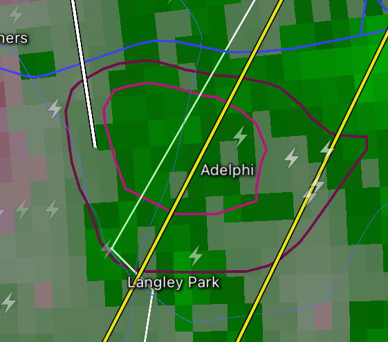
Don’t think anyone posted this yet…
-
Jan/Early Feb Medium/Long Range Discussion Part 3
Random Chaos replied to WinterWxLuvr's topic in Mid Atlantic
*jots down note* Snow on April 8th, 2024 during solar eclipse. Gotcha! Don't have to worry about sun angle during an eclipse. -
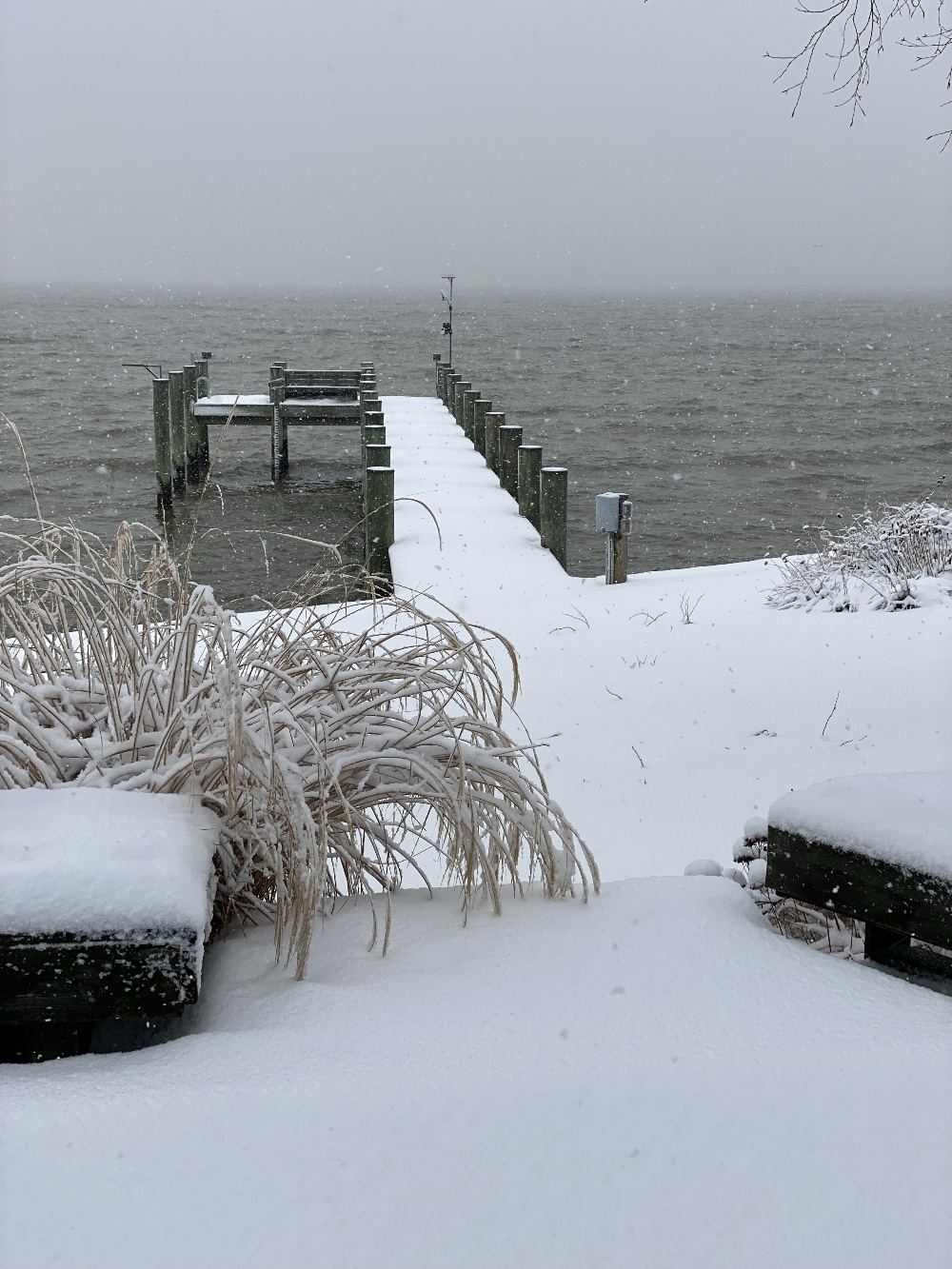
Just measured: 1.5" near the house (~50-75 feet from Chesapeake Bay) 3.5" further inland (~125 feet from Chesapeake Bay) Might be more up at the road (~400 feet from bay), but didn’t walk that far. Typical for snow storms for me. One reason I never do skywarn reporting on snow accumulation - between wind and temperature differences due to the bay, I often have drifting and/or a depth gradient with more snow further from the water.
-
Haven’t had a lot of accumulation here, but it sure is pretty! I was above freezing until after dawn, sitting at 30.7F now. Photo of my weather station in SN:

-
Clearly it's about who creates the thread as to whether we get an event.