Random Chaos
-
Posts
871 -
Joined
-
Last visited
Content Type
Profiles
Blogs
Forums
American Weather
Media Demo
Store
Gallery
Everything posted by Random Chaos
-

Late January and February Medium/Long Range Discussion
Random Chaos replied to WinterWxLuvr's topic in Mid Atlantic
0z looks very similar to the previous 6z at 144+/-. -
Late January and February Medium/Long Range Discussion
Random Chaos replied to WinterWxLuvr's topic in Mid Atlantic
I like the run-to-run consistency! Our best storms almost always show that at this range. Snowicane here we come!- 4,130 replies
-
- 1
-

-
- prime climo
- cold canada
- (and 1 more)
-
Late January and February Medium/Long Range Discussion
Random Chaos replied to WinterWxLuvr's topic in Mid Atlantic
What I like: This storm has been periodically showing up on long ranges for several days now. Those that miss are missing east or not developing at all - and it seems like we get a east bias at range so that's in our favor for those that do put out a fish spinner. What I don't like: It's still way too far out! Give it 3-4 days and I'll be onboard, especially if it's a little east of us.- 4,130 replies
-
- 1
-
-
- prime climo
- cold canada
- (and 1 more)
-
5 feet of snow right on top of Ji and everyone else is in a snow hole.
-
Thursday 1/20/22 Stat Padder Discussion and Observations
Random Chaos replied to stormtracker's topic in Mid Atlantic
51.0 / 36.7 -
Thursday 1/20/22 Stat Padder Discussion and Observations
Random Chaos replied to stormtracker's topic in Mid Atlantic
Nothing beats the CRAS -
January 16-17, 2022 MLK storm obs/now cast
Random Chaos replied to George BM's topic in Mid Atlantic
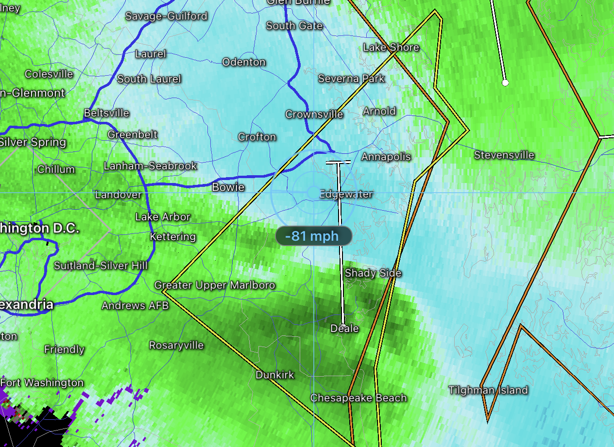
985.8mb, temperature up to 49.4F -
January 16-17, 2022 MLK storm obs/now cast
Random Chaos replied to George BM's topic in Mid Atlantic
Winds howling now. 32mph. Gusts to 38. That was a wierd lull I had earlier.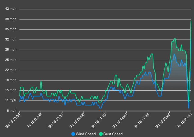
-
January 16-17, 2022 MLK storm obs/now cast
Random Chaos replied to George BM's topic in Mid Atlantic
My wind just died: 23mph 10 minutes ago, 1mph now. Temperature spiked too - up 5F in the last 20 minutes to 44.5F. the intense band is almost to me. Pressure also started going back up. -
January 16-17, 2022 MLK storm obs/now cast
Random Chaos replied to George BM's topic in Mid Atlantic
Now I want snownado! -
January 16-17, 2022 MLK storm obs/now cast
Random Chaos replied to George BM's topic in Mid Atlantic
Some pretty intense winds aloft.
-
January 16-17, 2022 MLK storm obs/now cast
Random Chaos replied to George BM's topic in Mid Atlantic
It is a severe thunderstorm warning. And a special marine warning for waterspouts and wind! -
January 16-17, 2022 MLK storm obs/now cast
Random Chaos replied to George BM's topic in Mid Atlantic
Waterspouts possible… -
January 16-17, 2022 MLK storm obs/now cast
Random Chaos replied to George BM's topic in Mid Atlantic
Here we go! -
Volcanic Winter 2022?
Random Chaos replied to Tallis Rockwell's topic in Weather Forecasting and Discussion
Volcano Cafe is great! Always read it after an event, mostly lurker there but occasionally post. Got me to check my weather station for the shockwave: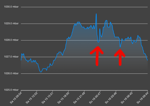
-
Some incredible statistics about the Tonga eruption here - including record cold temperature detected by a satellite and over 400k lightening strikes in just a few hours: https://cimss.ssec.wisc.edu/satellite-blog/ (unfortunately no direct article link available, it’s the post on Jan 15th) And here are some other great satellite views of the eruption:
-
January 16-17, 2022 MLK storm obs/now cast
Random Chaos replied to George BM's topic in Mid Atlantic
25.6/8.2 10-15mph wind N to NNE Near Annapolis. -
I’m not sure that’s quite what is depicted. The wind doesn’t really pick up on the NAM until after the rain transition on the model. That ZR is almost entirely before the big rain mass reaches us. If you look at the 850 winds at 0z Monday on the 12z NAM, the mass of wind has just reached DC and already the ZR has pulled north of DC.
-
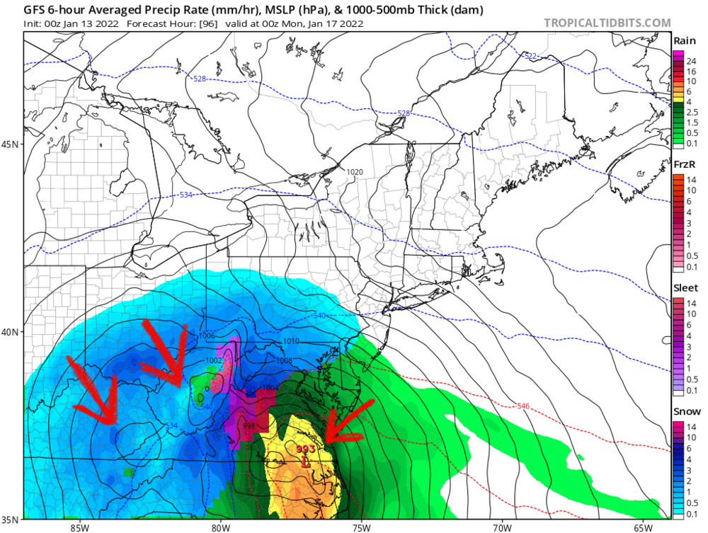
Looks to me the biggest problem with the models is consolidating the low pressure in a single location. The GFS is jumping back and forth between 2 of these lows, and that seems to be what is making the sudden west jog jyst before it hits us:
-
I’m thinking of the storm a week ago. The GFS had it a week ahead, then lost it, only to get it back 2 days ahead, then stuck verbatim and we got a good storm. Next few days could be rough but lets not write this thing off from run to run oscillation. There’s definitely something going on with the op vs ensembles but no clue what. Remember thst data for this storm is originating out over the pacific now - mostly satellite derived data which is less accurate than ground stations.
-
That’s my usual process
-
That’s exactly what I was thinking, just wondering if there was a study on it. Not talking verification scores so much as how these permutations are amplified. The raw data ingested is not exact, especially data that originated west of California, and errors or inaccuracies in the data could be amplified in the 5+ day period for us on the east coast in higher resolution models.
-
I wonder, have there been any studies on the accuracy of a model at medium to long range when run at different resolutions? It seems to me that both the Euro and GFS were better at the 5+ day range (more consistent run-to-run) back before the resolution upgrades that started a number of years back. I’m bringing this up because the EPS and GEFS are run at lower resolution and both have eastern tracks vs the op. Wondering if errors are getting amplified at range with these higher resolution models.
-
I’ll take P15.
-
Clearly you need to drive more around the DC area after a storm