dseagull
-
Posts
504 -
Joined
Content Type
Profiles
Blogs
Forums
American Weather
Media Demo
Store
Gallery
Everything posted by dseagull
-
January 28/29 Blizzard Observations/Discussion/Nowcasting
dseagull replied to Northof78's topic in New York City Metro
-
January 28/29 Blizzard Observations/Discussion/Nowcasting
dseagull replied to Northof78's topic in New York City Metro
You may be right. Not sure we will get accurate measurements. That 12.5 in Forked river was almost 2 hours ago and we are still getting 2-3 inch an hour. Who knows. Good storm. -
January 28/29 Blizzard Observations/Discussion/Nowcasting
dseagull replied to Northof78's topic in New York City Metro
Someone in Ocean County will get a lollipop of 2 foot of powder.. rates are INSANE right now. 3 more hours of this will give someone 8 additional inches. -
January 28/29 Blizzard Observations/Discussion/Nowcasting
dseagull replied to Northof78's topic in New York City Metro
Getting absolutely pummeled by this band. It looks to have dropped nearly 6 more inches in two hours. -
January 28/29 Blizzard Observations/Discussion/Nowcasting
dseagull replied to Northof78's topic in New York City Metro
I'm 3 miles south of there. Incredibly difficult to measure, but it's still ripping. -
January 28th/29th Event Obs - From KU to FU?
dseagull replied to JTA66's topic in Philadelphia Region
I believe it, I'm 3 miles south of Forked River. Last hour was near whiteout for a short period of time. -
January 28th/29th Event Obs - From KU to FU?
dseagull replied to JTA66's topic in Philadelphia Region
Current band has to have 2+ inch/ht rates. Absolutely puking snow with sustained wind pushing 35-40. -
January 28th/29th Event Obs - From KU to FU?
dseagull replied to JTA66's topic in Philadelphia Region
To my untrained eye, the storm just went on a rapid tilt, and looks to be really pumping some moisture over us now... intensity comes and goes, but I think I'll see over at foot on barnegat bay. Impossible to measure. -
January 28th/29th Event Obs - From KU to FU?
dseagull replied to JTA66's topic in Philadelphia Region
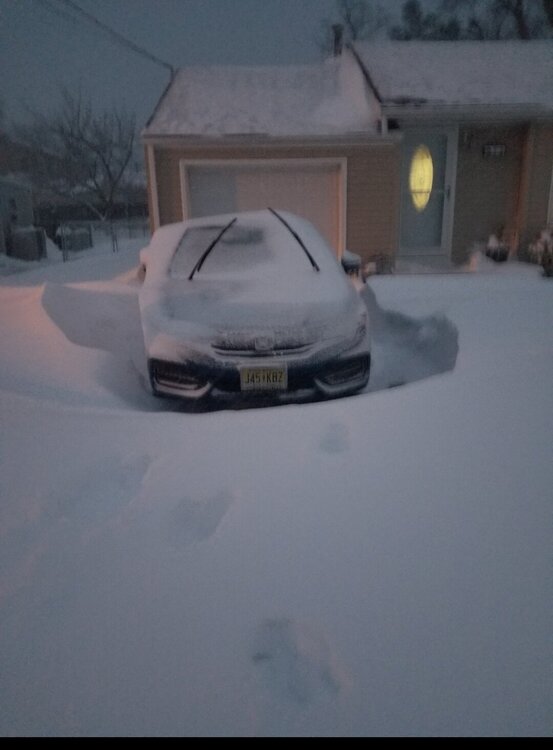
Ripping fatties on Barnegat Bay... Much to my dismay, my GSP will hunt in any condition, but wanted no part in the 40+mph wind and sideways snow. Going to be nearly impossible to measure snow. Have bare ground less than 5 feet from 3+ foot drifts. Wind keeps increasing. -
January 28/29 Blizzard Observations/Discussion/Nowcasting
dseagull replied to Northof78's topic in New York City Metro
That band is dumping good, and someone flipped the switch on the fan. Looks like that band is going to setup west of me. -
January 28/29 Blizzard Observations/Discussion/Nowcasting
dseagull replied to Northof78's topic in New York City Metro
Finally moderate snow and the roads have caved with the temps and intensity. Flake size increased and wind continues to ramp up. Should absolutely DUMP from 2AM-8AM -
January 28th/29th Event Obs - From KU to FU?
dseagull replied to JTA66's topic in Philadelphia Region
For totals, I still wouldn't trust it as far as I could throw it, but for precip location and banding during an approaching storm, absolutely. Just my opinion from over the years. -
January 28/29 Blizzard Observations/Discussion/Nowcasting
dseagull replied to Northof78's topic in New York City Metro
Radar filling in offshore, and temp just crashed to 30.9 from 33.7 in the past half hour. Dusting remains and light snow just began again after a brief lull. Game time. -
Radar and short term models are going to play so many tricks on those who have stayed up for the past week for all of the runs. (Myself included) Its Friday Night Game Time... Rally the Troops.
-
Time will tell. I fish the NE and have for 30+ years. I also take monthly samples that are irrelevant compared to SST satellite temps. Too many variables to draw conclusions to any single event, let alone season. Still enjoy. And still see potential. just ramping up. Edit: commercially fish and observe the NE canyons for a living. (Walking dog and typing...give me a break)
-
They weren't, and I'll eat crow when the fat lady sings her tune. Going to have some further praise towards the GFS if the signal was indeed first recognized by the least trusted models prior to 48 hours. Going to be an interesting year end report by many forecasters. Storm is bombing out. Let's enjoy.
-
Beautiful
-
Pixie dust begins on Barnegat Bay. Returns should fill in over the next 45-60 minutes. A band is going to set up north of here within 2 hours. 2018 redux version? Edit : light snow came in like a wall within 2 minutes, and large flakes. Instantly beginning to cover lawn, boat, and car.
-
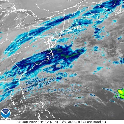
Going to be plenty of surprises... thing is cranking now. Bombs away. Look at the satelite satellite presentation. Further NE, but this thing is going to set up some incredible rates in these bands with the expansion. NYC still getting a foot. Coastal Monmouth and Ocean in Jersey will see pockets of 18 plus. Good storm. Beautiful transition from something we discounted less than 36-48 hours ago... and on a weekend none the less.
-
Been agreeing with you since early on. Not wavering. NYC PROPER, will see a foot of snow... I don't have the time to post the live product graphics. This STILL has a classic bomb signature. Not sure I understand the mood swings. Everything is coming together. Enjoy folks.
-
Lighting beginning to fire ENE off hatteras... building... (no way to load such high res. Imagery loops) Still, looks perfect.
-
Prior to now. Everything looks great with presentation. WV loop looks even better if you want to see the beginning of tilt and (maybe) future capture. This is going to explode.
-
What graphics are you using and what are they derived from? Just curious.
-
Gotcha... understand... I'd be happy to have that convo in banter.
-
Engine is about to turn over. Still looks perfect.