tnweathernut
-
Posts
4,746 -
Joined
-
Last visited
Content Type
Profiles
Blogs
Forums
American Weather
Media Demo
Store
Gallery
Everything posted by tnweathernut
-

January Medium-Long Range Discussion
tnweathernut replied to Holston_River_Rambler's topic in Tennessee Valley
It's no wonder we have so few statewide events. Here in the Tri-Cities, I can get to Canada quicker than I can Memphis. Just so hard to align a storm west to east over that type of distance. Someone usually gets hosed. -
January Medium-Long Range Discussion
tnweathernut replied to Holston_River_Rambler's topic in Tennessee Valley
Biggest things I noticed were: 1. The OP has the ridge off the west coast tipping to the northeast. This invites the northern stream to roll downhill further southwest, interacting with the southern branch feature and pumping the heights in the east just enough to screw up something possibly great. 2. The ensemble is smoothed (I get that), but if it has any energy in the southern branch it is suppressed. Since the ridge off the west coast doesn't tip northeast, the cold shot progresses to the SE. -
January Medium-Long Range Discussion
tnweathernut replied to Holston_River_Rambler's topic in Tennessee Valley
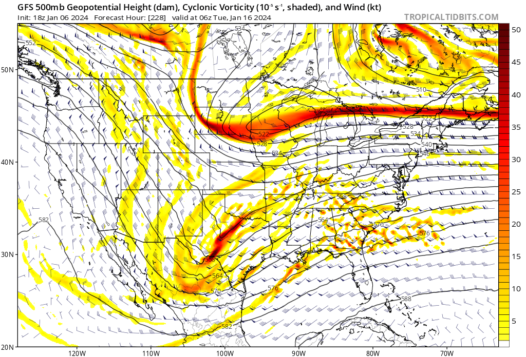
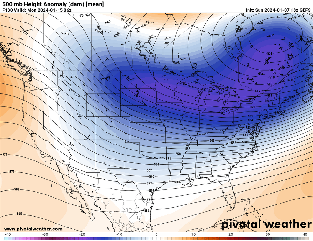
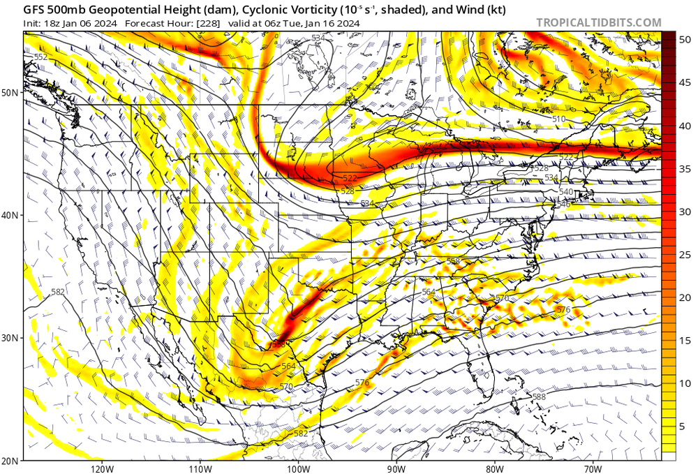
Just looking at the operational 18z vs the ensemble at 500 at hour 180 (truncation). See if you can spot the differences.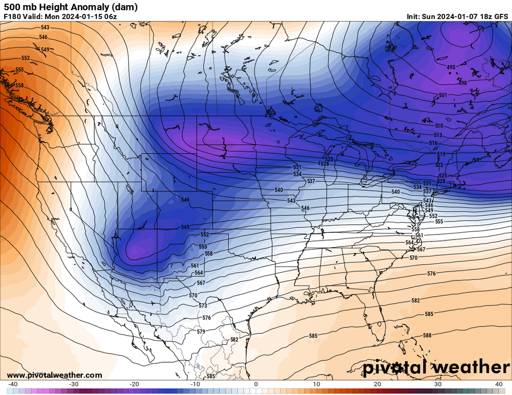
-
January Medium-Long Range Discussion
tnweathernut replied to Holston_River_Rambler's topic in Tennessee Valley
Euro will cut. Northern and southern stream started interacting with each other way out west…. Maybe it’s a step in the right direction, time will tell. There are differences even at hour 120 evident, so will likely work out the correct (west vs east) sooner than later. -
January Medium-Long Range Discussion
tnweathernut replied to Holston_River_Rambler's topic in Tennessee Valley
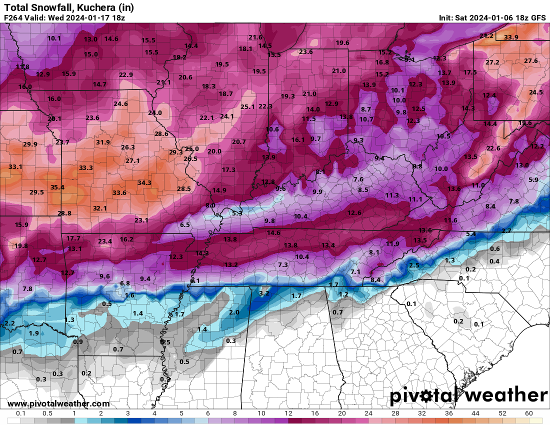
I mean, I think we would all be willing to be patient if this type of event unfolded. I knew it was going to be a banger run when I was following 500 and saw this map......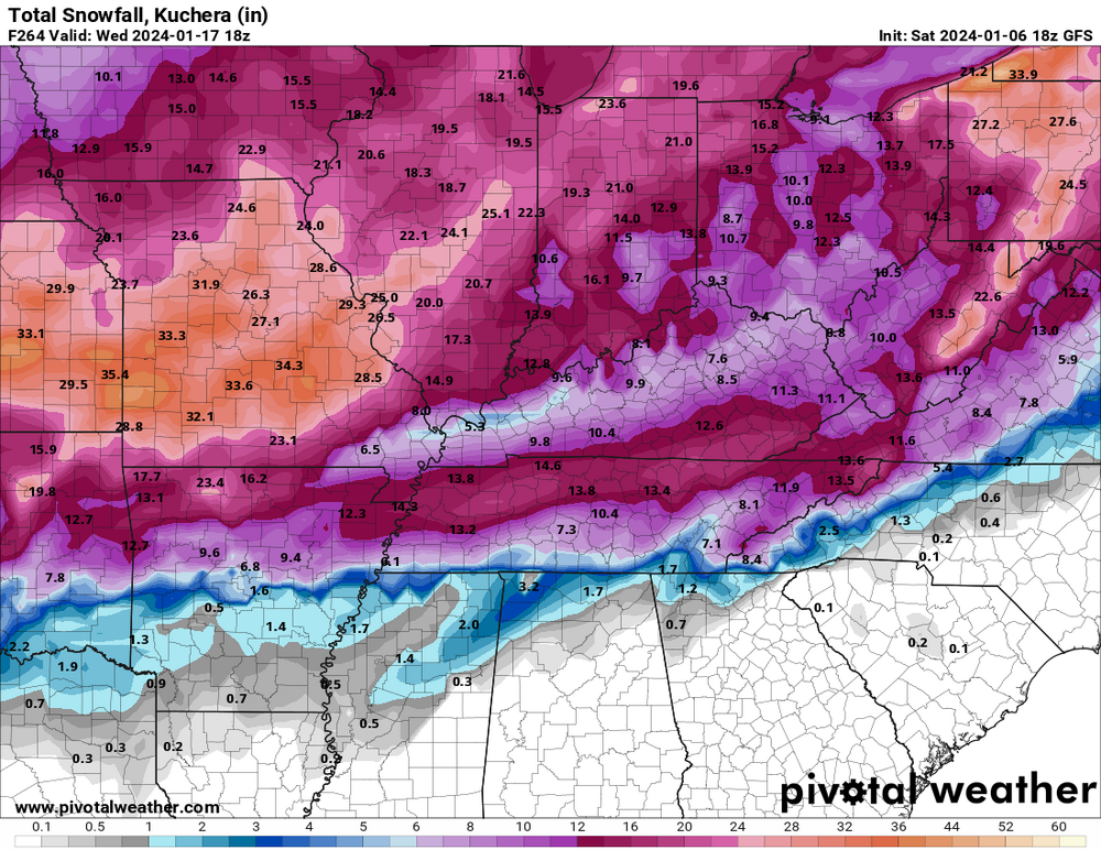
-
January Medium-Long Range Discussion
tnweathernut replied to Holston_River_Rambler's topic in Tennessee Valley
Looks like a phaser or phaser potential............ Nice to see it as a possibility, even if still in the land of make believe. -
January Medium-Long Range Discussion
tnweathernut replied to Holston_River_Rambler's topic in Tennessee Valley
Major winter storm incoming on HH GFS. Under day 10. This is progress. lol -
January Medium-Long Range Discussion
tnweathernut replied to Holston_River_Rambler's topic in Tennessee Valley
96 was the last time i remember snow on snow and significant snow on the ground for 2 straight weeks, with snow mounds all over the parking lots around the city. If I remember correct, we got it going by having a heavy rain change to heavy snow. I remember everyone in college talking about how the weather guys missed another one when the heavy rain was falling.. lol -
January Medium-Long Range Discussion
tnweathernut replied to Holston_River_Rambler's topic in Tennessee Valley
Banter, but.................another pipe busting cold snap with no snow would kill my soul. Just want to put that out there. I'm sure I'm not alone. lol -
January Medium-Long Range Discussion
tnweathernut replied to Holston_River_Rambler's topic in Tennessee Valley
The progression of the 12z Euro makes more sense than other modeling, IMO. First system is passing this weekend, second system (much stronger) early next week winds up and cuts into the lakes. This should move the boundary further east while the next system dives into the southern plains and takes a track a bit further to the south and east. Because of this, I think the system later next week (day 6) has a snow/ice axis somewhere that will put the western to middle Tennessee area and/or Arkansas/northern MS in play. I think East TN has to wait to see if there is a system following the much bigger push of very cold air that will try and make its move east following the late week system. Hope modeling can start to converge around the 12z Euro (outlier) and our bothers/sisters west of us will have a system to track. -
January Medium-Long Range Discussion
tnweathernut replied to Holston_River_Rambler's topic in Tennessee Valley
You didn't have to go back in the archives very far for this, but I'm always amazed at the historical value you bring to our forum. It's always fascinating. Thank you. -
January Medium-Long Range Discussion
tnweathernut replied to Holston_River_Rambler's topic in Tennessee Valley
It's the south, so we do the no snow drill well, but the worst is when we have robust system after system with rain in front and winters cold behind.......... only to finally get the consistent cold needed and then go bone dry for 10 days. lol -
January Medium-Long Range Discussion
tnweathernut replied to Holston_River_Rambler's topic in Tennessee Valley
Honestly, that's the last thing I want to hear. My insurance book of business still hasn't recovered from the pipes that were bursting all over northeast TN last Christmas. -
January Medium-Long Range Discussion
tnweathernut replied to Holston_River_Rambler's topic in Tennessee Valley
Tell your wife to hang in there! Prayers for a speedy recovery for her. -
January Medium-Long Range Discussion
tnweathernut replied to Holston_River_Rambler's topic in Tennessee Valley
I take comfort in seeing every storm too north with rain and too south suppressed. I take comfort because I know it's all wrong beyond day 7. Plenty of time to morph into something favorable. -
January Medium-Long Range Discussion
tnweathernut replied to Holston_River_Rambler's topic in Tennessee Valley
I definitely agree with this. I don't like a PV that splits. Such a low chance it even helps eastern North America! -
January Medium-Long Range Discussion
tnweathernut replied to Holston_River_Rambler's topic in Tennessee Valley
That system around the 12-14th will have to be watched, IMO. The system that runs in front of it may set the table for that one. Just need our new fangled SE trend to help us out for once. There also seems to be a decent high over the top for that period........... -
January Medium-Long Range Discussion
tnweathernut replied to Holston_River_Rambler's topic in Tennessee Valley
Now you can't even get the euro to agree with the euro. lol -
Winter 23-24' Wx Observations Thread
tnweathernut replied to Carvers Gap's topic in Tennessee Valley
We had a heavy dusting in north Johnson City this morning. -
January Medium-Long Range Discussion
tnweathernut replied to Holston_River_Rambler's topic in Tennessee Valley
The torch didn't materialize, but neither has a legit snow opportunity. I think it's a pretty good bet the MJO makes it to "unfavorable". This will have us hoping for a perfectly placed block to help save the day for some in the TN Valley Region. Talk about threading the needle. I'm usually optimistic, but I have reached an age where front side ice to rain and backside rain to snow shower chances no longer move the needle. Lots of moving parts, and it's still pretty early in the winter so gives reasons to remain grounded. I think my biggest gripe is (and maybe it's just a false perception) modeling being no better than a roll of the dice today vs 10 years ago. We used to know the tendencies of each model and could apply that knowledge in productive way. Now it seems modeling either against old known tendencies or worse, all over the place. I know we all stare at every model run, but I have zero faith in modeling - even as close as 3-5 days out. Maybe it's just me and I'm getting old and cranky........ lol -
January Medium-Long Range Discussion
tnweathernut replied to Holston_River_Rambler's topic in Tennessee Valley
Interestingly, it seems the last several systems (the one for tomorrow included) have ended up weaker and to the SE. -
January Medium-Long Range Discussion
tnweathernut replied to Holston_River_Rambler's topic in Tennessee Valley
Maybe the first widespread snow for our area will follow the thunder we will have next Tuesday (8 days from today)? lol -
January Medium-Long Range Discussion
tnweathernut replied to Holston_River_Rambler's topic in Tennessee Valley
I was thinking the same thing. -
January Medium-Long Range Discussion
tnweathernut replied to Holston_River_Rambler's topic in Tennessee Valley
Has been a thorn in the side of snow lovers here in east TN numerous times over the years. Any semblance of energy west of the apps would really hurt chances of a winter event for those east of the plateau (except maybe SW VA), outside of a mixed precip to rain type deal with really good timing (i.e. overnight/early am arrival). Would really like to see a consolidated low pass well to the southeast of our area. Without an unusually cold high structure over the top, a piece of energy west of the apps will make a winter event almost impossible to work for those outside of elevation east of the plateau or the CAD favored regions east of the Apps. We may get this type of setup later in the month if some of the ensembles showing the polar vortex trapping underneath blocking have some truth to them. It’s fun to imagine an active southern branch with very cold air trapped and pressing into a good chunk of the country. This winter already feels much different than last, even if we don’t score a winter storm over the next week. -
January Medium-Long Range Discussion
tnweathernut replied to Holston_River_Rambler's topic in Tennessee Valley
Likely this one. Should probably also put this in banter, but it's not like we are tracking, so I will put it here. If a mod wants to move it, so be it. Deaths blamed on heavy Appalachian snowfall http://www.cnn.com/WEATHER/9801/29/winter.storm/traffic.boone.jpg Commuters brave icy roads in Boone, North Carolina January 29, 1998 Web posted at: 12:38 p.m. EDT (1238 GMT) (CNN) -- At least nine deaths were blamed Thursday on a storm that dumped several feet of snow on the central Appalachians starting Tuesday night, clogging highways with ice, snow, and snowbound vehicles. The storm also took out electrical service for thousands of customers in eastern Tennessee, West Virginia and North Carolina; by early Thursday morning, 258,000 households in those states were still without power. The storm had largely turned to rain on the coast by Wednesday, stirring up a pounding surf that pulled one empty house and part of another into the Atlantic Ocean near Virginia Beach, Virginia. The South looks more like the North http://www.cnn.com/images/9706/qt_icon.gif 786K/21 sec. QuickTime movie But it was the heavy snow that caught the region off-guard. "This was worse than the blizzard of February 1993," said Bobbie Freeman, the fire chief of Jonesborough, Tennessee. "This snow was so wet that trees were coming down everywhere." Buildings collapse under snow's weight http://www.cnn.com/WEATHER/9801/29/winter.storm/tree.wv.jpg allen tree limbs damage power lines in Beckley, West Virginia Power remained out in parts of the state, with 80,000 to 90,000 people in northeastern Tennessee still coping without electrical service by Thursday morning. Tennessee's Carter County was hit especially hard by the storm. Up to 4 feet of snow fell on the county's Roan Mountain; flooding in Carter County just 2 1/2 weeks ago killed seven people. About 75 percent of the county had no power, and it could be five days before service is restored, said Sheriff John Henson. "We need a break -- a flood one week and a blizzard the next," he said. "I don't know what will come next." The Tennessee National Guard and the Red Cross were providing transportation, manpower and shelters, and the Tennessee Emergency Management Agency has sent personnel to help the local emergency management agencies. National Guard comes to aid of stranded In North Carolina, where the National Guard had been rescuing stranded motorists and taking them to emergency shelters, the snow had begun to melt, allowing traffic along the state's Interstate 40 to start moving again by Thursday. However, melting snow was expected to turn to ice by Thursday night, making travel conditions even trickier. Meanwhile, 12 eastern and southern West Virginia counties were still under a state of emergency. Beckley, West Virginia, received 32 inches of snow, and wasn't expected to get its roads cleared until Thursday at the earliest. "There's got to be somebody in West Virginia with a front-end loader and a dump truck," said William Summers, a South Carolina driver bound for Canada. "If this was the highway commissioner's wife and kids, we would have left here yesterday. It's ridiculous." And the storm's slow sweep over Virginia left behind three dead, two from traffic accidents. A third Virginia man died of an asthma attack while stranded in his rural home. The storm system dumped 20 inches of snow in parts of the state's southwest mountains, and more than 3 inches of rain east and north of the Blue Ridge Mountains. Tides were up to 4 feet above normal.