-
Posts
4,746 -
Joined
-
Last visited
Content Type
Profiles
Blogs
Forums
American Weather
Media Demo
Store
Gallery
Everything posted by tnweathernut
-
Or a change of pants.
-
For everyone that doesn’t know (I didn’t), we have a dedicated thread for late week. :-)
-
Wondering if we can bend the flow enough for a nice 2-4 to 3-6 type overrunning event with good temps. The other two options are we don’t bend it enough and whiff or bend it too much and get more precip but have temp issues. I think the latter is the least likely solution. …….
-
Didn’t realize we had a thread for the late week event. Late week likely has a ceiling keeping a positively tilted trough. This isn’t a terrible thing for a more widespread snow, however it also provides the environment where we lose lift and the moisture feed drys up the further east you go. The higher resolution Euro may be correct in picking this up. Better for temps, worse for totals, especially east and northeast through the mid south into the southern apps. Still a ways to go, but good to see modeling start to come together around a general track as we get closer. Let’s see if we can reel in a winter event, regardless of size.
-
Late week likely has a ceiling keeping a positively tilted trough. This isn’t a terrible thing for a more widespread snow, however it also provides the environment where we lose lift and the moisture feed drys up the further east you go. The higher resolution Euro may be correct in picking this up. Better for temps, worse for totals, especially east and northeast through the mid south into the southern apps. Still a ways to go, but good to see modeling start to come together around a general track as we get closer. Let’s see if we can reel in a winter event, regardless of size.
-
Just one of the many ways we can lose in East TN, albeit one of the more painful ways…. To see a robust system paste west TN, lose punch and thermals into East TN, only to phase with the lakes low to bomb parts of the NE and MA is no bueno if it happens that way. Especially knowing this is our best shot with the great pattern we were seeing at 500 breaking down much quicker than originally shown.
-
It looks to keep its positive tilt at 500 as the trough sweeps through the SE. With no real reinforcing cold high, that might be preferable for a light snow opportunity. Anything that approaches neutral tilt around the MS river at 500 likely destroys thermals without a reinforcing high. If we get that WSW flow and an overrunning light snow…… might be enough to get some of the forum on the board for snow. Long way to go, but fingers crossed.
-
What about ice pack? lol
-
I’m definitely more interested in the storm after the storm….. It looks like the writing is on the wall for a strong push of warming with storm one. I had this written before 12z, but when your 21 yr old daughter home from UT comes to you and asks if you want to take her to Cracker Barrel, the answer is always yes. :-)
-
What would be painful would be for the NAO to not provide enough help for storm one and too much help, squashing storm number 2 ......leaving our area mostly cold and dry. It's definitely on the list of possibilities, so something to watch for when it comes to "ways we can whiff" in the mid-south in what looks like a great pattern at 500mb.... That would probably leave us hoping for a system to attack the backside of the departing pattern, hoping there is enough residual cold for a winter system, while we wait to see if we can reload for a better opportunity.
-
It’s a testament to the pattern we are entering. Never a sure thing in the mid south for snow, but a mean that covers the entire state of TN with 2” is a rarity.
-
That's almost a full day ahead of the OP
-
18z is a full 10 degrees colder from southern Indiana to northern Alabama.
-
Yeah, probably going to make us keep our heads on a swivel. Just put the right “big feature” things in the right places and let’s play ball.
-
Solid step toward other modeling. There were favorable trends west and east at 500 vs 12z
-
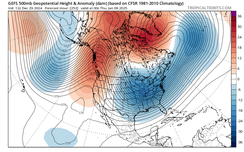
If we can’t score with this pattern at 500mb in the heart of winter, when can we? Still 10 days out, but……….Trends for this general look across ALL modeling has only been strengthening favorably the last 5 days in every area (PNA, AO, NAO, 50/50) & across every model (GFS, GGEM, EPS). You take this look in the mid south/deep south and Carolinas all day every day and twice on Sunday. We may get to roll the dice a few times. Just have to hope we don’t roll snake eyes. JMO
-
A lot of times I won’t even pay much attention to the surface this far out, although I do like to see the monster snow maps. The kid inside never leaves.
-
At the end of the day, we will likely need to see the whites of the eyes of storm one before we know what real chances we may or may not have with the main event. Good pattern coming up, many ways to miss, but a really decent chance to score somewhere along the way. Many years we won’t even have the potential currently showing. For now just sit back and enjoy the occasional DGEX like OP run here and there being spit out.
-
I remembered it as 8-10” with a brief break, followed by another 8-10” in JC. I didn’t measure through my college years, but it was as much snow as i had ever seen and it stuck around for as long as any snow in my 32 years in the TriCities Region.
-
I’m pulling for Miami’s equal chances…….. lol
- 409 replies
-
- 5
-

-

-

-

-
Summer-Fall 2024 Weather Disco Med/Long Range
tnweathernut replied to John1122's topic in Tennessee Valley
.- 689 replies
-
- 1
-

-
- heat
- thunderstorms
- (and 7 more)
-

Summer-Fall 2024 Weather Disco Med/Long Range
tnweathernut replied to John1122's topic in Tennessee Valley
.- 689 replies
-
- 2
-

-
- heat
- thunderstorms
- (and 7 more)
-

February 2024 mid/ long range
tnweathernut replied to Holston_River_Rambler's topic in Tennessee Valley
Systems all year have been trending south and east. Let's see what happens when we need it most. lol- 750 replies
-
- 3
-

-
- snow elk
- wooly worm
-
(and 1 more)
Tagged with:
-

February 2024 mid/ long range
tnweathernut replied to Holston_River_Rambler's topic in Tennessee Valley
For the sake of your (and everyone else’s) property insurance rates, we better hope we get a few tranquil years in a row…. Already seeing 20-35% increases this year, with more likely on the way in the years to come because of the last 3+ years.- 750 replies
-
- 4
-

-
- snow elk
- wooly worm
-
(and 1 more)
Tagged with:
-

February 2024 mid/ long range
tnweathernut replied to Holston_River_Rambler's topic in Tennessee Valley
Not trying to be a wet blanket, but does anyone remember the year where there was almost complete agreement we were headed toward a great pattern. Almost all ensembles were pointing toward it, and I think we were fringe OP range. Then, a SSW occurred and modeling did a 180. I don't remember the year, but I remember having a very different view of SSW's the year that happened.- 750 replies
-
- 1
-

-
- snow elk
- wooly worm
-
(and 1 more)
Tagged with:


