tnweathernut
-
Posts
4,746 -
Joined
-
Last visited
Content Type
Profiles
Blogs
Forums
American Weather
Media Demo
Store
Gallery
Everything posted by tnweathernut
-
The next slide is even better. Just don’t look at it on a full stomach.
-
No, but it is a perfect representation of the battle the mountain counties face a majority of the time when it comes to temps and precip in winter. Shows why we (usually) can’t have nice things. lol
-
@Stovepipe Now that you are here see if your trowel can do something about this downslope/dryslot thing the NAM is throwing at us mountain county folk all the sudden….. lol
-
Stove, my man! Now it’s a party……. Let’s go. Glad to see you.
-
If this is how it plays out with a healthy system west that weakens as it comes east I'd have to give a hat tip to the EURO. It was showing this as a possibility when other modeling wasn't several days out (5-6). Still uncertainty with how the mountains will affect the mountain counties, but as Fountain points out, the mesoscale modeling is picking up on impacts. Usually when we see this it's not wrong. Just have to see how much of an impact comes with it. Minor differences in the next 24-36 hours can mean the difference in a couple of inches of snow for these areas. Hopefully, the NAM is overdoing these issues.
-
Going with the model showing the lowest totals is usually the way to go in Tennessee. Just a casual observation over the last 25 years. lol
-
East TN guys look at your snow map after seeing the mentions of less QPF and then panic before realizing the run hasn't completed yet and it's at least still light snow over our area at 64. lol
-
We haven't discussed this as a possibility, but the convection along the gulf could also be a culprit in reducing QPF for our area. Wouldn't be the first time. Just throwing this out there.
-
New technical term, I like it. "Warm Nosey". Going to use that one from now on.
-
The good news is, this is probably the best position (board wide) we have been in since we have started this forum. We take this setup all day every day and twice on Sunday. It's exactly why we were beating the drum 10 days ago when the ensembles were showing this period as a legit one to watch. It's like we have the All Star team on the field and our .300+ power hitter at the plate with the bases loaded. Good spot to be in for most in here.
-
It was odd because even though it had a trend early for the low to be more northeast, the low track was a weakening low that eventually made its way ESE over FL for a time........ before moving NE. Not going to happen.
-
Stop that, Ryan....... We need to will this one to NOT do this to us.. lol
-
Not sure if it's speed or...........? 12Z NAM has the low about 100-150 miles northeast of its low position from 4 runs ago. It's been trending further northeast each run.
-
I don’t remember how that storm verified, mainly because I don’t remember any snow from last year. lol
-
Good to know. There’s always a model or two that probably make the pros break out in hives leading up to the event.
-
That settles it. Party at D-wags crib.
-
More of a microclimate thing, Jax. Unicoi, Greene & parts of Washington County tend to pull downslopes and dryslots like a magician pulls a rabbit from a hat. It's a talent we have in spades.
-
Don't get me started about this. lol You can ask @Carvers Gapmy thoughts on downsloping/dryslot. Was just mentioning to him this morning about the "double whammy" snow demon not everyone gets the joy of facing. haha I guess when you live where we live you can never really shake it being a concern, but it's less of a concern today than it was 36 hours ago. Trending in the right direction. I like the trajectory of the system and the orientation of the precipitation.
-
The UKIE is in its own world. No other model is taking it across northern FL and out into the Atlantic off the FL coast. For now, I'd toss that run. JMO.
-
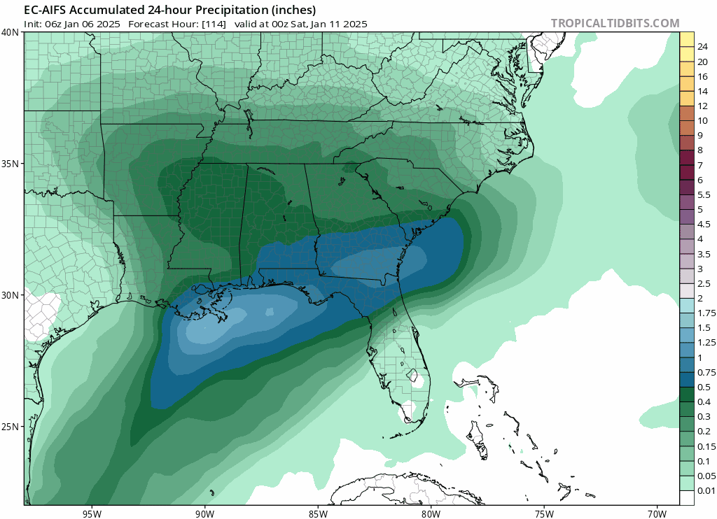
The AI at 6z took the qpf shield south by about 30-40 miles i believe. Wondering if that is the start of a trend? The Euro has never been on board with this. It's been the model that loses the precip shield from the get go. It's either being stubborn or going to lead the way.
-
Not to mention, they just don't belong there. People like DT have zero clue how to make an intelligent snow map for SW VA and the southern Apps. Every time I see one of his snow storm maps I find myself wishing he'd just stop including our area in them. Either broaden your horizon and learn some microclimates outside of your bubble or stop trying. Ok, off my soap box. Oh yeah, and congrats on the snow Blunder!!! I knew you guys were golden for at least a couple of inches with that one.
-
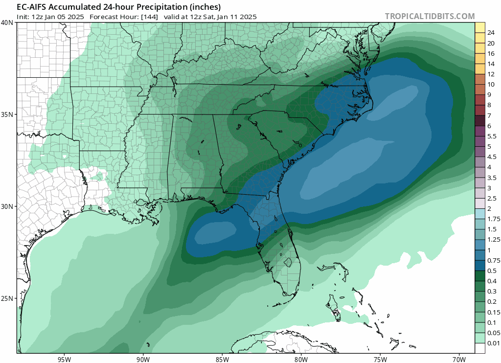
We just have to hope the AI version is smarter than the normal Euro. The regular Euro is insistent upon moisture transport shutting down.
-
The panel before this was similar for the entire state.
-
Be interesting to see if this continues across the 0z suite. Last 3 runs Euro AI definitely beefing up nicely.