tnweathernut
-
Posts
4,746 -
Joined
-
Last visited
Content Type
Profiles
Blogs
Forums
American Weather
Media Demo
Store
Gallery
Everything posted by tnweathernut
-

December/January 2019/20 Winter Speculation Thread
tnweathernut replied to AMZ8990's topic in Tennessee Valley
Maybe, but the moisture stream off the Pacific still looks good. Keep that look consistently and you'd think we have to score eventually. -
December/January 2019/20 Winter Speculation Thread
tnweathernut replied to AMZ8990's topic in Tennessee Valley
back in the day I remember a southwest low not being a terrible thing. Would spit out smaller disturbances and with enough cold provide lighter snow opportunities. Then, when the main system kicked there would be a chance at a major system somewhere in the east. If the cold is tough to dislodge, ice becomes a much bigger concern. Let's see how the pattern evolves. Nothing but good vibes today, which is always fun... -
I was to blame last year. After the Dec snow I went out and bought a UTV and plow.... didn’t snow again. Glad it’s someone else this year.
-
December/January 2019/20 Winter Speculation Thread
tnweathernut replied to AMZ8990's topic in Tennessee Valley
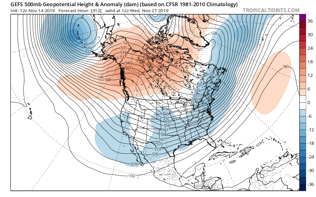
Speaking of LR difficulties in December and if you want to see a great example of the butterfly effect in full effect, take a look at the 500mb level on tropical tidbits beyond day 10. This current run (12z) is night and day different over the top. There is so much blocking showing on this run and it's an almost complete 180 from the last several runs. Just toggle between prior runs and you will see why educated guesses into the future often fail. -
December/January 2019/20 Winter Speculation Thread
tnweathernut replied to AMZ8990's topic in Tennessee Valley
Good stuff the last couple of posts, @Carvers Gap. This may be a bit off topic, but........ It's almost comical when we go back and look through old long range threads we are always talking about the same indexes, what looks good for winter and which things might throw a wrench into things. All I can definitively say is this science (beyond a couple of days) is one of, it not THE toughest things on earth one can venture into to make educated guesses on. I feel like modeling has come a long way in the last couple of decades, but I am not sure the professional community/scientists ever (in our lifetimes) make a ton of headway in long range prediction. The butterfly effect is always working against the smartest individuals the planet has to offer. It's not like we can expect non-linear equations to ever become linear. lol All that said, I can't say how much I appreciate those who do this for a living and how much I am bothered by people with zero understanding cracking meteorologist jokes like it should be easy.. On topic, if a gun was held to my head I'd go with a 65% chance of above normal temps in December with a variable pattern of warm and cold. A lot of this guess is simply based in climatology and the atmosphere acting like a fairly healthy Nino right now. The biggest wildcard is the beating the strat is taking and how that may affects things going forward. -
December/January 2019/20 Winter Speculation Thread
tnweathernut replied to AMZ8990's topic in Tennessee Valley
Winter in the 90's were in a really warm period, yet in northeast Tennessee we managed a great snow year (1996) and two other huge snows (1993 and 1998). I was thinking back to this just a couple of days ago. As warm and "relatively" snowless as that decade was it provided snows and snowy periods not really seen since. I just want to have the internet and modeling we have now and to go have something like that to track.......... Can you all imagine how exhausted we'd be if we were tracking another 1993 from 7-10 days out?? As far as where we go in December, I am not at all worried. Last year parts of east Tennessee saw a major snow before Dec 10th and then winter was largely over. This year, if it's warm I will just enjoy it and know we have January and February ahead of us. It can't be as bad as last year. (seems like I have thought this several times in the last 10 years, lol) Quick everyone, look at the 500 level. There is a unicorn there, the -NAO. Maybe it will come visit more as we get deeper into winter. Happy early Thanksgiving to everyone on the board! Hope you enjoy time with family and friends the next several days. I am sure we can all think of many things to be grateful for.... -
Glad you are feeling better, Jeff. Just curious, did you take the flu shot this year?
-
Tennessee Valley 2019 Fall Speculation/Forecasting
tnweathernut replied to AMZ8990's topic in Tennessee Valley
Good discussions here the last few days. Thanks for the maps, Carvers! This is probably the calm before the storm. It has been a LONG time since we have seen early season blocking in Greenland come to fruition. We have seen it as a mirage virtually every winter this decade at long leads, but it almost never materializes. If blocking forms as universally projected as a closed circulation (now well within day 4) our chances of scoring a system to track go way up IMO. This kind of a block won't typically break down easily and can last for longer than modeling tends to indicate. It may take some time to attain a workable Pacific and/or work cold enough air into the pattern, but should the Pacific not align in a fashion that sends a deep trough into the west, it's not unreasonable we would have something to track around the first part of December. If what happens in November the winter will remember, we may be in for a memorable year in the snow/ice department.- 574 replies
-
- 4
-

-
- early winter
- leaves changing
- (and 3 more)
-
Tennessee Valley 2019 Fall Speculation/Forecasting
tnweathernut replied to AMZ8990's topic in Tennessee Valley
The GEFS at 12z certainly isn't warmer than average toward the end of its run in late November around Thanksgiving. No clue if it's onto something (or just ON something), but if it is............... it has a lot of puzzle pieces in good places. From the consistent Aleutian low presence and the +PNA with split flow underneath, to hints of Greenland blocking and confluence in the east it looks pretty good to me. If it wasn't a 300+ hour projection and was mid to late December and not November I"d be pretty stoked to see the broad WSW flow indicated. Wouldn't take much of a shortwave to provide overrunning precip from that look....... would just be a matter of finding "cold enough" for something other than rain. Kind of hard to find "cold enough" in November, but we did manage some snow already, so not impossible. I put our chances at tracking before month end at 5%. That's WAY higher than what I had it at just a couple of days ago..... lol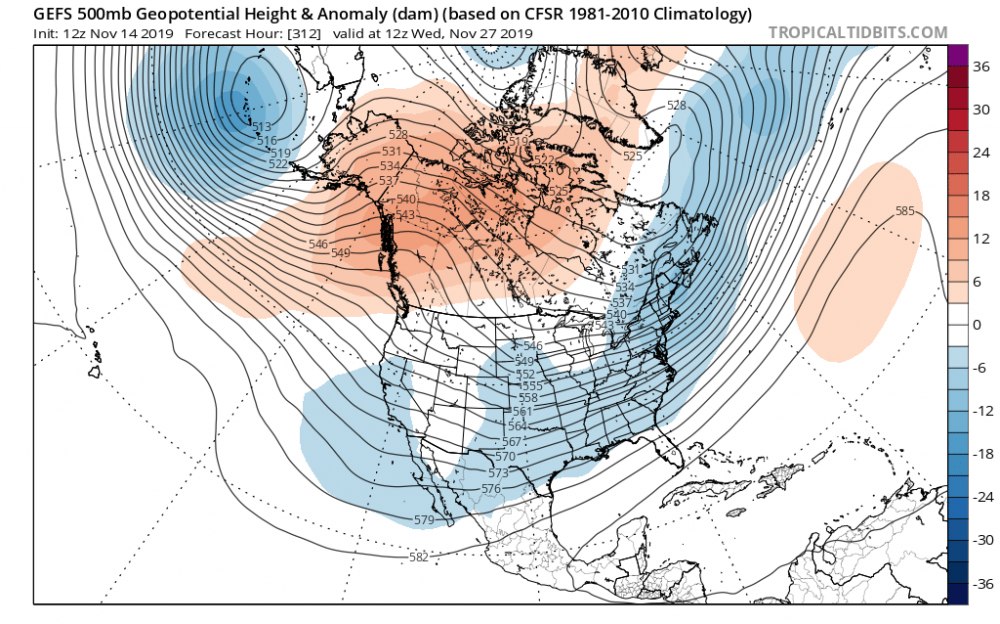
- 574 replies
-
- 1
-
-
- early winter
- leaves changing
- (and 3 more)
-
11/12/19 Tennessee Valley Early Winter Event
tnweathernut replied to BlunderStorm's topic in Tennessee Valley
Looks like about .75 to an 1 inch in spots around north Johnson City. This was a good tune up for what will hopefully come later (and often). Looks to be one band just to my northwest with a nice little max in it. Guessing if you are under that you are watching a bunch of fatties fall from the sky. Congrats to all who saw at least SOME snow! Throw an extra log on the fire tonight and another blanket on the bed............ -
11/12/19 Tennessee Valley Early Winter Event
tnweathernut replied to BlunderStorm's topic in Tennessee Valley
Awesome to have your insight. Looking forward to watching the afternoon and evening modeling roll in and also seeing if this system has a trick or two up its sleeve tomorrow morning. -
I wouldn't discount the Euro snow map from Holston above. It does display a relative snow hole over my house in Washington County of northeast TN. This is likely more accurate than anyone realizes. lol
-
Tennessee Valley 2019 Fall Speculation/Forecasting
tnweathernut replied to AMZ8990's topic in Tennessee Valley
Well, that's great. Glad I could post without checking first..... lol Per the 12z Euro, the Friday night games in middle Tennessee (north) might stay dry for Friday and the TN SC game might be "workable" too, with some drying and warmer temps ahead of the front. Would probably be breezy and warm in Knoxville if that run comes to fruition.- 574 replies
-
- 2
-
-
- early winter
- leaves changing
- (and 3 more)
-
Tennessee Valley 2019 Fall Speculation/Forecasting
tnweathernut replied to AMZ8990's topic in Tennessee Valley
Definitely leaning toward the non-us modeling. Selfishly I'd like to see it dry for Friday night football and the TN SC game Saturday. Pretty amazing to see the wide spread between the GFS with the system. Heck, the GFS has very limited rains west of I-65. Some of the other modeling has most of the rain much further west.- 574 replies
-
- 1
-
-
- early winter
- leaves changing
- (and 3 more)
-
Tennessee Valley 2019 Fall Speculation/Forecasting
tnweathernut replied to AMZ8990's topic in Tennessee Valley
I don't like pinning all my hope on the setup shown on the overnight Euro. Frontal rains don't excite me and we are WAY too dry currently. We need something tropical out of the gulf to link up with a front. Maybe two or three something tropicals over a 2 week period of time............lol- 574 replies
-
- 2
-
-
- early winter
- leaves changing
- (and 3 more)
-
I don't want any part of early and heavy snows (in October). I'm not superstitious, but I have definitely seen that movie a couple of times before.
-
I just need Tyreek Hill to come back for FF purposes........... is that too much to ask?
-
Mid to Long Term Discussion 2019
tnweathernut replied to Upstate Tiger's topic in Southeastern States
Flurries in early March, after all the LR model teases for the past two months, is equivalent to a kick in the nads. -
Mid to Long Term Discussion 2019
tnweathernut replied to Upstate Tiger's topic in Southeastern States
The 12z EPS has a decent signal for something minor around day 8 and something more significant around day 10.... -
Mid to Long Term Discussion 2019
tnweathernut replied to Upstate Tiger's topic in Southeastern States
Yes, a rip off indeed. We have almost been able to set our watches by the late blooming -NAO’s for the last several years. That said, I feel good if we can get the PAC under control the NAO will follow with plenty of time left here......and especially in your neck of the woods. Also, I have been extremely encouraged with the changes with the LR ensembles. It’s actually been fun to watch the last couple of days, plus it silences the negative nancies for a bit. Not even incremental changes, but pretty dramatic which tells me the looks we see the next few days may get better even quicker. The OP’s were throwing hints for a couple of runs before the ensembles started changing. One of the few times that will happen. All in all we should have some good times ahead. -
Mid to Long Term Discussion 2019
tnweathernut replied to Upstate Tiger's topic in Southeastern States
We usually find a strong -NAO, but we usually wait till late March and April to pull it off. haha -
Mid to Long Term Discussion 2019
tnweathernut replied to Upstate Tiger's topic in Southeastern States
Good luck over that way to our coastal folks. I concur, trends are encouraging for a surprise. Doesn’t mean it has to, but it is getting closer and closer with a little time left to go. -
Mid to Long Term Discussion 2019
tnweathernut replied to Upstate Tiger's topic in Southeastern States
You see it time and time again. The heavy snows tend to take people off the roads before the event, but the quick light hitters with plummeting temps usually create an ice skating rink that jam up roads with stuck and wrecked cars. I hope that doesn't happen, but it's certainly on the table after looking at 12z modeling. Hopefully, if this look holds the news organizations will do a good job preparing drivers. -
Mid to Long Term Discussion 2019
tnweathernut replied to Upstate Tiger's topic in Southeastern States
Agree, great post! -
Mid to Long Term Discussion 2019
tnweathernut replied to Upstate Tiger's topic in Southeastern States
I can vouch. Very heavy radar echos with just enough evap cooling in Johnson City and surrounding areas to turn us to snow and produce the largest snowflakes I have seen since 1998. Some were the size of the bottom of a water bottle. Picked up a quick 1/2-1 inch that was not on the radar of meteorologists. Melted quickly after the precip stopped, but heavy daytime snow is always fun regardless of whether it sticks around or not.