tnweathernut
-
Posts
4,746 -
Joined
-
Last visited
Content Type
Profiles
Blogs
Forums
American Weather
Media Demo
Store
Gallery
Everything posted by tnweathernut
-

December/January 2019/20 Winter Speculation Thread
tnweathernut replied to AMZ8990's topic in Tennessee Valley
It’s probable what transpires over the next week (assuming the -EPO has merit) will give a much better idea where the EPO will be. Trends the next week or so will show which form the EPO takes (east vs west). Again, if it’s an accurate depiction about where we are headed....... Glad to see the SOI really tanking the last couple of days. -
Merry Christmas to the best weather people in the best sub-forum on the best weather forum on the Internet... Hope you guys/gals have a GREAT day!
-
December/January 2019/20 Winter Speculation Thread
tnweathernut replied to AMZ8990's topic in Tennessee Valley
Not trying to throw shade at all the MJO discussion. In fact, I have enjoyed reading the forum this AM and in past days....... but..... Are we sure the MJO is driving this bus? I’m not sure I remember a time where the MJO signal and forecasts were all over the place. They are mostly in and around the COD or in low amplitude.... Where the convection increases/sustains, and where it fades in the coming days will likely cause more forecast changes in the near term. Maybe we will soon start to get a more consistent MJO forecast and better consistency wrt sensible weather impacts along with it (for better or worse - colder or warmer). I just wonder if we aren’t missing something else of equal or greater importance? -
December/January 2019/20 Winter Speculation Thread
tnweathernut replied to AMZ8990's topic in Tennessee Valley
Euro LR seems to revert to something less than desirable, but the day 10-12 look is pretty good. It shows how something can be squeezed in this time of year when a front-running system cuts into the northern plains/great lakes and another piece following should be forced further south. Trusting modeling beyond day 4 is not a good idea, but at least it's active. -
For those with Tapatalk, have they worked out all their kinks? I had it for a while and loved it, but then they made changes which caused me to delete it. Just wondering what the user experience is like now?
-
December/January 2019/20 Winter Speculation Thread
tnweathernut replied to AMZ8990's topic in Tennessee Valley
Morning SOI update. The SOI is at -14.38. 10 straight days of negative departures. -
December/January 2019/20 Winter Speculation Thread
tnweathernut replied to AMZ8990's topic in Tennessee Valley
Good posts the last couple of days from everyone. @Holston_River_Rambler, man, you have been putting in some work and @Carvers Gap bringing the heat, literally. lol My non-scientific analysis is below. “It’s always darkest before the dawn” ”Just because you hit rock bottom, doesn’t mean you have to stay there” its all I got ........other than it’s still only Dec 19th. Plenty of time left to realize a good winter. Wall to wall cold isn’t a staple of winters in the mid-south and false starts are what we seem to do best. My glass is still half full, even though it does look like someone took an extra sip or two from it the last 24-48 hours. Hang in there winter lovers, we will flip the script before too much longer..... -
and a couple of more just a few weeks later.... lol
-
December/January 2019/20 Winter Speculation Thread
tnweathernut replied to AMZ8990's topic in Tennessee Valley
Go ahead and jump if you want, but the winter bus will be firing soon. Too much pessimism for Dec 16th. Might be because of last year........ but the SST’s in the Pacific are not the same as last year and the SOI was solidly negative again today. Once the MJO interference subsides I think you will see modeling react in a positive way. Until then, enjoy time with family and a warmish Christmas. -
December/January 2019/20 Winter Speculation Thread
tnweathernut replied to AMZ8990's topic in Tennessee Valley
The only weather stocks I am buying currently is variability and moisture. No prolonged cold, no prolonged warm. We are into mid December and we have had three winter events to track. We have also seen a couple of -NAO’s (one realized, one upcoming on modeling). Unlike many years in the past decade this has felt like a fairly normal start to a winter season. Heck, several even got to enjoy post frontal snow, almost a weather unicorn these days. I think it’s only a matter of time before one of these variable looks offers another chance to track. Much below average temps, as we head deeper into winter, aren’t needed to get it done. Hope everyone has a good weekend....... -
December/January 2019/20 Winter Speculation Thread
tnweathernut replied to AMZ8990's topic in Tennessee Valley
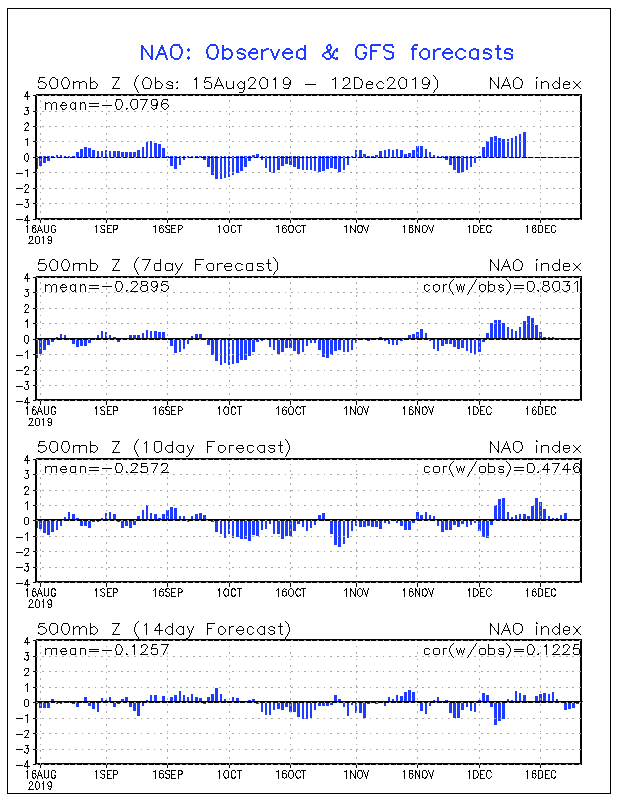
The weak -NAO shown in charts for day 6 is actually a well placed west based -NAO. Sometimes we can look at the chart and see average, but the actual look at 500 can be MUCH better. I have attached the chart to show day 7 (basically neutral in the NAO domain), but the 500 map seems to show a robust west based -NAO. It's kind of like looking at the MJO and noticing the convection doesn't really jive with modeling at times.
-
12/10-11/19 Potential Valley Wide Snow Event.
tnweathernut replied to John1122's topic in Tennessee Valley
Approximately 1" in north Johnson City. Glad some of you guys to our west saw some snow and hope those that got blanked can score a nice one later on this year. I am happy we have had 3 events to track before Christmas. We may end up having a not so great winter, but it sure doesn't feel that way at the moment.- 486 replies
-
- 2
-

-
- snow
- rain to snow
- (and 2 more)
-
12/10-11/19 Potential Valley Wide Snow Event.
tnweathernut replied to John1122's topic in Tennessee Valley
moderate to heavy snow in north Johnson City. Ground already whitening up....- 486 replies
-
- 3
-

-
-
- snow
- rain to snow
- (and 2 more)
-
December/January 2019/20 Winter Speculation Thread
tnweathernut replied to AMZ8990's topic in Tennessee Valley
The 12z Euro is turning to a -NAO. Really close call at 144 now for winter weather in the mid-south. Should the Atlantic break the way shown i won't be surprised if we have another threat to track by the end of the week... -
meh, less than 2 feet in my back yard. I will pass............. lol
-
December/January 2019/20 Winter Speculation Thread
tnweathernut replied to AMZ8990's topic in Tennessee Valley
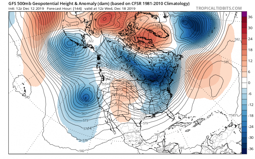
What will ultimately decide how far south the system at 144 can go will go will be the system in the north Atlantic around day 6. The 0z GFS from last night shows a legit evolution to what would be needed to force systems coming through the plains further south. The storm in the north Atlantic created a brief west based -NAO while also providing a slightly displaced 50/50. That made it tough for the plains system to gain latitude. 6z backed off this evolution for the storm in the north Atlantic, but it's not impossible to see this trend more positively in the coming days. Looks like the Pacific will go to poo poo for a bit, but my guess is we are just re-shuffling a bit and nothing will hit and hold through the end of the year and into next. -
12/10-11/19 Potential Valley Wide Snow Event.
tnweathernut replied to John1122's topic in Tennessee Valley
Watch where these enhancements form to our southwest. They are generally modeled to hold together in their trek northeast. Get under one of those and you will be ripping fatties for 30 minutes, give or take. Good luck to those west of us. I hope the precip continues to overperform vs what is initialized in modeling and some of you out that way can get a surprise or two.....- 486 replies
-
- 5
-
-

-
- snow
- rain to snow
- (and 2 more)
-
12/10-11/19 Potential Valley Wide Snow Event.
tnweathernut replied to John1122's topic in Tennessee Valley
No doubt, John. The RGEM struggles sometimes on the back end of a run, but I’ve also seen it win a battle or two. Will be interesting to see how this one plays out. -
12/10-11/19 Potential Valley Wide Snow Event.
tnweathernut replied to John1122's topic in Tennessee Valley
https://www.tropicaltidbits.com/analysis/models/?model=rgem®ion=seus&pkg=mslp_pcpn_frzn&runtime=2019120900&fh=48 accumulations https://www.tropicaltidbits.com/analysis/models/?model=rgem®ion=seus&pkg=asnow&runtime=2019120900&fh=48 -
12/10-11/19 Potential Valley Wide Snow Event.
tnweathernut replied to John1122's topic in Tennessee Valley
The 0z RGEM was a plastering of snow (5-8”) from Memphis, through Jackson and into northern middle TN. Only goes to 48 and is still snowing in these locations at the end of its run.- 486 replies
-
- 2
-
-
- snow
- rain to snow
- (and 2 more)
-
I woke up and saw 14 and thought man, the Euro must have thrown a bone last night..... nope. lol
-
December/January 2019/20 Winter Speculation Thread
tnweathernut replied to AMZ8990's topic in Tennessee Valley
The Canadian snow map is pretty, eh? -
December/January 2019/20 Winter Speculation Thread
tnweathernut replied to AMZ8990's topic in Tennessee Valley
Modeling (euro/gfs) is generally doing a pretty good job from 144 hours out it appears. Just toggling back through prior runs and they look to be generally accurate (placement of high to the north and low to the south) for the system projected through here in the next day or so. I did notice a bit too much progression in the southern branch from the GFS and both look to miss the strength of the high pressure by several MB (1035 to 1037 from 6 days out, now projected to be 1030 to 1032) I also noted the western ridge backing just a bit on modeling, especially the GFS. Just a few things to watch as the 12z runs come in. This run of the GFS already has fairly sizable changes from 6z at 500.... -
December/January 2019/20 Winter Speculation Thread
tnweathernut replied to AMZ8990's topic in Tennessee Valley
Yeah, and that wedge would not erode as quickly as modeled. Would be a major winter storm in the CAD areas as portrayed. Now is the threat real, who knows? It does make sense to see something like that with what’s going on at 500. -
December/January 2019/20 Winter Speculation Thread
tnweathernut replied to AMZ8990's topic in Tennessee Valley
Sure looks like it. If there was something to hold that (1040+) high in place it would have shown a big winter storm. With the high moving at such a fast speed any winter chances would rely solely on perfect timing. That is usually pretty hard to come by. There does appear to be an open window of opportunity though. Maybe we can luck into something? The southern stream just keeps sending moisture at us...... Also, not that it’s worth talking about day 10+, but the Euro at 12z appears to be setting up for a doozy of a storm just beyond hour 240. Surface reflection in the central gulf and energy and cold diving in to capture it. It’s always fun to imagine the possibilities!