tnweathernut
-
Posts
4,746 -
Joined
-
Last visited
Content Type
Profiles
Blogs
Forums
American Weather
Media Demo
Store
Gallery
Everything posted by tnweathernut
-

December 2020 Medium/Long Term Pattern Discussion.
tnweathernut replied to John1122's topic in Tennessee Valley
Mountain snows would be huge if this plays out as shown on the 0z GFS. -
December 2020 Medium/Long Term Pattern Discussion.
tnweathernut replied to John1122's topic in Tennessee Valley
Crazy. Looks like 1950 all over again, just a bit further north... -
December 2020 Medium/Long Term Pattern Discussion.
tnweathernut replied to John1122's topic in Tennessee Valley
There is more interaction between the northern branch and southern branch, and with that “dance” a further west solution. -
December 2020 Medium/Long Term Pattern Discussion.
tnweathernut replied to John1122's topic in Tennessee Valley
I’m just mainly looking for trends at 500. Feels good to be back tracking something with the crew....... -
December 2020 Medium/Long Term Pattern Discussion.
tnweathernut replied to John1122's topic in Tennessee Valley
That’s bold wording from MRX, for a system this far away. Generally they are extremely conservative, sometimes even as inches of snow are falling around the region. -
December 2020 Medium/Long Term Pattern Discussion.
tnweathernut replied to John1122's topic in Tennessee Valley
Other than looking great as you mention, I also like the part about moisture gathering again to our SW at the end of the run......... -
December 2020 Medium/Long Term Pattern Discussion.
tnweathernut replied to John1122's topic in Tennessee Valley
Yeah, lake effect totals would be enormous for some! -
December 2020 Medium/Long Term Pattern Discussion.
tnweathernut replied to John1122's topic in Tennessee Valley
This could be a bias of the Euro as we watch it roll in. Since their last upgrade it has a tendency to over-intensify storm systems. A further west track as a result (as shown on 12z) makes a lot of sense..... Odds of a Miller A are increasing. Likely wet, but the chances for first flakes for some are not out of the question. At the very least it will probably FEEL like winter as early as next week. -
Wild Speculation for Winter 20 -21
tnweathernut replied to Holston_River_Rambler's topic in Tennessee Valley
But is the atmosphere acting like a La Niña? It seems like the actual pattern has been out of phase with El and La more often than not. -
Terrible news. Let us know if we can do anything to help........
-
NAM vs the Euro cage match storm, Feb 20 - 21
tnweathernut replied to Holston_River_Rambler's topic in Tennessee Valley
I thought most areas were supposed to get below freezing tonight (north of 40) Now I see lows in the 34 range. No wonder they are being conservative. If we could make it to around 29-30 it would have a much bigger impact, IMO. -
NAM vs the Euro cage match storm, Feb 20 - 21
tnweathernut replied to Holston_River_Rambler's topic in Tennessee Valley
It looks more marginal than the last system for areas south of 40. North of 40 it seems to be a better profile, but more concerns about amount of precip. As with almost all SE snow possibilities, there are factors for us all to overcome... lol -
NAM vs the Euro cage match storm, Feb 20 - 21
tnweathernut replied to Holston_River_Rambler's topic in Tennessee Valley
Always a concern as to whether it's right or not, but we are in a time period where we are no longer talking about the NAM at LR. At the same time, other modeling has moved steadily toward what the NAM has had all along. It's probably overdone on amounts, but then again............when is it not? -
February/March 2020 Winter's Last Chance Thread
tnweathernut replied to John1122's topic in Tennessee Valley
Yep, totally different from the first few words..... lol nice find........You always amaze me with your records and recollections. You are a great asset to our group!! -
February/March 2020 Winter's Last Chance Thread
tnweathernut replied to John1122's topic in Tennessee Valley
There was a scenario several years back where modeling was not enthused at all about precip into Tennessee. I remember Robert @ WxSouth ended up picking up on the inverted trough and in the end there was a decent snow from it. I can't remember the year, but my recollection tells me the basics were familiar... (i.e. overrunning, inverted trough, no defined low, etc.) Does anyone else remember this event? -
February/March 2020 Winter's Last Chance Thread
tnweathernut replied to John1122's topic in Tennessee Valley
Still not too excited about this one, but the flow has backed a bit over the last several runs on modeling. This is probably oversimplified, but IF we can manage a WSW flow vs ESE or even W, there's at least a chance for more generous precip. In a nutshell I am hoping for the best, preparing for the worst I guess you'd say. Regarding time, when you see "Z" time, just subtract 5 hours to get to actual time in the EST zone, and subtract 6 hours in the CST zone. -
February/March 2020 Winter's Last Chance Thread
tnweathernut replied to John1122's topic in Tennessee Valley
9 times out of 10 these setups will produce precip much further north than being modeled 3-4 days out... that said, 500mb is a hot mess on most modeling, including the 12z Euro OP (i.e. we likely find the 1 out of 10). -
Southeast Valley Special Obs and Last Min Forecasts.
tnweathernut replied to John1122's topic in Tennessee Valley
Congrats to our SE mid-south forum peeps. This is awesome. Congrats and enjoy! -
Would be nice if we can also get a couple of those TD's that followed............ haha
-
Andre Michaux Feb 1796 analogue Storm
tnweathernut replied to Holston_River_Rambler's topic in Tennessee Valley
Good luck to all out to my west. Hope there are some pleasant surprises out y’all’s way!! -
February/March 2020 Winter's Last Chance Thread
tnweathernut replied to John1122's topic in Tennessee Valley
Still pops later, but you are right. At least for this run vs. the past 3, it looks a bit delayed. -
February/March 2020 Winter's Last Chance Thread
tnweathernut replied to John1122's topic in Tennessee Valley
It's been pretty bad........ but the Euro was throwing a solution last night so who knows. Normally, if someone's life depended on the ICON being right from day 8............... I'd tell them to have their family go ahead and prepare their obituary and wish them God speed. -
February/March 2020 Winter's Last Chance Thread
tnweathernut replied to John1122's topic in Tennessee Valley
Banter post......... Looks like a fire breathing monster with ice cold eyes and green hair blowing a torch fest down on the lower 48. On topic, I will remain optimistic with what I am seeing. In order for this to work though, we are going to need to see modeling correct colder at 2M. This is something I can't remember happening in the winter months (D-F) in over 2 years. I am in, until I'm out. -
Is it actually even possible for literally EVERY good feature to be polar opposite (i.e. bad) at day 10 when comparing the GFS and Euro? Asking for a friend.....
-
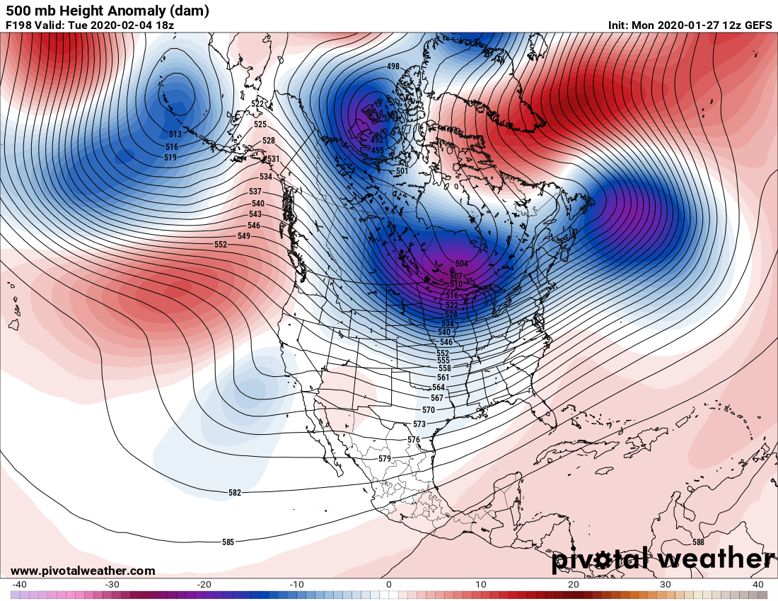
February/March 2020 Winter's Last Chance Thread
tnweathernut replied to John1122's topic in Tennessee Valley
The 12z GEFS seems to really agree with the OP. This is smoothed of course, so it won't match exactly but it checks almost all the boxes for winter in the SE/Mid-South. 1. -NAO, west based 2. 50/50 3. PV in the Great Lakes 4. Southern Stream energy off the CA coast 5. Hints of a - EPO and -AO 6. Aleutian Low Some of these points could be consider marginal or not perfectly placed, but all in all one of the better looking maps you will see at day 8.