-
Posts
4,746 -
Joined
-
Last visited
Content Type
Profiles
Blogs
Forums
American Weather
Media Demo
Store
Gallery
Everything posted by tnweathernut
-
It’s less fun to chase near term systems when there are such swings in modeling this close to an event. Happy for those west of here, but wondering if Kentucky isn’t the true winner when all is said and done (on this side of the Apps)
-
3k (apparently it's lightning quick on Pivotal, lol) agrees with the adjustment as it relates to the trailing energy. Maybe we can get some in west and/or middle on the board with this system. Looking less enthused for east Tennessee.
-
Looked like the trailing ULL energy was more consolidated that run. No clue if it's right, but those north of I-40 in west and middle TN just sat up a bit straighter in their seats. Let's see what the 3k says and the rest of the 18z suite.
-
Parts of west and middle Tennessee will like the happy hour version of the 12k NAM..... Looks like the trailing piece is a touch stronger. East Tennessee will still do well also. Should be a decent snow map
-
I know it's been said, but at least for east Tennessee this winter has been infinitely better than the previous 2 winters. Even for middle and west Tennessee I bet it's had to at least feel like a fairly normal winter to this point.
-
I don't think that kicker racing in from the northwest is doing us any favors, but it does look better at the surface. This system just kind of developed right under our nose, so it's almost a bonus to be discussing winter this weekend.
-
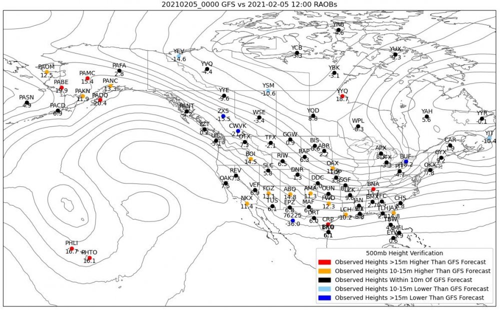
This is a fantastic product put together by Jack Sillin. He is definitely a recommended new follow for TwitterWx peeps. If he can figure out how to automate this product I think it will be a great tool for the toolbox. What this says to me for the Tennessee Valley is there is a chance for more amplification. Increased ridging in Alaska and a more robust (deeper) low coming into the northwest vs the forecast could help this dive a bit more coming into the southern plains, creating a track just to the west or northwest of where it's currently projected and a little stronger than currently projected. Time will tell, but definitely something to watch to see how the globals react to the new data. I wonder if this data was used in the 12z mesoscale models? Since there was a bump back northwest and what looked like the upper level energy being a bit stronger, I'd say it likely was.
-
Well in fairness this might be just an eastern half of TN event, so if I were them I’d wait a cycle or two and casually mention it as a possibility this evening
-
Wonder if Jeff is ready? Chattanooga and an early afternoon start time. This thing already has two strikes against it down that way..... lol
-
Good ole fashion Nam'ing happening at 18z for a good chunk of the state. Seems faster also, starting late afternoon on Saturday.
-
The Euro snow map will look quite localized, but moisture would likely be quite expansive under the setup shown. Let's get through this weekend and then we can start looking for what comes next week. Hopefully the cold will indeed press. It's the biggest ingredient that seems to only want to flirt and tease us so far.
-
So forget what the euro surface is showing in the mid range and look at 500 from hour 168 to 192. See the shortwave in the southwest? It turns the flow across THOUSANDS of miles from the west south west. All the while we get a press from the PV, sending high pressures down the front range of the Rockies. The cold SHOULD press all the way to the Apps. Carvers and I have been talking off the board for several days about a major overrunning event being possible. This is how it would happen, and is exactly what a 500mb map would look like if you were going to get one. This is probably one of the best looks I have seen in a while. Hope we reel it in. If we do, someone in TN and maybe many, will get walloped. .
-
That's how I take it too. The thing is, at our latitude................ really............. the GFS and GFSv16 is about perfect. Nice vort pass, goes negative in a perfect place, and is moisture laden. If it digs more, the storm is likely bigger, but warm air advection likely makes this a Kentucky to Virginia snow storm vs a Tennessee Valley snow storm.
-
Will try to show you what I was looking at. It’s closer than I thought when watching it in real time...... at 500. First the GFS at 30, 54, and 66. The vort looks a little more pronounced than on the Euro. Also, you can see the speed of this rascal. By 66 it’s in a great spot for producing precip across TN and the surface shows that as a nice little snow. Now, the Euro at the same times. Very similar placements wrt timing. Maybe a touch sharper on the American modeling which likely accounts for more snow shown. Threat looks legit, congrats to the GFSv16, which has had this for a couple of days now. .
-
Out to 30, the energy coming at us is much stronger on the GFS in Idaho vs. the Euro. Yes, Idaho. This is the piece of energy that is set to make it to northeast TN in 42 hours. This thing is SCOOTING! I will say the energy is a tad more prominent than on the 0z Euro. Still doesn't look anything like the American modeling suite.


