

tnweathernut
-
Posts
4,746 -
Joined
-
Last visited
1 Follower
About tnweathernut

- Birthday April 26
-
Erwin has had a bare ground since 10 this morning. We are in the mid 30's downtown, while areas just to our northwest in and around Johnson City appear to be holding around 31/32
-
The last expansion of precip on radar is occurring over the next hour or so.
-
Dusting in Erwin, around a half inch in north Johnson City when I left the house about 30 minutes ago, but we knew part one was going to be problematic. Congrats to those overperforming! Holding out hope tonight can catch the upslope areas up to the other areas. I'm guessing we wake up to a prettier picture tomorrow than we did today and probably more road problems due to much colder temps.
-
I guess all we can do is hope a small fraction of that can translate downstream.
-
The timing is more important than anything else. Because of the cold, why not focus mainly on that. An early morning start for east and northeast TN will have an impact on travel and schools. That, more than amounts should be the concern. Focus on timing. It will be cold enough for problems, that much we know.
-
IMO, classic case of MRX overthinking things and trying to be too cute. They don't really even have to go out on that limb right now, so why do it? Just go with a general 1-3" and fine tune it tomorrow morning. Getting into this fine of detail 48 hours in advance of a .1-.3 QPF system is silly and drives me nuts.
-
All kidding (kinda) aside, a pretty good pass and the second best chance at a widespread winter event are looking increasingly likely.
-
Winter, decade, quarter-century….. been a pretty consistent feature for the better part of the last 25 years. Almost as consistent as a SE wind off the mountain when it’s cold enough for snow everywhere but along the base of the Apps. lol
-
Looks like the euro won this battle. We didn’t score as much with the snow and ice (what’s new), but we didn’t totally blank either. Pretty much all of TN saw at least some snow. With the EPS/GPS showing the way back toward something workable around mid February, while the GFS charts its own way…… guessing the GFS will be 0-2 here in a couple of weeks.
-
If you got downsloped with this last system in northeast TN, and you’ve seen several runs of the CMC tease SE/far east TN with next weeks system, you’d be ok with a bit of a northwest trend and a shot at a light snow event. Im guessing these guys/gals are willing to sacrifice historic gulf coast snow for it. Pretty sure those guys moved down there so they wouldn’t see snow anyway……. lol Besides, when was the last time Jeff scored twice in a 10 day period??
-
 I mean, it’s not like the last 6 runs of the GFS is staying put…….there is a definite trend at the surface. Looking at 500 there’s a limit how far north and west this can make it, but getting scraped isn’t out of the question for some, IMO.
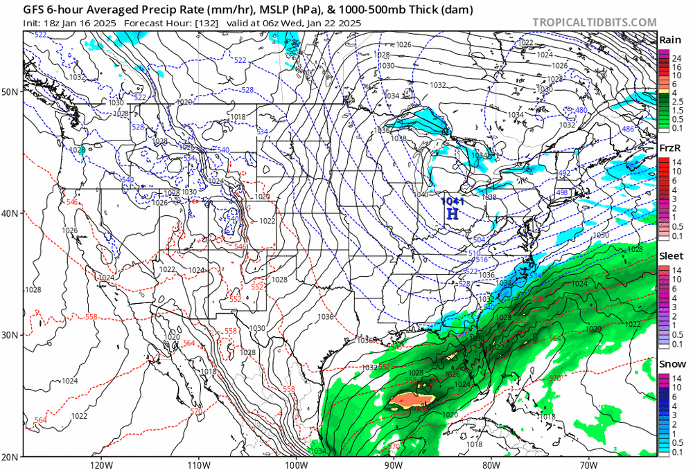
- 207 replies
-
- 3
-

-

-
- obs
- light snow
- (and 2 more)
-
Sounds like we need to put the once reliable Euro on Prozac...
-
I specifically had you in mind when I made the post…… lol
-
Was just thinking about that yesterday. In the "snowless" 90's northeast TN saw three separate foot plus events. Not once since I can recall. Pretty crazy.
-
Wasn't it several years ago when the gulf coast states did pretty well when our area couldn't buy a snow? Maybe back in the mid 20 teens? I agree this has deep south and Carolinas written all over it. Would be nice to see our new poster in east central MS get pounded. Unless they are a Lane Kiffin fan and then in that case, 33 and rain. I kid, I kid. :-)


