

ariof
-
Posts
524 -
Joined
-
Last visited
Content Type
Profiles
Blogs
Forums
American Weather
Media Demo
Store
Gallery
Everything posted by ariof
-
There's a Herman Cain (RIP) low at 156.

-
Last three runs have taken the low from ALB->BAF->ACK By tomorrow this will be halfway to tracking over BDA.
-
Oh honey, I certainly do. But that's why there's a banter thread. It's even pinned! I would like to see what someone thinks about the 00Z GFS thinks about the next wave flattening out. One run of the Euro paints an ice storm and all of the sudden everyone is comparing the length of their extension cords.
-
Can we maybe move the generator talk off to banter pls?
-
December 5-6, 2020 Storm Observations and Nowcast
ariof replied to Baroclinic Zone's topic in New England
I've been doing this for years. It's quite accurate! -
Dec 5/6th major coastal/ west Atlantic cyclogenesis ...?
ariof replied to Typhoon Tip's topic in New England
63 at BOX the day before April Fools 1997. 61 at PVD, 62 MQE, 63 BDL, 54 at ORH. -
Dec 5/6th major coastal/ west Atlantic cyclogenesis ...?
ariof replied to Typhoon Tip's topic in New England
Tolland! Drink! -
Dec 5/6th major coastal/ west Atlantic cyclogenesis ...?
ariof replied to Typhoon Tip's topic in New England
Loved this storm! I was on a cub scout overnight at the Museum of Science! They woke us up on the intercom at 6:45 with "good morning campers, it's snowing outside" and indeed it was. The morning activities were called off and everyone piled in to go home. We only had to make it a few exits out the Pike; not sure if there were folks from ORH county and how they fared! -
Dec 5/6th major coastal/ west Atlantic cyclogenesis ...?
ariof replied to Typhoon Tip's topic in New England
My favorite too! Sunday 3/30: 63˚, biking in shorts. Prediction of 10-14 overnight Monday which no one believed. Monday 3/31: 45˚ and raining in the morning 8 SM W of KBOS. Prediction of a flip between 4 and 6. 1030 math class, bored looking out the window at the rain. Look back at the board. Look back out the window and I couldn't see across the field. My middle school math teacher did not care for my weather report. 1400: All after school activities canceled. Our bus driver usually left the door open and had to be woken up when it was time to leave but had to open and close it for everyone getting on to keep the blizzard out of the bus. With all activities canceled, we had about 80 people on the bus, sitting on laps. Barely made it up a couple of hills. No school Tue-Wed, since many streets hadn't been touched. -
When was the last time that "big ice" south of Route 2 verified?
-
Given the trends this winter, this will be over EEN by tomorrow and SLK by Thursday.
-
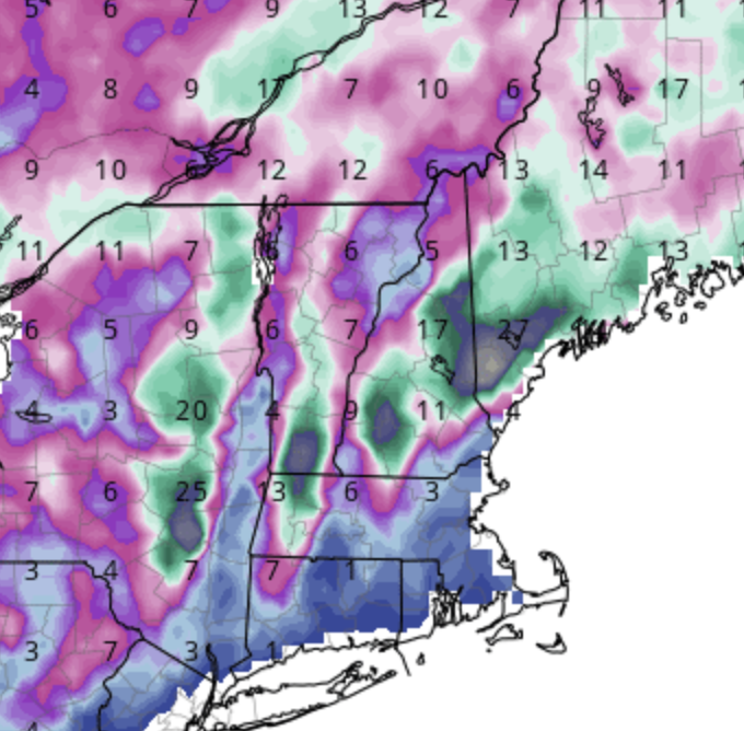
GFS clown range maps showing the second storm almost identical to the first. 2'+ from DDH-AFN-CON-GYX, but basically zilch 1V4-HIE
-
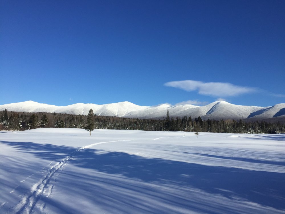
Just as good up close! Great day for an xc ski race. Maybe got to 15 in the sun. Was tempted to throw on traction and run up to the ridge but, uh, -40 wc didn’t sound fun at all.
-
Period of record for BOS (1873 to present) shows 92 days >= 60 degrees in January. So an average of about 0.6 per year. Max of 5 in 1950, a month which was +7.2, with 64 on the 4th, 61 on the 5th, 63 on the 14th, 72 on the 26th and 62 on the 29th. There was a freeze in between each of these (other than the 4th-5th, obviously) so in a sense five major January thaws that month. The 72 is really most impressive: lows were 24 and 21 the days before and after. (It wasn't a January thaw, but my most memorable thaw is probably the -9 on 14-Feb-16 and 54 on 16-Feb-16. The -9 was the coldest temperature at KBOS in six decades and a -30 anomaly, two days later it was 54 and a +10.
-
Winter 2020 New England Banter and General Obs
ariof replied to CapturedNature's topic in New England
Nice little squall just passed over 1SM W of KBOS (so, Downtown Boston). Vis <1SM, swirling snow, and white on all the rooftops. Fun to watch from the 16th floor with a view to the west. Fun timelapse: -
Or 2014-2015. Dec 22-29 at BOS had four days in the 40s and four days in the 50s and felt like spring. Jan turned cold by the 5th or so, but still had a day where BOS hit 50 mid-month. It was only Jan 20 that BOS fell below 40 for that 45 day stretch until March 4 (which is the longest on record, IIRC) and then only slowly crept up into the 50s (only four days in the 50s in March, which is basically the same pattern with a lot more sun). But that is absolutely the exception, and given that patterns usually last a significantly shorter time, a few days in the 40s or 50s should be expected in January. Checking out the NOW data, there have been 21 Januarys where the temperature has stayed below 50 for the entire month since 1872. So one out of every 7-8 years doesn't have a thaw that breaks 50. As for months that stay below 40, that's happened twice: Jan, 1875 and Feb, 2015.
-
2SM w of KBOS visibility now down to 3/4SM. I can just barely make out the Ritz, but can't see the recently-steady red old Hancock.
-
New office has a nice view due west down the Charles. Can estimate visibility by how far I can see. -SN started about 30 mins ago with vis to Mount Ida in Newton Corner (7SM). Now out to the BU Bridge (3SM) Productivity is going to go down the tubes during any events.
-
And now -RA. Right on the line here.
-
Back to -SN in Cambridgeport, sometimes more RASN.
-
Went on a run. On the Harvard Bridge the winds were ENE (and strong, tasting the salt in the air), but out by River Street more northerly. Looks like the coastal front is sitting right over Downtown right now.
-
Mitch is reporting 5"/hr, total of 15.6 and counting. I wonder if he'll eclipse the 31" in Bayfield County, Wis, which is the highest report I've seen for this storm east of the Rockies/Sierra.
-
On D10 the GFS and Euro both have KBOS at 60F. Clown range, but still no bueno.
-
RA here in Cambridge. Google maps traffic shows that the rain/snow line is about a mile west.
-
Can confirm. Valleys definitely colder than hills. XC skied at 6:30 from 1100' to 900' in Craftsbury and the temperature must have dropped by 5 degrees. And it was 0 at the top …


