ariof
-
Posts
674 -
Joined
-
Last visited
Content Type
Profiles
Blogs
Forums
American Weather
Media Demo
Store
Gallery
Everything posted by ariof
-
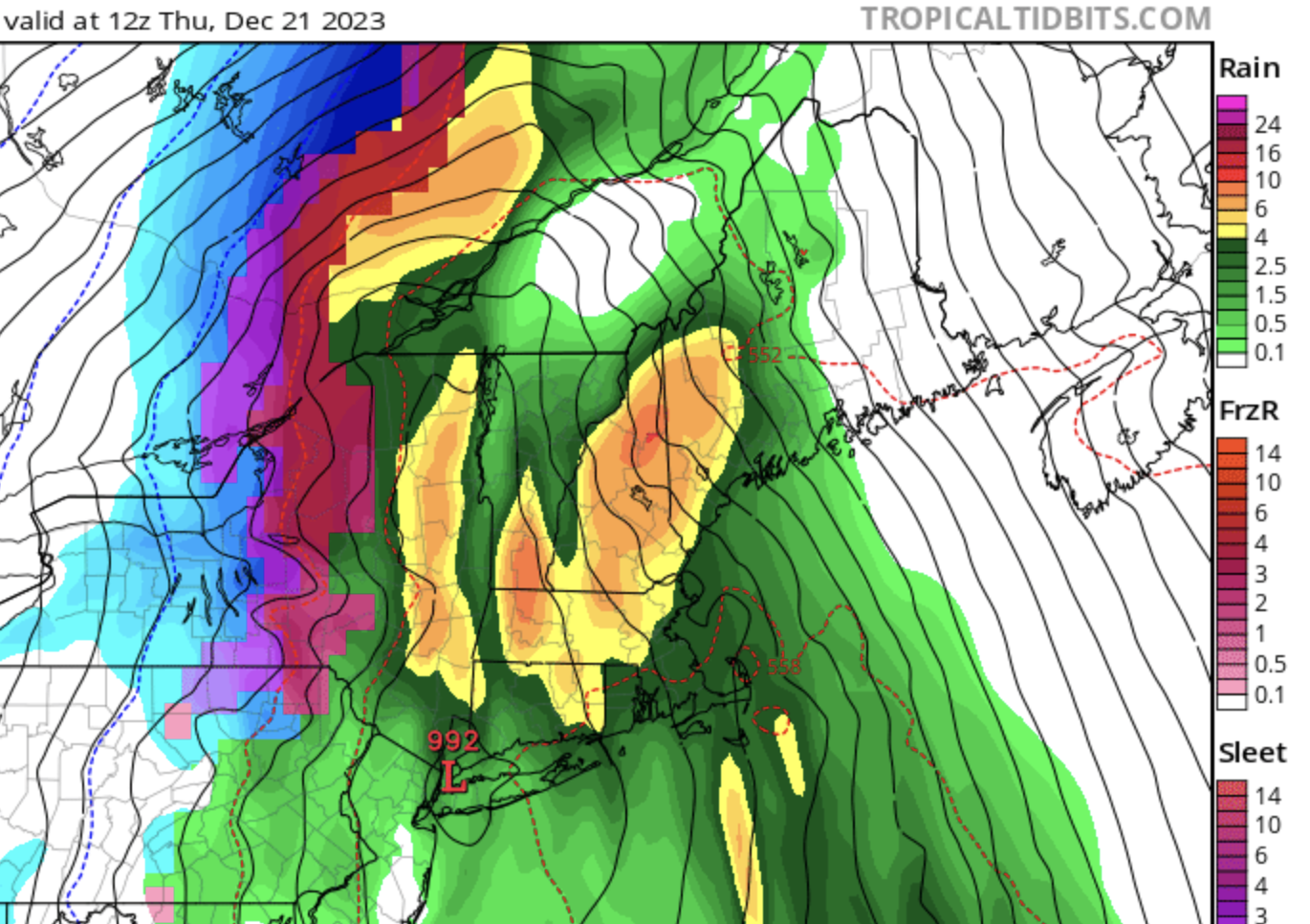
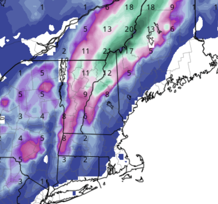
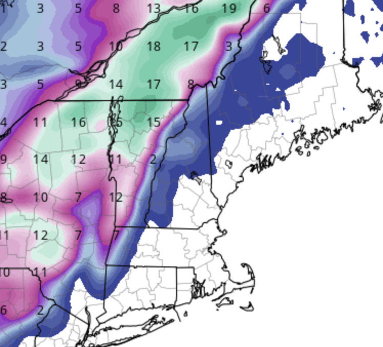
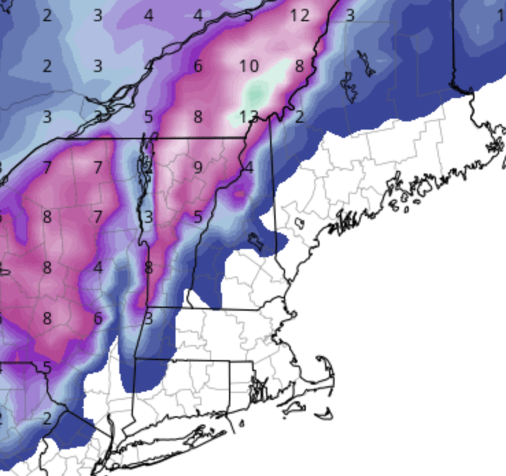
GFS not buying the NAM. CMC sort of splits the difference. GFS max NNE snowfall over the Whites and along the border north of that. Skunks the Dacks and Eastern Twps. NAM max NNE snowfall northern Greens, nothing in the Whites. Nails everything east of the St Lawrence. CMC lower max but hits the Conn Valley and the Whites somewhat. Sort of splits the difference.
-
Good thing the Canadian doesn't have the same—oh, wait. The GFS tries to save it with a last minute offshore redevelopment, I guess?
-
Ha! Well the PO Box for Pinkham is in Gorham but the ravine is in Sargent's Purchase.
-
From the GYX PNS … impressive that Gorham had 8" of snow and Pinkham nothing. Usually it is the other way around. ...Coos County... Gorham 8.0 in 0530 AM 11/27 COOP Carroll 4.6 NE 2.5 in 0700 AM 11/27 COCORAHS Pittsburg 2.0 in 0700 AM 11/27 COOP Jefferson 1 W 1.3 in 0700 AM 11/27 COOP Lancaster 0.5 N 1.0 in 0600 AM 11/27 COCORAHS Whitefield 1.0 in 0710 AM 11/27 Trained Spotter Northumberland 0.5 in 0835 AM 11/27 COOP Pinkham Notch 0.2 in 0545 AM 11/27 COOP
-
Any chance this next storm CADs decently? The Euro looks good for the Greens/NEK and near the Notches.
-
-
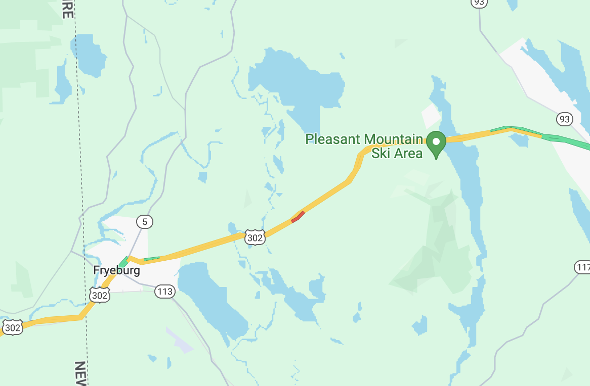
Per the Google Maps rain/snow line AI generator: Yes.

-
Must be fun to drive down the notch and drop 1000' in elevation and at some point run into a wall of snow (this is Attitrash's cam)
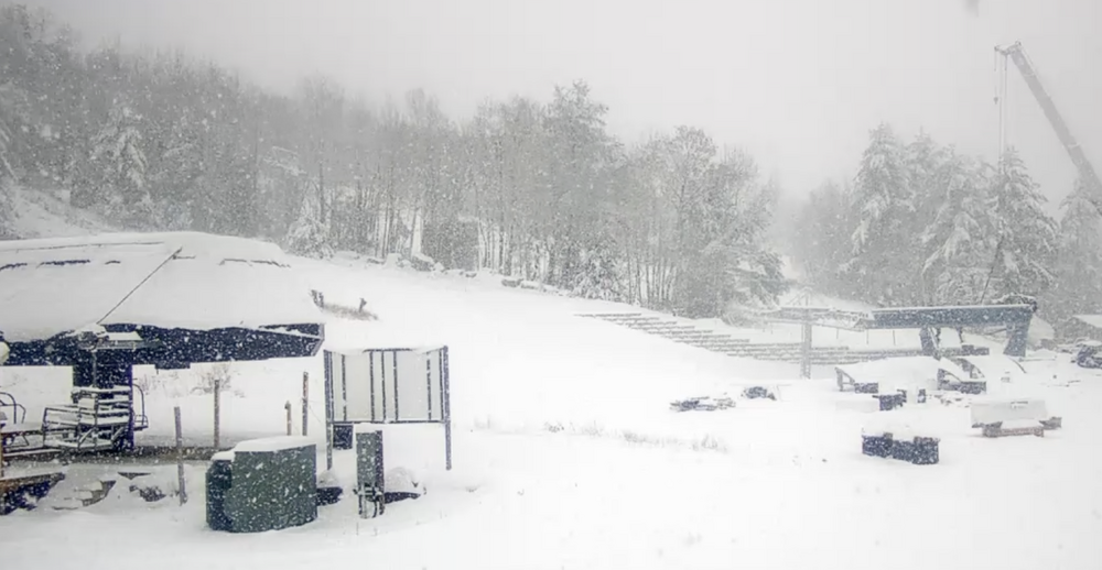
-
They report 6-8" and that's before the current round of puking. Quite the returns right now up there and seems to be snow. North Conway has a webcam, too.
-
Here's to hoping! HIE 39, IZG 33. Given the reflectivity moving through there, Jackson et al are probably doing quite well. This is the Cranmore webcam called "snowing" and yes it appears to be doing so!
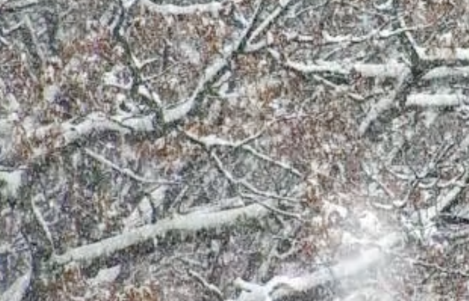
-
You can see the easterly winds downslopiing off the mountains. The west side of the Whites often winds up with less and the valleys east of the mountains can do quite well.
-
Near KMWN similar. 27-29 at stations in the valley. 41 up the hill. MW Obs reports 45 at 1600, 40 at 2300, 46 at 3000 and 4000, 41 at 5200 and 36 at the summit.
-
get it out of the way in Nov.
-
And … just like that their FB page shows them making snow. Not sure if that were last night or tonight, but if they blew last night, they're def blowing tonight.
-
Unclear whether Wawa has been putting out snow last night / tonight. Should be cold enough, but they might be looking at next week and figuring it would just wind up back in the pond before they could get a weekend day out of it.
-
Radiation? I know MVY can radiate quite well.
-
Maybe the grinch will come early this year. (I know, I know, he'll be right on schedule.)
-
Wishing a happy Model-Runs-Come-Out-An-Hour-Earlier Day to all who celebrate. [Which is probably just this forum, but still]
-
NAM says enjoy a breezy, dry Saturday.
-
I have a vested interest on the weather on Monday between Hopkinton and BOS, starting a thread here in case anyone else wants to discuss. BOX says: Sunday appears to be the transitioning point towards more unsettled weather as a robust cutoff low approaches from the southwest. At this time, it appears that this low will pass well to our northwest over the Great Lakes region , but an associated cold front may bring the first chance for appreciable rain to the region during the late Sunday-early Monday timeframe. That seems reasonable and has ensemble guidance, although models are now suggesting the fropa might get held back. The big question is the timing. If the fropa is on Sunday afternoon or evening, it could lead to a mild-but-not-hot, dry, and breezy (with a tailwind!) marathon. (April has the most easterly winds of any month in BOS, which of course the marathon often tries to run into). Slower evolution of the big ULL may allow a backdoor cold front to push in from the coast and keep it cool (the GFS and Canadian have this on Saturday afternoon). If it doesn't, though, a more SWerly flow could push warmer temperatures in, and then there could always be rain (although maybe not 2018-level biblical flood rain) as the 12Z Canadian shows (but rain and cooler temperatures than the GFS). The latest GFS has a slower fropa with warmer, muggier conditions on Monday overwhelming the NE surface flow during the race and the fropa not until Monday evening, while at another extreme 18Z last night it was a faster fropa with strong WSW tailwinds (cough 2011 cough). With Eliud Kipchoge running, that could lead to a course record and perhaps close to the two hour barrier, which has never been done without pacers (although it wouldn't count as a world record because the Boston course is downhill and too straight). Anyway, I'm hoping for 52, cloudy, with a W-WSWerly breeze (really WSW shifting WNW right around when I make the turn by the firehouse in Newton) but I'll have to follow the model evolution for the next few days.
-
Checking the snowfall at Pinkham Notch on xmACIS which has data back to 1930 (thanks, Joe). Data isn't perfect but is pretty good. Their highest year was 1968-1969 with 323" which may never be touched including 160" from Feb 4 to March 5. This year was BN through January, on Jan 21 it was at 52" (9" BN). Since then, ~150" has brought it to 8th overall, and 4th highest for this day. If the models are to be believed, it will be third overall within the next couple of weeks, trailing only '69 an '58. You wouldn't know it 100 miles south, but they're having a snowy winter up there even if it's warm. Tucks might ski well into May this year!
-
2020 and 2022 yes, but 2021 was wet (especially down in SNE but even up north).
-
Yankee Publishing has a webcam which takes a static image every hour. They've been in the pivot firehose since the storm started at 1600', I assume they're north of 24" by now. Here's a GIF of the storm (missing the image from 0700).
-
Meanwhile Mount Snow is reporting 34"