

ariof
-
Posts
674 -
Joined
-
Last visited
About ariof

Recent Profile Visitors
3,084 profile views


-
Are the NAM thermals onto a sliver of SN+ over SNE tomorrow morning? Are some folks going to wake up surprised to see some springtime paste before the #sunangle gets to work? Or are they back smoking something?
-
Not to the Fairbanks extreme for, like, mid-January, but pretty darned cold for March. FAI is currently sitting at -15.5° for March. The previous coldest March was -6.6°. The next week will be warmer, with an average around 0, but they should still wind up around -10 for the month, which will easily be their coldest month on record. And that was after their coldest December since 1980, and cold Jan and Feb, so their DJFM will be anomalies of -19, -6, -7 and -20. Plus a lot of snow, they were already above average and Feb dropped 39" (their average is 10"). They should be in the top 10 years with >30" of snow depth (48 days as of yesterday) Pretty deep winter up there. ANC has been warmer until this month, but got 40" of snow in January and this month is running a -15 anomaly. While FAI had one day above average (by like 0.1°) ANC is at like 34 days below average and will add to that for the foreseeable future (they're not progged above freezing for at least a week, and should be at ~ the third longest such streak). And down in Juneau the story is more the snow. 82" in a -12 Dec (depth of 50") which was gone by Jan 15 after a week of rain, but 28" in Feb and 52" so far this month and they're sitting at 184" for the year, 10" off the record, and they should be close by the end of next week. This guy's feed is a pretty good compendium of how cold it has been up there this winter. (Things like "Juneau has had more snow than Fairbanks and Anchorage combined, and both of them are above their averages.")
-
18Z DGEX!
-
Quite the CAD in the lee of the Whites. 41˚ at KMWN, warmer than anything in basically an Ossipee-Bridgton-Crawfords triangle. Although anyone over about 1000' AMSL is warmer. Meanwhile KHIE is 58˚.
-
74° in Boston and the Charles is still frozen. In 2015 when it was frozen a good deal more solid it didn't melt out until April 1. Of course, the first 70+ reading at BOS that year was May 4.
-
First winter with DJF all below 60˚ (although barely, the pre-xmas Gricn hit 59˚ in BOS) since 2013-2014. After Feb 2015 (high of 39˚) every Feb was above 60˚ until last year (53˚) and this year (49˚). I'll take it.
-
Does anyone know why KBOS stopped reporting daily snow depth in the late 1990s? This year would be in the top 10, except the data cuts off around 2000. 1977 and 1978 both had two solid months, and 1994 and 1996 both had 30+ days. I have to assume 2015 would be right near the top of the list. KMQE does have data going back longer, right now is sitting at 46 days, 29th longest. Longer this century: 56 (2001), 70 (2015), 77 (2011), 84 (2003). Record of 100 ending 3/23/1923.
-
HRRR has SEMass (Plymouth and Bristol counties) radiating more than anyone tonight. Soundings for 11Z show 20˚ at the surface and 50˚ juuuust above the surface. Cranberry bog special. TAN and MVY already down to 30˚, OWD at 32˚. Cranberry bog special!
-
That band hitting Boston right when everyone goes out on the road is going to be fun. Kendall Sq is <1 SM already and not even in that band yet.
-
The NE Banana Belt today is BTV to MLT, 10-15° warmer than ORE-EEN area (and warmer than anywhere in SNE). Morch #sunangle doing it's job.
-
DJF with 8.6" of SN at BOS, and monthly anomalies of 4.3, 4.2 and 5.5. That whole winter was Morch.
-
Clipper Fires In Wednesday Feb 25 Disco/ Obs
ariof replied to Damage In Tolland's topic in New England
SN/SN+ in Kendall Square. Viz <1 mi (probably around 3/4 based on which building outlines I can and can't see). -
Clipper Fires In Wednesday Feb 25 Disco/ Obs
ariof replied to Damage In Tolland's topic in New England
Roads in CT look pretty awful, with everyone going back to work and the storm hitting right at rush hour. 2:15 to go 31 miles from Bridgeport to Rye. Ugly.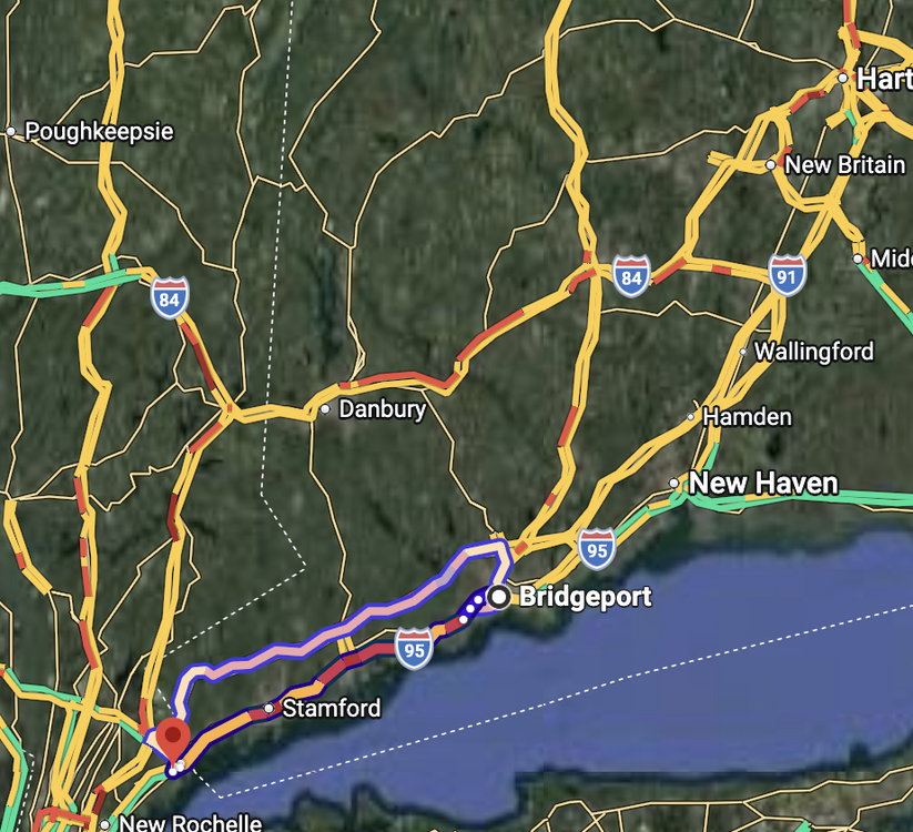
-
Today is day 32 below 42° in Boston in a row. Longer periods: 43 (ending 2015-03-03) 42 (1969-03014) 40 (1936-02-25) 39 (1985-02-09) 37 (1945-02-10) 36 (1981-01-18) 35 (1966-02-09) 35 (1875-02-02) 34 (2011-02-05) 34 (1901-02-25) 33 (2009-01-31) Not a lot of modeling showing it going above 40 in the next week, although the sun angle may start to help.
-
"Don’t do it" 2026 Blizzard obs, updates and pictures.
ariof replied to Ginx snewx's topic in New England
I heard the same thing. 40 is not out of the question!


