Chinook
-
Posts
10,080 -
Joined
-
Last visited
Content Type
Profiles
Blogs
Forums
American Weather
Media Demo
Store
Gallery
Everything posted by Chinook
-
Question: both snowfall with 10-1 snow/liquid ratio with the 4km NAM, 12z run. What is going on with the wiggliness of the Pivotalweather.com depiction of this?
-
Even though the models have trended east/ with more snow into Indiana, it will likely not be a snowstorm for NW Ohio, not of much impact anyway. The surface to 925mb winds should be pretty strong out of the NW- probably lots of gusts over 25mph for open areas, 12z Sunday to 06z Monday, maybe with some steady snow or flurries. I suppose the LES may visit Cleveland. Note: the 06z GFS and the 12z GFS don't quite agree on wind direction after the storm-- perhaps this means more uncertainty for Cleveland LES. 90 hr GFS sounding over western Lake Erie-- potential for 100-200 J/kg of lake-CAPE, winds at 300 degrees NW. (?)
-
One of the cool things available now is the Sharppy soundings directly off of the forecast maps on both College of Dupage and Pivotalweather.com. These could be quite helpful for future lake-effect snow scenarios. College of Dupage web site also allows you to view sounding text after generating a sounding. I was playing around with generating a NAM sounding over Lake Erie tomorrow. Pivotalweather allows soundings from the 4km NAM and HRRR too. Unfortunately it doesn't allow adjustments for warm lake temperatures that are above the 2m temperature.
-
I believe CLE had the 4th warmest November at 48.6 degrees (plus or minus a tenth or so)
-
GFS is showing some strong winds for the middle of Lake Erie. The NWS zone forecast offshore from Cleveland has 27kt gusting to 36kt Saturday. GFS shows 45kt close to the surface (950mb), Saturday, before the cold sector.
-
Keeping the lake warm only helps the snowlovers if there is a cold airmass aloft to create the lake effect snow. Personally, I like walking on a frozen Lake Erie, you know, like 5 feet from the shoreline.
-
NW Ohio and NE Indiana both had a very wet summer compared to average. These areas were among the wettest in the country, considering climate division precipitation rankings. NW Ohio climate division had the record wettest summer. link to NOAA (similar plot) http://www.ncdc.noaa.gov/sotc/service/national/divisionalpcpnrank/201506-201508.gif Summer precipitation in Ohio ranked 114 out of 121 (i.e. it was the 8th wettest summer in 121 years) http://www.ncdc.noaa.gov/sotc/service/national/statewidepcpnrank/201506-201508.gif
-
NWS 4-km precipitation analysis available here (for free) http://models.weatherbell.com/hrap/nws_precip.php shows that Toledo has had 9-11 inches of rain in 30 days (as of a couple of days ago) and Cleveland has had 9-13 inches. That's huge!
-

Central/Western Medium-Long Range Discussion
Chinook replied to andyhb's topic in Central/Western States
tornado reported on a second supercell that has tracked southeast of Hallam/Princeton Nebraska -
Central/Western Medium-Long Range Discussion
Chinook replied to andyhb's topic in Central/Western States
Wenesday could be pretty active, as a shortwave will kick out from the southwest into the Plains from Tuesday to Wednesday. The NAM and GFS show plenty of rain in the southern Plains on Wednesday, perhaps meaning that broad-scale convection could hurt chances of destabilization. -
Central/Western Medium-Long Range Discussion
Chinook replied to andyhb's topic in Central/Western States
hail size and VIL are large (3.52" and 127 kg/m2) on this storm south of Lincoln Nebraska -
Yesterday's long-range GFS came up with a fantasy storm for mid-Lake Erie to Windsor ONT. Today, fantasy for CLE-BUF.
-
NWS point&click and MEX-MOS has 4 out the next 5 mornings at or below 0 for Toledo area. The average low for these days is 23!
-
Toledo is just 0.7" away from tying the record snowiest February. (25.2" and 25.1" are the top 2, separated by 111 years)
-
A few wind gusts in northwest Ohio have reached 48-49mph. It must be very annoying and dangerous, for the people out there who might be more likely to get frostbite.
-
Toledo had a light glaze tonight, then some sleet, then some snow. Unknown Precipitation "UP" in the ASOS reports is frequently sleet (although I have no idea why) KTDZ 090016Z AUTO 03010G17KT 3SM FZRA BR OVC005 00/M02 A2981 RMK AO2 UPB12E13FZRAB13 P0000 I1001 T00001017 TSNO KTDZ 090353Z AUTO 03011G18KT 3SM -SN BR OVC009 M02/M04 A2989 RMK AO2 SNB26 CIG 006V013 SLP125 P0001 T10221044 TSNO TOL KTOL 090352Z 04010KT 8SM FEW007 OVC016 M02/M03 A2988 RMK AO2 UPE02B49E51FZRAB02E13SNB13E49 SLP124 P0003 T10221033
-
Toledo area storm totals. CoCoRAHS shows 11-14" in the Toledo area, 9-12.5" in Henry County Ohio, 15.3" in Monroe County MI, 8" in Sandusky County OH. Edit: 12" of snow at Toledo Express. NWS public information statements/LSRS Michigan
-
My brother just asked me what they will get in Canton. Wow. Hard call. I think some rain will happen in the middle of the storm, if any rain.
-
I see freezing rain/sleet at CAK and freezing rain at AKR, and spotter reports of freezing rain from Canton/Akron to Pittsburgh.
-
A few radar images of OH/IN from yesterday/last night
-
Well, PCW airport ASOS has reported some slightly weird things since it came online (less than a year ago?). Maybe that -14 temperature wasn't one of the weird ones. I don't remember this ASOS being there before 2014. http://www.portclintonairport.com/
-
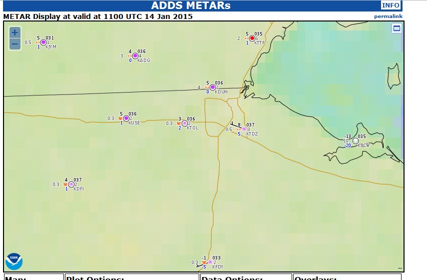
It was an unusual morning with various levels of radiational cooling around Toledo. At 11z, Toledo ranged from 3 to 8 degrees, it was -1 at Findlay, and Port Clinton (PCW) had a low of -14. Toledo (TOL) reached its low of -2 around midnight, and warmed to 3 by sunrise. Does anyone know if Port Clinton (PCW) is experiencing problems with the ASOS device? This is a very low temperature considering it must be close to the lake. image
-
What do you guys think for the LES potential on Jan. 7th? I see 850 and 700mb temps pretty darn cold. 700mb temps down to -34C over the lake, with a 30kt NW wind from the surface to 700mb. I wonder if snow bands will organize to make for a big snow event for NE Ohio. On the other hand, I wonder if this is -too- cold and dry. Then again "too dry" seems a little dumb seeing as how the RH values aren't too bad on the GFS.
-
I'm dreaming of a power outage for Christmas, just like the ones I used to know.
-
High wind watch for northern Ohio.