WVclimo
-
Posts
5,480 -
Joined
-
Last visited
Content Type
Profiles
Blogs
Forums
American Weather
Media Demo
Store
Gallery
Everything posted by WVclimo
-
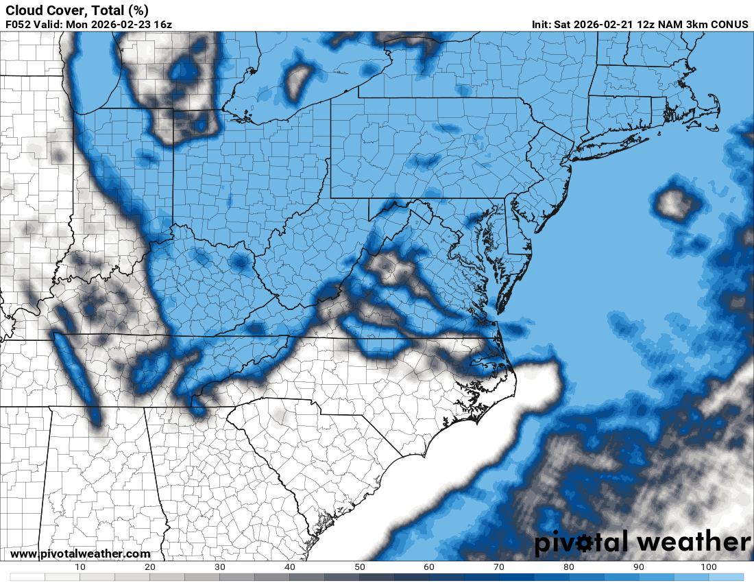
10 hours ago, models had it parked over me. Now its over Frederick, 40 miles east. Lots of time to go to see how that feature comes together.
-
Steady snow all morning here. 0.4" from 0.14" of liquid. 33/32
-
After a brief lull, snow is picking up again. Measured 0.3" from that last band. 34/33
-
Rates are winning right now. All non-paved surfaces are covered. Down to 34°.
-
Pouring huge flakes now, but melting on contact at 35 degrees. Guess its gonna be that kind of day here.
-
Light rain has flipped to light snow now. Down a degree to 36.
-
Light rain. 37/34
-
Currently sunny and 57° with a WSW going into effect 24 hours from now.
-
There's the eye clearing out at the benchmark.

-
Feb 22nd/23rd "There's no way..." Storm Thread
WVclimo replied to Maestrobjwa's topic in Mid Atlantic
Not sure how it was where you are on the coast, but pretty sure PD1 in 1979 dropped 20-25" from Laurel-Seaford up toward Dover. -
Feb 22nd/23rd "There's no way..." Storm Thread
WVclimo replied to Maestrobjwa's topic in Mid Atlantic
33° snow makes the landscape so much prettier than 15° sleet -
Feb 22nd/23rd "There's no way..." Storm Thread
WVclimo replied to Maestrobjwa's topic in Mid Atlantic
The NAM twins are decent for the I-81 crew. 3k gets precip in before dawn, which would be great for laying down a base. 12k holds off until 10 a.m. Both seem to have the inverted trof out this way. Even a bit west of my location, which I haven't seen on any model in a couple of days. -
Feb 22nd/23rd "There's no way..." Storm Thread
WVclimo replied to Maestrobjwa's topic in Mid Atlantic
Latest from LWX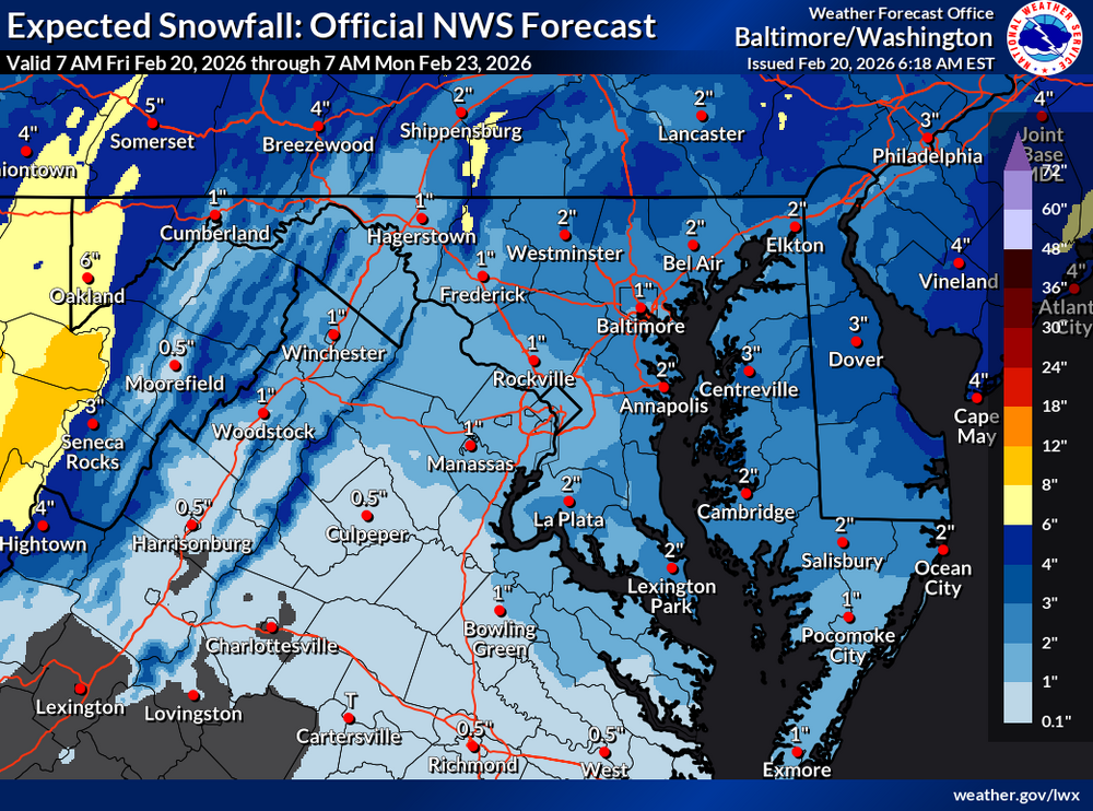
-
Moderate rain still ongoing here. 1.15" so far.
-
Feb 22nd/23rd "There's no way..." Storm Thread
WVclimo replied to Maestrobjwa's topic in Mid Atlantic
Euro actually lays down a slushy inch here before sunrise on Sunday. That would only be my second snowfall of 1" or more this winter, so I'd take it. Gone by noon though, like all but one snowfall this year. -
Schools here on a two-hour delay for freezing fog and low visibility. Currently under 1/8 mile visibility.
-
Hagerstown, MD had a week in January 1961 without snow cover. Martinsburg, WV had 6 days, from 1/8 through 1/13 with bare ground. Otherwise, snow was on the ground at both sites from 12/10 to 2/23.
-
38° with rain and a snow-eating fog. Visibility less than 1 mile. 0.25” in the bucket.
-
Snow flurries. 32°.
-
47 degrees, and other than on rooves, its having very little impact on the snow pack. No water on the edges of piles along driveways and roads. Still the same 5" depth we started the day with.
-
+ 1° here. Still a shot at zero in the next hour.
-
12 hours now of winds here 25-40+ with the last 8 of those more like 30-45+. An 18-hour event with these gusts will be pretty impressive.
-
HECS for Atlanta. I think that would challenge their largest snowstorm ever, and maybe their single greatest season also.
-
MRB gusted to 59. HGR at 51.
-
Lots of blowing snow in the farm fields next to my property. Most of what fell on car tops and my driveway overnight has blown away. 14° with a wind chill of -1